
Workshop Agenda item 6A
Saugatuck Harbor Natural Area Master Plan Update
City Council Workshop, Wednesday, February 19, 2025
Download these 24 pages, 1.8 MB Whole packet, 148 pages, 19.0 MB
Page 2
Text of page 2
City Council Agenda Item Report FROM:
Ryan Cummins, City Manager
MEETING DATE:
February 19, 2025
SUBJECT:
Updated Saugatuck Harbor Natural Area Master Plan
DESCRIPTION: In 2010, the City approved a master plan for the Saugatuck Harbor Natural Area. In 2012, with excess funds following the purchase of the property, the Land Conservancy of West Michigan created a Saugatuck Harbor Natural Area Endowment Fund through the Holland/Zeeland Aea Community Foundation. The purpose of the fund is to support the City in preserving the “sensitive natural and scenic resources, including the native flora, fauna, and natural habits found on the 173-acre natural area located on the south side of the Kalamazoo River on Lake Michigan as outlined in the Saugatuck Harbor Natural Area Master Plan. With preservation as the primary goal, the City will emphasize compatible non-motorized recreation and education activities”. The initial gift to the fund totaled $450,000. The principal of the fund remains in perpetuity. The fund now has a total value of $821,821.35. The funds currently available for use total $225,338.00. In order to access the funds, the following must be met: • Request is made from the City Manager • Demonstration that the funds will be used to further the goals and objectives of the SHNA Management Plan dated April 12, 2010. • The Management Plan is reviewed, updated, and presented to the Community Foundation ever 5 years. The master plan has not been updated since its creation and staff are unable to access the funds for current SHNA needs. Originally, the master plan adopted by the Council contemplated a management board overseeing the property. While a management board was initially created around 2010, it
Page 3
Text of page 3
ceased to exist around the same time. A 2012 Council resolution references the City Council having the authority to update the master plan, but this conflicts with some of the language in the master plan itself. After staff and legal review, and discussions with the Land Conservancy of West Michigan, the attached updates to the master plan are proposed. The proposed updates include: •
Elimination of a requirement for a separate management board. However, keeping with the spirit of the original plan, the City Council will consult with the Land Conservancy to develop management policies and priorities. The Land Conservancy shall be invited to participate and have their advice incorporated into the master plan. The City Council may seek recommendations from the Parks and Public Works Committee (PPW) related to the master plan and other items the PPW ordinance references. Clarifying that park staff and emergency services may access the property for purposes of carrying out their official duties. Updated assessment and management recommendations from the Land Conservancy (see attached report). Inspection of the property by knowledgeable personnel at least once per year.
The Land Conservancy is supportive of these updates and will also be at the workshop meeting for any questions. BUDGET ACTION: None at this time. LEGAL REVIEW: Legal has reviewed historical documents. SAMPLE MOTION: Motion to approve the updated Saugatuck Harbor Natural Area master plan.
Page 2
Page 4
Text of page 4
Management Recommendations for Saugatuck Harbor Natural Area October 2024
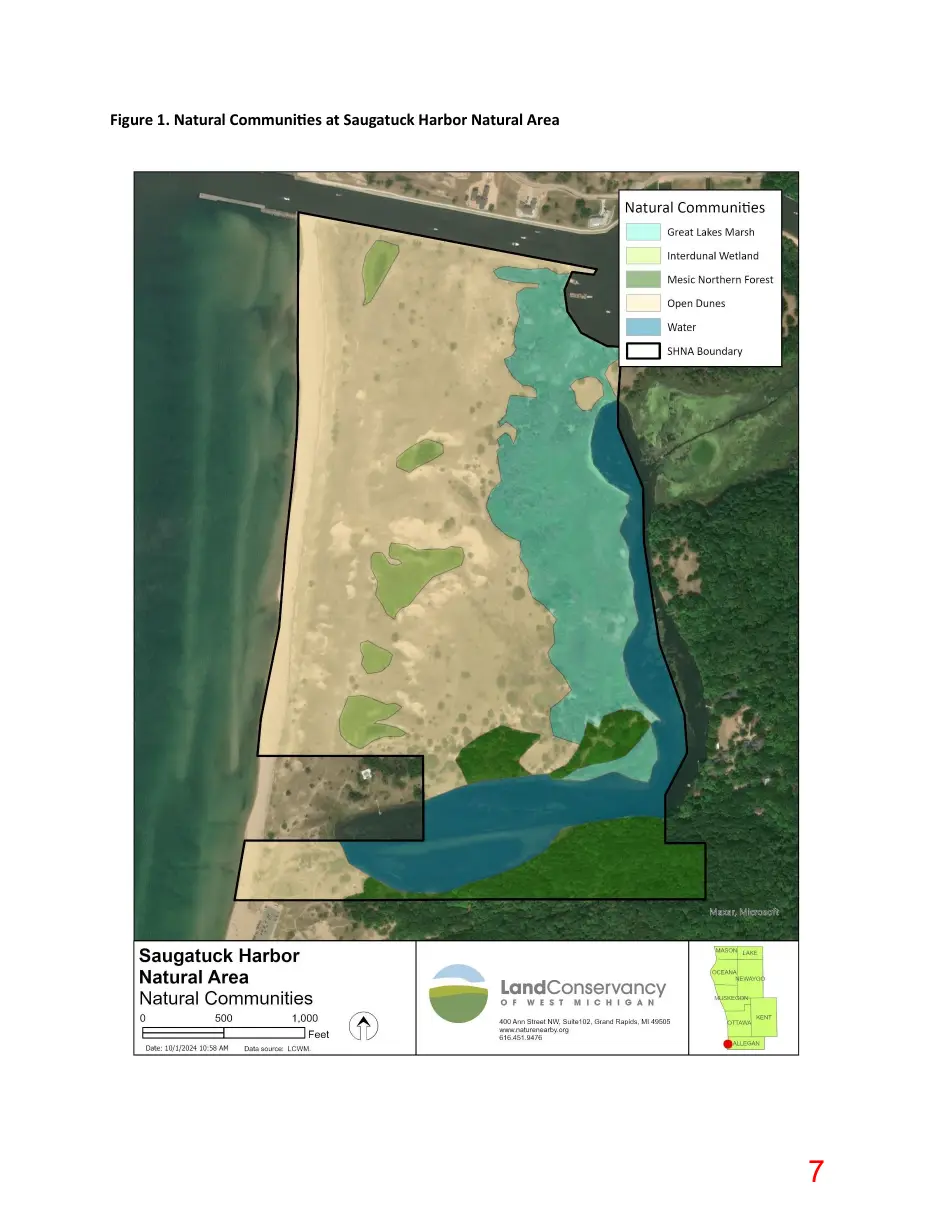
INTRODUCTION Saugatuck Harbor Natural Area (SHNA) is a 173-acre tract of duneland along the Lake Michigan shoreline, just south of the Kalamazoo River mouth. It was permanently protected in 2009 through a partnership between the Land Conservancy of West Michigan (LCWM) and the City of Saugatuck, which now owns and manages the land. Stewardship of the property is guided by a management plan that was developed around the time of acquisition. The City of Saugatuck is in the process of updating the plan to reflect current conditions and management needs. In September 2024, LCWM staff visited the property to delineate natural communities, generate a cursory plant species list, conduct an ecological assessment, and identify management needs to assist the City of Saugatuck in updating the plan. This document summarizes those findings, along with management recommendations for each of the four natural communities onsite (open dunes, interdunal wetland, mesic northern forest, and Great Lakes marsh; Figure 1), plus trails and monitoring.
MANAGEMENT RECOMMENDATIONS Open Dunes The open dunes are the most extensive community type at SHNA and are in excellent condition overall. Natural processes of sand erosion and deposition have generally been allowed to play out unimpeded, a critical factor for sustaining high-quality dune landscapes. Invasive species – most notably Japanese barberry – present a long-term threat, though their abundance is still quite low. Heavy deer browse is apparent throughout the dunes, potentially limiting biodiversity. Off-trail foot traffic, concentrated in the southwest portion of the property, has led to some trampling of vegetation and excessive erosion, although the overall impact to the dunes is fairly minor at this time. Management Recommendations •
Remove Japanese barberry, which is concentrated in shaded areas under trees. Small individuals can be hand-pulled. Larger individuals and well-established patches will require foliar herbicide treatments for successful removal. Effective control will likely require multiple years of treatment. Periodically monitor for other invasive species and take action if they pose a threat to native ecosystems. Continue allowing the natural processes of sand erosion and deposition to continue unimpeded. Avoid planting beach grass, installing sand fences, or taking similar measures to “stabilize” the dunes, except to repair areas of unnatural erosion caused by excessive human activity.
Page 5
Text of page 5
Consider working with local and regional partners to evaluate options for deer population management.
Great Lakes Marsh A large Great Lakes marsh occupies the area between the open dunes and Oxbow Lagoon. The marsh is quite diverse, with both inundated zones and upland rises occurring throughout. High Lake Michigan water levels in 2020 and 2021 drowned out many trees, causing a shift to a more herbaceous plant community. The newly opened canopy also likely facilitated the establishment of invasive phragmites. While currently confined to a relatively small area of the marsh, phragmites presents a severe risk to ecosystem integrity since it can expand rapidly and decimate native communities. Management Recommendations •
Remove phragmites using appropriate foliar herbicide applications. Effective management will likely require multiple years of treatment. This may be the highest management priority on the site, and action should be taken as soon as possible. Remove Japanese barberry and black locust that occur on upland rises within the marsh. Black locust should be removed by girdling or drill-and-fill treatments, while Japanese barberry is best treated with foliar herbicide applications.
Interdunal Wetlands Several interdunal wetlands, a globally rare natural community, occur within the open dunes landscape. These sedgeand rush-dominated communities fluctuate with Lake Michigan water levels. Past and ongoing research studies on the interdunal wetlands at SHNA have improved our understanding of the unique hydrology and biology of these ecosystems. The interdunal wetlands at SHNA are generally in very good ecological condition. Management Recommendations •
No management is recommended at this time beyond periodically monitoring for invasive species and continuing to allow research on the site.
Mesic Northern Forest A mesic northern forest with a mature canopy of red oak, sugar maple, hemlock, and white pine occurs in the southeast corner of the site. The ground layer is very sparsely vegetated and there is almost no natural regeneration of canopy trees. This is almost certainly a result of excessive deer browse. Japanese barberry is scattered throughout the forest and is likely to expand without management. Management Recommendations • • •
Continue treatments for hemlock woolly adelgid a to retain hemlock as an important part of the tree canopy. Remove Japanese barberry through appropriate mechanical or chemical treatments. Effective control will likely require multiple years of treatment. Consider working with local and regional partners to evaluate options for deer population management.
Page 6
Text of page 6
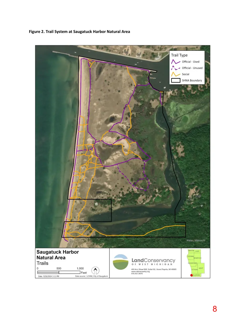
Trails and User Experience A network of trails winds through the SHNA property (Figure 2). Some of these are official trails that are marked with signposts in the field and/or are shown on the trail map on the City of Saugatuck website. Some of these official trails are well-marked and well-used, while other trails are faint, difficult to follow, and receive little to no use. User-created social trails also occur throughout the property. These are concentrated in the southern part of the site near the parking lot and Oval Beach. Excessive use of this area has caused some damage to natural features, including vegetation trampling and accelerated erosion. Management Recommendations • •
Use signs and/or natural barriers (e.g., logs or brush piles) to decommission social trails that go through the Deam property and those that traverse highly-erodible areas. Consider adopting some well-used social trails in the south part of the property as official trails, assuming they do not lead into private property or cause unacceptable damage to natural features. Decommission official trails that are unused and unmaintained. Ensure all official trails are clearly marked in the field. Update trail maps accordingly on the City of Saugatuck website and elsewhere. Consider installing a trail map sign near the parking lot and/or wayfinding signs throughout the property to help visitors navigate the trail system.
Monitoring Regular monitoring is important to assess the condition of habitats and infrastructure, track management progress, and identify issues that may require intervention. SHNA should be inspected by knowledgeable personnel at least once per year. This inspection should be oriented towards assessing invasive species populations, evaluating trail use and conditions, and detecting any other management concerns. Generating a brief report after each year’s monitoring may be useful for sharing findings and detecting changes over time.
Page 7
Text of page 7
Figure 1. Natural Communities at Saugatuck Harbor Natural Area
Page 8
Text of page 8
Figure 2. Trail System at Saugatuck Harbor Natural Area
Page 9
Text of page 9
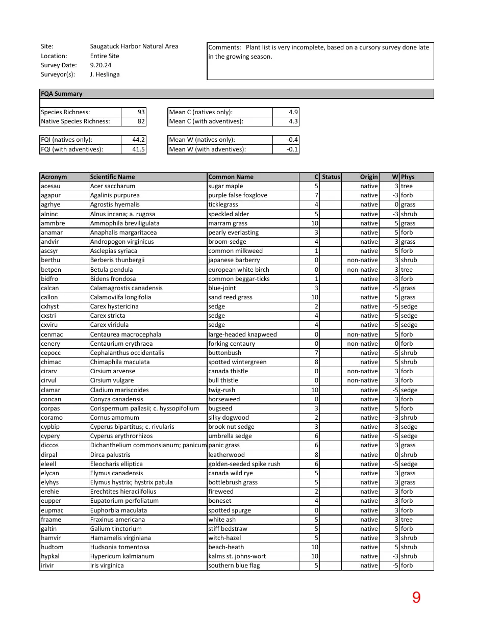
Site: Location: Survey Date: Surveyor(s):
Saugatuck Harbor Natural Area Entire Site 9.20.24 J. Heslinga
Comments: Plant list is very incomplete, based on a cursory survey done late in the growing season.
FQA Summary Species Richness: Native Species Richness:
93 82
Mean C (natives only): Mean C (with adventives):
4.9 4.3
FQI (natives only): FQI (with adventives):
44.2 41.5
Mean W (natives only): Mean W (with adventives):
-0.4 -0.1
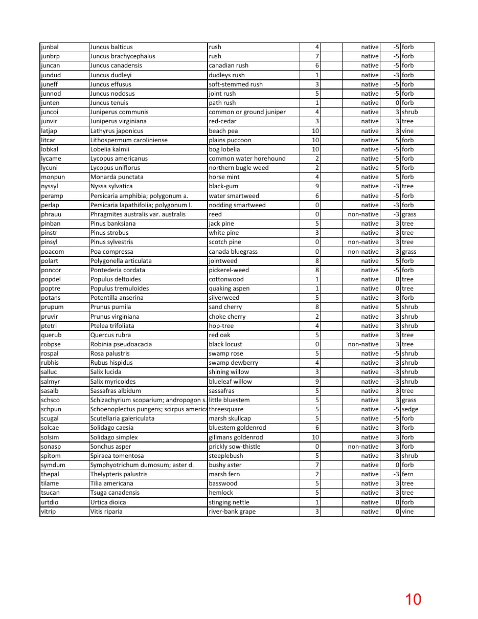
Acronym acesau agapur agrhye alninc ammbre anamar andvir ascsyr berthu betpen bidfro calcan callon cxhyst cxstri cxviru cenmac cenery cepocc chimac cirarv cirvul clamar concan corpas coramo cypbip cypery diccos dirpal eleell elycan elyhys erehie eupper eupmac fraame galtin hamvir hudtom hypkal irivir
Scientific Name Common Name Acer saccharum sugar maple Agalinis purpurea purple false foxglove Agrostis hyemalis ticklegrass Alnus incana; a. rugosa speckled alder Ammophila breviligulata marram grass Anaphalis margaritacea pearly everlasting Andropogon virginicus broom-sedge Asclepias syriaca common milkweed Berberis thunbergii japanese barberry Betula pendula european white birch Bidens frondosa common beggar-ticks Calamagrostis canadensis blue-joint Calamovilfa longifolia sand reed grass Carex hystericina sedge Carex stricta sedge Carex viridula sedge Centaurea macrocephala large-headed knapweed Centaurium erythraea forking centaury Cephalanthus occidentalis buttonbush Chimaphila maculata spotted wintergreen Cirsium arvense canada thistle Cirsium vulgare bull thistle Cladium mariscoides twig-rush Conyza canadensis horseweed Corispermum pallasii; c. hyssopifolium bugseed Cornus amomum silky dogwood Cyperus bipartitus; c. rivularis brook nut sedge Cyperus erythrorhizos umbrella sedge Dichanthelium commonsianum; panicum c. panic grass Dirca palustris leatherwood Eleocharis elliptica golden-seeded spike rush Elymus canadensis canada wild rye Elymus hystrix; hystrix patula bottlebrush grass Erechtites hieraciifolius fireweed Eupatorium perfoliatum boneset Euphorbia maculata spotted spurge Fraxinus americana white ash Galium tinctorium stiff bedstraw Hamamelis virginiana witch-hazel Hudsonia tomentosa beach-heath Hypericum kalmianum kalms st. johns-wort Iris virginica southern blue flag
C Status 5 7 4 5 10 3 4 1 0 0 1 3 10 2 4 4 0 0 7 8 0 0 10 0 3 2 3 6 6 8 6 5 5 2 4 0 5 5 5 10 10 5 -
Origin native native native native native native native native non-native non-native native native native native native native non-native non-native native native non-native non-native native native native native native native native native native native native native native native native native native native native native
W Phys 3 tree -3 forb 0 grass -3 shrub 5 grass 5 forb 3 grass 5 forb 3 shrub 3 tree -3 forb -5 grass 5 grass -5 sedge -5 sedge -5 sedge 5 forb 0 forb -5 shrub 5 shrub 3 forb 3 forb -5 sedge 3 forb 5 forb -3 shrub -3 sedge -5 sedge 3 grass 0 shrub -5 sedge 3 grass 3 grass 3 forb -3 forb 3 forb 3 tree -5 forb 3 shrub 5 shrub -3 shrub -5 forb
Page 10
Text of page 10
junbal junbrp juncan jundud juneff junnod junten juncoi junvir latjap litcar lobkal lycame lycuni monpun nyssyl peramp perlap phrauu pinban pinstr pinsyl poacom polart poncor popdel poptre potans prupum pruvir ptetri querub robpse rospal rubhis salluc salmyr sasalb schsco schpun scugal solcae solsim sonasp spitom symdum thepal tilame tsucan urtdio vitrip
Juncus balticus rush Juncus brachycephalus rush Juncus canadensis canadian rush Juncus dudleyi dudleys rush Juncus effusus soft-stemmed rush Juncus nodosus joint rush Juncus tenuis path rush Juniperus communis common or ground juniper Juniperus virginiana red-cedar Lathyrus japonicus beach pea Lithospermum caroliniense plains puccoon Lobelia kalmii bog lobelia Lycopus americanus common water horehound Lycopus uniflorus northern bugle weed Monarda punctata horse mint Nyssa sylvatica black-gum Persicaria amphibia; polygonum a. water smartweed Persicaria lapathifolia; polygonum l. nodding smartweed Phragmites australis var. australis reed Pinus banksiana jack pine Pinus strobus white pine Pinus sylvestris scotch pine Poa compressa canada bluegrass Polygonella articulata jointweed Pontederia cordata pickerel-weed Populus deltoides cottonwood Populus tremuloides quaking aspen Potentilla anserina silverweed Prunus pumila sand cherry Prunus virginiana choke cherry Ptelea trifoliata hop-tree Quercus rubra red oak Robinia pseudoacacia black locust Rosa palustris swamp rose Rubus hispidus swamp dewberry Salix lucida shining willow Salix myricoides blueleaf willow Sassafras albidum sassafras Schizachyrium scoparium; andropogon s. little bluestem Schoenoplectus pungens; scirpus americanus threesquare Scutellaria galericulata marsh skullcap Solidago caesia bluestem goldenrod Solidago simplex gillmans goldenrod Sonchus asper prickly sow-thistle Spiraea tomentosa steeplebush Symphyotrichum dumosum; aster d. bushy aster Thelypteris palustris marsh fern Tilia americana basswood Tsuga canadensis hemlock Urtica dioica stinging nettle Vitis riparia river-bank grape
4 7 6 1 3 5 1 4 3 10 10 10 2 2 4 9 6 0 0 5 3 0 0 8 8 1 1 5 8 2 4 5 0 5 4 3 9 5 5 5 5 6 10 0 5 7 2 5 5 1 3
native native native native native native native native native native native native native native native native native native non-native native native non-native non-native native native native native native native native native native non-native native native native native native native native native native native non-native native native native native native native native
-5 forb -5 forb -5 forb -3 forb -5 forb -5 forb 0 forb 3 shrub 3 tree 3 vine 5 forb -5 forb -5 forb -5 forb 5 forb -3 tree -5 forb -3 forb -3 grass 3 tree 3 tree 3 tree 3 grass 5 forb -5 forb 0 tree 0 tree -3 forb 5 shrub 3 shrub 3 shrub 3 tree 3 tree -5 shrub -3 shrub -3 shrub -3 shrub 3 tree 3 grass -5 sedge -5 forb 3 forb 3 forb 3 forb -3 shrub 0 forb -3 fern 3 tree 3 tree 0 forb 0 vine
Page 11
Text of page 11
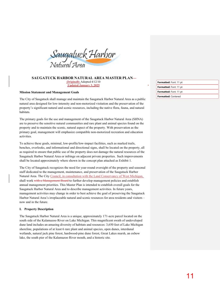
SAUGATUCK HARBOR NATURAL AREA MASTER PLAN – Originally Adopted 4/12/10 Updated January 3, 2025
Mission Statement and Management Goals The City of Saugatuck shall manage and maintain the Saugatuck Harbor Natural Area as a public natural area designed for low-intensity and non-motorized visitation and the preservation of the property’s significant natural and scenic resources, including the native flora, fauna, and natural habitats.
Formatted: Font: 11 pt Formatted: Font: 11 pt Formatted: Font: 11 pt Formatted: Centered
The primary goals for the use and management of the Saugatuck Harbor Natural Area (SHNA) are to preserve the sensitive natural communities and rare plant and animal species found on the property and to maintain the scenic, natural aspect of the property. With preservation as the primary goal, management will emphasize compatible non-motorized recreation and education activities. To achieve these goals, minimal, low-profile/low-impact facilities, such as marked trails, benches, overlooks, and informational and directional signs, shall be located on the property, all as required to ensure that public use of the property does not damage the natural resources of the Saugatuck Harbor Natural Area or infringe on adjacent private properties. Such improvements shall be located approximately where shown in the concept plan attached as Exhibit 1. The City of Saugatuck recognizes the need for year-round oversight of the property and seasonal staff dedicated to the management, maintenance, and preservation of the Saugatuck Harbor Natural Area. The City Council, in consultation with the Land Conservancy of West Michigan, shall work with a Management Board to further develop management policies and establish annual management priorities. This Master Plan is intended to establish overall goals for the Saugatuck Harbor Natural Area and to describe management activities. In future years, management activities may change in order to best achieve the goal of preserving the Saugatuck Harbor Natural Area’s irreplaceable natural and scenic resources for area residents and visitors – now and in the future. I. Property Description The Saugatuck Harbor Natural Area is a unique, approximately 171-acre parcel located on the south side of the Kalamazoo River on Lake Michigan. This magnificent swath of undeveloped dune land includes an amazing diversity of habitats and resources: 3,650 feet of Lake Michigan shoreline, populations of at least 6 rare plant and animal species, open dunes, interdunal wetlands, natural jack pine forest, hardwood-pine dune forest, Great Lakes marsh, an oxbow lake, the south pier of the Kalamazoo River mouth, and a historic site.
Page 12
Text of page 12
SHNA Master Plan –Adopted 4/12/10
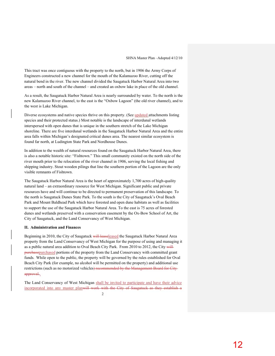
This tract was once contiguous with the property to the north, but in 1906 the Army Corps of Engineers constructed a new channel for the mouth of the Kalamazoo River, cutting off the natural bend in the river. The new channel divided the Saugatuck Harbor Natural Area into two areas – north and south of the channel – and created an oxbow lake in place of the old channel. As a result, the Saugatuck Harbor Natural Area is nearly surrounded by water. To the north is the new Kalamazoo River channel, to the east is the “Oxbow Lagoon” (the old river channel), and to the west is Lake Michigan. Diverse ecosystems and native species thrive on this property. (See updated attachments listing species and their protected status.) Most notable is the landscape of interdunal wetlands interspersed with open dunes that is unique in the southern stretch of the Lake Michigan shoreline. There are five interdunal wetlands in the Saugatuck Harbor Natural Area and the entire area falls within Michigan’s designated critical dunes area. The nearest similar ecosystem is found far north, at Ludington State Park and Nordhouse Dunes. In addition to the wealth of natural resources found on the Saugatuck Harbor Natural Area, there is also a notable historic site: “Fishtown.” This small community existed on the north side of the river mouth prior to the relocation of the river channel in 1906, serving the local fishing and shipping industry. Stout wooden pilings that line the southern portion of the Lagoon are the only visible remnants of Fishtown. The Saugatuck Harbor Natural Area is the heart of approximately 1,700 acres of high-quality natural land – an extraordinary resource for West Michigan. Significant public and private resources have and will continue to be directed to permanent preservation of this landscape. To the north is Saugatuck Dunes State Park. To the south is the City of Saugatuck’s Oval Beach Park and Mount Baldhead Park which have forested and open dune habitats as well as facilities to support the use of the Saugatuck Harbor Natural Area. To the east is 75 acres of forested dunes and wetlands preserved with a conservation easement by the Ox-Bow School of Art, the City of Saugatuck, and the Land Conservancy of West Michigan. II. Administration and Finances Beginning in 2010, the City of Saugatuck will leaseleased the Saugatuck Harbor Natural Area property from the Land Conservancy of West Michigan for the purpose of using and managing it as a public natural area addition to Oval Beach City Park. From 2010 to 2012, the City will purchasepurchased portions of the property from the Land Conservancy with committed grant funds. While open to the public, the property will be governed by the rules established for Oval Beach City Park (for example, no alcohol will be permitted on the property) and additional use restrictions (such as no motorized vehicles) recommended by the Management Board for City approval.. The Land Conservancy of West Michigan shall be invited to participate and have their advice incorporated into any master planwill work with the City of Saugatuck as they establish a 2
Page 13

Text of page 13
SHNA Master Plan –Adopted 4/12/10
Management Board to oversee the for the ecological management of the property. The Board shall be
Page 14
Text of page 14
SHNA Master Plan –Adopted 4/12/10
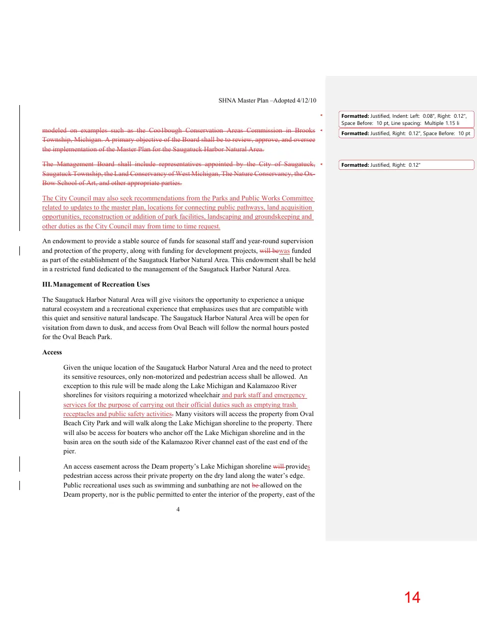
modeled on examples such as the Coo1bough Conservation Areas Commission in Brooks Township, Michigan. A primary objective of the Board shall be to review, approve, and oversee the implementation of the Master Plan for the Saugatuck Harbor Natural Area. The Management Board shall include representatives appointed by the City of Saugatuck, Saugatuck Township, the Land Conservancy of West Michigan, The Nature Conservancy, the OxBow School of Art, and other appropriate parties.
Formatted: Justified, Indent: Left: 0.08", Right: 0.12", Space Before: 10 pt, Line spacing: Multiple 1.15 li Formatted: Justified, Right: 0.12", Space Before: 10 pt
Formatted: Justified, Right: 0.12"
The City Council may also seek recommendations from the Parks and Public Works Committee related to updates to the master plan, locations for connecting public pathways, land acquisition opportunities, reconstruction or addition of park facilities, landscaping and groundskeeping and other duties as the City Council may from time to time request. An endowment to provide a stable source of funds for seasonal staff and year-round supervision and protection of the property, along with funding for development projects, will bewas funded as part of the establishment of the Saugatuck Harbor Natural Area. This endowment shall be held in a restricted fund dedicated to the management of the Saugatuck Harbor Natural Area. III. Management of Recreation Uses The Saugatuck Harbor Natural Area will give visitors the opportunity to experience a unique natural ecosystem and a recreational experience that emphasizes uses that are compatible with this quiet and sensitive natural landscape. The Saugatuck Harbor Natural Area will be open for visitation from dawn to dusk, and access from Oval Beach will follow the normal hours posted for the Oval Beach Park. Access Given the unique location of the Saugatuck Harbor Natural Area and the need to protect its sensitive resources, only non-motorized and pedestrian access shall be allowed. An exception to this rule will be made along the Lake Michigan and Kalamazoo River shorelines for visitors requiring a motorized wheelchair and park staff and emergency services for the purpose of carrying out their official duties such as emptying trash receptacles and public safety activities. Many visitors will access the property from Oval Beach City Park and will walk along the Lake Michigan shoreline to the property. There will also be access for boaters who anchor off the Lake Michigan shoreline and in the basin area on the south side of the Kalamazoo River channel east of the east end of the pier. An access easement across the Deam property’s Lake Michigan shoreline will provides pedestrian access across their private property on the dry land along the water’s edge. Public recreational uses such as swimming and sunbathing are not be allowed on the Deam property, nor is the public permitted to enter the interior of the property, east of the 4
Page 15

Text of page 15
SHNA Master Plan –Adopted 4/12/10
pedestrian access. The access easement across the Deam property also provides for emergency vehicular access.
The Saugatuck Harbor Natural Area includes 18 acres south of the Oxbow Lagoon adjacent to the Mount Baldhead and Oval Beach parks. Access to this property would be through designated foot trails from these parks.
Page 16
Text of page 16
SHNA Master Plan –Adopted 4/12/10
Access to the Saugatuck Harbor Natural Area through the sensitive wetlands that extend from the Kalamazoo River to the Oxbow Lagoon are prohibited. These wetlands are part of Tallmadge Woods and are controlled by the Ox-Bow School of Art and the City of Saugatuck. The use of this wetland is restricted by a permanent conservation easement. As always, the rights of adjacent property owners will be respected. Trails The Management BoardCity Council, in consultation with the Land Conservancy of West Michigan, shall recommend a system of designated pedestrian trails. These trails shall be located so that visitors will be able to enjoy the Saugatuck Harbor Natural Area’s diverse habitats and scenic views while providing protection for sensitive and rare animals and plants and fragile dune and wetland soils. The approximate location of these trails is shown on Exhibit 1. Visitors will access the interior trails from the beach by using 1 or 2 stairways built over the foredune, serving as trailheads. Up to two viewing platforms may be created as part of the trail system to allow visitors to appreciate the views of the area from dunes along Lake Michigan without causing erosion. Up to four all-weather interpretive signs may be placed at logical points along the trail system to provide information about the natural communities and appropriate areas for access and various recreational activities. One of the initial management goals shall be to reduce the number of informal trails that cross the dune ecosystem. These informal trails degrade the scenic views of this landscape and damage the natural dune habitats. Reducing the number of informal trails may be achieved through signage, dune grass plantings, temporary fencing, and/or other means deemed most appropriate. In the future, the walkway along the Kalamazoo River channel may be improved as this is an area that draws significant foot traffic. Improvements along the river channel and near the basin area may include an unobtrusive toilet facility (not greater than one story) to minimize impacts from the traditional recreational use of the basin and the south pier. This location has been identified on the concept plan attached as Exhibit 1. Hunting Initially, the Saugatuck Harbor Natural Area will not be open to recreational hunting because of potential conflicts with other users of the property and users of adjoining properties, which may include school/university student groups, tourists, and ecotourism groups. Should the City and Management BoardCity Council desire to conduct a controlled, permitted hunt, especially for the purpose of reducing habitat destruction in the forested dunes caused by an overabundance of nuisance species, an analysis should be made prior to establishing a hunt of the potential impact of hunting activities on the rare species and habitats, and implement measures to protect these species and habitats. 6
Page 17
Text of page 17
SHNA Master Plan –Adopted 4/12/10
Fishing The Natural Area will maintain the traditional access route to the federally-owned south pier of the Kalamazoo River mouth, which provides the primary access to the local fishery. Signs warning of danger and prohibiting swimming from or near the pier shall be erected there. Funds shall be sought to develop two structures such as platforms or boardwalks on the edge of the Oxbow Lagoon that would provide locations for fishing, as well as viewing the Lagoon. Their general location is shown on Exhibit 1, but it will be based on suitability for fishing and protection of rare species, especially the Blanchard’s cricket frog. Ice fishing on the Oxbow Lagoon is permitted as long as no structures are erected (i.e. no fishing shanties) and private property boundaries are respected. Signs may be erected at the north and south access points to the Lagoon that show property boundaries. Boating Private boats shall be permitted to moor in the “basin” area on the Kalamazoo River channel, just east of the south pier, and along the Lake Michigan shoreline, as has been traditionally done. Non-motorized kayaks and canoes will be allowed on the Oxbow Lagoon. To minimize the impact of watercraft traffic on the sensitive dune and wetland habitats, no facilities to encourage boat access will be provided. Boats must be portaged in from the northeastern section of the Oval Beach parking lot or from the “Basin” area, and boats must be carried in and not dragged, so as not to damage vegetation or to create erosion. Boaters will not be permitted to beach their boats on the west shoreline of the Lagoon, which is critical habitat for the Blanchard’s cricket frog. Swimming and Sunbathing Public swimming is provided at Oval Beach Park. Swimming will not be encouraged on the Lake Michigan beach of the Saugatuck Harbor Natural Area but it will be permitted there at one’s own risk, without provision of lifeguards. Sunbathing will be allowed in these same areas on the beach up to the point where native vegetation begins. Sunbathing from foredune east will not be allowed in order to minimize impacts to the dune slopes and natural communities. Swimming is not allowed in the Oxbow Lagoon. Submerged logs and piers and extensive weed beds make the Lagoon hazardous and unsuitable for swimming.
Page 18
Text of page 18
SHNA Master Plan –Adopted 4/12/10
Camping and Fires No camping or fires shall be allowed anywhere in the Saugatuck Harbor Natural Area. Exercising Dogs For the portion of the property that is south of the Oxbow Lagoon and adjacent to the Mount Baldhead and Oval Beach Parks, dogs shall be regulated as they are in these parks. For the portion of the property that is north of the Oxbow Lagoon and along the Lake Michigan shoreline, leashed dogs are permitted on the beach between Labor Day and Memorial Day (September to May). Dogs are not permitted in the interior of the property north of the Oxbow Lagoon, nor are they permitted along the shoreline of the Oxbow Lagoon, because they would be damaging to rare wildlife populations and habitats and would pose a clean-up problem that would be difficult to enforce. Use by Other Organizations and Institutions As with other City-owned parks, a special use permit must be obtained from the City for the use of the Saugatuck Harbor Natural Area by other organizations or institutions. IV. Management of the Natural Resources The primary management goal of the Saugatuck Harbor Natural Area is to ensure that the native ecosystems and species, many of which are rare, continue to thrive on this remarkable property. Public use of the Saugatuck Harbor Natural Area shall be compatible with the need to preserve sensitive natural habitats and species. In September 2024, Land Conservancy of West Michigan staff visited the property to delineate natural communities, generate a cursory plant species list, conduct an ecological assessment, and identify management needs to assist the City in updating the plan. Management recommendations stated here are based on current knowledge of the property and are expected to change as information and park use changes over time. New strategies and management tools may develop and management should be responsive to changing conditions, even as the primary goal for this Saugatuck Harbor Natural Area remains constant. Generally, the action taken shall be ‘less is more,’ meaning minimal structural/facility improvements shall be an enduring goal. Open Dunes The open dunes are the most extensive community type at SHNA and are in excellent condition overall. Natural processes of sand erosion and deposition have generally been allowed to play out unimpeded, a critical factor for sustaining high-quality dune landscapes. Invasive species – most notably Japanese barberry – present a long-term threat, though their abundance is still quite low. Heavy deer browse is apparent throughout the dunes, potentially limiting biodiversity. Off-trail foot traffic, concentrated in the southwest portion of the property, has led to some trampling of vegetation and excessive erosion, although the
Formatted: Font: 12 pt, Bold Formatted: Font: 12 pt
Page 19
Text of page 19
overall impact to the dunes is fairly minor at this time.
SHNA Master Plan –Adopted 4/12/10
Management Recommendations • Remove Japanese barberry, which is concentrated in shaded areas under trees. Small individuals can be hand-pulled. Larger individuals and well-established patches will require foliar herbicide treatments for successful removal. Effective control will likely require multiple years of treatment. • Periodically monitor for other invasive species and take action if they pose a threat to native ecosystems. • Continue allowing the natural processes of sand erosion and deposition to continue unimpeded. Avoid planting beach grass, installing sand fences, or taking similar measures to “stabilize” the dunes, except to repair areas of unnatural erosion caused by excessive human activity. • Consider working with local and regional partners to evaluate options for deer population management. Great Lakes Marsh A large Great Lakes marsh occupies the area between the open dunes and Oxbow Lagoon. The marsh is quite diverse, with both inundated zones and upland rises occurring throughout. High Lake Michigan water levels in 2020 and 2021 drowned out many trees, causing a shift to a more herbaceous plant community. The newly opened canopy also likely facilitated the establishment of invasive phragmites. While currently confined to a relatively small area of the marsh, phragmites presents a severe risk to ecosystem integrity since it can expand rapidly and decimate native communities. Management Recommendations • Remove phragmites using appropriate foliar herbicide applications. Effective management will likely require multiple years of treatment. This may be the highest management priority on the site, and action should be taken as soon as possible. • Remove Japanese barberry and black locust that occur on upland rises within the marsh. Black locust should be removed by girdling or drill-and-fill treatments, while Japanese barberry is best treated with foliar herbicide applications. Interdunal Wetlands Several interdunal wetlands, a globally rare natural community, occur within the open dunes landscape. These sedgeand rush-dominated communities fluctuate with Lake Michigan water levels. Past and ongoing research studies on the interdunal wetlands at SHNA have improved our understanding of the unique hydrology and biology of these ecosystems. The interdunal wetlands at SHNA are generally in very good ecological condition. Management Recommendations • No management is recommended at this time beyond periodically monitoring for invasive species and continuing to allow research on the site. Mesic Northern Forest A mesic northern forest with a mature canopy of red oak, sugar maple, hemlock, and white pine occurs in the southeast corner of the site. The ground layer is very sparsely vegetated and there is almost no natural regeneration of canopy trees. This is almost certainly a result
Formatted: Font: 12 pt
Formatted: Font: 12 pt, Bold Formatted: Font: 12 pt
Formatted: Font: 12 pt
Formatted: List Paragraph, Indent: Left: 0.75", Space After: 8 pt, Don't add space between paragraphs of the same style, Line spacing: Multiple 1.08 li, Bulleted + Level: 1 + Aligned at: 0.25" + Indent at: 0.5" Formatted: Font: 12 pt, Bold Formatted: Font: 12 pt
Formatted: Font: 12 pt, Bold Formatted: Font: 12 pt
Page 20
Text of page 20
SHNA Master Plan –Adopted 4/12/10
of excessive deer browse. Japanese barberry is scattered throughout the forest and is likely to expand without management.
Management Recommendations • Continue treatments for hemlock woolly adelgid a to retain hemlock as an important part of the tree canopy. • Remove Japanese barberry through appropriate mechanical or chemical treatments. Effective control will likely require multiple years of treatment. • Consider working with local and regional partners to evaluate options for deer population management. Trails and User Experience A network of trails winds through the SHNA property (Figure 2). Some of these are official trails that are marked with signposts in the field and/or are shown on the trail map on the City of Saugatuck website. Some of these official trails are well-marked and well-used, while other trails are faint, difficult to follow, and receive little to no use. User-created social trails also occur throughout the property. These are concentrated in the southern part of the site near the parking lot and Oval Beach. Excessive use of this area has caused some damage to natural features, including vegetation trampling and accelerated erosion. Barbed wire that was previously buried has also been located in certain areas. Management Recommendations • Use signs and/or natural barriers (e.g., logs or brush piles) to decommission social trails that go through the Deam property and those that traverse highly-erodible areas. • Consider adopting some well-used social trails in the south part of the property as official trails, assuming they do not lead into private property or cause unacceptable damage to natural features. • Decommission official trails that are unused and unmaintained. • Ensure all official trails are clearly marked in the field. • Update trail maps accordingly on the City of Saugatuck website and elsewhere. Consider installing a trail map sign near the parking lot and/or wayfinding signs throughout the property to help visitors navigate the trail system. • Barbed wire will be handled on a case by case basis. Areas may be flagged with temporary signage or other methods of communication.
Formatted: Font: 12 pt
Formatted: Font: 12 pt, Bold Formatted: Font: 12 pt Formatted: Indent: Left: 0.5"
Formatted: Font: 12 pt Formatted: Font: 12 pt Formatted: Indent: Left: 0.5" Formatted: Indent: Left: 0.75"
Formatted: Indent: Left: 0.75" Formatted: Font: 12 pt Formatted: Indent: Left: 0.58"
Lake Michigan Shoreline and Foredune The 3,650 feet of Lake Michigan shoreline in the Saugatuck Harbor Natural Area is a continuation of the white sand beach found at the adjacent Oval Beach Park. It is backed by foredunes that rise about 20 feet to an elevation of 600 feet. The foredunes are a mixture of open sand, marram grass, scattered sand cherry and other native foredune plant species.
Page 21
Text of page 21
SHNA Master Plan –Adopted 4/12/10
Lake Michigan levels largely determine the width of the open sand beach. The Kalamazoo River channel pier affects the Saugatuck Harbor Natural Area’s beach growth and attrition. This impact is not expected to be remedied or managed through this project. The primary threat to the beach/foredune natural community at this time is the unrestricted pedestrian use of the property. There are numerous footpaths leading from the beach, up the face of the foredunes, and into the interior dune area. These paths create openings in the vegetation, destabilizing the foredune and trampling native beach vegetation. These numerous paths could also facilitate the invasion of exotic plants that are detrimental to dune systems, such as spotted knapweed and lyme grass. Management recommendations (foredunes) The number of pathways through the foredunes shall be limited to preserve vegetation and reduce erosion. Initial activities shall include designating permitted pathways with signage, by blocking off other routes, and restoration plantings. Dune plantings and/or erosion prevention measures may prove useful in this effort. One to two stairways shall be developed leading over the foredune, approximately where shown on attached Exhibit 1. The stairways will act as trailheads and will help direct foot traffic to the designated trails and scenic overlooks. Invasive exotics will be mapped and removed using standard methods. Surveys for invasive exotics will be done annually, along with their elimination by hand pulling or other best management practices. Open Dunes and Interdunal Wetlands Much of the Saugatuck Harbor Natural Area is comprised of open, rolling dunes interspersed with basins that have interdunal wetland plant communities during periods of higher water levels in Lake Michigan. At this time, with several years of low lake levels, the interdunal wetland areas are dry during a majority of the year, but they continue to have distinctly different vegetation than the surrounding open dunes. Beach grass is now widely established on the dunes. According to accounts of residents, these dunes were much more open and exposed as recently as several decades ago. Areas of open, blowing sand are habitat for Pitcher’s thistle, a plant listed as threatened by the federal and state government. This plant has not been found on the parcel to date. Like the foredunes, the unregulated pedestrian use of the dunes is the principal threat to the dune ecosystem. Foot trails ring the interdunal areas and cross the open dunes. In addition to trampling vegetation and destabilizing the dunes, the potential for the introduction of invasive species is a concern.
Page 22
Text of page 22
SHNA Master Plan –Adopted 4/12/10
Management recommendations (open dunes and interdunal wetlands) Management for the open dunes and interdunal wetlands is similar to that for the foredunes – limit pedestrian pathways, block off and restore trampled areas and excessive trails, develop a designated pathway to points of interest and scenic views, and survey for and eliminate invasive exotic plants annually. Management tools and methods for reducing erosion should be considered, such as a version of a snow fence that can be used as a roll-out pathway in dune environments to mitigate the loss of disturbed sand. It can also be considered on areas exposed to wind. Special attention shall be given to the preservation of the interdunal wetlands. These areas are especially sensitive to trampling. The habitat quality should be maintained so that they are in good condition for times of higher lake levels. Oxbow Lagoon Shoreline The banks of the Oxbow Lagoon or lake are fringed with an emergent wetland that is classified as a Great Lakes marsh because the water levels in the system rise and fall in tandem with Lake Michigan. The width of this wetland varies – in places it is relatively narrow, but in others it is quite wide, particularly toward the northern end of the Oxbow Lagoon. This marsh is the home base for the State-Threatened Blanchard’s cricket frog, and thus is a very important and sensitive habitat. Any management of this area shall take into consideration the potential impacts to the cricket frog population. One of the greatest threats to the marsh fringing the Oxbow Lagoon is trampling. In the past, people walked the banks of the Oxbow Lagoon to fish from the banks or simply to navigate around the lake. During times of low water levels it is very easy to trample a path through the wetland vegetation and to accidently tread on the diminutive frogs. Management Recommendations (Oxbow Lagoon shoreline) To reduce the trampling the wetland receives, no fishing from the wetland shoreline shall be permitted, except at the fishing/viewing structures. A designated trail should re-route traffic onto dry land. Exotic species, such as purple loosestrife and giant reed, will be mapped and controlled annually. These species should be controlled using the best appropriate methods, which will often involve using spot application of herbicides approved for wetland use. Eurasian milfoil is an issue in the Oxbow Lagoon and is sprayed by adjacent landowners. More should be learned about the chemical used in spraying and the potential effect on the cricket frog. 12
Page 23
Text of page 23
SHNA Master Plan –Adopted 4/12/10
Jack Pine Forest The Jack pine forest is located along the edge of the Oxbow Lagoon on that portion of the SHNA property that lies north of the east-west arm of the Lagoon. The pines grow between the open dune/interdunal wetland complex to the west and the marsh along the Lagoon to the east. The significance of this Jack pine forest is due to the use of the forest-wetland edge by the Prairie warbler, which has endangered status in Michigan. There is a population of Prairie warblers that nest in this area each year. The stands of pine also include Austrian pine, a non-native that is currently being removed from the Saugatuck State Park by DNR. In the future, the removal of Austrian pine could be considered for the Saugatuck Harbor Natural Area. Management Recommendations To protect the prairie warbler habitat, the Jack pine forest should not be fragmented or degraded. Trails should not be put into the warbler habitat. Additional research should be done to determine the numbers of warblers using the habitat and what, if anything should be done to promote a sustainable population. This area includes exotic Austrian pine and white poplar, which should ideally be removed. However, studies should be done first to determine what detrimental effect, if any, this would have on the prairie warbler population. Hardwood/Pine Forested Dunes South of the Oxbow Lagoon The wooded dunes south of the Lagoon are higher and have steeper slopes than the open dunes on the remainder of the property. Dominant trees include beech, maple, and oak on the drier slopes, and hemlock in the shadier ravines. Scattered white pines are present as well as other species such as cherry and witch-hazel. There is little ground cover, probably due to the sandy soil and the amount of deer browsing on the herbaceous and shrub layers. These wooded dunes are contiguous with the Mount Baldhead Park wooded dunes and also adjacent to Oval Beach Park. Trails already run through existing property onto the Saugatuck Harbor Natural Area. Management Recommendations This area is contiguous to the Mount Baldhead Park and is cut off from the main portion of the property by the Oxbow Lagoon and the Deam (Lighthouse) parcel. Therefore, it shall be managed as part of the Mount Baldhead Park rather than as a part of the Saugatuck Harbor Natural Area. Preservation of its natural communities will remain the primary management goal. 13
Page 24
Text of page 24
SHNA Master Plan –Adopted 4/12/10
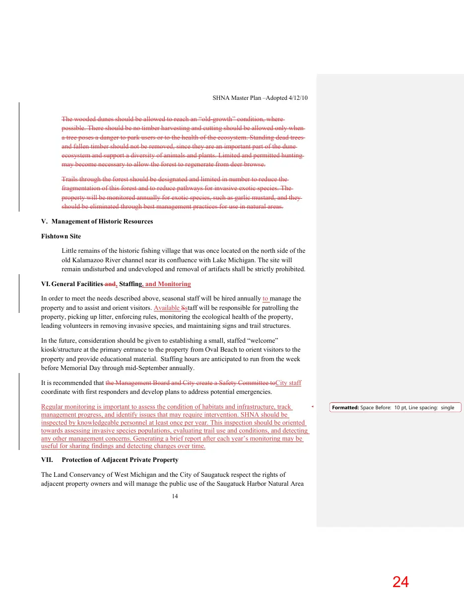
The wooded dunes should be allowed to reach an “old-growth” condition, where possible. There should be no timber harvesting and cutting should be allowed only when a tree poses a danger to park users or to the health of the ecosystem. Standing dead trees and fallen timber should not be removed, since they are an important part of the dune ecosystem and support a diversity of animals and plants. Limited and permitted hunting may become necessary to allow the forest to regenerate from deer browse. Trails through the forest should be designated and limited in number to reduce the fragmentation of this forest and to reduce pathways for invasive exotic species. The property will be monitored annually for exotic species, such as garlic mustard, and they should be eliminated through best management practices for use in natural areas. V. Management of Historic Resources Fishtown Site Little remains of the historic fishing village that was once located on the north side of the old Kalamazoo River channel near its confluence with Lake Michigan. The site will remain undisturbed and undeveloped and removal of artifacts shall be strictly prohibited. VI. General Facilities and, Staffing, and Monitoring In order to meet the needs described above, seasonal staff will be hired annually to manage the property and to assist and orient visitors. Available Sstaff will be responsible for patrolling the property, picking up litter, enforcing rules, monitoring the ecological health of the property, leading volunteers in removing invasive species, and maintaining signs and trail structures. In the future, consideration should be given to establishing a small, staffed “welcome” kiosk/structure at the primary entrance to the property from Oval Beach to orient visitors to the property and provide educational material. Staffing hours are anticipated to run from the week before Memorial Day through mid-September annually. It is recommended that the Management Board and City create a Safety Committee toCity staff coordinate with first responders and develop plans to address potential emergencies. Regular monitoring is important to assess the condition of habitats and infrastructure, track management progress, and identify issues that may require intervention. SHNA should be inspected by knowledgeable personnel at least once per year. This inspection should be oriented towards assessing invasive species populations, evaluating trail use and conditions, and detecting any other management concerns. Generating a brief report after each year’s monitoring may be useful for sharing findings and detecting changes over time. VII.
Formatted: Space Before: 10 pt, Line spacing: single
Protection of Adjacent Private Property
The Land Conservancy of West Michigan and the City of Saugatuck respect the rights of adjacent property owners and will manage the public use of the Saugatuck Harbor Natural Area 14
Page 25

Text of page 25
SHNA Master Plan –Adopted 4/12/10
so that it does not infringe on private property rights. Visitors shall be directed away from adjacent private lands, especially the Deam (Lighthouse) parcel, by means of signage, fencing (if needed), and other appropriate means. On-site management staff will support enforcement of these boundaries.