
Planning Agenda item 5B
Comprehensive Plan Chapters 7-9 Draft Review & Discussion
Planning Commission, Thursday, September 17, 2026
Download these 96 pages, 63.8 MB Whole packet, 124 pages, 68.9 MB
Page 29
Text of page 29
To:
City of Saugatuck, City Council
From:
Grayson Moore, Director of Planning & Zoning
Meeting Date:
September 17, 2026
RE:
Chapters 7-9 Comprehensive Plan Draft
Planning Commissioners, As part of the Comprehensive Plan update, staff has prepared draft Chapters 7–9 for Planning Commission review and discussion. These chapters address Parks, Recreation & Waterfront; Community Facilities & Services; and Regional Partnerships. Together, these chapters address many of the community systems that influence Saugatuck's quality of life but are not necessarily addressed directly through land use and zoning. The discussion and priorities identified through these chapters will also help inform the final chapter of the plan, Future Land Use. The intent of this meeting is not to finalize the language of each chapter. Rather, staff is seeking feedback on the major themes, priorities, and policy direction that should carry forward into the final plan. Chapter 7 – Parks, Recreation & Waterfront A recurring theme throughout the chapter is the need to balance access and recreational use with preservation of natural, historic, and scenic resources. The City's waterfront and natural areas are among its most significant community assets, but many of these areas also contain environmental constraints or aging infrastructure. The chapter also considers the importance of improving connections among parks, trails, neighborhoods, downtown, and the waterfront, as well as improving accessibility where feasible. Future investments will need to consider maintenance of existing facilities, 1
Page 30
Text of page 30
replacement of aging infrastructure, public access, environmental protection, and the City's seasonal demands. Staff is interested in whether the Planning Commission agrees with the general direction of emphasizing: • • • • • •
Maintenance and improvement of existing recreational facilities; Public access to the City's waterfront resources; Improved accessibility; Connections between parks, trails, neighborhoods, downtown, and the waterfront; Protection of natural and environmentally sensitive areas; and Preservation of the scenic, historic, and community character associated with Saugatuck's parks and waterfront.
Chapter 8 – Community Facilities & Services Many services are provided through partnerships with regional agencies or other governmental organizations. The chapter therefore recognizes that the City's ability to provide reliable services is influenced by infrastructure, facilities, seasonal demand, fiscal resources, and coordination with neighboring communities and service providers. A major consideration for the future is the City's ability to maintain and replace existing infrastructure while also responding to changing community needs. As a largely built-out community, Saugatuck will need to be strategic about where limited public resources are directed. Staff is interested in Planning Commission feedback regarding: • • • • •
Which City services and facilities should be considered the highest priorities over the next 10–20 years; How the City should balance maintenance and replacement of existing infrastructure with expansion or addition of new facilities; How seasonal population and tourism should be considered when planning services; Which facilities or infrastructure may require significant investment or replacement; and Where regional cooperation may provide opportunities for more efficient or effective service delivery. 2
Page 31
Text of page 31
Chapter 9 – Regional Partnerships The City participates in numerous regional partnerships, authorities, boards, plans, and initiatives. Housing is one particularly important example. The chapter also identifies regional cooperation related to transportation, trails, economic development, tourism, public safety, utilities, harbor management, and natural resource protection. Staff is interested in identifying which regional issues should receive the greatest emphasis in the next 10–20 years and where the City can benefit most from continued or expanded cooperation with Douglas, Saugatuck Township, Allegan County, and regional organizations. Discussion Questions 1. What should Saugatuck focus on preserving specifically? • What physical, environmental, historic, scenic, or community characteristics are fundamental to Saugatuck's identity and should be protected as the community changes? 2. Where should change occur? • Saugatuck is largely built out, so future change will primarily involve redevelopment, infill, adaptive reuse, and changes to existing properties. Are there particular areas where additional development, redevelopment, or different land uses would be appropriate? 3. What types of change are appropriate? • Beyond identifying where development should occur, what types of housing, commercial activity, lodging, recreation, public spaces, or mixed-use development should the community seek to accommodate? 4. What should future development feel and look like? • What should the plan say about scale, intensity, building form, relationship to streets and public spaces, waterfront character, historic resources, and compatibility with surrounding neighborhoods? 5. Are there any specific things you would like to review or have more information on prior to focusing on future land use? 3
Page 32
Text of page 32
Following this discussion, staff will compile any additional information requested by the Planning Commission and prepare materials addressing planning principles, relevant best practices, and specific comprehensive planning options for Commission consideration. The Commission will then review the maps associated with the Comprehensive Plan and use this information to further evaluate and refine the planning decisions identified throughout the process. Once the Commission is comfortable with the direction and decisions reflected in the plan, staff will prepare a final, information-dense draft that brings together the community data, analysis, priorities, and planning direction developed throughout the update. This document will serve as the primary working guide for the Planning Commission's discussion of Future Land Use. Following completion of the Future Land Use chapter, staff will convert the informationdense draft into a more user-friendly Comprehensive Plan document intended to be accessible to residents, businesses, and community stakeholders. Staff will also prepare a separate executive summary highlighting the plan's key findings, priorities, and recommendations. Respectfully submitted,
Page 33
Text of page 33
City of Saugatuck 2026 Comprehensive Plan Update
Working Draft File
Page 34
Text of page 34
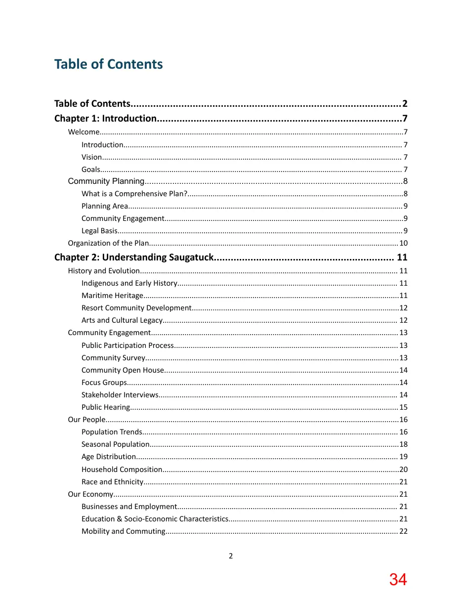
Table of Contents Table of Contents................................................................................................2 Chapter 1: Introduction.......................................................................................7 Welcome.................................................................................................................................................7 Introduction..................................................................................................................................... 7 Vision............................................................................................................................................... 7 Goals................................................................................................................................................ 7 Community Planning................................................................................................................8 What is a Comprehensive Plan?.......................................................................................................8 Planning Area................................................................................................................................... 9 Community Engagement..................................................................................................................9 Legal Basis........................................................................................................................................ 9 Organization of the Plan....................................................................................................................... 10
Chapter 2: Understanding Saugatuck................................................................ 11 History and Evolution........................................................................................................................... 11 Indigenous and Early History......................................................................................................... 11 Maritime Heritage..........................................................................................................................11 Resort Community Development...................................................................................................12 Arts and Cultural Legacy................................................................................................................ 12 Community Engagement...................................................................................................................... 13 Public Participation Process........................................................................................................... 13 Community Survey.........................................................................................................................13 Community Open House................................................................................................................14 Focus Groups..................................................................................................................................14 Stakeholder Interviews.................................................................................................................. 14 Public Hearing................................................................................................................................ 15 Our People............................................................................................................................................16 Population Trends.......................................................................................................................... 16 Seasonal Population.......................................................................................................................18 Age Distribution............................................................................................................................. 19 Household Composition.................................................................................................................20 Race and Ethnicity..........................................................................................................................21 Our Economy........................................................................................................................................ 21 Businesses and Employment......................................................................................................... 21 Education & Socio-Economic Characteristics................................................................................. 21 Mobility and Commuting............................................................................................................... 22 2
Page 35
Text of page 35
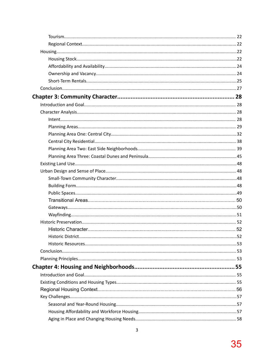
Tourism.......................................................................................................................................... 22 Regional Context............................................................................................................................ 22 Housing.................................................................................................................................................22 Housing Stock.................................................................................................................................22 Affordability and Availability.......................................................................................................... 24 Ownership and Vacancy.................................................................................................................24 Short-Term Rentals.........................................................................................................................25 Conclusion............................................................................................................................................ 27
Chapter 3: Community Character...................................................................... 28 Introduction and Goal.......................................................................................................................... 28 Character Analysis................................................................................................................................ 28 Intent............................................................................................................................................. 28 Planning Areas............................................................................................................................... 29 Planning Area One: Central City.....................................................................................................32 Central City Residential.................................................................................................................. 38 Planning Area Two: East Side Neighborhoods............................................................................... 39 Planning Area Three: Coastal Dunes and Peninsula.......................................................................45 Existing Land Use..................................................................................................................................48 Urban Design and Sense of Place......................................................................................................... 48 Small-Town Community Character.................................................................................................48 Building Form.................................................................................................................................48 Public Spaces..................................................................................................................................49 Transitional Areas............................................................................................................ 50 Gateways........................................................................................................................................50 Wayfinding..................................................................................................................................... 51 Historic Preservation............................................................................................................................ 52 Historic Character............................................................................................................ 52 Historic District...............................................................................................................................52 Historic Resources..........................................................................................................................53 Conclusion............................................................................................................................................ 53 Planning Principles............................................................................................................................... 53
Chapter 4: Housing and Neighborhoods............................................................ 55 Introduction and Goal.......................................................................................................................... 55 Existing Conditions and Housing Types................................................................................................ 55 Regional Housing Context..................................................................................................... 56 Key Challenges......................................................................................................................................57 Seasonal and Year-Round Housing.................................................................................................57 Housing Affordability and Workforce Housing...............................................................................57 Aging in Place and Changing Housing Needs................................................................................. 58 3
Page 36
Text of page 36
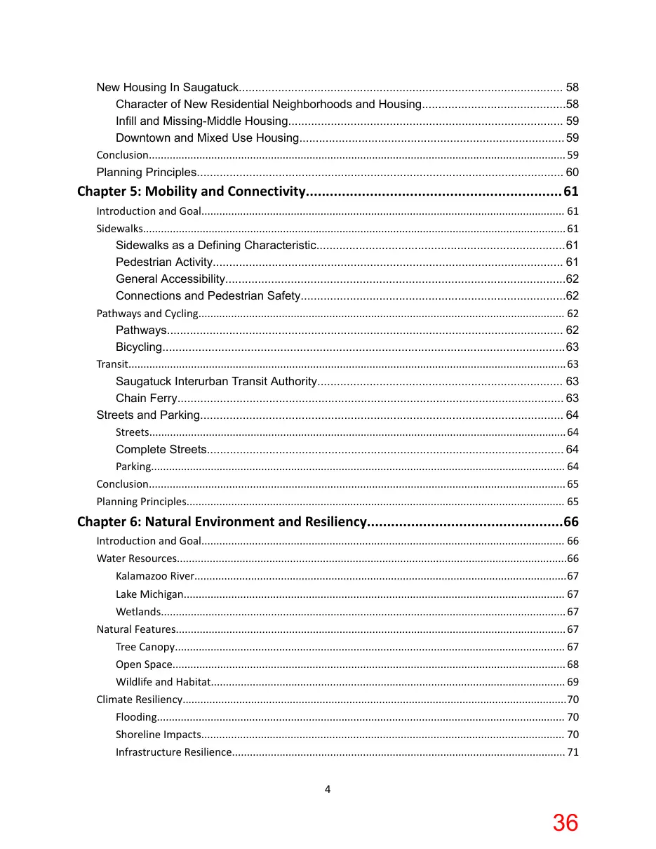
New Housing In Saugatuck................................................................................................... 58 Character of New Residential Neighborhoods and Housing............................................58 Infill and Missing-Middle Housing.................................................................................... 59 Downtown and Mixed Use Housing................................................................................. 59 Conclusion............................................................................................................................................ 59 Planning Principles................................................................................................................ 60
Chapter 5: Mobility and Connectivity................................................................ 61 Introduction and Goal.......................................................................................................................... 61 Sidewalks.............................................................................................................................................. 61 Sidewalks as a Defining Characteristic............................................................................61 Pedestrian Activity........................................................................................................... 61 General Accessibility........................................................................................................62 Connections and Pedestrian Safety.................................................................................62 Pathways and Cycling........................................................................................................................... 62 Pathways......................................................................................................................... 62 Bicycling...........................................................................................................................63 Transit................................................................................................................................................... 63 Saugatuck Interurban Transit Authority........................................................................... 63 Chain Ferry...................................................................................................................... 63 Streets and Parking............................................................................................................... 64 Streets............................................................................................................................................64 Complete Streets............................................................................................................. 64 Parking........................................................................................................................................... 64 Conclusion............................................................................................................................................ 65 Planning Principles............................................................................................................................... 65
Chapter 6: Natural Environment and Resiliency.................................................66 Introduction and Goal.......................................................................................................................... 66 Water Resources...................................................................................................................................66 Kalamazoo River.............................................................................................................................67 Lake Michigan................................................................................................................................ 67 Wetlands........................................................................................................................................ 67 Natural Features................................................................................................................................... 67 Tree Canopy................................................................................................................................... 67 Open Space.................................................................................................................................... 68 Wildlife and Habitat....................................................................................................................... 69 Climate Resiliency.................................................................................................................................70 Flooding......................................................................................................................................... 70 Shoreline Impacts.......................................................................................................................... 70 Infrastructure Resilience................................................................................................................ 71 4
Page 37
Text of page 37
Sustainability........................................................................................................................................ 71 Conclusion............................................................................................................................................ 73 Planning Principles............................................................................................................................... 74
Chapter 7: Parks, Recreation, and Waterfront................................................... 75 Introduction and Goal.......................................................................................................................... 75 City Parks.............................................................................................................................................. 75 Trails..................................................................................................................................................... 75 Public Access........................................................................................................................................ 75 Waterfront Character........................................................................................................................... 75 Harbor and Marina Areas..................................................................................................................... 75 Recreational Opportunities.................................................................................................................. 76 Conclusion............................................................................................................................................ 76 Planning Principles............................................................................................................................... 76
Chapter 8: Community Facilities and Services................................................... 77 Introduction and Goal.......................................................................................................................... 77 Public Safety......................................................................................................................................... 77 Utilities................................................................................................................................................. 77 Schools................................................................................................................................................. 77 Municipal Facilities............................................................................................................................... 77 Future Service Needs............................................................................................................................77 Conclusion............................................................................................................................................ 77 Planning Principles............................................................................................................................... 78
Chapter 9: Regional Partnerships...................................................................... 79 Introduction and Goal.......................................................................................................................... 79 Tri-Community Relationship................................................................................................................. 79 Regional Housing Efforts.......................................................................................................................79 Transportation Partnerships................................................................................................................. 79 Economic Development Partnerships...................................................................................................79 Shared Services.................................................................................................................................... 79 Conclusion............................................................................................................................................ 79 Planning Principles............................................................................................................................... 80
Chapter 10: Future Land Use............................................................................. 81 Introduction and Goal.......................................................................................................................... 81 Planning Framework.............................................................................................................................81 Future Land Use Plan............................................................................................................................81 Future Land Use Map.....................................................................................................................81 Future Land Use Categories........................................................................................................... 81 Zoning Plan.....................................................................................................................................82 5
Page 38
Text of page 38
Opportunity Areas................................................................................................................................ 82 Neighborhoods.............................................................................................................................. 83 Downtown......................................................................................................................................83 Waterfront..................................................................................................................................... 83 Blue Star Corridor.......................................................................................................................... 83 Gateways........................................................................................................................................83 Conclusion............................................................................................................................................ 83 Planning Principles............................................................................................................................... 83
Chapter 11: Action Plan.................................................................................... 85 Introduction..........................................................................................................................................85 Action Plan..................................................................................................................................... 85 Implementation Table.......................................................................................................................... 86 Measuring Success............................................................................................................................... 87 Overview........................................................................................................................................ 87 Indicators....................................................................................................................................... 87
Appendix.......................................................................................................... 88 Attachment 1: Public Hearing Notice................................................................................................... 88 Attachment 2: Planning Commission Resolution..................................................................................88 Attachment 3: City Council Resolution................................................................................................. 88
Page 39
Text of page 39
Chapter 1: Introduction Welcome Introduction The City of Saugatuck is a community defined by its nationally recognized waterfront, historic neighborhoods, vibrant arts and cultural heritage, thriving downtown, and natural environment. Together, these qualities have created a distinctive sense of place that is valued by residents, businesses, and visitors alike. As our community continues to evolve, thoughtful planning is essential to preserving the character that make Saugatuck unique while preparing for future opportunities. This Comprehensive Plan serves as the community’s long-range guide for managing growth, protecting valued resources, and making informed decisions about land use, public investment, transportation, housing, economic development, and environmental stewardship. Developed through public engagement and collaboration with residents, business owners, elected and appointed officials, this Plan reflects the community’s shared values and goals. The Comprehensive Plan is intended to be a living document. While it establishes a long-term direction, it should also remain flexible enough to respond to changing community needs, emerging opportunities, and future challenges.
Vision It is the long term goal of this Comprehensive Plan to improve the quality of life for all citizens in the City of Saugatuck through implementation of policies and best practices that preserve the existing small town character and achieve sustainable development which meet the needs of the present generation without compromising the ability of future generations to meet their needs.
Goals The goals presented throughout this Comprehensive Plan are organized around several key planning themes that collectively support the City’s long-term vision. •
Community Character: See options for discussion on the first page of Chapter 3.
Housing and Neighborhoods:
Mobility and Connectivity:
Natural Environment & Resiliency:
Parks, Recreation, Waterfront, and Community Facilities:
Regional Partnerships and Priorities:
Future Land Use: 7
Page 40
Text of page 40
Community Planning What is a Comprehensive Plan? A Comprehensive Plan is a long-range policy document that guides how a community will grow, develop, and change over time. The Plan brings together community values, public input, technical analysis, and data to establish a vision for the future. It identifies goals, policies, and recommendations that guide decisions related to land use, housing, transportation, infrastructure, parks, natural resources, economic development, and community character. Unlike the Zoning Ordinance, the Comprehensive Plan does not regulate individual properties. Instead, it provides the policy framework that guides future zoning decisions, capital improvements, public investments, and community development initiatives. Together, these implementation tools help ensure that future decisions remain consistent with the community's vision. This Comprehensive Plan is intended to be used as a practical decision-making tool by City officials, residents, property owners, developers, and community partners. The Plan is organized to guide users through a logical planning process: ● ● ● ● ●
Vision - Begin with the community vision and guiding principles that establish the overall direction for Saugatuck's future. Topics - Review individual chapters for detailed goals, policies, and recommendations related to specific planning topics. Future Land Use - Reference the Future Land Use Map to understand the City's long-term development pattern and planning objectives. Decision Making - Use the Plan to evaluate development proposals, zoning requests, public investments, capital improvement projects, and policy decisions. Implementation - Recognize that the Comprehensive Plan is a living document intended to guide ongoing decision-making while adapting to changing community needs through periodic review and updates.
The Comprehensive Plan is intended to serve a wide range of users throughout the community including: ●
City Council - Uses the Plan to establish policy direction, prioritize capital improvements and evaluate public investments. ○ Example: Determining whether to fund a new park, reconstruct a street, or expand public utilities. Planning Commission - Use the Plan when reviewing rezonings, site plans, special land uses, ordinance amendments, and long-range planning initiatives. ○ Example: Evaluating whether a proposed rezoning is consistent with the Future Land Use Map and the community's long-term vision. City Staff - Use the Plan to guide daily planning decisions, administer development regulations, and coordinate infrastructure improvements. ○ Example: Reviewing development proposals or preparing recommendations for elected and appointed officials. Property Owners - Use the Plan to better understand the City’s long-term vision for their neighborhood and nearby areas. 8
Page 41
Text of page 41
○ Example: Understanding how future public improvements or land use changes may affect their property. Developers and Business Owners - Use the Plan to understand the City’s expectations for future development and investment. ○ Example: Identifying areas appropriate for redevelopment or determining whether a proposed project aligns with community goals. Residents - Use the Plan to understand community priorities and participate in future planning decisions. ○ Example: Providing informed comments during public hearings or advocating for neighborhood improvements or changes. Regional Partners and Public Agencies - Use the Plan to coordinate projects and investments that extend beyond municipal boundaries. ○ Example: Collaborating on transportation improvements, environmental initiatives, utility planning, or regional trail connections. Community Organizations Uses the Plan to align programs, grant opportunities, and partnerships with community priorities. ○ Example: Pursuing funding for housing initiatives, public art, environmental stewardship, or recreational improvements.
Planning Area This Comprehensive Plan applies to all land within the municipal boundaries of the City of Saugatuck. Because planning extends beyond jurisdictional boundaries, the Plan also recognizes the City's longstanding partnerships with neighboring communities and regional organizations. Building upon the collaborative foundation established through previous Tri-Community planning efforts, this Plan acknowledges that issues such as transportation, housing, economic development, environmental stewardship, and recreation are best addressed through continued regional cooperation.
Community Engagement As part of the comprehensive planning process, the City conducted a community survey, hosted a community open house as a kickoff event, and provided opportunities for focus group discussions and stakeholder interviews. Together, these engagement efforts helped shape the overall vision, goals, and direction of the planning process. As this Comprehensive Plan is intended to reflect the community's vision for its future, public input served as a fundamental component in developing its recommendations and policies.
Legal Basis This Comprehensive Plan has been prepared under the authority of the Michigan Planning Enabling Act (Public Act 33 of 2008, as amended), which authorizes local governments to prepare and adopt long-range community plans to promote the public health, safety, and general welfare. The Act further requires that zoning ordinances be based upon an adopted plan. Accordingly, this Comprehensive Plan provides the policy foundation for future land use decisions, amendments to the Zoning Ordinance, capital improvement planning, and other community development initiatives. While 9
Page 42
Text of page 42
the Plan establishes the City's long-term vision and policy direction, the Zoning Ordinance serves as the regulatory tool used to implement that vision through specific development standards.
Organization of the Plan The Comprehensive Plan is organized into chapters that move from understanding the City today to outlining strategies for the future. The early chapters describe existing conditions, community input, and the foundation for planning. Later chapters establish goals, principles, and actions, along with a land use strategy and an implementation program. • Chapter Two: Understanding Saugatuck: Provides an overview of the City’s existing conditions, demographics, and community engagement opportunities. • Chapter Three: Community Character: Analyze community characteristics, including existing land uses, urban design, historic preservation, and planning principles. • Chapter Four: Housing and Neighborhoods: Addressing housing conditions, neighborhood preservation, existing housing diversity, and future residential opportunities. • Chapter Five: Mobility and Connectivity: Evaluation of streets, sidewalks, bicycle facilities, public transit, parking, and opportunities to improve transportation. • Chapter Six: Natural Environment and Resiliency: Explores Saugatuck's natural resources, including its waterways, dunes, wetlands, woodlands, and other defining natural features. The chapter establishes strategies for environmental stewardship, climate resilience, shoreline planning, and the long-term protection of the City's ecological assets. • Chapter Seven: Parks, Waterfront, and Community Facilities: Examine the City’s parks, trails, waterfront access, recreational amenities, public spaces, municipal facilities, infrastructure, utilities, and public services. The chapter identifies opportunities to enhance community assets while ensuring public facilities continue to support residents, businesses, and visitors. • Chapter Eight: Regional Partnerships and Priorities: Highlights collaboration with neighboring communities and regional organizations on transportation, housing, environmental protection, tourism, economic development, and other shared initiatives. • Chapter Nine: Future Land Use: Establishes the Future Land Use Map and supporting policies that guide future growth, redevelopment, preservation, and land use decisions. • Chapter Ten: Action Plan: Identifies implementation strategies, priorities, responsible parties, and tools needed to achieve the vision and goals of the Comprehensive Plan.
Page 43
Text of page 43
Chapter 2: Understanding Saugatuck History and Evolution Indigenous and Early History Prior to European-American settlement, the Saugatuck area was part of the homeland and seasonal use territory of the Ottawa (Odawa) and Potawatomi peoples. These Indigenous communities maintained a close relationship with the region’s rivers, lakes, forests, and dunes using the landscape for seasonal settlement, fishing, hunting, and trade. Archaeological and historical evidence indicates that the broader Lake Michigan shoreline supported long-standing Indigenous use patterns well before the 19th century. European-American fur traders began to move through the region in the early 1800s, followed by permanent settlement in the 1830s. One of the earliest recorded settlers was William Butler, who arrived around 1830 and is associated with early land claims and development activity near the mouth of the Kalamazoo River. As settlement expanded, a small village began to take shape in proximity to the river outlet. The name “Saugatuck” is widely understood to derive from a Potawatomi word generally interpreted as “mouth of the river” or “outlet of the river,” reflecting the community’s geographic relationship to the Kalamazoo River and Lake Michigan.
Maritime Heritage Saugatuck’s early growth was closely tied to its location at the mouth of the Kalamazoo River and its access to Lake Michigan. The river served as an important transportation corridor for moving timber and other goods between inland areas and regional Great Lakes markets. During the mid-19th century, the local economy developed around lumbering and related industries, including sawmills, barrel-making, and other wood-product manufacturing. Timber harvested from surrounding forests was transported via the river to Lake Michigan, contributing to regional development during a period of rapid growth in western Michigan. While Saugatuck participated in broader Great Lakes maritime trade, including vessel activity and shipping-related industries, its scale was typical of a small river port community rather than a major shipbuilding center. Water transportation, including ferry crossings of the Kalamazoo River, remained an important part of daily life and connectivity between the developing communities on either side of the river. As local timber resources were depleted by the late 19th century, the maritime economy gradually transitioned away from extraction-based shipping toward tourism and recreational uses of the waterfront.
Page 44
Text of page 44
Resort Community Development By the late 19th century, Saugatuck began transitioning from a resource-based economy to a seasonal resort and recreational destination. As the lumber industry declined, the community’s scenic setting along Lake Michigan, the Kalamazoo River, and surrounding dune landscapes increasingly attracted visitors seeking leisure and retreat. A cottage and resort culture emerged during this period, supported by steamboat and rail connections in the broader region. Saugatuck developed as a small but active destination for seasonal residents and visitors from nearby urban centers, particularly Chicago and western Michigan communities. Unlike many rapidly industrializing Great Lakes cities, Saugatuck retained a relatively intact historic building fabric, which today contributes to its recognized architectural diversity. The community includes examples of Greek Revival, Italianate, Arts and Crafts, and Colonial Revival architecture, reflecting multiple eras of development. Over time, the community developed an intentional approach to historic preservation, including the establishment of historic district protections and collaboration with local historical organizations. These efforts have helped maintain the character of the downtown and surrounding residential areas while supporting tourism as a continuing economic driver.
Arts and Cultural Legacy In the early 20th century, Saugatuck emerged as an artist destination, building on its natural setting and growing reputation as a quiet retreat from urban life. Artists from Chicago and other Midwestern cities were drawn to the area’s landscapes and seasonal atmosphere. A key milestone in this development was the founding of the Ox-Bow School of Art in 1910 as an extension of the School of the Art Institute of Chicago. Located on Ox-Bow Lagoon, the school became an influential center for art education and helped establish Saugatuck as a recognized creative community. Throughout the 20th century, the arts played an increasingly important role in shaping the local economy and identity. Galleries, studios, and cultural institutions expanded, contributing to what is now commonly referred to as the “Art Coast of Michigan.” In the midto late-20th century, Saugatuck also became known as a welcoming destination for LGBTQ+ visitors and residents. This identity evolved over time and contributed to the community’s broader reputation for inclusivity and cultural openness. Today, arts and culture remain central to Saugatuck’s identity, reinforcing its role as a regional destination and shaping both community character and economic activity.
Page 45
Text of page 45
Community Engagement Public Participation Process Public engagement was a central component of the comprehensive planning process and helped ensure that the plan reflects the community's vision for the future. The following section summarizes the outreach efforts undertaken and the public input that informed the goals, policies, and recommendations of this Comprehensive Plan.
Community Survey The City of Saugatuck conducted a community-wide survey from August through early October 2025 to gather input that would help shape the Comprehensive Plan. A total of 386 individuals participated, including full-time and seasonal residents, business owners, property owners, and other community stakeholders. The survey provided valuable insight into the community's strengths, challenges, and priorities for the future. Overall, respondents expressed strong appreciation for the qualities that make Saugatuck unique. The City's small-town character, walkable downtown, vibrant arts and cultural community, locally owned businesses, and access to the Kalamazoo River and Lake Michigan were consistently identified as defining features that should be preserved. Participants also expressed broad support for thoughtful investment in the City's future. Improving sidewalks, crosswalks, multi-use pathways, and bicycle facilities emerged as one of the strongest priorities, along with preserving neighborhood character, protecting the tree canopy and natural environment, and maintaining a vibrant downtown that continues to serve residents and visitors alike. Many respondents also supported strategies that strengthen the year-round economy while respecting the City's historic scale and community character. Survey participants emphasized the importance of environmental stewardship and resiliency, improved pedestrian connectivity, and continued support for local businesses and public infrastructure. These recurring themes directly informed the goals, policies, and recommendations presented throughout this Comprehensive Plan. Survey Highlights ● ● ● ● ● ●
386 total survey responses 222 respondents identified as City residents 80% of resident respondents live in single-family detached homes 87% supported preserving existing neighborhood character 92% agreed that preserving and expanding the City's tree canopy should remain a priority 57% supported exploring the creation of a Downtown Development Authority to help fund public improvements
Top Community Priorities
Page 46
Text of page 46
1. Maintain a vibrant downtown while preserving Saugatuck's small-town character. 2. Foster a welcoming and inclusive community. 3. Improve sidewalks, crosswalks, pathways, and bicycle connectivity. 4. Protect natural resources through environmental sustainability and resiliency. The survey findings established an important foundation for the Comprehensive Plan by confirming that residents value thoughtful stewardship over significant change. The community's vision focuses on preserving Saugatuck's distinctive character while making strategic investments that enhance walkability, environmental quality, public infrastructure, and the overall quality of life.
Community Open House The first community open house was held on September 30, 2025, as an early step in the comprehensive planning process to gather input from residents and stakeholders regarding community values, priorities, and the future of Saugatuck. Approximately 28 participants attended and participated in a series of interactive activities, including mapping exercises, voting activities, and written comment boards. Overall, participants emphasized preserving Saugatuck's small-town character, waterfront, natural resources, and arts community while improving walkability, public spaces, waterfront access, year-round livability, and downtown amenities, with limited support for significant physical change outside of a few targeted areas.
Focus Groups Insert summary if/when this occurs.
Stakeholder Interviews As part of the Comprehensive Plan process, the City conducted stakeholder interviews to gather perspectives from individuals and organizations with unique knowledge and experience within the community. These conversations provided an opportunity to explore specific topics in greater depth than was possible through the community survey or public open house. Stakeholder interviews were intended to complement broader public engagement by identifying community strengths, challenges, and opportunities from the perspective of those who regularly interact with Saugatuck's neighborhoods, businesses, public spaces, and transportation network. While each interview reflected the experiences of a particular group, many of the themes aligned closely with the broader community feedback received throughout the planning process. The following summarizes key themes identified during stakeholder interviews conducted as part of the Comprehensive Plan. Community Walking Group City staff met with members of a long-standing community walking group that has regularly explored Saugatuck on foot since 2006. The group includes approximately 90 members, with around 30 participants routinely walking within the city each week. Their regular routes through downtown, 14
Page 47
Text of page 47
neighborhoods, Oval Beach, and the Mount Baldhead area provide a unique perspective on pedestrian infrastructure and accessibility. Participants consistently emphasized the importance of maintaining and enhancing Saugatuck's walkability. While they expressed appreciation for recent sidewalk improvements, including the Maple Street project, and recognized the City's commitment to winter sidewalk maintenance, they also identified opportunities to improve pedestrian safety and accessibility throughout the community. Key discussion topics included improving pedestrian crossings at major intersections, repairing uneven sidewalks, filling sidewalk gaps, expanding pedestrian connectivity, and exploring opportunities to extend the boardwalk system. Participants also discussed the growing interaction between pedestrians and electric bicycles, suggesting that additional bicycle infrastructure, wider sidewalks where feasible, rider education, and clearer expectations for shared-use areas could improve safety for all users. One location receiving particular attention was the intersection of Holland Street and Blue Star Highway, where participants described challenges crossing the roadway safely and suggested that future intersection improvements should prioritize pedestrian safety. Overall, the interview reinforced a community-wide desire to continue investing in safe, accessible, and connected pedestrian infrastructure while balancing the needs of pedestrians, bicyclists, motorists, residents, and visitors. Key Takeaways ● Improve pedestrian safety at key intersections, particularly Holland Street and Blue Star Highway. ● Continue investing in sidewalks, accessibility improvements, and routine maintenance. ● Expand pedestrian connectivity through additional sidewalks, pathways, and boardwalk connections. ● Improve the visibility and safety of pedestrian crossings throughout the city. ● Address interactions between pedestrians and e-bike users through infrastructure improvements, education, and operational strategies.
Public Hearing A public hearing was held on _______ to receive comments on the proposed Comprehensive Plan following completion of the 63-day notice and review period required by the Michigan Planning Enabling Act. The public hearing provided the official opportunity to review the proposed plan and submit comments prior to its adoption. Comments received during the public hearing and review period were considered by the Planning Commission before making its recommendation to the City Council regarding adoption of the Comprehensive Plan.
Page 48
Text of page 48
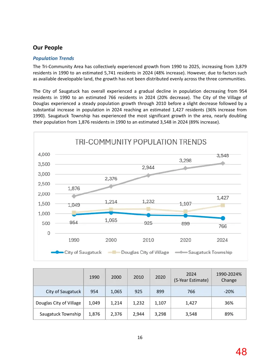
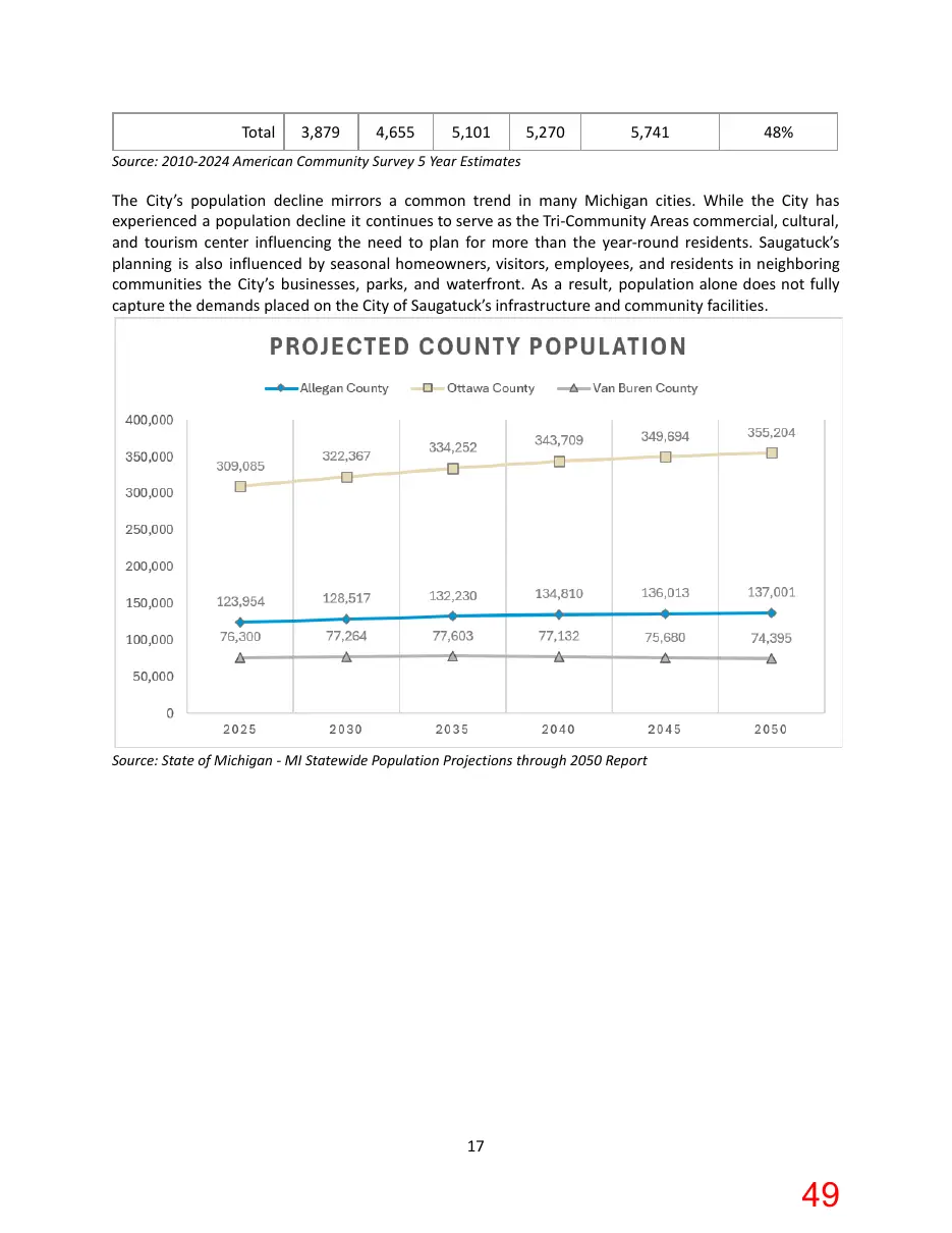
Our People Population Trends The Tri-Community Area has collectively experienced growth from 1990 to 2025, increasing from 3,879 residents in 1990 to an estimated 5,741 residents in 2024 (48% increase). However, due to factors such as available developable land, the growth has not been distributed evenly across the three communities. The City of Saugatuck has overall experienced a gradual decline in population decreasing from 954 residents in 1990 to an estimated 766 residents in 2024 (20% decrease). The City of the Village of Douglas experienced a steady population growth through 2010 before a slight decrease followed by a substantial increase in population in 2024 reaching an estimated 1,427 residents (36% increase from 1990). Saugatuck Township has experienced the most significant growth in the area, nearly doubling their population from 1,876 residents in 1990 to an estimated 3,548 in 2024 (89% increase).
1990
2000
2010
2020
2024 (5-Year Estimate)
1990-2024% Change
City of Saugatuck
1,065
-20%
Douglas City of Village
1,049
1,214
1,232
1,107
1,427
36%
Saugatuck Township
1,876
2,376
2,944
3,298
3,548
89%
Page 49
Text of page 49
Total
3,879
4,655
5,101
5,270
5,741
48%
Source: 2010-2024 American Community Survey 5 Year Estimates
The City’s population decline mirrors a common trend in many Michigan cities. While the City has experienced a population decline it continues to serve as the Tri-Community Areas commercial, cultural, and tourism center influencing the need to plan for more than the year-round residents. Saugatuck’s planning is also influenced by seasonal homeowners, visitors, employees, and residents in neighboring communities the City’s businesses, parks, and waterfront. As a result, population alone does not fully capture the demands placed on the City of Saugatuck’s infrastructure and community facilities.
Source: State of Michigan - MI Statewide Population Projections through 2050 Report
Page 50
Text of page 50
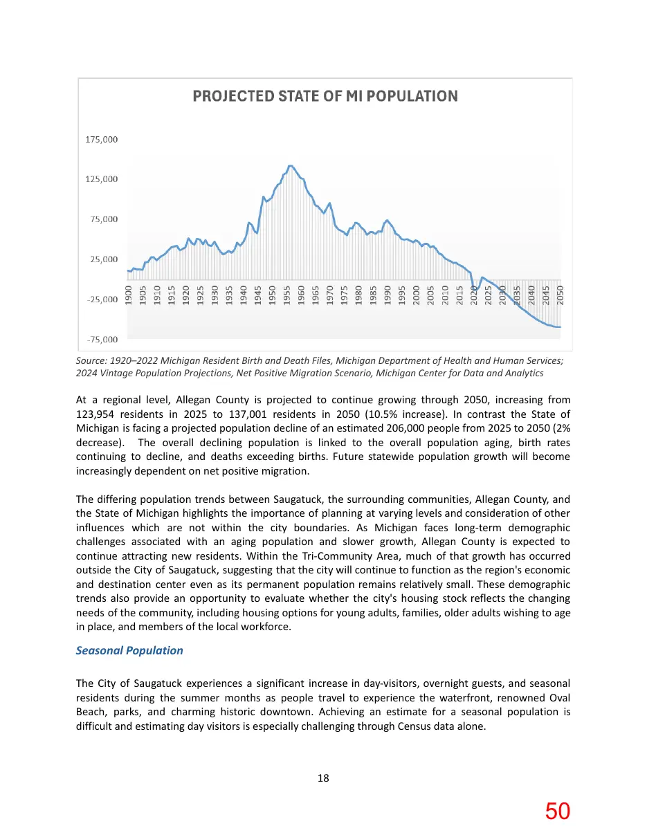
Source: 1920–2022 Michigan Resident Birth and Death Files, Michigan Department of Health and Human Services; 2024 Vintage Population Projections, Net Positive Migration Scenario, Michigan Center for Data and Analytics
At a regional level, Allegan County is projected to continue growing through 2050, increasing from 123,954 residents in 2025 to 137,001 residents in 2050 (10.5% increase). In contrast the State of Michigan is facing a projected population decline of an estimated 206,000 people from 2025 to 2050 (2% decrease). The overall declining population is linked to the overall population aging, birth rates continuing to decline, and deaths exceeding births. Future statewide population growth will become increasingly dependent on net positive migration. The differing population trends between Saugatuck, the surrounding communities, Allegan County, and the State of Michigan highlights the importance of planning at varying levels and consideration of other influences which are not within the city boundaries. As Michigan faces long-term demographic challenges associated with an aging population and slower growth, Allegan County is expected to continue attracting new residents. Within the Tri-Community Area, much of that growth has occurred outside the City of Saugatuck, suggesting that the city will continue to function as the region's economic and destination center even as its permanent population remains relatively small. These demographic trends also provide an opportunity to evaluate whether the city's housing stock reflects the changing needs of the community, including housing options for young adults, families, older adults wishing to age in place, and members of the local workforce.
Seasonal Population The City of Saugatuck experiences a significant increase in day-visitors, overnight guests, and seasonal residents during the summer months as people travel to experience the waterfront, renowned Oval Beach, parks, and charming historic downtown. Achieving an estimate for a seasonal population is difficult and estimating day visitors is especially challenging through Census data alone.
Page 51
Text of page 51
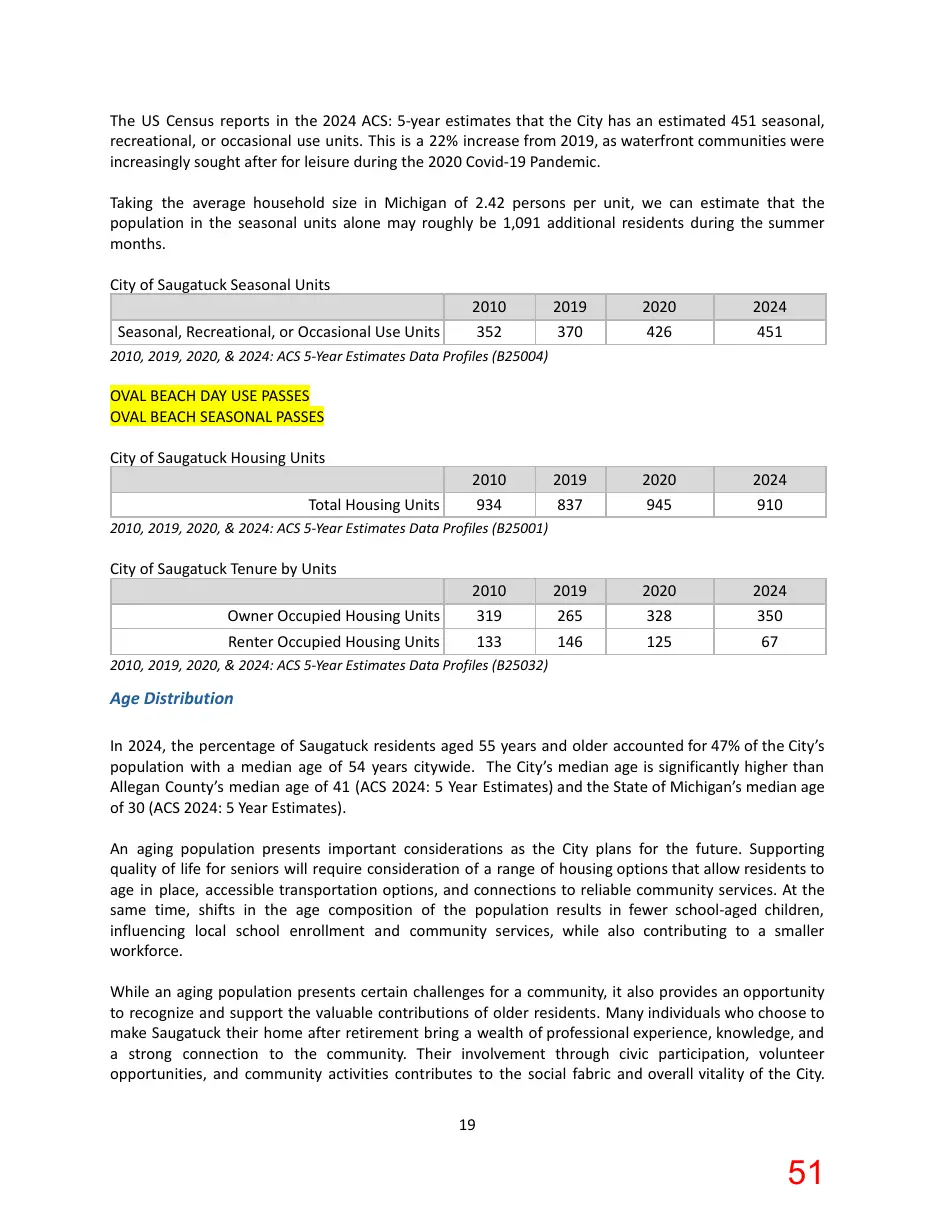
The US Census reports in the 2024 ACS: 5-year estimates that the City has an estimated 451 seasonal, recreational, or occasional use units. This is a 22% increase from 2019, as waterfront communities were increasingly sought after for leisure during the 2020 Covid-19 Pandemic. Taking the average household size in Michigan of 2.42 persons per unit, we can estimate that the population in the seasonal units alone may roughly be 1,091 additional residents during the summer months. City of Saugatuck Seasonal Units Seasonal, Recreational, or Occasional Use Units
2010 352
2019 370
2020 426
2024 451
2019 837
2020 945
2024 910
2019 265 146
2020 328 125
2024 350 67
2010, 2019, 2020, & 2024: ACS 5-Year Estimates Data Profiles (B25004)
OVAL BEACH DAY USE PASSES OVAL BEACH SEASONAL PASSES City of Saugatuck Housing Units Total Housing Units
2010 934
2010, 2019, 2020, & 2024: ACS 5-Year Estimates Data Profiles (B25001)
City of Saugatuck Tenure by Units Owner Occupied Housing Units Renter Occupied Housing Units
2010 319 133
2010, 2019, 2020, & 2024: ACS 5-Year Estimates Data Profiles (B25032)
Age Distribution In 2024, the percentage of Saugatuck residents aged 55 years and older accounted for 47% of the City’s population with a median age of 54 years citywide. The City’s median age is significantly higher than Allegan County’s median age of 41 (ACS 2024: 5 Year Estimates) and the State of Michigan’s median age of 30 (ACS 2024: 5 Year Estimates). An aging population presents important considerations as the City plans for the future. Supporting quality of life for seniors will require consideration of a range of housing options that allow residents to age in place, accessible transportation options, and connections to reliable community services. At the same time, shifts in the age composition of the population results in fewer school-aged children, influencing local school enrollment and community services, while also contributing to a smaller workforce. While an aging population presents certain challenges for a community, it also provides an opportunity to recognize and support the valuable contributions of older residents. Many individuals who choose to make Saugatuck their home after retirement bring a wealth of professional experience, knowledge, and a strong connection to the community. Their involvement through civic participation, volunteer opportunities, and community activities contributes to the social fabric and overall vitality of the City. 19
Page 52

Text of page 52
Recognizing the experience, skills, and commitment of older residents will be an important consideration as Saugatuck plans for the future. City of Saugatuck Population by Age 2010 57
2020 53
2024 54
Median Age 0 to 14 15 to 24 25 to 34 35 to 54 55 to 74
69 67 61 162 344
8% 8% 7% 20% 42%
131 77 51 245 304
14% 9% 6% 27% 34%
102 32 43 227 247
13% 4% 6% 30% 32%
75 years and over Total
118 821
15%
91 899
10%
115 766
15%
2010, 2020, & 2024: ACS 5-Year Estimates Data Profiles (DP05)
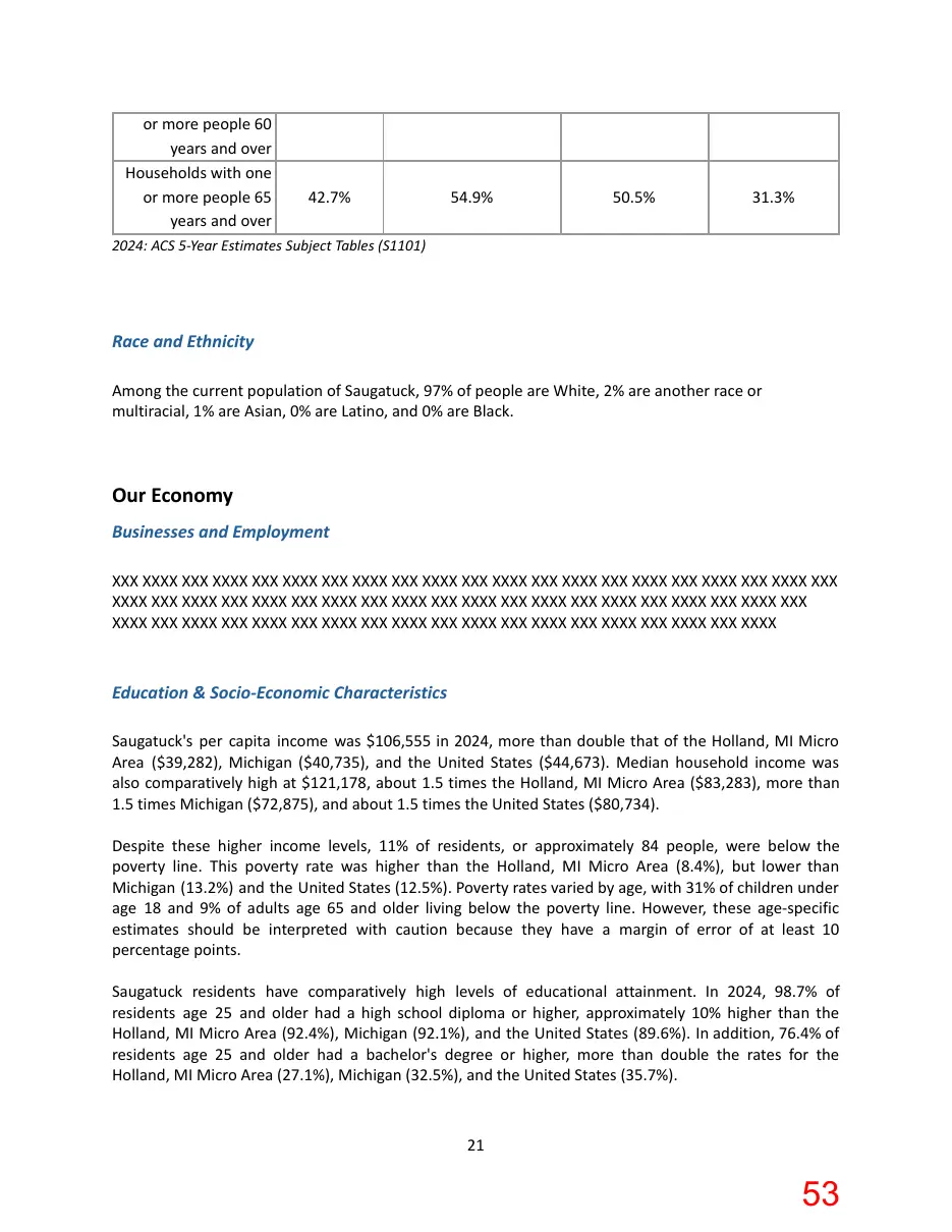
Household Composition In 2024, Saugatuck had 417 households with an average household size of 1.84 persons. This average household size was substantially smaller than the Holland, MI Micro Area (2.6 persons), Michigan (2.4 persons), and the United States (2.5 persons), reflecting the City's relatively large share of smaller households, including retirees, seasonal residents, and oneand two-person households.
Saugatuck City Douglas City of Village Saugatuck Township Total Households Average Household Size Total Families Average Family Size Householder Living Alone 65 Years & Older Living Alone
Allegan County
1,502
127,544,730
1.84
1.93
2.36
2.54
209 2.5
370 2.51
1,084 2.73
82,464,986 3.15
40.8%
39.8%
20%
28.3%
18.5%
24%
12.7%
11.3%
2024: ACS 5-Year Estimates Subject Tables (S1101)
Saugatuck City Douglas City of Village Saugatuck Township
Allegan County
Households with one or more people under 18 years
19.7%
14.4%
19.7%
29.5%
Households with one
54.4%
64.5%
59.5%
41.5%
Page 53
Text of page 53
or more people 60 years and over Households with one or more people 65 years and over
42.7%
54.9%
50.5%
31.3%
2024: ACS 5-Year Estimates Subject Tables (S1101)
Race and Ethnicity Among the current population of Saugatuck, 97% of people are White, 2% are another race or multiracial, 1% are Asian, 0% are Latino, and 0% are Black.
Our Economy Businesses and Employment XXX XXXX XXX XXXX XXX XXXX XXX XXXX XXX XXXX XXX XXXX XXX XXXX XXX XXXX XXX XXXX XXX XXXX XXX XXXX XXX XXXX XXX XXXX XXX XXXX XXX XXXX XXX XXXX XXX XXXX XXX XXXX XXX XXXX XXX XXXX XXX XXXX XXX XXXX XXX XXXX XXX XXXX XXX XXXX XXX XXXX XXX XXXX XXX XXXX XXX XXXX XXX XXXX
Education & Socio-Economic Characteristics Saugatuck's per capita income was $106,555 in 2024, more than double that of the Holland, MI Micro Area ($39,282), Michigan ($40,735), and the United States ($44,673). Median household income was also comparatively high at $121,178, about 1.5 times the Holland, MI Micro Area ($83,283), more than 1.5 times Michigan ($72,875), and about 1.5 times the United States ($80,734). Despite these higher income levels, 11% of residents, or approximately 84 people, were below the poverty line. This poverty rate was higher than the Holland, MI Micro Area (8.4%), but lower than Michigan (13.2%) and the United States (12.5%). Poverty rates varied by age, with 31% of children under age 18 and 9% of adults age 65 and older living below the poverty line. However, these age-specific estimates should be interpreted with caution because they have a margin of error of at least 10 percentage points. Saugatuck residents have comparatively high levels of educational attainment. In 2024, 98.7% of residents age 25 and older had a high school diploma or higher, approximately 10% higher than the Holland, MI Micro Area (92.4%), Michigan (92.1%), and the United States (89.6%). In addition, 76.4% of residents age 25 and older had a bachelor's degree or higher, more than double the rates for the Holland, MI Micro Area (27.1%), Michigan (32.5%), and the United States (35.7%).
Page 54
Text of page 54
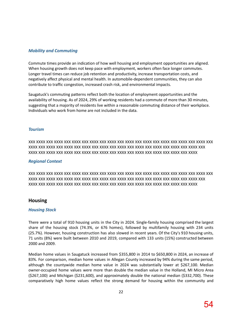
Mobility and Commuting Commute times provide an indication of how well housing and employment opportunities are aligned. When housing growth does not keep pace with employment, workers often face longer commutes. Longer travel times can reduce job retention and productivity, increase transportation costs, and negatively affect physical and mental health. In automobile-dependent communities, they can also contribute to traffic congestion, increased crash risk, and environmental impacts. Saugatuck's commuting patterns reflect both the location of employment opportunities and the availability of housing. As of 2024, 29% of working residents had a commute of more than 30 minutes, suggesting that a majority of residents live within a reasonable commuting distance of their workplace. Individuals who work from home are not included in the data.
Tourism XXX XXXX XXX XXXX XXX XXXX XXX XXXX XXX XXXX XXX XXXX XXX XXXX XXX XXXX XXX XXXX XXX XXXX XXX XXXX XXX XXXX XXX XXXX XXX XXXX XXX XXXX XXX XXXX XXX XXXX XXX XXXX XXX XXXX XXX XXXX XXX XXXX XXX XXXX XXX XXXX XXX XXXX XXX XXXX XXX XXXX XXX XXXX XXX XXXX XXX XXXX XXX XXXX
Regional Context XXX XXXX XXX XXXX XXX XXXX XXX XXXX XXX XXXX XXX XXXX XXX XXXX XXX XXXX XXX XXXX XXX XXXX XXX XXXX XXX XXXX XXX XXXX XXX XXXX XXX XXXX XXX XXXX XXX XXXX XXX XXXX XXX XXXX XXX XXXX XXX XXXX XXX XXXX XXX XXXX XXX XXXX XXX XXXX XXX XXXX XXX XXXX XXX XXXX XXX XXXX XXX XXXX
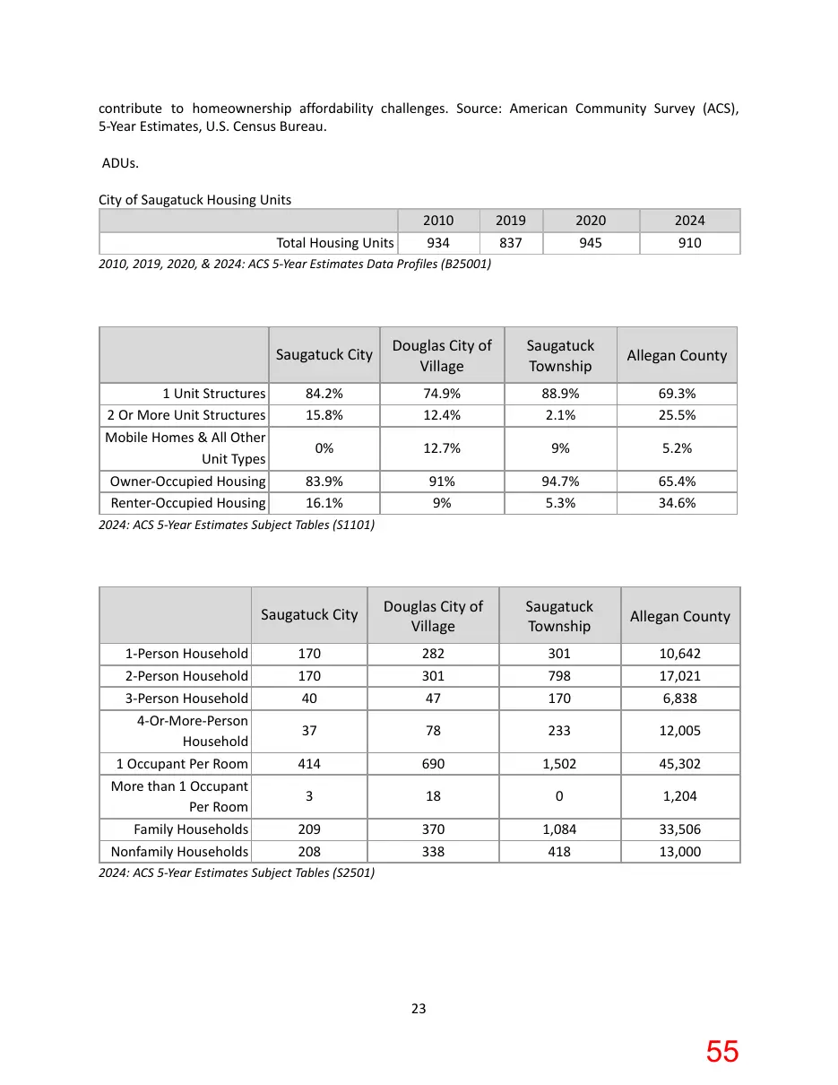
Housing Housing Stock There were a total of 910 housing units in the City in 2024. Single-family housing comprised the largest share of the housing stock (74.3%, or 676 homes), followed by multifamily housing with 234 units (25.7%). However, housing construction has also slowed in recent years. Of the City's 910 housing units, 71 units (8%) were built between 2010 and 2019, compared with 133 units (15%) constructed between 2000 and 2009. Median home values in Saugatuck increased from $355,800 in 2014 to $650,800 in 2024, an increase of 83%. For comparison, median home values in Allegan County increased by 94% during the same period, although the countywide median home value in 2024 was substantially lower at $267,100. Median owner-occupied home values were more than double the median value in the Holland, MI Micro Area ($267,100) and Michigan ($231,600), and approximately double the national median ($332,700). These comparatively high home values reflect the strong demand for housing within the community and 22
Page 55
Text of page 55
contribute to homeownership affordability challenges. Source: American Community Survey (ACS), 5-Year Estimates, U.S. Census Bureau. ADUs. City of Saugatuck Housing Units Total Housing Units
2010 934
2019 837
2020 945
2024 910
2010, 2019, 2020, & 2024: ACS 5-Year Estimates Data Profiles (B25001)
Saugatuck City
Douglas City of Village
Saugatuck Township
Allegan County
84.2% 15.8%
74.9% 12.4%
88.9% 2.1%
69.3% 25.5%
12.7%
5.2%
83.9% 16.1%
91% 9%
94.7% 5.3%
65.4% 34.6%
Saugatuck City
Douglas City of Village
Saugatuck Township
Allegan County
170 170 40
282 301 47
301 798 170
10,642 17,021 6,838
12,005
1,502
45,302
1,204
209 208
370 338
1,084 418
33,506 13,000
1 Unit Structures 2 Or More Unit Structures Mobile Homes & All Other Unit Types Owner-Occupied Housing Renter-Occupied Housing
2024: ACS 5-Year Estimates Subject Tables (S1101)
1-Person Household 2-Person Household 3-Person Household 4-Or-More-Person Household 1 Occupant Per Room More than 1 Occupant Per Room Family Households Nonfamily Households
2024: ACS 5-Year Estimates Subject Tables (S2501)
Page 56
Text of page 56
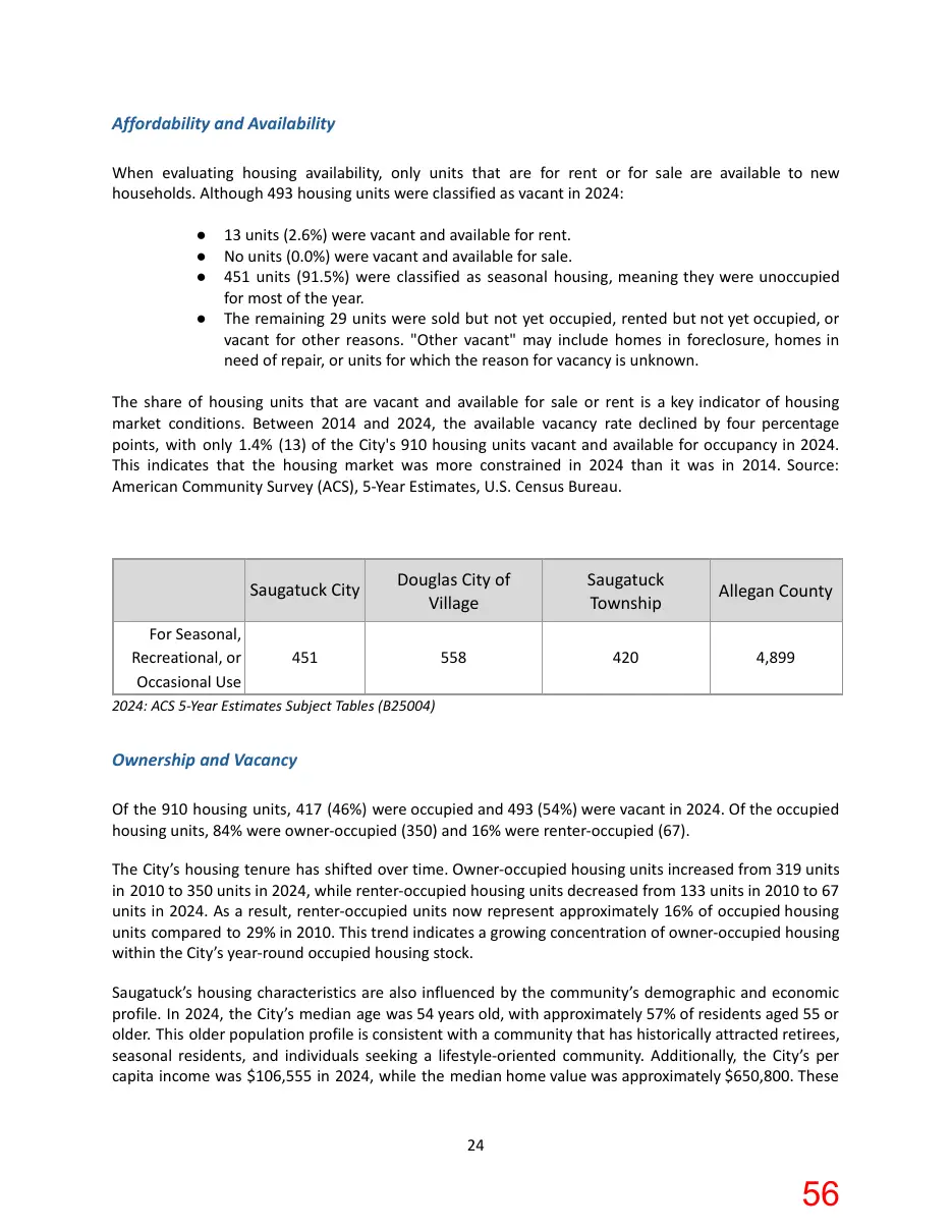
Affordability and Availability When evaluating housing availability, only units that are for rent or for sale are available to new households. Although 493 housing units were classified as vacant in 2024: ● 13 units (2.6%) were vacant and available for rent. ● No units (0.0%) were vacant and available for sale. ● 451 units (91.5%) were classified as seasonal housing, meaning they were unoccupied for most of the year. ● The remaining 29 units were sold but not yet occupied, rented but not yet occupied, or vacant for other reasons. "Other vacant" may include homes in foreclosure, homes in need of repair, or units for which the reason for vacancy is unknown. The share of housing units that are vacant and available for sale or rent is a key indicator of housing market conditions. Between 2014 and 2024, the available vacancy rate declined by four percentage points, with only 1.4% (13) of the City's 910 housing units vacant and available for occupancy in 2024. This indicates that the housing market was more constrained in 2024 than it was in 2014. Source: American Community Survey (ACS), 5-Year Estimates, U.S. Census Bureau.
For Seasonal, Recreational, or Occasional Use
Saugatuck City
Douglas City of Village
Saugatuck Township
Allegan County
4,899
2024: ACS 5-Year Estimates Subject Tables (B25004)
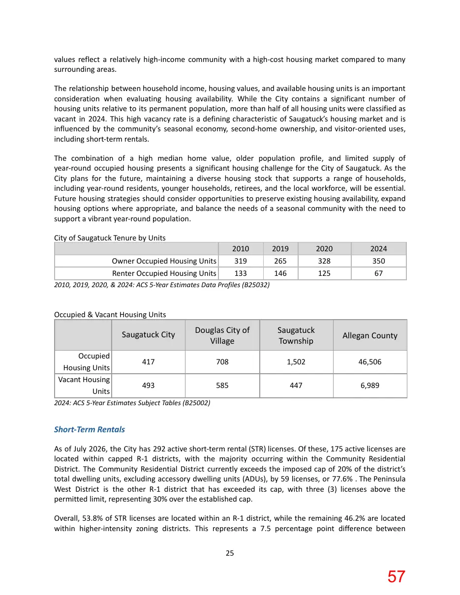
Ownership and Vacancy Of the 910 housing units, 417 (46%) were occupied and 493 (54%) were vacant in 2024. Of the occupied housing units, 84% were owner-occupied (350) and 16% were renter-occupied (67). The City’s housing tenure has shifted over time. Owner-occupied housing units increased from 319 units in 2010 to 350 units in 2024, while renter-occupied housing units decreased from 133 units in 2010 to 67 units in 2024. As a result, renter-occupied units now represent approximately 16% of occupied housing units compared to 29% in 2010. This trend indicates a growing concentration of owner-occupied housing within the City’s year-round occupied housing stock. Saugatuck’s housing characteristics are also influenced by the community’s demographic and economic profile. In 2024, the City’s median age was 54 years old, with approximately 57% of residents aged 55 or older. This older population profile is consistent with a community that has historically attracted retirees, seasonal residents, and individuals seeking a lifestyle-oriented community. Additionally, the City’s per capita income was $106,555 in 2024, while the median home value was approximately $650,800. These
Page 57
Text of page 57
values reflect a relatively high-income community with a high-cost housing market compared to many surrounding areas. The relationship between household income, housing values, and available housing units is an important consideration when evaluating housing availability. While the City contains a significant number of housing units relative to its permanent population, more than half of all housing units were classified as vacant in 2024. This high vacancy rate is a defining characteristic of Saugatuck’s housing market and is influenced by the community’s seasonal economy, second-home ownership, and visitor-oriented uses, including short-term rentals. The combination of a high median home value, older population profile, and limited supply of year-round occupied housing presents a significant housing challenge for the City of Saugatuck. As the City plans for the future, maintaining a diverse housing stock that supports a range of households, including year-round residents, younger households, retirees, and the local workforce, will be essential. Future housing strategies should consider opportunities to preserve existing housing availability, expand housing options where appropriate, and balance the needs of a seasonal community with the need to support a vibrant year-round population. City of Saugatuck Tenure by Units 2010 319 133
Owner Occupied Housing Units Renter Occupied Housing Units
2019 265 146
2020 328 125
2024 350 67
2010, 2019, 2020, & 2024: ACS 5-Year Estimates Data Profiles (B25032)
Occupied & Vacant Housing Units
Saugatuck City
Douglas City of Village
Saugatuck Township
Allegan County
1,502
46,506
6,989
Occupied Housing Units Vacant Housing Units
2024: ACS 5-Year Estimates Subject Tables (B25002)
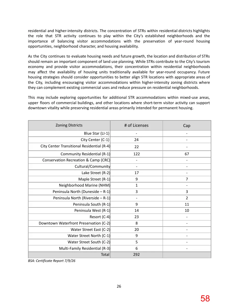
Short-Term Rentals As of July 2026, the City has 292 active short-term rental (STR) licenses. Of these, 175 active licenses are located within capped R-1 districts, with the majority occurring within the Community Residential District. The Community Residential District currently exceeds the imposed cap of 20% of the district’s total dwelling units, excluding accessory dwelling units (ADUs), by 59 licenses, or 77.6% . The Peninsula West District is the other R-1 district that has exceeded its cap, with three (3) licenses above the permitted limit, representing 30% over the established cap. Overall, 53.8% of STR licenses are located within an R-1 district, while the remaining 46.2% are located within higher-intensity zoning districts. This represents a 7.5 percentage point difference between 25
Page 58
Text of page 58
residential and higher-intensity districts. The concentration of STRs within residential districts highlights the role that STR activity continues to play within the City’s established neighborhoods and the importance of balancing visitor accommodations with the preservation of year-round housing opportunities, neighborhood character, and housing availability. As the City continues to evaluate housing needs and future growth, the location and distribution of STRs should remain an important component of land use planning. While STRs contribute to the City’s tourism economy and provide visitor accommodations, their concentration within residential neighborhoods may affect the availability of housing units traditionally available for year-round occupancy. Future housing strategies should consider opportunities to better align STR locations with appropriate areas of the City, including encouraging visitor accommodations within higher-intensity zoning districts where they can complement existing commercial uses and reduce pressure on residential neighborhoods. This may include exploring opportunities for additional STR accommodations within mixed-use areas, upper floors of commercial buildings, and other locations where short-term visitor activity can support downtown vitality while preserving residential areas primarily intended for permanent housing.
# of Licenses
Cap
Blue Star (LI-1) City Center (C-1) City Center Transitional Residential (R-4)
Community Residential (R-1) Conservation Recreation & Camp (CRC) Cultural/Community Lake Street (R-2) Maple Street (R-1) Neighborhood Marine (NHM) Peninsula North (Duneside – R-1) Peninsula North (Riverside – R-1) Peninsula South (R-1) Peninsula West (R-1) Resort (C-4) Downtown Waterfront Preservation (C-2) Water Street East (C-2) Water Street North (C-1) Water Street South (C-2) Multi-Family Residential (R-3) Total
122 17 9 1 3 9 14 23 8 20 9 5 6 292
67 7 3 2 11 10 -
Zoning DIstricts
BSA: Certificate Report 7/9/26
Page 59
Text of page 59
Conclusion Understanding the City's history, community perspectives, demographic characteristics, and housing and economic conditions provides the foundation for sound planning decisions. Together, these topics establish the context needed to identify community needs, evaluate opportunities and constraints, and develop recommendations in the upcoming chapters that are both responsive to existing conditions and consistent with the community's long-term vision.
Page 60
Text of page 60
Chapter 3: Community Character Introduction and Goal This chapter examines the physical character, identity, and sense of place that define the City of Saugatuck. Community character is shaped not only by land use but also by the relationships among buildings, streets, neighborhoods, waterfronts, natural features, and public spaces that collectively create the City's unique identity. Understanding these characteristics provides the foundation for future land use planning, urban design, historic preservation, and policy decisions that seek to preserve what makes Saugatuck distinctive while accommodating thoughtful change. This chapter includes a character analysis, an existing land use assessment, and a discussion of urban design, transitional areas, gateways, wayfinding, and historic preservation to establish a framework for maintaining and enhancing the community's character over time. 1. Option 1 Goal: Preserve and enhance Saugatuck's unique community character by protecting its historic resources, waterfront setting, natural environment, and established neighborhoods while guiding compatible growth, redevelopment, and public investment that reinforces the City's distinctive sense of place. 2. Option 2 Goal: Preserve and strengthen the physical character and sense of place that make Saugatuck unique while ensuring that future growth and redevelopment are compatible with the community's established identity. 3. Option 3 Goal: Guide future land use, development, and public improvements in a manner that reinforces Saugatuck's historic character, walkability, neighborhood identity, waterfront, and natural landscape. 4. Option 4 Goal: Maintain and enhance the distinct character of Saugatuck's neighborhoods, downtown, waterfront, and natural areas by ensuring that future planning and development respect the qualities that define each planning area and character district. 5. Option 5 Goal: Promote thoughtful growth and reinvestment that preserves Saugatuck's small-town character, protects historic and natural resources, strengthens neighborhood transitions, and enhances the community's identity for residents and visitors. 6. Option 6 Goal: Preserve, enhance, and celebrate the distinctive character of Saugatuck by protecting its historic downtown, established neighborhoods, waterfronts, and natural landscapes while guiding future land use, development, and public improvements that are compatible with the City's unique sense of place.
Character Analysis Intent The City Community Character Analysis is intended to better understand the unique qualities of the City and its neighborhoods in ways that a traditional existing land use map alone cannot capture. Rather than serving as a simple inventory of land uses, the analysis evaluates the physical and functional characteristics that define districts, neighborhoods, and corridors, including development scale, block
Page 61
Text of page 61
and lot patterns, street and sidewalk networks, pathways, parking, building types, and land use relationships. This approach serves as a basis for identifying areas to preserve, enhance, or thoughtfully transform, and will provide a stronger foundation for future land use recommendations and zoning policy decisions. The intent was to identify what makes areas similar or different based on real-world characteristics rather than regulatory boundaries. Ultimately, the character analysis is intended to ensure that future growth and development align with Saugatuck’s established character and community context. To better understand the City’s physical form and development patterns, the community has been divided into character areas. These areas represent distinct parts of the City that share common patterns in land use, development intensity, built form, and environmental context. This analysis serves several purposes: ▪
Classifies areas based on common characteristics, including land use, zoning, density, intensity, infrastructure, and utilities, and helps to define a sense of place.
Establishes a clear and simplified framework for future growth and land use planning.
Provides justification for future land use recommendations and distinctions between different parts of the City.
Each character area is evaluated using the following components: ▪
Buildings: Predominant building types, setbacks, architectural character, and general form.
Land Use: Primary and supporting uses within the area.
Scale: Building height, massing, and overall development intensity.
Blocks and Streets: Block patterns, street layout (grid, curvilinear, etc.), and connectivity.
Streetscape: Sidewalks, street trees, lighting, and pedestrian environment.
Public Space: Parks, plazas, waterfront access, and civic spaces.
Parking: On-street and off-street parking patterns and visibility.
Walkability: Distance from downtown and ease of pedestrian travel.
Planning Areas The City has been organized into three primary planning areas, each containing multiple distinct character areas. This structure is intended to provide a clear, manageable framework for understanding and evaluating the City from a planning perspective. By grouping character areas within broader 29
Page 62
Text of page 62
planning areas, the analysis can focus on both larger geographic patterns and the finer-grained distinctions between neighborhoods, districts, and corridors. ▪
Central City o Central Downtown Activity Center o Downtown Waterfront Commercial o Downtown Neighborhood Mixed-Use o Transitional Residential o Central City Residential
East Side Neighborhoods o Traditional Neighborhood Residential o North Riverfront Residential o South Riverfront Mixed Residential o North Marina/Harbor Services Area o South Hillside Residential o Suburban/Rural Fringe Residential
Coastal Dunes and Peninsula o West Riverfront Residential o Coastal Dune Residential
The planning areas reflect natural divisions within the community, shaped by geography, waterfront features, transportation patterns, and the overall arrangement of development. This approach allows for a more organized and practical assessment of existing conditions, ensuring that major portions of the City can be evaluated cohesively while still recognizing the unique characteristics that define smaller areas within each planning area.
Page 63
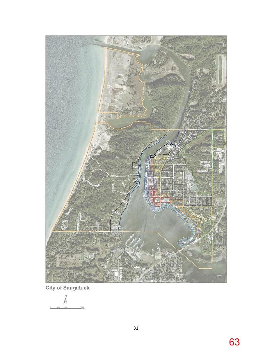
This page is a scanned image with no text layer. The PDF of these pages has it at full resolution.
Page 64
Text of page 64
Planning Area One: Central City This area represents the heart of Saugatuck and contains the highest concentration of commercial activity, tourism destinations, civic uses, and walkable neighborhoods. It is defined by a compact development pattern, strong pedestrian orientation, and direct access to the waterfront. Central Downtown Activity Center The Central Downtown Activity Center represents the historic and functional core of the City and serves as its primary center of activity. It is characterized by a cohesive pattern of traditional downtown buildings that define a continuous street edge and support an active, pedestrian-oriented environment. A mix of commercial, civic, and entertainment uses contributes to a vibrant atmosphere. This area serves as the focal point for daily activities, tourism, and community gatherings. Butler and Culver Streets serve as the focal points of the character area. The area is characterized by a cohesive pattern of oneto two-story traditional downtown buildings, many of which are contributing resources within the Historic District, forming a largely continuous “street wall” of buildings from Culver Street to Hoffman Street. In this area, buildings are commonly attached or detached with minimal separations, reinforcing a highly active, pedestrian-oriented environment. However, while the area is predominantly defined by attached storefronts or buildings drawn closer to the right-of-way, the presence of house-scale detached buildings contributes to an eclectic, varied character. This Central Downtown Activity Center is supported by wide sidewalks that extend from building facades to the curb, mature street trees, and streetscape elements such as bike racks, garbage receptacles, and clearly marked crosswalks. ▪
Buildings: Traditional historic storefronts drawn close to the street; attached buildings or those with minimal setbacks, with some house-scale detached buildings interspersed
Land Use: Retail, offices, restaurants, taverns, entertainment, services, and civic uses
Scale: 1–2 story buildings, occasionally 2.5; compact and continuous at a higher intensity
Blocks and Streets: Traditional street grid with strong connectivity
Streetscape: Wide sidewalks, wayfinding signage, outdoor dining areas, street trees, bike racks, planter boxes, public art, benches, hatched crosswalks, standard street lighting (some decorative), and overhead powerlines
Public Space: Civic spaces, City Hall
Parking: On-street parking on both sides of the streets and two public parking lots with 122 spaces
Page 65
Text of page 65
Walkability: 0-5 minute walk throughout the Central Downtown Activity Center with a mostly complete network of sidewalks
Central Downtown Activity Center
Page 66
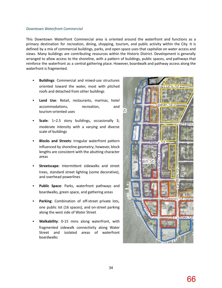
Text of page 66
Downtown Waterfront Commercial This Downtown Waterfront Commercial area is oriented around the waterfront and functions as a primary destination for recreation, dining, shopping, tourism, and public activity within the City. It is defined by a mix of commercial buildings, parks, and open space uses that capitalize on water access and views. Many buildings are contributing resources within the Historic District. Development is generally arranged to allow access to the shoreline, with a pattern of buildings, public spaces, and pathways that reinforce the waterfront as a central gathering place. However, boardwalk and pathway access along the waterfront is fragmented. ▪
Buildings: Commercial and mixed-use structures oriented toward the water, most with pitched roofs and detached from other buildings
Land Use: Retail, restaurants, marinas, hotel accommodations, tourism-oriented uses
recreation,
and
Scale: 1–2.5 story buildings, occasionally 3; moderate intensity with a varying and diverse scale of buildings
Blocks and Streets: Irregular waterfront pattern influenced by shoreline geometry; however, block lengths are consistent with the abutting character areas
Streetscape: Intermittent sidewalks and street trees, standard street lighting (some decorative), and overhead powerlines
Public Space: Parks, waterfront pathways and boardwalks, green space, and gathering areas
Parking: Combination of off-street private lots, one public lot (16 spaces), and on-street parking along the west side of Water Street
Walkability: 0-15 mins along waterfront, with fragmented sidewalk connectivity along Water Street and isolated areas of waterfront boardwalks
Page 67

Text of page 67
Downtown Waterfront Commercial
Page 68
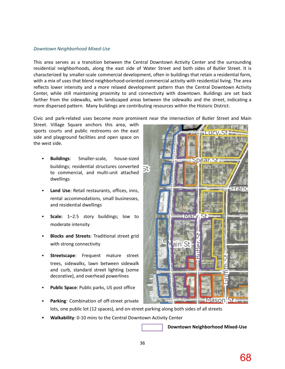
Text of page 68
Downtown Neighborhood Mixed-Use This area serves as a transition between the Central Downtown Activity Center and the surrounding residential neighborhoods, along the east side of Water Street and both sides of Butler Street. It is characterized by smaller-scale commercial development, often in buildings that retain a residential form, with a mix of uses that blend neighborhood-oriented commercial activity with residential living. The area reflects lower intensity and a more relaxed development pattern than the Central Downtown Activity Center, while still maintaining proximity to and connectivity with downtown. Buildings are set back farther from the sidewalks, with landscaped areas between the sidewalks and the street, indicating a more dispersed pattern. Many buildings are contributing resources within the Historic District. Civic and park-related uses become more prominent near the intersection of Butler Street and Main Street. Village Square anchors this area, with sports courts and public restrooms on the east side and playground facilities and open space on the west side. ▪
Buildings:
Smaller-scale,
house-sized
buildings; residential structures converted to commercial, and multi-unit attached dwellings ▪
Land Use: Retail restaurants, offices, inns, rental accommodations, small businesses, and residential dwellings
Scale: 1–2.5 story buildings; low to moderate intensity
Blocks and Streets: Traditional street grid with strong connectivity
Streetscape:
Frequent
mature
street
trees, sidewalks, lawn between sidewalk and curb, standard street lighting (some decorative), and overhead powerlines ▪
Public Space: Public parks, US post office
Parking: Combination of off-street private lots, one public lot (12 spaces), and on-street parking along both sides of all streets
Walkability: 0-10 mins to the Central Downtown Activity Center
Downtown Neighborhood Mixed-Use
Page 69
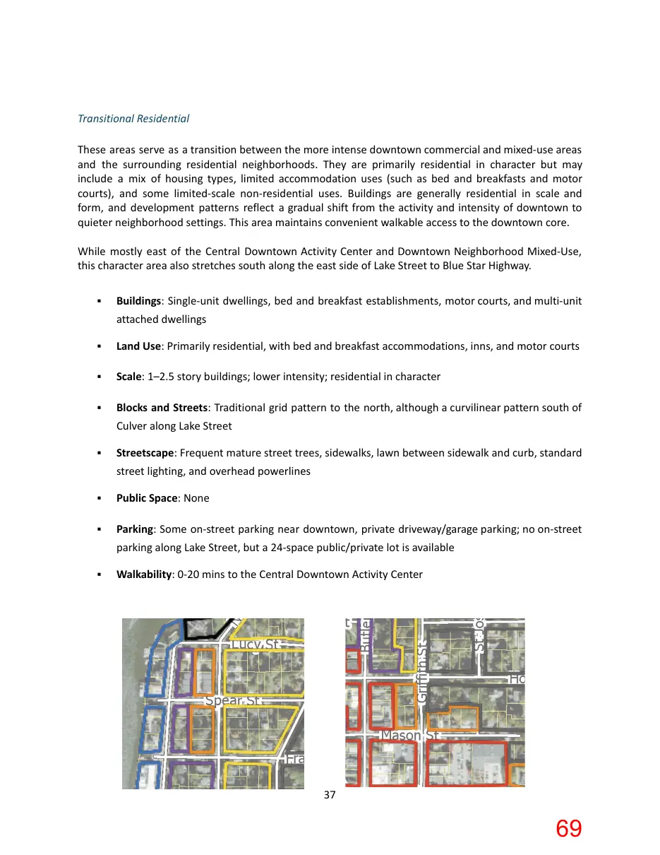
Text of page 69
Transitional Residential These areas serve as a transition between the more intense downtown commercial and mixed-use areas and the surrounding residential neighborhoods. They are primarily residential in character but may include a mix of housing types, limited accommodation uses (such as bed and breakfasts and motor courts), and some limited-scale non-residential uses. Buildings are generally residential in scale and form, and development patterns reflect a gradual shift from the activity and intensity of downtown to quieter neighborhood settings. This area maintains convenient walkable access to the downtown core. While mostly east of the Central Downtown Activity Center and Downtown Neighborhood Mixed-Use, this character area also stretches south along the east side of Lake Street to Blue Star Highway. ▪
Buildings: Single-unit dwellings, bed and breakfast establishments, motor courts, and multi-unit attached dwellings
Land Use: Primarily residential, with bed and breakfast accommodations, inns, and motor courts
Scale: 1–2.5 story buildings; lower intensity; residential in character
Blocks and Streets: Traditional grid pattern to the north, although a curvilinear pattern south of Culver along Lake Street
Streetscape: Frequent mature street trees, sidewalks, lawn between sidewalk and curb, standard street lighting, and overhead powerlines
Public Space: None
Parking: Some on-street parking near downtown, private driveway/garage parking; no on-street parking along Lake Street, but a 24-space public/private lot is available
Walkability: 0-20 mins to the Central Downtown Activity Center
Page 70
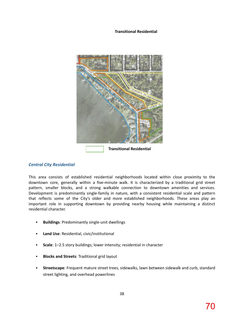
Text of page 70
Transitional Residential
Transitional Residential
Central City Residential This area consists of established residential neighborhoods located within close proximity to the downtown core, generally within a five-minute walk. It is characterized by a traditional grid street pattern, smaller blocks, and a strong walkable connection to downtown amenities and services. Development is predominantly single-family in nature, with a consistent residential scale and pattern that reflects some of the City’s older and more established neighborhoods. These areas play an important role in supporting downtown by providing nearby housing while maintaining a distinct residential character. ▪
Buildings: Predominantly single-unit dwellings
Land Use: Residential, civic/institutional
Scale: 1–2.5 story buildings; lower intensity; residential in character
Blocks and Streets: Traditional grid layout
Streetscape: Frequent mature street trees, sidewalks, lawn between sidewalk and curb, standard street lighting, and overhead powerlines
Page 71
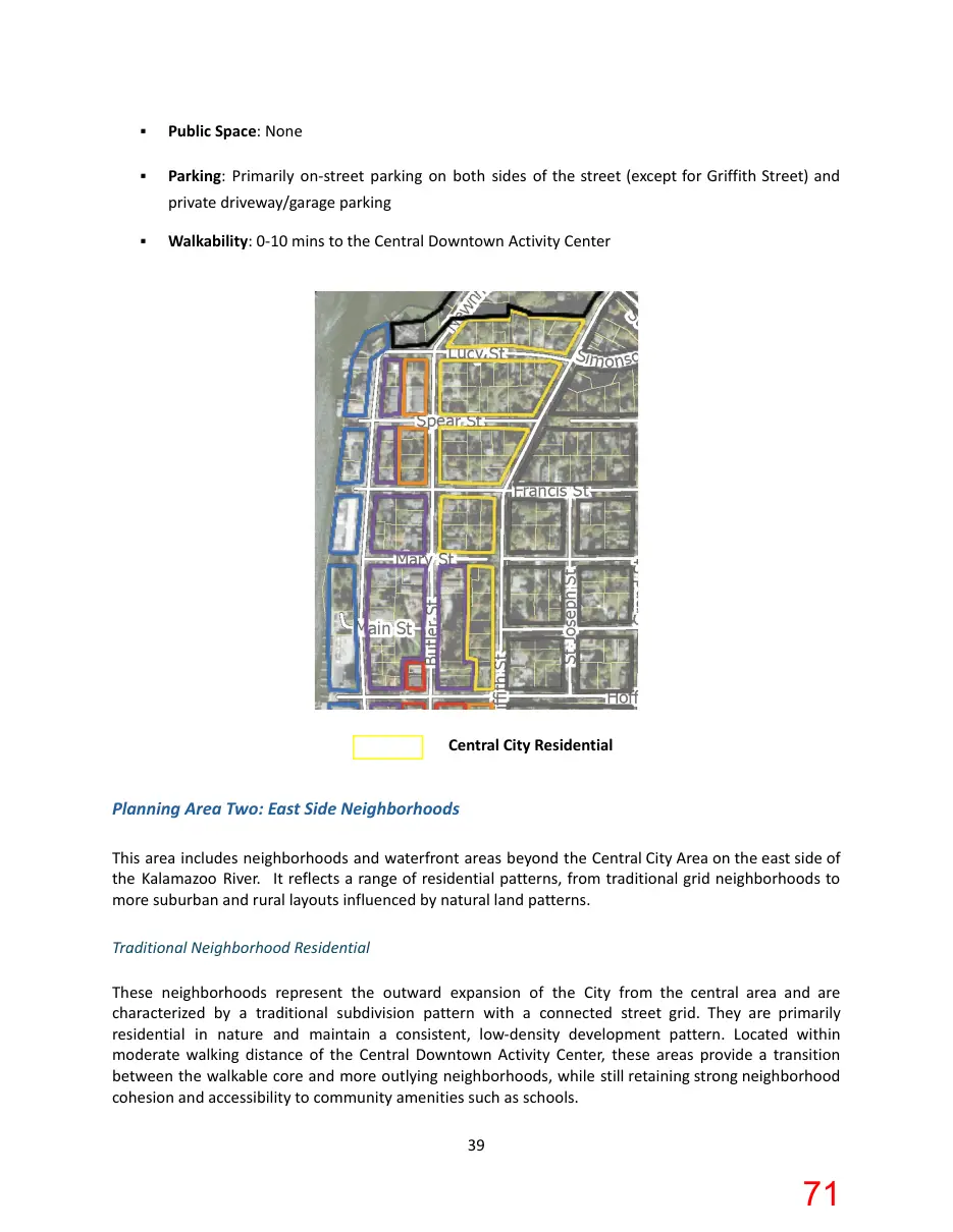
Text of page 71
Public Space: None
Parking: Primarily on-street parking on both sides of the street (except for Griffith Street) and private driveway/garage parking
Walkability: 0-10 mins to the Central Downtown Activity Center
Central City Residential
Planning Area Two: East Side Neighborhoods This area includes neighborhoods and waterfront areas beyond the Central City Area on the east side of the Kalamazoo River. It reflects a range of residential patterns, from traditional grid neighborhoods to more suburban and rural layouts influenced by natural land patterns. Traditional Neighborhood Residential These neighborhoods represent the outward expansion of the City from the central area and are characterized by a traditional subdivision pattern with a connected street grid. They are primarily residential in nature and maintain a consistent, low-density development pattern. Located within moderate walking distance of the Central Downtown Activity Center, these areas provide a transition between the walkable core and more outlying neighborhoods, while still retaining strong neighborhood cohesion and accessibility to community amenities such as schools. 39
Page 72
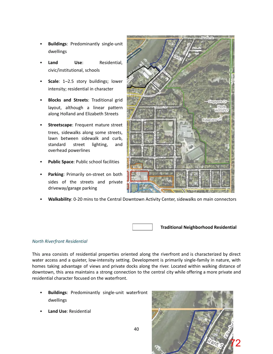
Text of page 72
Buildings: Predominantly single-unit dwellings
Land
Use:
Residential,
civic/institutional, schools ▪
Scale: 1–2.5 story buildings; lower intensity; residential in character
Blocks and Streets: Traditional grid layout, although a linear pattern along Holland and Elizabeth Streets
Streetscape: Frequent mature street trees, sidewalks along some streets, lawn between sidewalk and curb, standard street lighting, and overhead powerlines
Public Space: Public school facilities
Parking: Primarily on-street on both sides of the streets and private driveway/garage parking
Walkability: 0-20 mins to the Central Downtown Activity Center, sidewalks on main connectors
Traditional Neighborhood Residential North Riverfront Residential This area consists of residential properties oriented along the riverfront and is characterized by direct water access and a quieter, low-intensity setting. Development is primarily single-family in nature, with homes taking advantage of views and private docks along the river. Located within walking distance of downtown, this area maintains a strong connection to the central city while offering a more private and residential character focused on the waterfront. ▪
Buildings: Predominantly single-unit waterfront dwellings
Land Use: Residential
Page 73
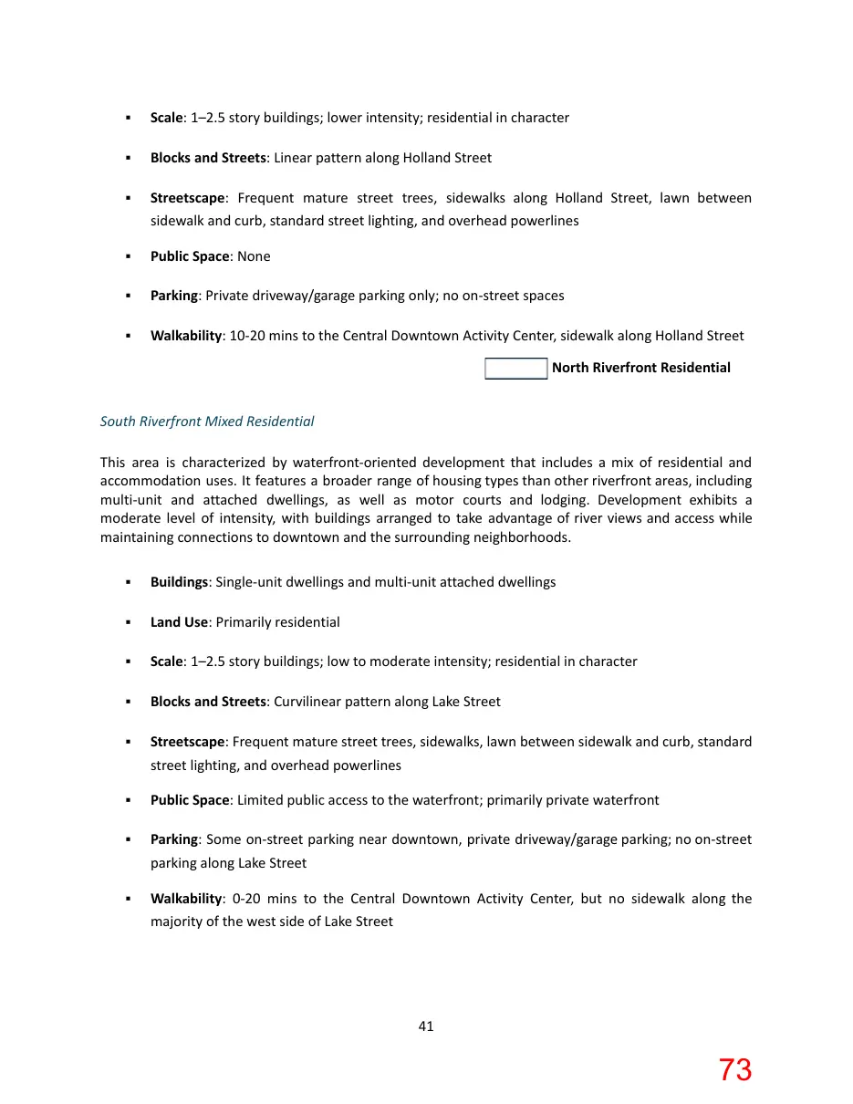
Text of page 73
Scale: 1–2.5 story buildings; lower intensity; residential in character
Blocks and Streets: Linear pattern along Holland Street
Streetscape: Frequent mature street trees, sidewalks along Holland Street, lawn between sidewalk and curb, standard street lighting, and overhead powerlines
Public Space: None
Parking: Private driveway/garage parking only; no on-street spaces
Walkability: 10-20 mins to the Central Downtown Activity Center, sidewalk along Holland Street North Riverfront Residential
South Riverfront Mixed Residential This area is characterized by waterfront-oriented development that includes a mix of residential and accommodation uses. It features a broader range of housing types than other riverfront areas, including multi-unit and attached dwellings, as well as motor courts and lodging. Development exhibits a moderate level of intensity, with buildings arranged to take advantage of river views and access while maintaining connections to downtown and the surrounding neighborhoods. ▪
Buildings: Single-unit dwellings and multi-unit attached dwellings
Land Use: Primarily residential
Scale: 1–2.5 story buildings; low to moderate intensity; residential in character
Blocks and Streets: Curvilinear pattern along Lake Street
Streetscape: Frequent mature street trees, sidewalks, lawn between sidewalk and curb, standard street lighting, and overhead powerlines
Public Space: Limited public access to the waterfront; primarily private waterfront
Parking: Some on-street parking near downtown, private driveway/garage parking; no on-street parking along Lake Street
Walkability: 0-20 mins to the Central Downtown Activity Center, but no sidewalk along the majority of the west side of Lake Street
Page 74
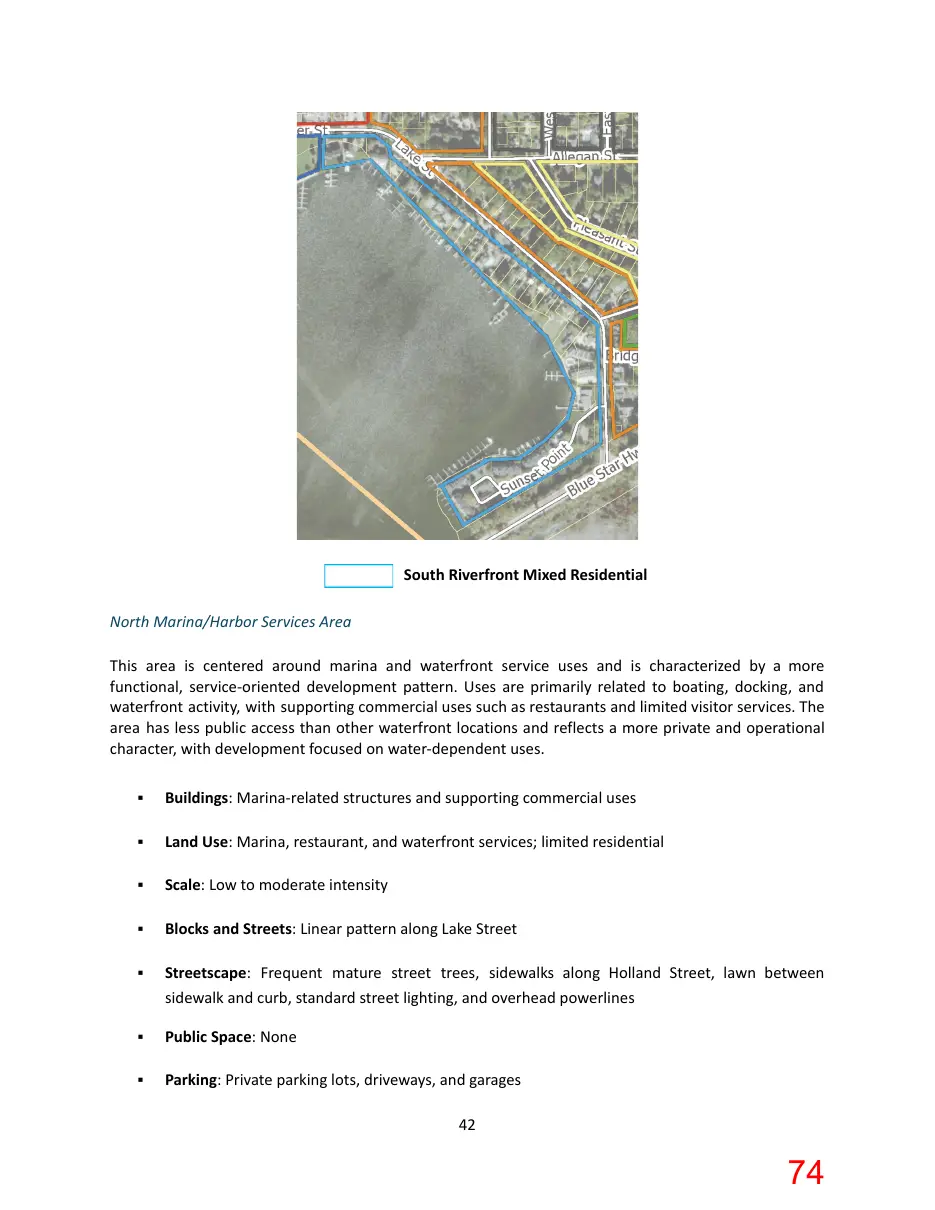
Text of page 74
South Riverfront Mixed Residential North Marina/Harbor Services Area This area is centered around marina and waterfront service uses and is characterized by a more functional, service-oriented development pattern. Uses are primarily related to boating, docking, and waterfront activity, with supporting commercial uses such as restaurants and limited visitor services. The area has less public access than other waterfront locations and reflects a more private and operational character, with development focused on water-dependent uses. ▪
Buildings: Marina-related structures and supporting commercial uses
Land Use: Marina, restaurant, and waterfront services; limited residential
Scale: Low to moderate intensity
Blocks and Streets: Linear pattern along Lake Street
Streetscape: Frequent mature street trees, sidewalks along Holland Street, lawn between sidewalk and curb, standard street lighting, and overhead powerlines
Public Space: None
Parking: Private parking lots, driveways, and garages 42
Page 75
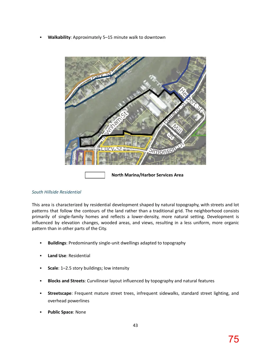
Text of page 75
Walkability: Approximately 5–15 minute walk to downtown
North Marina/Harbor Services Area
South Hillside Residential This area is characterized by residential development shaped by natural topography, with streets and lot patterns that follow the contours of the land rather than a traditional grid. The neighborhood consists primarily of single-family homes and reflects a lower-density, more natural setting. Development is influenced by elevation changes, wooded areas, and views, resulting in a less uniform, more organic pattern than in other parts of the City. ▪
Buildings: Predominantly single-unit dwellings adapted to topography
Land Use: Residential
Scale: 1–2.5 story buildings; low intensity
Blocks and Streets: Curvilinear layout influenced by topography and natural features
Streetscape: Frequent mature street trees, infrequent sidewalks, standard street lighting, and overhead powerlines
Public Space: None 43
Page 76
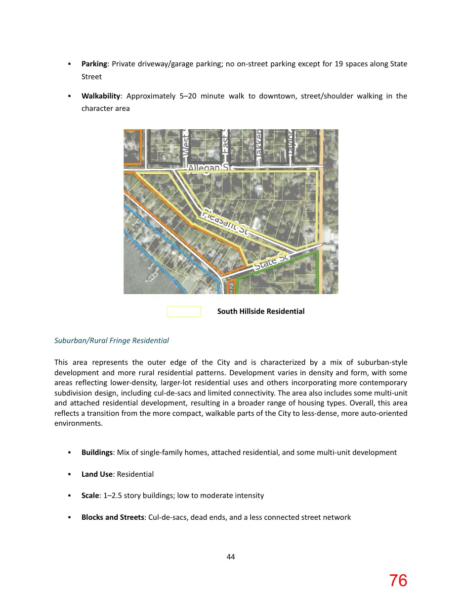
Text of page 76
Parking: Private driveway/garage parking; no on-street parking except for 19 spaces along State Street
Walkability: Approximately 5–20 minute walk to downtown, street/shoulder walking in the character area
South Hillside Residential
Suburban/Rural Fringe Residential This area represents the outer edge of the City and is characterized by a mix of suburban-style development and more rural residential patterns. Development varies in density and form, with some areas reflecting lower-density, larger-lot residential uses and others incorporating more contemporary subdivision design, including cul-de-sacs and limited connectivity. The area also includes some multi-unit and attached residential development, resulting in a broader range of housing types. Overall, this area reflects a transition from the more compact, walkable parts of the City to less-dense, more auto-oriented environments. ▪
Buildings: Mix of single-family homes, attached residential, and some multi-unit development
Land Use: Residential
Scale: 1–2.5 story buildings; low to moderate intensity
Blocks and Streets: Cul-de-sacs, dead ends, and a less connected street network
Page 77
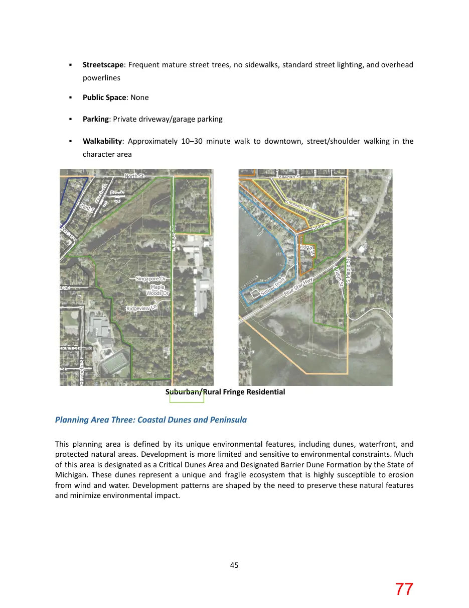
Text of page 77
Streetscape: Frequent mature street trees, no sidewalks, standard street lighting, and overhead powerlines
Public Space: None
Parking: Private driveway/garage parking
Walkability: Approximately 10–30 minute walk to downtown, street/shoulder walking in the character area
Suburban/Rural Fringe Residential
Planning Area Three: Coastal Dunes and Peninsula This planning area is defined by its unique environmental features, including dunes, waterfront, and protected natural areas. Development is more limited and sensitive to environmental constraints. Much of this area is designated as a Critical Dunes Area and Designated Barrier Dune Formation by the State of Michigan. These dunes represent a unique and fragile ecosystem that is highly susceptible to erosion from wind and water. Development patterns are shaped by the need to preserve these natural features and minimize environmental impact.
Page 78
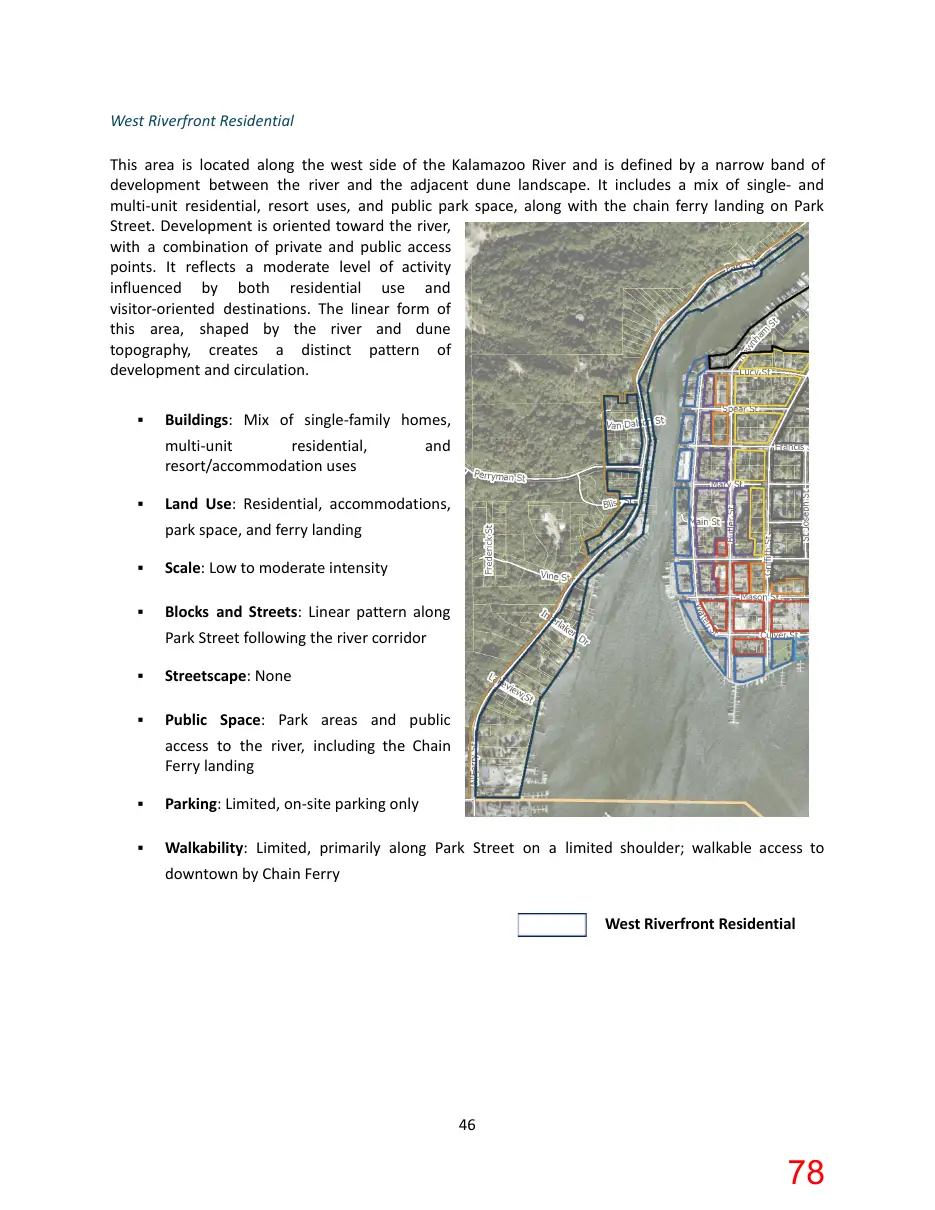
Text of page 78
West Riverfront Residential This area is located along the west side of the Kalamazoo River and is defined by a narrow band of development between the river and the adjacent dune landscape. It includes a mix of singleand multi-unit residential, resort uses, and public park space, along with the chain ferry landing on Park Street. Development is oriented toward the river, with a combination of private and public access points. It reflects a moderate level of activity influenced by both residential use and visitor-oriented destinations. The linear form of this area, shaped by the river and dune topography, creates a distinct pattern of development and circulation. ▪
Buildings: Mix of single-family homes, multi-unit residential, resort/accommodation uses
and
Land Use: Residential, accommodations, park space, and ferry landing
Scale: Low to moderate intensity
Blocks and Streets: Linear pattern along Park Street following the river corridor
Streetscape: None
Public Space: Park areas and public access to the river, including the Chain Ferry landing
Parking: Limited, on-site parking only
Walkability: Limited, primarily along Park Street on a limited shoulder; walkable access to downtown by Chain Ferry West Riverfront Residential
Page 79
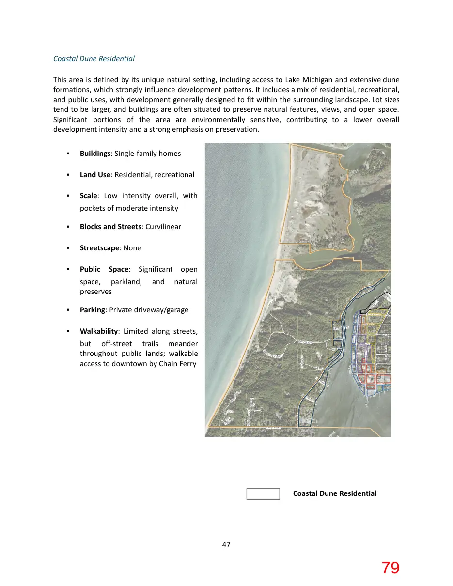
Text of page 79
Coastal Dune Residential This area is defined by its unique natural setting, including access to Lake Michigan and extensive dune formations, which strongly influence development patterns. It includes a mix of residential, recreational, and public uses, with development generally designed to fit within the surrounding landscape. Lot sizes tend to be larger, and buildings are often situated to preserve natural features, views, and open space. Significant portions of the area are environmentally sensitive, contributing to a lower overall development intensity and a strong emphasis on preservation. ▪
Buildings: Single-family homes
Land Use: Residential, recreational
Scale: Low intensity overall, with pockets of moderate intensity
Blocks and Streets: Curvilinear
Streetscape: None
Public
Space: Significant open
space, parkland, preserves
and
natural
Parking: Private driveway/garage
Walkability: Limited along streets, but off-street trails meander throughout public lands; walkable access to downtown by Chain Ferry
Coastal Dune Residential
Page 80
Text of page 80
Existing Land Use An existing land use map illustrates the current use of land based on property classifications from the assessor's office. While these classifications are relatively broad and limited to general categories such as residential, commercial, industrial, parks, and open space, the map provides an important overview of existing development patterns. In particular, it identifies the boundaries between residential and non-residential areas, which help inform future land-use designations and zoning decisions. Unlike the character analysis, the existing land use map focuses solely on current land use. It does not reflect the broader physical, historic, or functional characteristics that distinguish individual neighborhoods and planning areas. As it relates to future land use planning, recognizing the existing land use map does not necessarily mean that future land use or zoning should mirror the existing land use map. Rather, understanding existing conditions helps identify where change may be appropriate and where future land use designations may differ from current development patterns. This will help assess the impact and the extent of future change.
Urban Design and Sense of Place Small-Town Community Character The City of Saugatuck is characterized by a compact, walkable downtown with a high concentration of commercial activity, tourism destinations, civic uses, and direct access to the waterfront. Beyond the central city area, neighborhoods on the east side of the Kalamazoo River include a range of residential patterns, from traditional grid neighborhoods to more suburban and rural layouts influenced by natural land patterns. To the west of the Kalamazoo River, the City's coastal dunes, waterfront, and protected natural areas further define its character, with residential areas significantly influenced by environmental characteristics of the land. Although these three areas are unique, they each contribute to the City’s sense of place. The community survey found that Saugatuck's small-town character is the primary reason residents choose to live in the City, cited by 59.81% (189 of 316) of respondents. When asked what defines that small-town character, 57.27% (193 of 337) of participants identified the walkable downtown, 37.39% (126 of 337) identified the availability of locally owned businesses, and 31.75% (107 of 337) identified the city's arts and cultural offerings as the most important characteristics.
Building Form Based on the character analysis, the City’s building form is defined by a progression from a compact, traditional downtown to lower-density residential neighborhoods and environmentally sensitive 48
Page 81
Text of page 81
waterfront and dune development. The downtown is characterized by oneand two-story traditional commercial buildings located close to the street, often attached or separated by only narrow gaps, creating a continuous street wall and a strong pedestrian environment. While storefront buildings dominate the core, house-scale commercial buildings are also interspersed throughout the downtown, contributing to its eclectic character. Moving away from the downtown, the building form transitions to smaller-scale residential and mixed-use development. Neighborhood commercial areas often occupy former homes or other house-scale buildings. In contrast, surrounding neighborhoods consist primarily of oneto two-and-a-half-story single-family homes, with limited areas of attached or multi-unit housing. Building intensity generally decreases with distance from the downtown and the Lake Street Corridor. Building form is also strongly influenced by the city's natural setting. Along the waterfront, buildings are oriented to maximize river and lake access and views, while development within the coastal dune and hillside areas is adapted to topography, larger lot sizes, wooded landscapes, and environmentally sensitive dune systems. These areas feature a more dispersed development pattern with buildings designed to fit within the natural landscape and preserve open space and natural features.
Public Spaces Public spaces are fundamental to Saugatuck's identity and are among the community's defining assets. Parks, waterfront areas, civic spaces, and public gathering places establish the physical framework of the City while creating opportunities for recreation, community events, cultural expression, and everyday social interaction. These spaces connect residents and visitors and to the City itself, reinforcing Saugatuck's distinctive sense of place. Public spaces also serve as the setting for many of Saugatuck's signature community events and are essential to the City's civic life. Throughout the year, these spaces accommodate festivals, art fairs, outdoor concerts, farmers markets, parades, races, holiday celebrations, and waterfront events that attract both residents and visitors. Longstanding traditions such as the Venetian Festival, Fourth of July celebrations, Music in the Park, the Saugatuck-Douglas Art Club Art Fairs, and the Town Crier Races reinforce Saugatuck's identity as a vibrant waterfront and arts community while supporting local businesses, tourism, and community pride. The City's public realm also reflects its longstanding reputation as Michigan's "Art Coast." Public art, murals, sculptures, galleries, and cultural destinations extend beyond individual buildings to become part of the everyday public experience. Art is integrated throughout parks, streetscapes, and waterfront spaces, reinforcing community identity and contributing to the distinctive character that has become synonymous with Saugatuck. Public spaces also provide opportunities to experience and interpret the City's history. The Saugatuck-Douglas History Center's History Lives Here program places interpretive markers throughout the community, integrating local history into the public realm and strengthening the connection between Saugatuck's physical environment and its cultural heritage. As Saugatuck continues to evolve, public spaces should remain a central focus of future planning and public investment. 49
Page 82
Text of page 82
Transitional Areas As identified in the Character Analysis, the City's primary transitional areas are located along Butler Street north of the Central Downtown Activity Center, north of Mason Street to the east and north of the downtown core, and along the east side of Lake Street. These areas provide an important transition between the more intense commercial and mixed-use downtown and the City's established residential neighborhoods. While predominantly residential in character, they typically accommodate a broader range of housing types, limited accommodation uses, and select neighborhood-scale non-residential uses. Buildings generally maintain a residential scale and form, while development patterns reflect a gradual transition from the activity and intensity of downtown to quieter residential settings, all within convenient walking distance of the downtown core. These transitional areas represent one of the City's most important planning considerations. Their location and existing mix of uses present opportunities to accommodate a greater variety of housing types and limited neighborhood-serving commercial uses while maintaining compatibility with adjacent residential neighborhoods. A primary focus of the Comprehensive Plan is to evaluate the appropriate extent of these transitional areas and establish future land use recommendations that define where transitional uses should occur and what development characteristics are necessary to create a compatible transition between the downtown and surrounding residential neighborhoods.
Gateways Gateways are the "welcome mat" to the community. At their simplest, they are the primary routes into the City for drivers, cyclists, and pedestrians. However, gateways are more than the physical infrastructure leading into the community or municipal boundaries; they are the points where visitors begin to experience the City's character and sense of place. The City's primary gateways include the intersections of Blue Star Highway and Lake Street, and Holland Street, North Street, and Riverside Drive, as these locations serve as the primary entry points into Saugatuck. An effective gateway signals that one has arrived at a destination distinct from the area through which one has traveled. Gateway planning incorporates many of the elements addressed throughout this chapter and others, including community branding, wayfinding signage, streetscape improvements, and the relationship between the City and its neighboring communities. In addition to the transportation infrastructure itself, signage, landscaping, lighting, and streetscape enhancements are key gateway-defining elements. For instance, the “palette sign” is a cherished gateway element at the intersection of Blue Star Highway and Lake Street. This sign and its associated landscaping define a primary gateway to the City. This type of gateway more effectively creates a sense of place than secondary gateways, which are more typically indicated by “city limits” signage. Additionally, high school sports championship signage, such as that at the Holland Street gateway, helps create a sense of community pride and school spirit. The relationship between the City of Saugatuck and its tri-community neighbors is also an important factor to consider, as gateways impact both directions. A community has little, if any, control over land 50
Page 83
Text of page 83
use and infrastructure decisions that abut its gateway areas. This is why the spirit of tri-community planning and regional cooperation is a key theme of the overall comprehensive planning effort.
Wayfinding Wayfinding is a coordinated system of physical and digital tools that helps visitors navigate the community and also extends the City’s branding and marketing efforts. Further, meaningful wayfinding initiatives weave historic, cultural, community, and business assets into the overall strategy to accommodate and improve the visitor experience. Wayfinding can include directional, informational, and interpretative signage throughout the City, as well as digital platforms such as websites and smartphone applications. An April 2026 report by Walker Consultants, commissioned by the City, outlines current conditions and recommended improvements. The evaluation found that the City’s existing wayfinding and parking system lacks consistency and clear communication, making it difficult for visitors to locate public parking, understand parking regulations, and navigate between parking areas and downtown destinations. The report recommends implementing a coordinated wayfinding system with improved gateway features, directional signage, parking lot identification, pedestrian maps, consistent branding, and enhanced online and printed information to better communicate parking locations, transportation options, and downtown destinations. Aligned with the report’s evaluation, the majority of participants (52.15%) were unsure or felt that pedestrian sidewalk wayfinding signs are not attractive and conveniently placed throughout the community (145 of 278). However, most participants (70%) felt that the City’s gateway signs are attractive and representative of the community (194 of 277). The same number felt that historic signs in the City are truly representative of the community’s history and culture (194 of 278). Building on the positive perspectives regarding gateway and historic signage, efforts to improve pedestrian-level signage and directional signage for drivers would improve the overall navigability of the City. Additionally, while the 2026 report mainly focused on parking, wayfinding efforts can also reinforce the City’s sense of place, provide educational opportunities, and support tourism and economic development efforts.
Page 84
Text of page 84
Historic Preservation Historic Character Saugatuck's historic character is one of the community's defining assets and plays a central role in its small-town identity, tourism economy, and quality of life. The City's historic waterfront, downtown, and surrounding neighborhoods reflect generations of maritime activity, commercial development, arts and culture, and residential growth. Preserving these historic resources helps maintain the unique sense of place that distinguishes Saugatuck while supporting continued investment and economic vitality. The community survey indicated strong support for preserving Saugatuck's character. Almost 87% (247 of 284) of participants agreed that preserving existing neighborhood character should be a top priority, and approximately 73% (205 of 282) of participants supported ensuring that new homes are compatible with the scale of surrounding neighborhoods. Survey participants also expressed strong support for maintaining the character of the downtown and commercial areas, with nearly 80% (244 of 307) indicating that it is important or essential for new and renovated commercial buildings to be designed in a manner consistent with the existing character of the area.
Historic District The Saugatuck Historic District was established in 1981 following a community-led effort to protect the City's traditional character from inappropriate development and redevelopment. The designation includes the downtown area, generally between the waterfront to the west, Lucy Street to the north, Griffith Street to the east, and Kalamazoo Lake to the south. However, several blocks are included north of Lucy Street along Holland Street and Simonson Drive, and south along Lake Street to Blue Star Highway. The Historic District designation was approved through local and state review processes and reflects the community's longstanding commitment to preserving its architectural, cultural, and historical heritage. The purpose of the Historic District is to protect the City's historic resources while ensuring that new construction, additions, alterations, and demolition are compatible with the historic character of the district, in addition to the following public purpose statements: ● Safeguard the heritage of the City of Saugatuck by ensuring that the Historic District continues to reflect its architecture, archaeology, engineering, culture, local village character, and contextual aesthetic. ● Stabilize and improve property values within the Historic District and surrounding areas. ● Foster civic beauty. ● Strengthen the local economy. ● Promote the Historic District for the education, pleasure, and welfare of the City, county, state, and country. While respondents strongly supported preservation, there was less support for expanding the Historic District to place additional restrictions on redevelopment and new development outside of the existing boundaries. Just over 41% (118 of 286) strongly agreed or somewhat agreed with expansion, 16% (47 of 286) were unsure, and 42% (121 of 286) disagreed. 52
Page 85
Text of page 85
Historic Resources The City administers a Certificate of Appropriateness review process for exterior work within the Historic District for both contributing and non-contributing resources. Proposed projects are evaluated using the Secretary of the Interior's Standards for Rehabilitation together with the City's Historic District Design Guidelines. These standards encourage the preservation of historic materials and architectural features while allowing reasonable adaptation and compatible contemporary design where appropriate.
Contributing resources are those which are mostly over 50 years old, have the original design mostly intact and the original design can be discerned and is capable of yielding important information about the period of significance. Non-contributing resources can be less than 50 years old or more than 50 years old, but the resource does not add to the historic architectural qualities of the period of significance due to significant alterations, disturbances or additions.
Conclusion As the City plans for the future, this chapter should serve as the basis for evaluating growth, redevelopment, public investment, and updates to zoning and development regulations. While change is both expected and necessary, it should reinforce the qualities that residents and visitors value most, ensuring that future development is compatible with the City's historic character, small-town identity, walkable environment, and exceptional natural setting. The Future Land Use chapter, among other chapters, builds upon this foundation by identifying where and how change should occur to achieve the community's long-term vision.
Planning Principles 1. Respect Community Character. Consider the Community Character Analysis as a foundational element of future land use planning and ensure that development and redevelopment are compatible with the established character of the City's downtown, neighborhoods, waterfront, and natural areas. Recognize that community character will evolve over time, but preserve the qualities that define Saugatuck's sense of place. 2. Consider Existing Conditions. Recognize existing neighborhood patterns, infrastructure, natural features, environmental constraints, and existing land use when making future land use and development decisions. Understand that future land use and zoning need not mirror existing
Page 86
Text of page 86
land use, but should thoughtfully identify where change is appropriate and where existing character should be preserved. 3. Incorporate Character into Development Standards. Update zoning and development regulations to incorporate design elements that reinforce Saugatuck's small-town character, including building orientation, streetscape, pedestrian environment, building form, and site design. 4. Promote Compatible Building Form. Ensure that the scale, massing, height, and overall building form of new development are compatible with surrounding development and provide appropriate transitions between areas of differing intensity. 5. Embrace Public Spaces. Preserve, enhance, and expand Saugatuck's network of public spaces as defining community assets that support recreation, civic life, cultural expression, historic preservation, public access to the waterfront, and community gathering while reinforcing the City's distinctive identity and sense of place. 6. Strengthen Transitional Areas. Plan for transitional areas that provide a compatible transition between downtown commercial districts and established residential neighborhoods. Encourage an appropriate mix of residential and limited neighborhood-serving non-residential uses while managing building scale, intensity, and site design to protect adjacent residential areas. 7. Enhance Community Gateways. Strengthen gateway corridors and entry points through coordinated signage, landscaping, lighting, streetscape improvements, public art, and other design elements that establish a distinct identity and reinforce the City's sense of place. 8. Promote Regional Gateway Coordination. Coordinate gateway planning and improvements with neighboring jurisdictions to reinforce a consistent tri-community identity while recognizing the unique character of each community. 9. Improve Wayfinding. Continue implementing a coordinated wayfinding program that combines physical signage, maps, parking information, interpretive features, and digital tools to improve navigation while reinforcing community branding and visitor experience. 10.Preserve Historic Resources. Continue to support the Historic District and historic preservation efforts by protecting historic resources, maintaining the public purposes of the Historic District, and ensuring that new construction and redevelopment are compatible with the City's historic character.
Page 87
Text of page 87
Chapter 4: Housing and Neighborhoods Introduction and Goal Housing is an essential component of Saugatuck’s community character, economy, and ability to support a year-round population. The City’s housing stock reflects its dual role as a small residential community and a cherished seasonal destination. Given this role, the community has expressed strong interest in maintaining the physical qualities of established neighborhoods while also recognizing the needs associated with year-round housing, workforce housing, aging in place, and a broader range of housing choices. As such, respecting the existing context and character of neighborhoods is essential when considering the introduction of new housing types. The pressure of a national housing crisis hits home in Saugatuck, with low housing inventory and high prices. The demand for second homes, seasonal-use properties, and commercial rental opportunities further exacerbates this pressure. One of the primary future housing challenges is to respect the development rights of landowners as a destination location but find opportunities to support housing needs for potential year-round residents, locally employed individuals, and long-time residents desiring to age in place. Determining the City’s local share of responsibility for addressing the local, state, and nationwide housing crisis is of the utmost importance. This chapter examines Saugatuck’s existing housing conditions and the broader regional housing context, including the influence of seasonal housing, housing costs, and workforce needs. It also considers opportunities to support aging in place, preserve neighborhood character, and expand housing choices through context-sensitive infill, missing-middle housing, accessory dwelling units, and mixed-use development. Together, these topics provide a framework for considering how Saugatuck can respond to changing housing needs while maintaining the qualities that define the community's character. Goal: Provide a range of housing choices that support year-round residents, changing household needs, and the local workforce while preserving Saugatuck’s established neighborhood character and unique role as a seasonal destination.
Existing Conditions and Housing Types Saugatuck contains established neighborhoods of single-family homes and cottages, a substantial seasonal housing inventory, limited multifamily development, and residential units within and around the downtown area. According to 2024 American Community Survey estimates, Saugatuck contains approximately 910 housing units, including 676 single-family homes (74.3%) and 234 units (25.7%) in multifamily structures. Community survey results similarly reflect the predominance of detached housing among full-time and part-time residents. Of 236 respondents, 184 (78.0%) live in single-family detached homes, while 16 (6.8%) live in apartments or multifamily buildings and 14 (5.9%) live in attached homes such as duplexes or townhouses. Saugatuck’s zoning framework accommodates several housing products, but authorized locations for these products vary considerably. The greatest range of opportunities is provided for detached 55
Page 88
Text of page 88
single-family housing, while attached and multifamily housing is concentrated in fewer locations. For instance, single-family detached housing is the most widely accommodated housing type throughout most residential districts and within several commercial, waterfront, and mixed-use districts. Two-family dwellings have more limited geographic availability. They are permitted in the R-4 City Center Transitional Residential, R-1 Maple Street, R-3 Multi-Family Residential, and C-1 Water Street North districts. Upper-floor apartments and mixed-use residential units are primarily accommodated in commercial and waterfront areas. First-floor and upper-floor apartments are permitted in the City Center Commercial, Water Street East, Water Street North, and Water Street South districts. However, traditional multifamily housing is more geographically limited. The R-3 Multi-Family Residential District is specifically intended to accommodate traditional apartment buildings and other lesser-density housing types. Overall, the zoning framework provides extensive opportunities for detached single-family housing but comparatively fewer locations for attached and multifamily housing.
Regional Housing Context Housing conditions in Saugatuck are part of a broader housing market extending throughout Allegan County and the West Michigan lakeshore. Residents and employees routinely cross municipal boundaries for housing, employment, shopping, services, and recreation. Housing availability within Saugatuck is therefore influenced not only by local conditions, but also by housing supply, costs, employment patterns, and demographic changes throughout the surrounding area. The 2023 Allegan County Housing Needs Assessment identifies a substantial need for additional housing throughout Allegan County. The assessment estimates a potential housing gap of more than 6,200 additional units over the five-year projection period, including both rental and ownership housing. Importantly, the identified need extends across multiple income levels and housing products. The assessment demonstrates that regional housing needs are influenced not only by household growth, but also by affordability, existing housing availability, housing conditions, commuting patterns, pent-up demand, and the housing development pipeline. With these needs in mind, planning for housing does not stop at municipal boundaries. Saugatuck, Douglas, Saugatuck Township, Allegan County, and other nearby communities have different land supplies, development patterns, environmental conditions, and capacities for residential development. Although there are few suitable development areas left within the City and land values are significantly impacted by seasonal housing influences, Saugatuck can certainly contribute by supporting incremental infill opportunities, downtown mixed-use development, and redevelopment efforts. At the same time, its neighbors may be better positioned to accommodate larger residential developments. As the City of Saugatuck is a destination with a regional draw, the greater area's housing needs should therefore be considered with its neighboring communities.
Page 89
Text of page 89
Key Challenges Seasonal and Year-Round Housing An important characteristic of Saugatuck’s dual role as both a small residential community and a cherished destination is the prevalence of seasonal housing. As mentioned in Chapter 2, just over half of the City’s 910 housing units are classified as vacant, with most of these vacant units used seasonally, recreationally, or occasionally. Of the remaining occupied housing units, most are owner-occupied. These conditions create an important distinction between total housing supply and year-round housing availability. The City of Saugatuck has a substantial physical housing inventory relative to its permanent population, but a significant portion of that inventory does not serve the year-round housing market. For example, if 100% of the 910 housing units were occupied, the total existing housing supply would be able to accommodate: · · · ·
A population of 1,638 using the City’s 1.8 persons per household A population of 2,184 using the State of Michigan’s 2.4 persons per household A population of 2,2275 using the United States’ 2.5 persons per household A population of 2,366 using the Holland MI Micro Area’s 2.6 persons per household
Seasonal housing will remain an important part of Saugatuck’s identity and visitor economy. At the same time, maintaining opportunities for year-round residency will be important to supporting a balanced community, local businesses, community institutions, and the City's long-term vitality.
Housing Affordability and Workforce Housing Housing costs and availability affect the ability of individuals and households at various income levels to live in the City of Saugatuck, especially given that the median value of owner-occupied housing units ($650,800) is more than double the state median and about double the national median. Although the per capita ($106,555) and median household income ($121,178) levels are significantly higher than state and national levels, this data alone does not reflect the circumstances of local and area employees working in local hospitality, service, retail, government, and other sectors. The combination of relatively high housing values, substantial vacancies (seasonal housing), and a limited long-term rental supply creates a challenge for providing housing opportunities at a range of price points. Housing affordability, including for purchase or rent, is a broad conversation concerning options that are attainable to households with a range of incomes. Additionally, affordability and attainability affect local businesses, as limited housing options can make it more difficult for employers to attract and retain employees. This is especially problematic considering the City’s concentration of tourism, hospitality, restaurant, retail, service, and seasonal employment. As housing options worsen, workers’ commutes increase, and the feasibility of maintaining a workforce decreases. Aligned with these concerns, participants in the community survey indicated support for further consideration of workforce housing strategies, with 66.5% of respondents agreeing that the City should investigate ways to make workforce housing more affordable. Given the City’s limited land area and established development pattern, workforce housing strategies may require multiple approaches rather than reliance on large-scale residential development. Smaller 57
Page 90
Text of page 90
housing units, accessory dwelling units, upper-floor apartments, rehabilitation and reuse of existing buildings, and appropriately scaled infill housing may each contribute to a broader range of housing opportunities.
Aging in Place and Changing Housing Needs Aging in place refers to the ability of individuals to remain in their home and community as they grow older while maintaining independence, safety, and quality of life. According to AARP’s 2024 Home and Community Preferences Survey, 75% of Americans age 50 and older hope to continue living in their current home, and 73% would like to remain in their existing community as they grow older. This perspective is certainly evident in Saugatuck, and aging in place is another important element of housing choiceof 284 community survey respondents, approximately 60.2% agreed that options for aging in place should be explored, including downsizing, senior housing, and other opportunities that allow residents to remain within the community. A housing stock dominated by detached single-family homes may provide fewer options for residents seeking to downsize or transition to housing that is more accessible or requires less maintenance. However, supporting aging in place could involve providing opportunities for residents to remain in Saugatuck as their housing and mobility needs change. Strategies may include expanding opportunities for smaller, lower-maintenance housing, supporting multigenerational living, providing reasonable flexibility for accessory dwelling units and home modifications, encouraging accessible and adaptable housing design, and maintaining safe, accessible connections to community services and amenities. A broader range of housing choices and flexible living arrangements can enable residents to downsize, accommodate family members or caregivers, or transition to a more appropriate housing type without leaving the community.
New Housing In Saugatuck Character of New Residential Neighborhoods and Housing Saugatuck’s residential neighborhoods are an important part of the City’s identity. As outlined in the Community Character Analysis, the scale of homes, historic structures, cottages, mature landscaping, walkable streets, and varied development patterns contribute to the character that residents and visitors associate with the community. The community survey further demonstrates the connection between housing and Saugatuck’s broader small-town character, with quaint, small-scale cottages and homes, as well as historic preservation, identified as important community characteristics. This preference is also evident in responses to housing-specific community questions. Of 284 respondents, 87.0% agreed that preserving existing neighborhood character should be a priority. There was also substantial support for maintaining compatibility between new and existing residential development, with 72.2% agreeing that the design of new homes should be consistent with and compatible in scale with existing homes in the vicinity. This perspective indicates that future housing policies and zoning regulations should recognize building scale, mass, placement, and design as important considerations when accommodating new development and redevelopment. Opportunities to expand housing choices should be balanced with maintaining the established physical qualities that distinguish Saugatuck’s neighborhoods.
Page 91
Text of page 91
Infill and Missing-Middle Housing With an established development pattern and limited undeveloped land, infill and redevelopment will likely play an important role in Saugatuck’s future housing supply. The community survey indicates openness to additional housing types within neighborhoods, particularly when designed to be compatible with existing neighborhood scale and character. Approximately 57.4% of respondents agreed that townhouses and row houses are appropriate within neighborhoods when designed to fit the surrounding scale and character, while 50.7% expressed similar support for small apartment buildings. Accessory dwelling units (ADUs) provide another form of small-scale infill that can increase housing opportunities within established neighborhoods. Depending on their design and location, ADUs can accommodate extended family members, caregivers, older residents, local employees, or others seeking smaller rental units. Approximately 59.2% of community survey respondents agreed that it should be easier to rent an ADU on a long-term basis of 30 days or more. Rented ADUs are currently accommodated through special land use review in many of the City’s residential and other zoning districts. Together, ADUs and missing-middle housing can provide alternatives between conventional detached single-family homes and larger apartment developments. Duplexes, townhouses, row houses, cottage-style development, small apartment buildings, and ADUs can expand the range of housing sizes and types available while maintaining a relatively small residential scale. Building height, mass, setbacks, architecture, parking, landscaping, and transitions to neighboring properties will be important considerations when integrating these housing types. For Saugatuck, these smaller and context-sensitive housing options may be particularly appropriate because they can expand housing choice, support long-term rental and multigenerational living opportunities, and make more efficient use of existing land and infrastructure without requiring large-scale development or substantial changes to established neighborhoods.
Downtown and Mixed Use Housing Downtown represents one of the clearest opportunities to expand housing choices while reinforcing the existing development pattern. Residential uses within mixed-use buildings can add housing, support year-round downtown activity, and make efficient use of existing development and infrastructure. Community support is particularly strong, with 92.6% of survey respondents agreeing that upper-floor apartments are appropriate in the downtown area. Existing zoning already accommodates firstand upper-floor apartments within several commercial and waterfront districts, with limitations on first-floor residential uses along public street frontages to maintain active commercial areas. Continued use of upper floors for housing, adaptive reuse of existing buildings, and appropriately designed mixed-use redevelopment can expand year-round rental opportunities while supporting downtown businesses and maintaining the traditional mixed-use character of the City Center.
Conclusion
Page 92
Text of page 92
Saugatuck’s housing strategy should recognize that no single housing type or initiative will address the community’s changing needs. A balanced approach should preserve the qualities residents value while creating appropriate opportunities for year-round housing, workforce housing, aging in place, and greater housing choice. Through targeted infill, adaptive reuse, downtown housing, ADUs, and other context-sensitive approaches, the City can contribute to broader housing needs without compromising the character that makes Saugatuck distinctive.
Planning Principles 1. Maintain and Expand Housing Choices. Maintain a range of housing types and evaluate opportunities to expand housing choices where appropriate within the City’s established development pattern. 2. Coordinate on Regional Housing Needs. Recognize Saugatuck as part of a broader regional housing market and coordinate with neighboring communities and regional partners to address housing needs at an appropriate scale. 3. Balance Seasonal and Year-Round Housing. Balance Saugatuck’s important role as a seasonal destination with opportunities to maintain and expand year-round housing options. 4. Expand Affordable and Workforce Housing Opportunities. Support a range of housing types, sizes, and price points that expand housing opportunities for the local and regional workforce and households with varying incomes. 5. Support Aging in Place and Changing Housing Needs. Support housing choices, adaptable homes, multigenerational living arrangements, and accessible community environments that allow residents to remain in Saugatuck as their needs change. 6. Protect Neighborhood Character. Ensure that new residential development and redevelopment are compatible with the scale, form, and established character of surrounding neighborhoods. 7. Encourage Infill and Missing-Middle Housing. Encourage context-sensitive infill, accessory dwelling units, and appropriately scaled missing-middle housing that expand housing choices while fitting within established neighborhoods. 8. Expand Downtown and Mixed-Use Housing. Encourage upper-floor housing, adaptive reuse, and mixed-use residential development that expand year-round housing opportunities while supporting the vitality and traditional character of downtown.
Page 93
Text of page 93
Chapter 5: Mobility and Connectivity Introduction and Goal Mobility provides freedom and connection, allowing residents and visitors to safely and conveniently reach places important to daily life and the Saugatuck experience. Saugatuck’s mobility network and transportation system plays an important role in connecting neighborhoods, downtown, the waterfront, parks, beaches, businesses, and regional destinations. While the City’s compact development pattern supports walking and relatively short trips, transportation needs vary considerably by location and season. This chapter considers transportation as an interconnected system that includes sidewalks, pathways and bicycling, transit, streets, and parking. Priorities include addressing gaps in pedestrian connections, improving safety and accessibility, strengthening connections between neighborhoods and key destinations, supporting regional pathway opportunities, and maintaining transportation options such as the Interurban and Chain Ferry. Goal: Provide a safe, connected, accessible, and efficient mobility network that expands transportation choices, strengthens connections between neighborhoods and destinations, and responds to Saugatuck’s community character and seasonal transportation needs.
Sidewalks Sidewalks as a Defining Characteristic The City's sidewalk network is a defining component of Saugatuck's walkability and small-town character. The community survey found that "walkable downtown" was identified by 57.27% (193 of 337) of respondents as one of the top three characteristics that define the community, making it the highest-ranked characteristic overall. "Walkable neighborhoods" were also identified by 28.19% (95 of 337) of respondents as a defining characteristic of the community.
Pedestrian Activity Survey responses indicate that sidewalks support an active pedestrian environment throughout the City. Downtown, 77.63% (229 of 295) of respondents reported walking daily or weekly. However, approximately 55% indicated they would not walk downtown more frequently even if sidewalks and crosswalks were improved, suggesting that the existing pedestrian environment generally functions well. In neighborhoods, 65.19% (191 of 293) of respondents reported walking daily or weekly, while approximately 50.5% indicated they would walk more frequently if sidewalks and crosswalks were improved. These responses suggest that additional sidewalk connections, improved continuity, and enhanced pedestrian infrastructure within neighborhoods could increase walking activity and connectivity. 61
Page 94
Text of page 94
General Accessibility The survey also identified opportunities to improve accessibility. While 43% of respondents somewhat or strongly agreed that downtown is safe and convenient for disabled individuals, approximately 30% somewhat or strongly disagreed, and 27% were unsure, suggesting that accessibility may warrant further evaluation and improvement. Overall, respondents expressed strong support for continued investment in sidewalks, with 66% (188 respondents) agreeing that additional sidewalk improvements and extensions are needed throughout the community.
Connections and Pedestrian Safety Survey participants also frequently identified missing sidewalk gaps and incomplete pedestrian connections within residential neighborhoods and along major corridors. Repeated comments referenced the need for additional sidewalks or improved crossings along Lucy Street, Griffith Street, Holland Street, Maple Street, North Street, Water Street, Park Street, Perryman Street, Lake Street, and Blue Star Highway. Several responses specifically noted the importance of improving connections between neighborhoods and downtown, as well as improving access to schools, parks, and commercial areas. In addition to physical infrastructure improvements, many comments focused on pedestrian safety and visibility. Common concerns included vehicle speeds, lack of driver yielding behavior, poor crosswalk visibility, limited lighting, narrow sidewalks, and conflicts between vehicles, pedestrians, and bicyclists in busy areas. Respondents frequently referenced intersections and crossings along Water Street, Butler Street, Blue Star Highway, Park Street, Griffith Street, and Lake Street as areas where improved crossings, signage, traffic calming, lighting, or enforcement may improve safety and comfort for nonmotorized users. Transportation safety improvements should focus on locations where conflicts, visibility limitations, or other safety concerns are most evident. Potential projects may include targeted intersection improvements, enhanced pedestrian crossings, traffic calming, improved signage and pavement markings, lighting, sidewalk and pathway connections, and measures to improve sight distance. Improvements should be prioritized based on documented needs, roadway conditions, and opportunities to improve safety for all users.
Pathways and Cycling Pathways The U.S. Bicycle Route System (USBRS) is a nationwide network of signed bicycle routes that connects communities across state lines using designated roads and trails. The system is intended to support long-distance bicycle travel while also encouraging bicycling for transportation, tourism, and recreation. Michigan includes three designated U.S. Bicycle Routes: U.S. Bicycle Route 10, U.S. Bicycle Route 20, and U.S. Bicycle Route 35. U.S. Bicycle Route 35 extends approximately 500 miles from New Buffalo to Sault Ste. Marie, generally following the Lake Michigan shoreline. Locally, within the City of Saugatuck, the route follows Holland Street, Lucy Street, Butler Street, Culver Street, Lake Street, and Blue Star Highway. 62
Page 95
Text of page 95
Despite relatively low bicycling participation overall, there was strong support for certain pathway improvements. Of 294 respondents, 232 participants (79%) somewhat or strongly agreed that multi-use pathways should be constructed along Perryman Street and Park Street to improve walking and bicycling access to Oval Beach. Another recurring theme involved improving regional and recreational pathway connectivity. Respondents referenced completing or extending the Blue Star Trail, improving bicycle and pedestrian access along Blue Star Highway, creating additional nonmotorized connections to Douglas and surrounding townships, and developing trail or pathway connections between parks, beaches, and natural areas. Several responses also supported broader “greenway” or corridor-style connections linking downtown, neighborhoods, parks, and waterfront destinations.
Bicycling The community survey found that bicycling activity is substantially lower than walking activity, with 62.12% (182 of 293) of respondents indicating they do not bike within the City. Among those who do bicycle, only 15.3% reported biking downtown daily or weekly, while a similar 15.3% reported biking in neighborhoods daily or weekly. Survey responses also suggest that infrastructure improvements alone may not substantially increase bicycling activity, as 66.5% (195 of 293) of respondents indicated they would not bike downtown more frequently, and 65.5% (190 of 290) stated they would not bike more frequently in neighborhoods even if street markings, signage, or pathways were improved.
Transit Saugatuck Interurban Transit Authority Transit service within the area is currently provided by the Saugatuck Interurban Transit Authority. The Interurban operates as a curb-to-curb, on-demand transit service rather than a traditional fixed-route bus system. Riders can request pickups and drop-offs throughout the service area, which includes the City of Saugatuck, the City of Douglas, Saugatuck Township, Laketown Township, and portions of the Fennville area. The service is intended to provide affordable and accessible transportation for residents, employees, visitors, and seasonal tourists traveling throughout the area. The Interurban is particularly important during the peak summer season when parking demand and traffic congestion increase within downtown and waterfront areas. In addition to serving visitors and tourists, the system supports mobility for senior residents, individuals without personal vehicles, employees commuting to local businesses, and visitors traveling between lodging establishments, beaches, downtown destinations, and other attractions.
Chain Ferry The Saugatuck Chain Ferry is one of the City's most distinctive transportation and cultural assets. Owned by the City and operated seasonally, the hand-cranked ferry provides pedestrian and bicycle access across the Kalamazoo River between downtown Saugatuck and the west side. It is believed to be the only remaining hand-cranked chain ferry of its kind in the United States and has served the community since the mid-1800s. The ferry operates on demand during the season, typically departing every 10 to 15 minutes, weather permitting.
Page 96
Text of page 96
In addition to its transportation function, the Chain Ferry is a historic landmark and visitor attraction that reinforces the City's identity, supports tourism, and strengthens connections between downtown, the waterfront, and the City's recreational and natural resources by providing access to destinations such as Mount Baldhead Park, the John Woollam Trail, and Oval Beach. The community survey also found that the Chain Ferry is widely recognized as an important component of Saugatuck's transportation system, with 80.21% (235 of 293) of respondents somewhat or strongly agreeing that it plays an important role.
Streets and Parking Streets Blue Star Highway serves as the City's primary gateway and principal transportation corridor, providing regional access to Saugatuck from Interstate 196 and U.S. Highway 31. Within the City, the major street network consists of Holland Street, Lucy Street, Butler Street, Culver Street, Francis Street, Elizabeth Street, and Allegan Street. These streets provide the primary connections between neighborhoods, downtown, commercial areas, and the waterfront. The remainder of the City's roadway network consists of local streets and a limited number of private streets that primarily serve adjacent properties and residential neighborhoods.
Complete Streets Complete Streets is a transportation planning approach that considers the needs of people walking, bicycling, driving, using mobility devices, and other roadway users when streets are planned or improved. The approach does not require every street to accommodate every mode in the same manner. Instead, improvements should respond to the function of the street, surrounding land uses, available right-of-way, community character, and the needs of likely users. In Saugatuck, Complete Streets improvements should be focused on priority routes where they provide the greatest benefit, including connections to Downtown, neighborhoods, parks, waterfront areas, public facilities, and other destinations, as well as locations with pedestrian or bicycle network gaps or safety concerns. A targeted network of priority routes can improve connectivity and safety without requiring sidewalks, bicycle facilities, or similar improvements on every street in the City.
Parking Parking availability emerged as a significant concern among survey participants. Approximately 68% of respondents somewhat or strongly disagreed that parking is convenient and available when needed, indicating ongoing concerns regarding parking supply, convenience, or seasonal demand pressures. Survey participants also identified parking wayfinding as an issue. Approximately 60% agreed that improved signage and identification of parking areas are needed, suggesting that improved parking information, directional signage, or wayfinding systems may help address some parking-related concerns. The Downtown Saugatuck Planned Development and Future Parking Impacts report, prepared by Walker Consultants, anticipates that future development will result in a modest, manageable increase in parking demand. Residential infill and housing diversification are expected to have limited impacts on public parking because most associated demand will be accommodated on-site. Downtown reinvestment and 64
Page 97
Text of page 97
mixed-use development may increase parking activity and turnover, particularly in the evenings and on weekends, while tourism will remain the primary driver of peak parking demand. Walker Consultants estimates that peak public parking demand could increase by approximately 50 to 100 spaces over the long term, primarily during summer weekends, festivals, and special events. The report indicates that this additional demand can largely be addressed through improved management and utilization of the existing parking supply, shared parking, and enhanced pedestrian and bicycle connections rather than substantial expansion of public parking capacity.
Conclusion Saugatuck already benefits from a compact development pattern and a variety of transportation choices that contribute to the community’s walkability, accessibility, and character. Future improvements should build upon these strengths by addressing specific gaps, safety concerns, accessibility needs, and seasonal pressures rather than applying uniform solutions throughout the City. By strategically investing in sidewalks, pathways, transit, priority Complete Streets routes, and effective parking management, the City can strengthen connections among neighborhoods and destinations while preserving the qualities that make Saugatuck distinctive.
Planning Principles 1. Maintain and Improve Sidewalks. Maintain existing sidewalks, close priority gaps, and improve accessibility and pedestrian safety. 2. Strengthen Pedestrian Connections. Improve connections between neighborhoods, downtown, parks, schools, commercial areas, and other key destinations. 3. Expand Nonmotorized Connections. Develop pathways and bicycle routes that connect community destinations and regional trail systems. 4. Prioritize Strategic Improvements. Focus pedestrian and bicycle investments on locations with demonstrated demand, connectivity benefits, recreational value, or safety needs. 5. Support Transit Options. Maintain and strengthen the Interurban as an accessible transportation option for residents, employees, and visitors. 6. Preserve the Chain Ferry. Maintain the Chain Ferry as an important transportation connection and distinctive historic and cultural asset. 7. Maintain Safe and Context-Sensitive Streets. Focus safety and Complete Streets improvements on priority routes and locations where they provide the greatest benefit. 8. Manage Parking Strategically. Improve utilization, wayfinding, shared parking, and multimodal connections to address peak seasonal demand before substantially expanding public parking capacity.
Page 98
Text of page 98
Chapter 6: Natural Environment and Resiliency Introduction and Goal The City of Saugatuck is home to an exceptional natural environment. Held by Lake Michigan and the Kalamazoo River, the City's identity, economy, and quality of life are closely tied to its surrounding natural resources. Destinations such as Oval Beach, the Saugatuck Natural Harbor Area, Mount Baldhead Park, the Mildred A. Peterson Nature Preserve, and the City's network of parks and natural areas provide opportunities for recreation, tourism, wildlife habitat, and environmental education while contributing to the unique character that makes Saugatuck special to all who experience the City. While these natural resources are assets to the community, certain considerations are needed to maintain, regulate, and enrich them. Shoreline erosion, fluctuating Great Lakes water levels, harbor sedimentation and dredging, invasive species, stormwater management, water quality, habitat protection, and development patterns all present ongoing challenges. As climate patterns continue to change, the City must also prepare for more frequent and intense storm events, increased flooding potential, and other environmental impacts that could affect infrastructure, public safety, wildlife habitats and the long-term health of its natural systems. Building resiliency means planning for these challenges while protecting the environmental assets that define the community. By balancing conservation with responsible growth, investing in sustainable infrastructure, preserving sensitive natural areas, and strengthening partnerships with local, regional, and state organizations, the City can better adapt to changing conditions while maintaining the environmental quality that residents and visitors value. Goal:
Water Resources Water is one of Saugatuck's defining natural assets. The City's location along the Kalamazoo River and Lake Michigan has shaped its history, economy, ecology, and identity for generations. These waterways have and continue to support recreation, tourism, navigation, wildlife habitat, and public access while contributing to the City's scenic character. In addition to these major water bodies, wetlands throughout the community provide important ecological functions, including flood storage, water filtration, and habitat for native plants and wildlife. Protecting water resources requires balancing environmental stewardship with recreation, navigation, and responsible development. Coordination with local, regional, state, and federal partners continues to be essential in preserving water quality, maintaining ecological health, and improving the community's resilience to changing environmental conditions.
Page 99
Text of page 99
Kalamazoo River The Kalamazoo River is one of Saugatuck's most significant natural, recreational, and economic resources. Flowing through the heart of the community before entering Lake Michigan, the river supports boating, paddling, fishing, tourism, wildlife habitat, and the City's distinctive waterfront character. It is also home to a diverse array of aquatic species, including freshwater mussels, which serve as important indicators of water quality and ecosystem health.
Lake Michigan Lake Michigan is the largest freshwater resource entirely located within the United States and covers 22,300 square miles. Derived from the Ojibwa word Michi Gami meaning “large lake” it embraces its name and spans the entire west coast of Michigan’s Lower Peninsula (more than 1,600 miles of shoreline). Similar to the Kalamazoo River, Lake Michigan provides an abundance of recreational and economic opportunities.
Wetlands Many of the wetlands located within Saugatuck are connected, including through groundwater, to Lake Michigan or the Kalamazoo River. Wetlands are important environmental systems which store floodwater, recharge groundwater, filter sediments and other pollutants, and provide habitat for a wide variety of plants and animals including a large rookery of Great Blue Herons along the Kalamazoo River. An inventory of wetlands, based on the XXXX Land Use/Land Cover Inventory, is illustrated on Map X. While mapped wetland data provides a useful indication of the location and distribution of wetlands within the City, site-specific field investigations are necessary to determine the presence, boundaries, and extent of wetlands on an individual property.
Natural Features The City of Saugatuck’s natural features are an important part of the community’s character and quality of life. In addition to being located along Lake Michigan and the Kalamazoo River, the wooded areas, wetlands, open spaces, and diverse habitats located within the City’s boundaries create a landscape able to support a wide variety of plants and wildlife while also enhancing opportunities for recreation. Natural features provide a number of important environmental functions. Trees and vegetation help manage stormwater, reduce erosion, provide shade, improve air quality, and moderate temperatures. Open spaces and natural areas provide habitat and help maintain ecological connections throughout the community, while wetlands, woodlands, and other sensitive areas contribute to flood management and water quality. Protecting and maintaining these resources will aid in strengthening resilience to changing environmental conditions.
Tree Canopy Trees are an important component of Saugatuck's natural environment and contribute to the community's character, ecological health, and overall quality of life. Urban tree canopy provides numerous benefits, including shade and cooling, stormwater mitigation, air-quality improvements, wildlife habitat, carbon storage, and protection from the urban heat island effect. Trees also contribute 67
Page 100
Text of page 100
to the visual character of streets and neighborhoods and can improve the comfort and attractiveness of pedestrian-oriented areas. Available tree canopy data indicate that Saugatuck and the surrounding area maintain a relatively substantial tree canopy. The Census Block Group containing much of the City (GEOID 260050308011) experienced a 0.5 percentage-point increase in canopy coverage between 2016 and 2022. As of 2022, approximately 53.9 percent of the area was covered by tree canopy, corresponding to an Urban Heat Island (UHI) Index of 1, representing the lowest UHI risk category. Because the Census Block Group extends beyond the City's boundaries, these figures should be viewed as an indicator of the broader landscape rather than a precise measure of canopy within the City itself. Tree canopy is not distributed uniformly throughout the community. Canopy coverage is greatest west of the Kalamazoo River, particularly in the wooded areas surrounding residential neighborhoods, natural areas, and the City's western portions. The City's parks and natural areas—including Saugatuck Wilds, Saugatuck Harbor Natural Area, and other public green spaces—provide substantial areas of continuous vegetation and contribute to the larger regional tree canopy. In contrast, the more intensely developed portions of the community, particularly downtown and areas characterized by extensive pavement, buildings, and limited planting areas, have fewer opportunities for large-canopy trees. This difference is particularly important as Saugatuck continues to emphasize a vibrant, walkable downtown. Trees can provide shade over sidewalks and gathering areas, reduce the heat associated with paved surfaces, and create a more comfortable pedestrian environment during the summer months. Strategic tree planting can therefore complement the City's investments in sidewalks, streetscapes, parks, and other public spaces while reinforcing the community's small-town character. The community has expressed strong support for maintaining and expanding the City's tree canopy. As part of the 2025 Master Plan community survey, 91.8 percent of respondents either strongly or somewhat agreed that existing tree canopy should be preserved and new street trees should be planted. This was one of the more strongly supported environmental and community-design priorities identified through the planning process.
Open Space Open spaces are an important component of Saugatuck's natural character and contribute to the City's environmental health, scenic quality, and resilience. Natural and undeveloped areas provide habitat for wildlife, support groundwater recharge and stormwater management, protect sensitive wetlands and coastal resources, and provide opportunities for residents and visitors to experience the community's natural landscape. The City maintains a substantial network of publicly owned lands that contribute to its overall open-space system. Approximately 500 acres of parkland and natural areas were identified in 2026 including both developed recreational properties and larger areas of relatively undeveloped land. This represents a significant community asset, particularly given Saugatuck's compact, developed character. The City's open-space resources include wooded areas, coastal dunes, wetlands, beaches, waterfront lands, and other natural landscapes. Some of the City's most significant open-space resources are associated with the Lake Michigan shoreline and Kalamazoo River. The 173-acre Saugatuck Harbor Natural Area, for example, protects a large and relatively undeveloped landscape containing Great Lakes dunes, interdunal wetlands, Great 68
Page 101
Text of page 101
Lakes marsh, and shoreline. The property also forms an important connection between the City's terrestrial and aquatic natural systems. Open space is not distributed evenly throughout the City. Larger contiguous areas of natural land are concentrated along the City's western and northern edges and around the Kalamazoo River, while the downtown and other developed areas contain smaller and more fragmented areas of vegetation and open land. Maintaining connections between these areas is important for wildlife movement, stormwater management, and ecological function. As development and redevelopment continue, the City should consider open space not only as individual parks or preserved properties, but as part of a connected network of natural areas, wetlands, tree canopy, waterways, and other green infrastructure. Opportunities to preserve existing natural areas, incorporate open space into redevelopment, protect environmentally sensitive lands, and strengthen connections between existing resources can help maintain Saugatuck's natural character while improving long-term environmental resilience.
Wildlife and Habitat The City's coastal and riverine environments are particularly important for wildlife. The Lake Michigan shoreline, Kalamazoo River, and wetlands areas provide habitat for aquatic and land-dwelling species while serving as important areas for feeding, nesting, breeding, and seasonal movement. Species such as Great Blue Herons and Bald Eagles can be found throughout the area's waterways and wetlands. Saugatuck's forested areas and tree canopy also provide an important habitat. Mature trees provide nesting and roosting sites for birds, cover for mammals, and food resources for a variety of insects and other wildlife. Forested areas can support species such as Red-bellied Woodpeckers and a variety of migratory songbirds, particularly during spring and fall migration. The City's location along the Lake Michigan shoreline also places it along an important regional bird migration route (Michigan DNR). Migratory birds rely on a variety of habitats throughout the region during seasonal movements, making the preservation of forests, wetlands, shoreline areas, and other natural features important beyond the City's boundaries. The Saugatuck Dunes Natural Area, for example, provides forested dunes and interdunal wetlands that are used by migrating birds. Wildlife habitat within Saugatuck is not limited to large natural areas. Backyards, gardens, street trees, vacant or undeveloped parcels, wetlands, drainage areas, and other smaller patches of vegetation can collectively provide habitat and connections between larger natural areas. Maintaining this network can reduce habitat fragmentation and provide wildlife with opportunities to move through developed portions of the community safely. As development and redevelopment occur, the City should seek to balance growth with the protection of important habitat and ecological connections. Preserving mature trees and native vegetation, protecting wetlands and riparian areas, and incorporating native landscaping and green infrastructure to help maintain wildlife habitat while providing additional environmental and community benefits.
Page 102
Text of page 102
Climate Resiliency Weather and climate conditions affect the community’s economic base. Variations in temperature, precipitation, and seasonal conditions can significantly influence tourism, outdoor recreation, and other activities that contribute to the local economy. At the same time, changes in temperature, precipitation, and Great Lakes water levels can increase risks to infrastructure, natural resources, and properties. Understanding these trends and their potential impacts can help the City plan for a resilient community while protecting its economic and environmental resources.
Flooding Areas adjacent to streams and rivers are susceptible to periodic flooding that can cause extensive damage to buildings and can pose a substantial threat to public safety. The U.S. Army Corps of Engineers has mapped the boundaries of the 100 year floodplain in the Tri-Community area. Flooding can be particularly significant during periods of heavy precipitation, rapid snow melt, or elevated Great Lakes water levels, when rivers and drainage systems may have reduced capacity for stormwater. Flooding can affect roads, utilities, buildings, and other infrastructure, while contributing to the erosion and degradation of natural areas. As precipitation patterns and the frequency and intensity of severe storms change, potential for flooding and stormwater related impacts increase. Flood risks can be addressed through measures such as directing new development away from flood-prone areas, considering flood elevations when planning or improving roads, utilities, and other public infrastructure, and incorporating localized stormwater management measures. These measures can include rain gardens, reducing impervious surfaces, using native plantings, and ensuring appropriate drainage is incorporated into new or improved homes.
Shoreline Impacts Prevailing winds, wave action, and fluctuations in Great Lakes water levels influence shoreline conditions and can cause rapid and extensive erosion along beaches and sand dunes. High water levels can increase the amount of shoreline exposed to waves, while major storms can accelerate erosion and cause significant changes to beaches and dunes in a relatively short period of time. Erosion can threaten structures, roads, utilities, recreational areas, and other development located near the shoreline. Dunes and other natural shoreline features provide an important buffer against waves and storm impacts, making their preservation a key component of community resiliency. Changes in water levels, storm intensity, and precipitation patterns may increase pressure on these resources. The City can also utilize technical assistance and planning resources available through the Michigan Department of Environment, Great Lakes, and Energy (EGLE) to better understand shoreline hazards and identify appropriate management strategies. These resources include coastal planning and zoning guidance, shoreline management best practices, hazard and water-level information, and assistance with identifying potential resilience and mitigation strategies. Strategies such as preserving natural shoreline areas, improving stormwater management, and incorporating green infrastructure can provide multiple benefits by reducing shoreline erosion while also helping to manage flooding, runoff, and other impacts associated with intense precipitation events. Coordination with regional and state partners can further
Page 103
Text of page 103
help the City identify appropriate approaches and potential funding opportunities for future shoreline and resilience projects.
Infrastructure Resilience Reliable infrastructure is essential to all communities. Roads, bridges, water and sewer systems, stormwater infrastructure, utilities, and public facilities must be maintained and periodically improved to provide reliable service and withstand changing environmental conditions. Aging infrastructure, severe weather, and increased demands on existing systems can create vulnerabilities and increase the potential for service interruptions, flooding, and property damage. Maintaining and upgrading existing infrastructure will be an ongoing priority as the City works to improve system reliability and prepare for future needs. The City has identified galvanized water lines and lines of unknown material for replacement as part of its ongoing water system improvements. Infrastructure planning also benefits from coordination across the Tri-Community area, including the City's work with the City of the Village of Douglas and Saugatuck Township to establish a long-term framework for the management and improvement of shared water and sewer infrastructure. Coordinating utility, drainage, and other infrastructure improvements with major capital projects can further improve efficiency and reduce the need to revisit recently completed improvements. The reconstruction of Maple Street provides one example of this approach, incorporating improvements to multiple infrastructure systems as part of a larger street reconstruction project. Infrastructure resilience also includes the City's natural and community assets. Trees and other vegetation can function as green infrastructure by providing shade, reducing stormwater runoff, stabilizing soils, and helping to mitigate the impacts of extreme heat. Maintaining and expanding the City's tree canopy can therefore complement traditional stormwater and infrastructure improvements. The City has also continued to expand its modern utility infrastructure, including the installation of fiber throughout the community, which improves access to reliable communications technology. Saugatuck also contains several unique public assets that support transportation, recreation, tourism, and community identity, including the Chain Ferry and the Mount Baldhead stairs and viewing platform. While these facilities may not fit within traditional definitions of infrastructure, their maintenance and long-term resilience are important to the community. Planning for their continued operation, maintenance, and eventual repair or replacement can help ensure that these distinctive community assets remain available to residents and visitors.
Sustainability Sustainability involves managing the community's natural, built, and financial resources in a manner that supports the needs of current residents while preserving those resources for future generations. For Saugatuck, sustainability is closely connected to the characteristics that define the community, including its compact development pattern, walkable neighborhoods, tree canopy, natural areas, waterfront resources, and historic buildings. Protecting and building upon these characteristics can provide environmental benefits while also supporting the City's long-term economic vitality and quality of life. The City can advance sustainability through land use and development practices, resource conservation, efficient infrastructure and public facilities, and the protection of natural systems. Opportunities include expanding the use of green infrastructure and native landscaping, improving energy and water efficiency, encouraging reuse and redevelopment of existing buildings, and supporting walking, bicycling, and other 71
Page 104
Text of page 104
alternatives to automobile travel. These approaches can reduce resource consumption and environmental impacts while helping to maintain the community's character and reduce long-term infrastructure and operating costs.
Focus Area
Key Considerations
Local Opportunities
Natural Resources & Green Infrastructure
Protection of trees, vegetation, dunes, wetlands, habitat, and natural systems
Tree canopy, native plantings, dunes, rain gardens, permeable surfaces
Energy & Resource Efficiency
Reducing energy consumption and improving efficiency of buildings and public facilities
Energy-efficient municipal buildings, LED lighting, residential renewable energy/solar incentives, encourage EV charging options
Water Conservation & Water Quality
Reducing water consumption and protecting surface and groundwater resources
Water-efficient landscaping (reducing the number of full grass lawns), stormwater runoff reduction with rain gardens/barrels and encourage permeable pavement
Waste Management
Reducing waste and encouraging recycling and responsible material management
Explore yard and food waste composting opportunities, encourage construction waste recycling or require a construction waste management plan for larger developments, explore event waste-reduction guidelines for special events, assess public waste receptacle locations and accessibility
Sustainable Development & Land Use
Using land efficiently and reducing environmental impacts associated with development
Encourage infill and redevelopment, mixed-use areas, adaptive reuse of existing buildings
Municipal Operations
Incorporating best practices into City operations, purchasing, maintenance, and capital planning
Landscaping practices, fleet efficiency, facility improvements
Page 105
Text of page 105
Conclusion Saugatuck’s natural resources are among the community’s greatest assets and will continue to play an important role in the community’s environmental health, economy, character, and quality of life. As environmental conditions and community needs continue to change, protecting these resources requires an approach that recognizes the connections between water resources, natural areas, wildlife habitat, infrastructure, and the built environment. The City's relatively compact core development pattern and extensive network of parks, natural areas, waterfronts, and public spaces provide a strong foundation for continued environmental stewardship. Planning efforts should build on these existing assets rather than treating sustainability and resiliency as separate from inevitable growth and development. Preserving natural systems, maintaining existing infrastructure, improving resource efficiency, and directing new investment in ways that complement the City's established character can allow Saugatuck to accommodate change while limiting unnecessary impacts on its natural environment. Many actions identified throughout this chapter can also address multiple community priorities at the same time. Protecting trees and natural areas can improve habitat, manage stormwater, and provide shade; maintaining healthy wetlands and shorelines can support water quality while reducing flood and erosion risks; and reinvesting in existing infrastructure and buildings can reduce resource consumption while supporting the City's established neighborhoods and commercial areas. By recognizing these connections and incorporating environmental considerations into everyday planning and investment decisions, Saugatuck can continue to protect the natural resources that make the community distinctive while preparing for the needs of future generations.
Page 106
Text of page 106
Planning Principles
1.Natural Environment and Resiliency: XXXX XXX XXXX XXX XXXX XXX XXXX 2.Natural Environment and Resiliency: XXXX XXX XXXX XXX XXXX XXX XXXX 3.Natural Environment and Resiliency: XXXX XXX XXXX XXX XXXX XXX XXXX 4.Natural Environment and Resiliency: XXXX XXX XXXX XXX XXXX XXX XXXX 5. Expand street-tree planting in downtown and commercial areas. Identify locations within public rights-of-way where trees can be planted without compromising pedestrian circulation, utilities, storefront visibility, accessibility, or parking. 6. Develop a street-tree inventory. A GIS-based inventory could document existing public trees, species, condition, canopy size, planting sites, and maintenance needs. This would allow the City to identify gaps and prioritize future planting. 7. Incorporate trees into streetscape improvements. Future roadway, sidewalk, parking, and utility projects should evaluate opportunities for tree planting and adequate soil volume, particularly in areas where conventional tree lawns are limited.
Page 107
Text of page 107
Chapter 7: Parks, Recreation, and Waterfront Introduction and Goal Saugatuck's parks, natural areas, waterfront, and recreational opportunities are fundamental to the City's character and quality of life. From the Kalamazoo River and Kalamazoo Lake to Lake Michigan, the City's public spaces provide opportunities for recreation, gathering, relaxation, environmental conservation, and connection to the community. These resources contribute significantly to Saugatuck's identity as a destination for visitors and in attracting and retaining residents. The City's parks and waterfront resources serve a variety of purposes. Some spaces are highly active and heavily used, while others provide opportunities for quiet recreation, natural resource protection, or access to the water. Together, they form a network of public spaces that extends from the City's residential neighborhoods through downtown and to the surrounding natural landscape. The goal of this chapter is to support a connected, accessible, and well-maintained system of parks and recreational resources while protecting the natural and scenic qualities that make Saugatuck's waterfront and public spaces distinctive.
City Parks The City of Saugatuck maintains a diverse collection of parks, natural areas, and public spaces. These resources vary considerably in size, character, and function, ranging from active waterfront gathering spaces to undeveloped natural areas. Oval Beach Oval Beach is a 50-acre Lake Michigan waterfront recreation area located at the western edge of Saugatuck and adjacent to Mount Baldhead. The facility provides direct public access to Lake Michigan and is one of the City's most heavily used recreational resources. Open year-round, Oval Beach provides opportunities for swimming, beach recreation, hiking, nature observation, and enjoyment of the Lake Michigan shoreline. The facility includes approximately 480 paved parking spaces, a concession stand, restrooms, changing rooms, picnic and gathering areas, barbecue grills, trails, playground equipment, and scenic views of the lake and surrounding natural areas. Oval Beach experiences particularly high levels of use during the summer season, with the existing parking area reaching capacity quickly during peak periods. Managing seasonal demand while maintaining access to the beach and surrounding natural areas is an ongoing consideration for the City. The 2024 Tri-Community Parks and Recreation Master Plan identified opportunities for improvements to the restroom, concession, and changing room building to increase capacity and provide additional storage, as well as improved accessibility, additional accessible playground equipment, potential kayak and beach equipment rentals, and additional picnic tables and grills. Future planning for Oval Beach should focus on maintaining and improving this significant recreational resource while balancing visitor demand with protection of the Lake Michigan shoreline, dunes, and surrounding natural areas. Improvements should enhance accessibility and visitor amenities while also 75
Page 108
Text of page 108
considering parking and transportation demand, facility capacity, environmental conditions, and the long-term preservation of the site. Mount Baldhead Park Mount Baldhead Park is a 100-acre park located on the west bank of the Kalamazoo River within a critical dune area extending toward Oval Beach and Lake Michigan. The park is one of Saugatuck's most distinctive natural and recreational resources, providing access to the river, Lake Michigan, surrounding dunes, and significant views of the Kalamazoo River valley and Lake Michigan. A primary feature is the approximately 300-step wooden staircase that climbs 250 feet to an observation deck at the top of Mount Baldhead. The park also contains several features of historical significance. The Saugatuck-Douglas Historical Museum provides information about the history of the site and surrounding community. Another prominent landmark is the radar station tower, which dates to the 1950s and is listed on the National Register of Historic Places. The tower was used by the federal government during the Cold War to monitor aircraft activity from the Soviet Union and remains an iconic feature of the Saugatuck waterfront landscape. The Saugatuck Chain Ferry is also located near the base of Mount Baldhead, providing a unique pedestrian connection across the Kalamazoo River. Park amenities include a picnic pavilion, ADA-accessible restrooms, gravel parking, picnic tables, waterfront access, a boardwalk and docks, fishing opportunities, nature trails, scenic overlooks, wildlife observation areas, and interpretive signage. The City is currently planning repairs and replacement of portions of the viewing platform and staircase decking as the existing materials approach the end of their useful life. The City is coordinating this work with local Tribal communities to ensure that construction activities are appropriately planned and do not cause unnecessary disruption to the site or surrounding resources. Parking improvements will also include restriping the existing parking area to better define parking spaces and improve the organization of the site. Long-term planning for Mount Baldhead should take a holistic approach to the site, balancing recreation, historic preservation, environmental protection, accessibility, and visitor experience. Additional opportunities include improved wayfinding, educational programming associated with the pavilion, technology such as a camera providing views from the observation deck for visitors unable to climb the staircase, and continued consideration of appropriate adaptive reuse and maintenance of the historic radar station. Improvements should enhance access to and understanding of the site while protecting the critical dune environment and preserving the historic and scenic qualities that make Mount Baldhead a defining feature of Saugatuck. Saugatuck Harbor Natural Area The Saugatuck Harbor Natural Area is a 173-acre natural area along the Lake Michigan shoreline north of Oval Beach. The City acquired the property in 2011 with assistance from the Land Conservancy of West Michigan. The area is accessible from the Oval Beach parking lot and encompasses a peninsula bounded by Lake Michigan, the Kalamazoo River, and the Oxbow Lagoon, the original channel of the Kalamazoo River. The Natural Area contains a diverse collection of Great Lakes dune and wetland environments, including inter-dunal wetlands, Great Lakes shore and beach, Great Lakes marsh, and riparian shoreline and adjacent marshes. These habitats support a variety of plant and wildlife species. The ecological 76
Page 109
Text of page 109
sensitivity of the area is an important consideration in its management, and dogs are prohibited to help protect sensitive species and habitats. The area also has significant historical value. It contains the site of the original mouth of the Kalamazoo River, which was bypassed when the present river channel was constructed in 1906. Remnants of the original river opening, including pilings extending into Lake Michigan, remain visible. The area was also associated with Fishtown, a historic fishing settlement located along what is now the Oxbow Lagoon. The Natural Area provides waterfront access, an extensive network of beach and hiking trails, scenic views, and opportunities for nature and wildlife observation. Signage and trail markings are limited to maintain a natural experience. Future improvements should focus on limited, carefully placed wayfinding and trail identification where needed while avoiding unnecessary infrastructure. Continued preservation of the Natural Area is important to protecting the City's environmental resources, maintaining sensitive dune and wetland habitats, and providing residents and visitors with access to a natural landscape within the community. Coghlin Park Coghlin Park is a 0.5-acre waterfront park located in downtown Saugatuck with approximately 200 feet of Kalamazoo River shoreline. The park is primarily open space and serves as a community gathering and event space. Its waterfront location also provides an important connection between downtown and the Kalamazoo River. The park provides a variety of amenities, including the open lawn, picnic tables and benches, a picnic pavilion and gazebo, paved paths, fishing opportunities, an art sculpture, and public waterfront access with docks. The park also includes public access shopper docks with 10 docking spaces intended for day use, allowing boaters to stop and access downtown Saugatuck. Recent improvements have continued to add amenities and community character to the park. In summer 2026, a bike rack created by Saugatuck High School students and donated by the Saugatuck-Douglas Area Convention & Visitors Bureau was installed at the park. The northeast corner of the park also includes a significant art installation. The existing shelter/gazebo provides seating through fixed picnic tables but is not configured to accommodate some other potential uses, such as performances associated with Music in the Park. During special events, a separate temporary stage has been used in the southeast portion of the park. The City's parks planning has identified potential future investment in Coghlin Park as identified in the 2024 Tri-Community Parks and Recreation Master Plan includes exploring the addition of a permanent band shell, a restroom building, and expanded floating docks. Cook Park Cook Park is a 1-acre waterfront green space located along Water Street with an overlook to the Kalamazoo River. The park provides scenic views and opportunities for passive recreation, picnicking, fishing, and public enjoyment of the waterfront. The park includes open space with picnic tables, waterfront access with a boardwalk and docks, scenic views, and event space. A portion of the waterfront associated with the park is leased by the City for boat mooring. These waterfront uses contribute to the park's connection to the river while also reflecting the variety of recreational and boating activities accommodated along Saugatuck's waterfront. 77
Page 110
Text of page 110
Potential improvements identified in the 2024 Tri-Community Parks and Recreation Master Plan for Cook Park include reviewing options for boardwalk renovation and exploring the addition of a walking path along Water Street to improve pedestrian accessibility and connections through the area. Future improvements should consider the park's role as an event space, waterfront access point, and public open space while maintaining its scenic relationship with the Kalamazoo River and compatibility with surrounding waterfront uses. Jones Park Jones Park is a 0.5-acre public park located at the intersection of Butler, Water, and Culver Streets in downtown Saugatuck. Formerly known as Information Booth Park, the site was historically associated with the white information building that provides visitors with pamphlets and maps about the Saugatuck area. The park was renamed in 2014 in honor of Lyle A. Jones, who served as the City's Police Chief for 33 years. The park provides a small landscaped public space within the downtown area. Park features include brick sidewalks, benches, landscaping, and a plaque honoring Chief Jones. Potential improvements identified for the park include establishing a landscape maintenance plan and adding a site identification sign. These improvements could help reinforce Jones Park's identity as a public space and make its presence more apparent to residents and visitors. Future management of Jones Park should focus on maintaining its landscaped character, preserving views toward the harbor, and improving its identification and appearance as part of the City's broader network of downtown and waterfront public spaces. Wicks Park Wicks Park is a 0.5-acre waterfront park located on Water Street between Mary and Main Streets. Its location along the waterfront and at the edge of downtown gives the park a high degree of visibility and makes it an important part of the City's public realm. For many visitors arriving in Saugatuck, Wicks Park contributes to their first impression of the community. The park includes waterfront access, scenic views, historical significance, restrooms, a gazebo, public art, benches, picnic tables, and nearby access to the Saugatuck Chain Ferry. The existing restroom features a mural depicting A Sunday Afternoon on the Island of La Grande Jatte by Georges Seurat, which serves as a focal feature within the park. The gazebo is also an important community amenity and serves as the primary location for the City's Music in the Park series, which features live performances during the summer. The 2024 Tri-Community Parks and Recreation Master Plan identified accessibility improvements to the existing restroom and gazebo as an opportunity, as neither facility currently provides full ADA accessibility. The City Council is planning to move forward with the demolition of the existing restroom structure and construction of a new ADA-accessible restroom facility. The project will also address existing flooding issues associated with the current restroom. Parking access can be challenging during busy periods, as parking serving the park overlaps with the broader downtown parking system. Future planning should consider the relationship between parking demand, pedestrian circulation, waterfront access, and park use, particularly during peak tourist periods and community events. 78
Page 111
Text of page 111
Old Saugatuck Airport The Old Saugatuck Airport is a 154-acre vacant, City-owned property located within Saugatuck Township, east of 63rd Street and 134th Avenue. The property consists primarily of woods and fields and was originally intended to become an airport following the Great Depression, although the proposed airport was never developed. Today, the site represents an undeveloped natural and recreational resource for the community. The Outdoor Discovery Center completed a Strengths, Opportunities, Aspirations, and Results (SOAR) study to evaluate the site's natural features and the potential benefits of maintaining the property as a natural area. The study identified the eastern half of the property as containing high-quality habitat that should be preserved, while the western half has lower ecological value and may be more suitable for future recreational development. Existing site features include natural areas, scenic views, opportunities for wildlife and nature observation, and informal nature paths. A primary opportunity is the development of an overall site plan to establish a long-term vision for the property and identify appropriate areas for conservation, recreation, public access, and potential development. Potential improvements could include accessible parking and trails, benches, picnic tables, formal nature trails, and wayfinding signage. The City could also explore partnerships with the local school district for cross-country trails or other recreational uses, as well as potential field space on the western portion of the property. Future planning should balance public benefit with the protection of high-quality habitat. A comprehensive site plan would provide an opportunity to establish this balance before individual improvements are undertaken and could help guide phased development while preserving the property's most significant natural resources. Mildred Peterson Nature Preserve The Mildred A. Peterson Nature Preserve and Interurban Trail encompasses approximately 16 acres of natural habitat where visitors can experience native vegetation, wildlife, and water features. The preserve includes a section of the original Interurban rail line that connected Saugatuck and Holland in the early 1900s and has since been incorporated into the trail system, providing both recreational and historical significance. The preserve provides opportunities for passive recreation and nature observation, including a nature trail with benches, bird watching, wildlife and wildflower observation, scenic views along the west edge of the dammed backwater of Goshorn Creek, and fishing. Potential improvements identified for the preserve include additional parking, a paved trail option to provide barrier-free access, additional benches and picnic tables, and interpretive signage. Improvements should be designed to expand access and visitor understanding of the preserve while maintaining its natural character and protecting sensitive habitat. Mize Rose Garden The Rose Garden is a 0.2-acre landscaped garden located in the heart of downtown Saugatuck at the intersection of Mason and Butler Streets. The garden opened in 1998 as a gift to the City from Roxie Ann Mize. Her estate provided $445,486 to establish and maintain the garden in honor of Roxie Ann Mize, her brother Sam, and his wife, Doris.
Page 112
Text of page 112
The garden includes a stone path, bench, landscaping, and an art installation. Its location within the downtown core makes it an important small-scale public space that contributes to the character and pedestrian experience of the surrounding area. The 2024 Tri-Community Parks and Recreation Master Plan identified opportunities to develop a maintenance plan, provide additional benches, and add interpretive signage. Since that plan was completed, improvements have addressed the opportunity for additional public seating. In 2026, the Saugatuck-Douglas Area Convention & Visitors Bureau donated a warming station to be located at the northeast corner of the site, immediately outside the garden itself. As part of the associated improvements, the existing ornamental fencing was replaced with a low masonry wall that will provide additional public seating. Village Square Park Village Square Park is a 2.5-acre centrally located park at the intersection of Butler and Main Streets and is the City's only neighborhood park. Unlike many of Saugatuck's smaller waterfront and downtown public spaces, Village Square Park provides both active and passive recreational opportunities and serves an important role for nearby residents and the broader community. The park is divided by surrounding streets into distinct areas. The northwest portion contains the children's playground and serves as the site of Memorial Day and Veterans Day festivities. The southwest portion is more passive in character and includes a walking path, benches, landscaping, and statuary art. Northeast park features include tennis and basketball courts, bike racks, restrooms, benches, a pedestrian connection to Griffith Street, and landscaped areas. The playground was replaced in spring 2024 following a City-led effort to address safety concerns with the former equipment. The new playground was specifically designed to provide ADA-accessible play opportunities for children ages 2-12. The City is undertaking a broader restoration of Village Square Park. City Council has approved the concept for improvements supported by a $150,000 Michigan Department of Natural Resources Recreation Passport Grant, a $100,000 private donation, and a $10,000 City contribution. The project includes improvements to the existing tennis and basketball courts, accessibility enhancements, stormwater improvements, additional seating, and related site improvements. The tennis court will be upgraded with an adjustable net and striping to accommodate both tennis and pickleball. A shuffleboard court will also be reintroduced, restoring a recreational feature that was historically part of the park. The basketball court will be resurfaced and expanded to standard dimensions. The 2024 Tri-Community Parks and Recreation Master Plan also identified opportunities to improve landscape maintenance and sight lines in the southwest portion of the park, expand the Veterans Memorial, improve pedestrian crossings, and strengthen park signage. Because the park is separated by existing roads, longer-term planning should also consider ways to create a stronger sense of cohesion among the individual portions of the park and improve pedestrian connections between them. Willow Park Willow Park is a 0.2-acre waterfront area with approximately 132 feet of frontage along the Kalamazoo River. Park features include an elevated wooden boardwalk, benches, fishing, and opportunities for wildlife observation. The boardwalk provides an important pedestrian connection through the site while 80
Page 113
Text of page 113
allowing visitors to experience the waterfront and natural environment with minimal disturbance to the surrounding area. The 2024 Tri-Community Parks and Recreation Master Plan notes the elevated boardwalk decking and railings are reaching the end of their effective life cycle, and replacement will be necessary to maintain the safety and functionality of the facility. As part of a future boardwalk replacement, the City should also consider lowering sections of the railings to meet current ADA accessibility guidelines and evaluating the overall accessibility of the facility. Future improvements should prioritize replacement and accessibility of the boardwalk while maintaining the park's scenic, natural character and its role as a quiet waterfront location for fishing, wildlife observation, and passive recreation.
Trails An extensive pathway network winds through the Saugatuck Harbor Natural Area and Mount Baldhead Park, offering scenic public access to both Lake Michigan and the Kalamazoo River. Key routes include: ● Saugatuck Harbor Natural Area Trail: A three-mile loop traversing coastal dunes and connecting to the northern edge of Oval Beach. ● Crow’s Nest Trail: A 1.7-mile circuit loop navigating the wooded terrain of Tallmadge Woods. ● East Ridge Trail: A 0.4-mile pathway linking the Crow’s Nest Trail with the Fishtown Trail. ● Fishtown Trail: A 0.5-mile loop situated just north of Mount Baldhead Park. ● North Woods Trail: A 0.5-mile path descending from the Mount Baldhead summit to Oval Beach. ● Mount Baldhead Staircase: A 300-step wooden stairway featuring 15 flights with resting landings, providing panoramic views. ● Mount Baldhead Park Trail: A 0.3-mile route leading west from the summit toward Oval Beach. ● South Ridge Trail: A 0.3-mile trail extending south from Mount Baldhead toward Perryman Street and Oval Beach. ● Forward Movement Trail: A 0.3-mile path originating at Val Dalson and Park Streets and heading west to connect with the John Woollam Trail. ● John Woollam Trail: A 0.8-mile nonmotorized connection linking Oval Beach and the Chain Ferry landing along Park Street. ●
Public Access Public access to the City's waterways is an important component of Saugatuck's identity and quality of life. Maintaining a variety of public access points allows the community to experience these resources in different ways and helps ensure that the waterfront remains an integral part of the City's public realm.
Page 114
Text of page 114
Saugatuck provides public waterfront access through a combination of parks, docks, boat launches, beaches, trails, and pedestrian connections. Five waterfront parks, including Coghlin Park, Cook Park, Wicks Park, Willow Park, and Mount Baldhead Park, provide varying opportunities to reach or experience the water. Coghlin Park includes public shopper docking, while the Spear Street boat ramp provides public boat-launch access. The Chain Ferry provides a unique pedestrian connection across the Kalamazoo River between downtown Saugatuck and the Mount Baldhead/Oval Beach area. Oval Beach provides the City's primary public access to Lake Michigan and supports swimming, beach recreation, hiking, and nature observation. Accessibility should be considered as part of public waterfront access. Waterfront terrain, stairs, boardwalks, docks, and other existing infrastructure can create physical barriers for people with mobility limitations. As public facilities are repaired or replaced, the City should look for opportunities to improve barrier-free access where feasible while recognizing the environmental and physical constraints associated with waterfront and natural areas. Improvements at individual parks, trails, docks, and other facilities should be considered as part of a broader public-access network rather than as isolated projects. Future planning should focus on maintaining and strengthening a connected system of public waterfront access. This includes preserving existing public access, improving the condition and accessibility of aging infrastructure, identifying opportunities for additional pedestrian and water access, and maintaining connections between downtown, parks, trails, and waterfront destinations. Where new waterfront development or redevelopment is proposed, the City should continue to consider its effects on public access, pedestrian circulation, views, and the community's overall relationship with the water.
Waterfront Character The Kalamazoo River, Kalamazoo Lake, and Lake Michigan are closely integrated with downtown, parks, residential neighborhoods, marinas, and natural areas, creating a range of experiences from active commercial and recreational areas to quiet natural landscapes. The character of the waterfront varies considerably throughout the City. Downtown waterfront areas include public parks, pedestrian spaces, restaurants, marinas, docks, and limited single family residential housing. Other portions of the shoreline are characterized by single family residential properties, private docks, natural areas, and undeveloped shoreline. Views and visual relationships with the water are an important part of this character. Public parks and streets provide opportunities to see the river and harbor from throughout the downtown area, while waterfront properties and natural areas contribute to the broader scenic landscape. Historic resources, including the former river channel, historic waterfront structures, and long-standing boating and commercial uses, further contribute to the identity of the waterfront. Protecting these resources while allowing appropriate investment and continued use is an important planning consideration. Future planning should seek to preserve the distinctive character of Saugatuck's waterfront while allowing it to remain an active and evolving part of the community. Development and redevelopment should be compatible with the scale and character of surrounding areas, protect important public views and natural resources, and consider opportunities to improve pedestrian connections and public spaces. Maintaining a balance between public access, private investment, recreation, environmental protection, and the City's historic and scenic character will be important as waterfront properties and infrastructure change over time. 82
Page 115
Text of page 115
Harbor and Marina Areas Saugatuck's harbor and marina areas are an important component of the City's waterfront character, recreational opportunities, and local economy. The Kalamazoo River and Kalamazoo Lake provide access to Lake Michigan and support a substantial network of public docks, private marinas, yacht clubs, residential docks, and condominium-associated facilities. Recreational boating also contributes to the broader downtown economy by bringing visitors into the community and supporting businesses beyond the waterfront itself. The City's 2016 Harbor Management Plan identified approximately 630 boat slips within City limits, illustrating the scale of boating activity supported by the local harbor system. Harbor infrastructure also requires ongoing regional coordination and maintenance. Because the City's navigable waterways connect directly to Lake Michigan, maintaining adequate channel depth and managing sediment accumulation are longstanding challenges. The Kalamazoo Lake Harbor Authority provides a mechanism for Saugatuck, Douglas, and Saugatuck Township to coordinate harbor planning and lake access. Future planning should continue to recognize the interconnected nature of the harbor and support coordinated approaches to dredging, navigation, waterfront infrastructure, and access. Waterfront properties accommodate a range of uses, from active commercial marinas and yacht clubs to residential docks and public parks. New or expanded marina facilities should be evaluated not only for boating capacity, but also for their effects on public access, views, pedestrian connections, shoreline conditions, parking, environmental resources, and the character of adjacent waterfront areas. The City's zoning standards already recognize the importance of these considerations, including requirements addressing marina construction, parking, shoreline stabilization, and major waterfront improvements.
Recreational Opportunities The City's recreational system supports both active and passive activities, including walking and hiking, swimming, fishing, boating, paddling, wildlife observation, picnicking, playground and court activities, community events, and simply enjoying the City's natural and scenic resources. The variety of settings allows recreation to occur in both highly developed areas and relatively natural landscapes. Water-based recreation is a particularly important component of Saugatuck's recreational opportunities. Public beaches, boat launches, shopper docks, waterfront parks, and the Chain Ferry provide different ways for residents and visitors to interact with the water. At the same time, private marinas, yacht clubs, and residential dock facilities support a significant boating community. Future planning should focus on maintaining a diverse and connected range of recreational opportunities rather than concentrating investment in a single type of facility. Improvements should respond to changing community needs, support accessibility, protect natural resources, and recognize the seasonal demands associated with tourism. Partnerships with regional organizations, schools, community groups, and other public agencies may also provide opportunities to expand programming and recreational offerings without requiring all facilities and services to be provided directly by the City.
Conclusion Saugatuck's parks, natural areas, trails, and waterfront are fundamental to the City's character and quality of life. Together, these resources provide opportunities for recreation, community gathering, tourism, environmental education, wildlife observation, and connection to the City's natural and historic landscape. They also contribute to the City's economy and help define the experience of living in and visiting Saugatuck. 83
Page 116
Text of page 116
The City manages approximately 365 acres of parks, natural areas, and other public recreational open space, ranging from highly developed downtown parks to beaches, trails, dune landscapes, and other natural areas. This diversity is one of the system's greatest strengths. Future planning should recognize that different resources serve different purposes and that successful stewardship does not necessarily mean adding facilities to every property. In some locations, the priority may be improved accessibility or replacement of aging infrastructure, while in others, preservation of natural character should remain the primary objective.
Planning Principles
1.Protect and maintain public parks, natural areas, and open spaces: Preserve the City's parks and natural resources as long-term community assets, while directing improvements and maintenance according to the character, ecological sensitivity, and intended function of each property.
2.Strengthen connections among parks, trails, neighborhoods, downtown, and the waterfront: Improve pedestrian, trail, and waterfront connections so residents and visitors can more easily move between recreational destinations and experience the City's parks and natural resources as a connected system.
3.Preserve and enhance public access to the waterfront: Maintain a diverse network of public waterfront access points, including parks, beaches, docks, boat launches, trails, and pedestrian connections, while seeking opportunities to improve accessibility and address barriers to use.
4.Balance recreation, development, and conservation: Support a diverse range of recreational opportunities while protecting sensitive natural areas, scenic resources, historic character, and the qualities that distinguish Saugatuck's waterfront and natural landscapes.
5.Parks, Recreation, and Waterfront: XXXX XXX XXXX XXX XXXX XXX XXXX 6.Parks, Recreation, and Waterfront: XXXX XXX XXXX XXX XXXX XXX XXXX 7.Parks, Recreation, and Waterfront: XXXX XXX XXXX XXX XXXX XXX XXXX
Page 117
Text of page 117
Chapter 8: Community Facilities and Services Introduction and Goal Community facilities and public services are essential to the health, safety, and quality of life of Saugatuck's residents, businesses, and visitors. City Hall, public safety services, schools, utilities, libraries, and other community-serving facilities provide the infrastructure and services necessary for the community to function effectively. While many of these facilities serve needs beyond the City's boundaries, their availability, condition, location, and capacity directly influence the quality of life within Saugatuck. Saugatuck's community facilities and services are provided through a combination of City departments, regional agencies, public institutions, and other community organizations. This shared approach allows the City to benefit from specialized services and regional infrastructure while requiring continued coordination among jurisdictions and service providers. Water and wastewater services, emergency response, schools, solid waste, public facilities, and other services often extend beyond municipal boundaries, making intergovernmental cooperation an important component of long-term planning. As the community changes, the City must consider whether its facilities and services can continue to meet current and future needs. Aging infrastructure, changing service demands, accessibility, technology, fiscal capacity, and the seasonal population associated with tourism should all affect how community facilities and services are planned and maintained. Future improvements should prioritize reliable and efficient services, responsible use of public resources, accessibility, and coordination with regional partners. This chapter evaluates Saugatuck's existing community facilities and services and identifies opportunities to maintain and improve the systems that support the community. The goal is to ensure that public facilities and essential services remain safe, accessible, reliable, and appropriately scaled to serve Saugatuck's residents, businesses, and visitors, while recognizing the City's role within the broader Tri-Community area.
Public Safety Public safety services are an important component of maintaining a safe and welcoming community for Saugatuck residents, businesses, and visitors. The City contracts with the Allegan County Sheriff's Office for law enforcement services and with the Saugatuck Township Fire District for fire protection and emergency services. These partnerships allow the City to provide essential public safety services through established regional providers while benefiting from their staffing, equipment, training, and specialized capabilities. Public safety planning is particularly important given Saugatuck's seasonal population, tourism activity, waterfront, and frequent community events. City staff coordinate with public safety providers on matters such as special events, emergency access, traffic and crowd considerations, and other situations that may create temporary increases in demand. HeartSafe is working to expand access to automated external defibrillators (AEDs) throughout Saugatuck and the broader Tri-Community area, providing additional emergency response resources in public and community spaces.
Page 118
Text of page 118
Utilities Reliable utilities are essential to Saugatuck's residents, businesses, and visitors. The City relies on regional and private providers for several services, including water and wastewater through the Kalamazoo Lake Sewer and Water Authority (KLSWA) and electric service through Consumers Energy. The City has also invested in newer infrastructure and technology. Fiber infrastructure has been installed throughout the City, and the City is exploring options to improve cellular service at Oval Beach, where seasonal visitation creates increased demand for reliable emergency communications. The City is also exploring potential future utility uses for the historic radar dome at Mount Baldhead. Public infrastructure also includes the trees and streetscapes that contribute to Saugatuck's character. The City could explore more proactive maintenance of downtown trees through the Department of Public Works, including consistent pruning practices that support tree health and reduce the need for corrective or overly aggressive trimming by utility companies.
Schools Schools are important community institutions that support families, contribute to community identity, and provide facilities that can serve educational, recreational, and community purposes. Saugatuck is served by Saugatuck Public Schools, which operates educational facilities serving students from throughout the Tri-Community area. Although the City does not operate the school system, continued communication and coordination with the district can help align community planning, facility needs, transportation, recreation, and other shared interests. The City is working with Saugatuck Public Schools on a Safe Routes to School initiative to improve pedestrian connections and safety for students traveling to and from school. As part of this effort, the City is planning improvements along Elizabeth Street, including continuous sidewalks and marked crosswalks to create a safer and more accessible route for students. Continued coordination between the City and school district can help identify additional opportunities to improve walking and bicycling connections and link school facilities with the City's broader network of sidewalks, trails, parks, and community resources.
Municipal Facilities The City's facilities include City Hall, Department of Public Works facilities, park buildings and structures, public restrooms, pavilions, docks, boardwalks, and other public infrastructure. Together, these facilities support daily municipal operations while also contributing to the City's public spaces and waterfront character. City Hall serves as the City's primary administrative and governmental facility, providing space for City staff, public meetings, voting, and interaction with residents and businesses. The City should periodically evaluate the building's condition, accessibility, technology, workspace needs, and capacity to ensure it continues to effectively support municipal operations. The City's parks and waterfront areas include four public restroom facilities, three pavilions or gazebos, and multiple public docks and docking facilities, in addition to boardwalks, trails, sidewalks, parking areas, and other structures. These facilities require regular maintenance and periodic replacement. Recent and planned projects, including the new accessible restroom at Mount Baldhead and planned
Page 119
Text of page 119
replacement of the Wicks Park restroom, demonstrate the importance of incorporating accessibility and long-term maintenance into capital planning. Future planning should emphasize maintaining existing facilities, improving accessibility, and planning for long-term replacement and lifecycle costs. Facility investments should be coordinated with the City's capital improvement planning and consider operational needs, seasonal demand, and the character of surrounding public spaces.
Future Service Needs 1. Are there any City services that are currently insufficient or difficult to access? 2. Are there services the City may need to expand or provide differently as the community changes? 3. How should the City account for seasonal population and tourism when evaluating service capacity? 4. Are there services where greater coordination with Douglas, Saugatuck Township, Allegan County, or other regional providers would be beneficial? 5. What municipal facilities, equipment, or infrastructure may need significant investment or replacement over the next 10–20 years? 6. What services or facilities do you think will be most important to maintaining Saugatuck's quality of life in the future?
Conclusion XXX XXXX XXX XXXX XXX XXXX XXX XXXX XXX XXXX XXX XXXX XXX XXXX XXX XXXX XXX XXXX XXX XXXX XXX XXXX XXX XXXX XXX XXXX XXX XXXX XXX XXXX XXX XXXX XXX XXXX XXX XXXX XXX XXXX XXX XXXX XXX XXXX XXX XXXX XXX XXXX XXX XXXX XXX XXXX XXX XXXX XXX XXXX XXX XXXX XXX XXXX XXX XXXX
Planning Principles
1.Community Facilities and Services: XXXX XXX XXXX XXX XXXX XXX XXXX 2.Community Facilities and Services: XXXX XXX XXXX XXX XXXX XXX XXXX 3.Community Facilities and Services: XXXX XXX XXXX XXX XXXX XXX XXXX 4.Community Facilities and Services: XXXX XXX XXXX XXX XXXX XXX XXXX
Page 120
Text of page 120
Chapter 9: Regional Partnerships Introduction and Goal Saugatuck is part of a closely connected regional community. Residents, businesses, and visitors regularly move between Saugatuck, Douglas, and Saugatuck Township, while many public services, infrastructure systems, housing opportunities, and natural resources extend beyond municipal boundaries. As a result, effective planning requires coordination with neighboring communities, regional agencies, public institutions, and community organizations. Regional cooperation is particularly important as Saugatuck responds to changing community needs, seasonal tourism, infrastructure demands, environmental challenges, housing affordability, and limited municipal resources. Saugatuck is largely built out, limiting the City's ability to accommodate significant new housing development within its boundaries. Continued coordination with Douglas and Saugatuck Township will therefore be important to addressing housing needs and ensuring that opportunities for new housing are considered as part of the broader Tri-Community area. Future planning should focus on strengthening regional partnerships and coordination to address shared needs, improve public services, make effective use of public resources, and support the long-term health and vitality of Saugatuck and the broader Tri-Community area.
Tri-Community Relationship Saugatuck, Douglas, and Saugatuck Township have a long history of working together on issues that extend beyond individual municipal boundaries. Regional cooperation has included joint planning efforts, shared public services, regional authorities, and temporary committees established to address specific community issues. These partnerships recognize that the three communities share a common economy, transportation network, natural environment, and community identity. Joint Planning and Policy ● Tri-Community Comprehensive/Master Plan — Joint planning effort involving the City of Saugatuck, City of Douglas, and Saugatuck Township. The communities completed joint plans in 1989, 2005, and 2016. The current 2016–2026 plan provides a shared framework for land use, community development, environmental stewardship, infrastructure, and preservation of the area's small-town and rural character. ● Tri-Community Parks and Recreation Master Plan — The three communities have also coordinated their parks and recreation planning. The current five-year plan identifies shared recreational resources, facilities, trails, and opportunities throughout the Tri-Community area. Regional Authorities and Boards ● Kalamazoo Lake Sewer and Water Authority (KLSWA) — The KLSWA’s primary purpose is to insure the proper operation of the public water system and the public sanitary sewer system. They locate the water mains and sewer pipes prior to construction activities to prevent damage and loss of service.
Page 121
Text of page 121
● Kalamazoo Lake Harbor Authority (KLHA) — The Kalamazoo Lake Harbor Authority is responsible for the planning and management of harbors and lake access in the Saugatuck/Douglas area. The Authority comprises representatives from Saugatuck Township, the City of Saugatuck, and the City of the Village of Douglas. ● Saugatuck Township Fire District — Provides fire protection and emergency services throughout the Tri-Community area. ● Interurban Transit Authority — Jointly supported by Saugatuck, Douglas, and Saugatuck Township and provides demand-response public transportation throughout the three communities. Each municipality appoints one member for a 4 year term every two years for a total of 6 members. ● Saugatuck-Douglas District Library — Regional library serving the three communities, with representation from the participating municipalities. Joint Committees and Initiatives ● Tri-Community Wildlife Committee — Established to address wildlife population and management issues across Saugatuck, Douglas, and Saugatuck Township. The committee has evaluated wildlife concerns and made recommendations to the three communities. ● Tri-Community Non-Motorized Trail Study Committee — A joint committee involving Saugatuck, Douglas, Saugatuck Township, Allegan County Road Commission, and Blue Star Trail representatives that studied regional non-motorized connections to help advance the Blue Star Trail effort. ● Tri-Community Recycling Ad-Hoc Committee — Worked on recycling education, community recycling practices, and composting. The committee completed its work and held its final meeting in December 2022. ● Friends of the Blue Star Trail — The three communities continue to coordinate on development of the regional trail system. The complete trail is intended to be a 20 mile paved, non-motorized, shared use recreational trail which will connect from Saugatuck to South Haven.
Regional Housing Efforts Housing is a regional issue for the Tri-Community because housing markets, employment, transportation, and community services extend beyond individual municipal boundaries. Saugatuck's limited amount of remaining developable land also limits the City's ability to accommodate substantial new housing within its boundaries. As a result, coordination with Douglas and Saugatuck Township will be increasingly important to addressing housing needs across the broader community. Housing needs have been identified at both the county and local levels. The 2023 Allegan County Housing Needs Assessment identified a need for more than 6,200 additional housing units over five years and found a need for housing across a range of price points for rent and for sale. The County's subsequent Housing Initiative and Housing Stock Work Group have sought to translate those findings into strategies for increasing housing opportunities. Both neighboring communities are also actively addressing housing. Saugatuck Township completed a housing survey and Hamlet District zoning project focused on increasing and diversifying housing options, with particular attention to the Blue Star Highway corridor where utilities and proximity to services can support additional housing types. The Township's work identified demand for smaller, accessible, and attainable housing for workers, younger households, and seniors.
Page 122
Text of page 122
Douglas's 2024 Master Plan similarly identifies participation in regional housing partnerships and specifically calls for coordination with Saugatuck and Saugatuck Township to develop housing affordability strategies that benefit all three communities. The plan also identifies zoning changes, development incentives, and workforce housing as potential tools. Housing was also identified as a concern through Saugatuck's 2025 Master Plan survey, including comments related to affordability, workforce housing, and housing options for seniors. These local concerns reinforce the importance of viewing housing as a shared regional issue rather than one that can be addressed solely through development within Saugatuck.
Transportation Partnerships Transportation in Saugatuck is closely connected to the surrounding Tri-Community and regional transportation network. The City works with Douglas, Saugatuck Township, Allegan County, the Allegan County Road Commission, Saugatuck Public Schools, and regional transportation organizations on public transit, roads, sidewalks, trails, and other non-motorized transportation improvements. The Saugatuck Interurban Transit Authority is one of the City's most established regional transportation partnerships. The Interurban provides demand-response, curb-to-curb service throughout Saugatuck, Douglas, and Saugatuck Township, allowing residents and visitors to travel throughout the Tri-Community without relying exclusively on a private vehicle. The system also provides connections to destinations outside its normal service area and has expanded its service area to include Fennville and weekly trips to Holland. Non-motorized transportation is another significant area of regional cooperation. The Blue Star Trail is being developed as a regional pathway connecting communities along the Blue Star Highway corridor, with the City of Saugatuck, City of the Village of Douglas, Saugatuck Township, and Friends of the Blue Star Trail participating in ongoing extension projects. The communities are also coordinating on pedestrian and bicycle safety improvements. Saugatuck, Douglas, and Saugatuck Township have worked with Saugatuck Public Schools to explore Safe Routes to School funding for sidewalks, bicycle facilities, and crosswalk improvements. Saugatuck Township has also established a Safe Street Planning Committee involving municipal staff, elected officials, the Allegan County Road Commission, and other regional stakeholders to address safety and multimodal transportation along the Blue Star Highway corridor. These partnerships are particularly important because transportation improvements in one community can affect access and mobility throughout the region. The 2025 Saugatuck Master Plan survey showed strong community support for additional non-motorized connections, with 79% of respondents supporting multi-use pathways along Perryman Street and Park Street to improve access to Oval Beach. Survey responses also repeatedly identified the need for better connections between Saugatuck, Douglas, surrounding townships, parks, beaches, and natural areas.
Economic Development Partnerships Economic development and tourism are closely connected in Saugatuck, making regional partnerships important to maintaining a strong local economy and supporting the community's long-term vitality. The City works with regional, county, and state organizations to support local businesses, promote the community, identify resources, and coordinate economic development efforts. 90
Page 123
Text of page 123
Lakeshore Advantage is a regional economic development partner for the area. The organization serves Allegan and Ottawa Counties and works on business retention and expansion, entrepreneurship, workforce development, talent attraction, and regional economic competitiveness. The City's relationship with Lakeshore Advantage has become more active as the City seeks to better understand and support the needs of its business community. The Saugatuck-Douglas Area Convention & Visitors Bureau (CVB) is an important partner in promoting the area as a regional tourism destination. The CVB supports tourism marketing, visitor information, community events, and the businesses and organizations that depend on visitor activity. The Allegan County Economic Development Commission provides another regional connection for economic development. Coordination with the County can help connect Saugatuck to countywide initiatives, economic development resources, infrastructure planning, and opportunities for business growth and investment. The Michigan Economic Development Corporation (MEDC) provides state-level economic development resources, including technical assistance, grant and incentive programs, and other tools that may support local projects or businesses. Maintaining awareness of available MEDC programs can help the City and local businesses identify potential funding and implementation opportunities. The City should continue to strengthen relationships with economic development and tourism partners and connect local businesses and community priorities with regional and state resources. These partnerships can help address shared challenges such as workforce availability, housing, infrastructure, business retention, and tourism while supporting a strong and sustainable local economy.
Conclusion 1. Are there issues that Saugatuck cannot effectively address on its own and should approach jointly with Douglas and Saugatuck Township? 2. How should the City balance regional cooperation with maintaining local control over land use, development, and municipal services? 3. What should be the City's overall role in regional partnerships—leader, participant, advocate, or a combination depending on the issue?
Planning Principles
1.Regional Partnerships: XXXX XXX XXXX XXX XXXX XXX XXXX 2.Regional Partnerships: XXXX XXX XXXX XXX XXXX XXX XXXX 3.Regional Partnerships: XXXX XXX XXXX XXX XXXX XXX XXXX 91
Page 124

Text of page 124
4.Regional Partnerships: XXXX XXX XXXX XXX XXXX XXX XXXX