
Planning Agenda item 6A
Master Plan Discussion
Planning Commission, Thursday, May 21, 2026
Download these 31 pages, 2.6 MB Whole packet, 95 pages, 63.8 MB
Page 65
Text of page 65
Memorandum To: Date: From: RE:
City of Saugatuck Planning Commission May 15, 2026 David M. Jirousek, AICP Master Plan UpdateIntroduction to Mobility Priorities
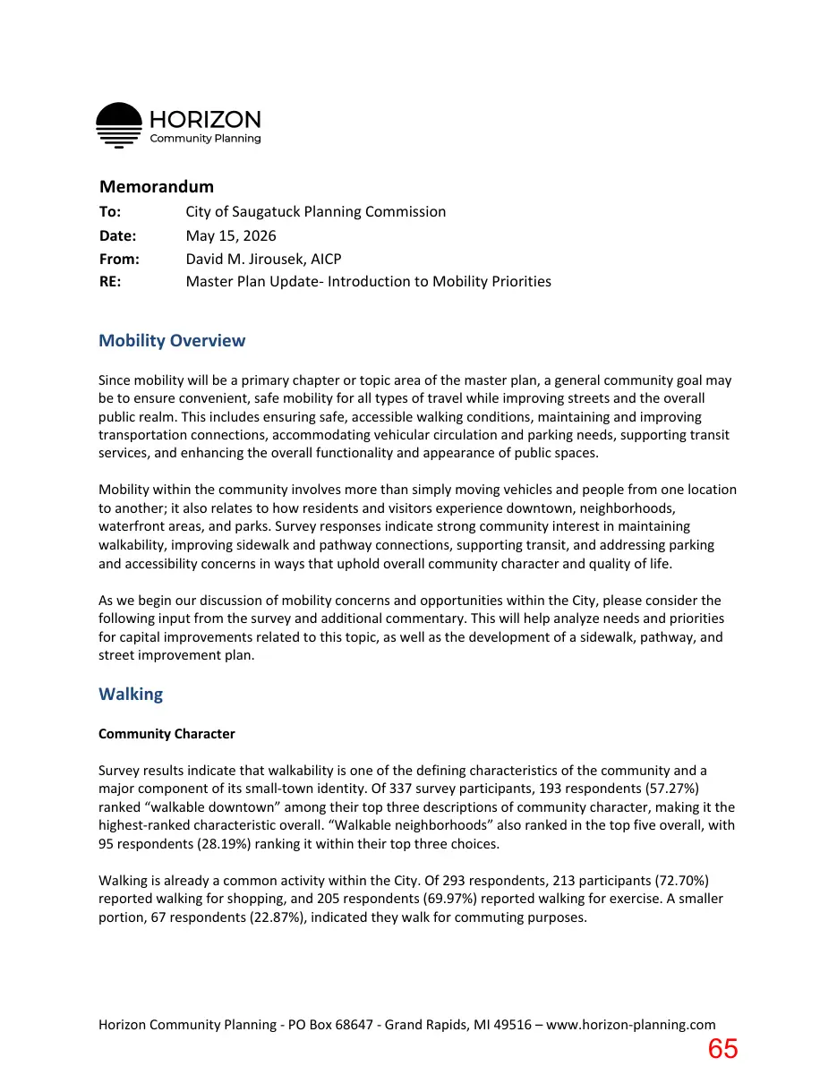
Mobility Overview Since mobility will be a primary chapter or topic area of the master plan, a general community goal may be to ensure convenient, safe mobility for all types of travel while improving streets and the overall public realm. This includes ensuring safe, accessible walking conditions, maintaining and improving transportation connections, accommodating vehicular circulation and parking needs, supporting transit services, and enhancing the overall functionality and appearance of public spaces. Mobility within the community involves more than simply moving vehicles and people from one location to another; it also relates to how residents and visitors experience downtown, neighborhoods, waterfront areas, and parks. Survey responses indicate strong community interest in maintaining walkability, improving sidewalk and pathway connections, supporting transit, and addressing parking and accessibility concerns in ways that uphold overall community character and quality of life. As we begin our discussion of mobility concerns and opportunities within the City, please consider the following input from the survey and additional commentary. This will help analyze needs and priorities for capital improvements related to this topic, as well as the development of a sidewalk, pathway, and street improvement plan.
Walking Community Character Survey results indicate that walkability is one of the defining characteristics of the community and a major component of its small-town identity. Of 337 survey participants, 193 respondents (57.27%) ranked “walkable downtown” among their top three descriptions of community character, making it the highest-ranked characteristic overall. “Walkable neighborhoods” also ranked in the top five overall, with 95 respondents (28.19%) ranking it within their top three choices. Walking is already a common activity within the City. Of 293 respondents, 213 participants (72.70%) reported walking for shopping, and 205 respondents (69.97%) reported walking for exercise. A smaller portion, 67 respondents (22.87%), indicated they walk for commuting purposes.
Horizon Community Planning - PO Box 68647 - Grand Rapids, MI 49516 – www.horizon-planning.com
Page 66
Text of page 66
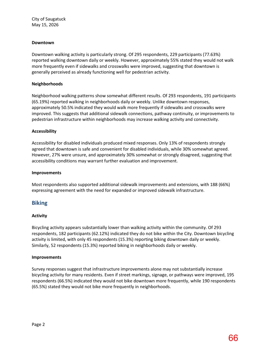
City of Saugatuck May 15, 2026 Downtown Downtown walking activity is particularly strong. Of 295 respondents, 229 participants (77.63%) reported walking downtown daily or weekly. However, approximately 55% stated they would not walk more frequently even if sidewalks and crosswalks were improved, suggesting that downtown is generally perceived as already functioning well for pedestrian activity. Neighborhoods Neighborhood walking patterns show somewhat different results. Of 293 respondents, 191 participants (65.19%) reported walking in neighborhoods daily or weekly. Unlike downtown responses, approximately 50.5% indicated they would walk more frequently if sidewalks and crosswalks were improved. This suggests that additional sidewalk connections, pathway continuity, or improvements to pedestrian infrastructure within neighborhoods may increase walking activity and connectivity. Accessibility Accessibility for disabled individuals produced mixed responses. Only 13% of respondents strongly agreed that downtown is safe and convenient for disabled individuals, while 30% somewhat agreed. However, 27% were unsure, and approximately 30% somewhat or strongly disagreed, suggesting that accessibility conditions may warrant further evaluation and improvement. Improvements Most respondents also supported additional sidewalk improvements and extensions, with 188 (66%) expressing agreement with the need for expanded or improved sidewalk infrastructure.
Biking Activity Bicycling activity appears substantially lower than walking activity within the community. Of 293 respondents, 182 participants (62.12%) indicated they do not bike within the City. Downtown bicycling activity is limited, with only 45 respondents (15.3%) reporting biking downtown daily or weekly. Similarly, 52 respondents (15.3%) reported biking in neighborhoods daily or weekly. Improvements Survey responses suggest that infrastructure improvements alone may not substantially increase bicycling activity for many residents. Even if street markings, signage, or pathways were improved, 195 respondents (66.5%) indicated they would not bike downtown more frequently, while 190 respondents (65.5%) stated they would not bike more frequently in neighborhoods.
Page 2
Page 67
Text of page 67
City of Saugatuck May 15, 2026
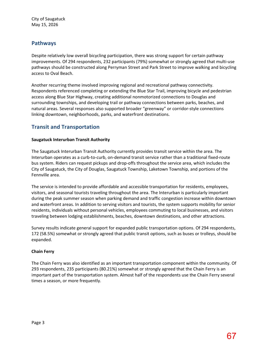
Pathways Despite relatively low overall bicycling participation, there was strong support for certain pathway improvements. Of 294 respondents, 232 participants (79%) somewhat or strongly agreed that multi-use pathways should be constructed along Perryman Street and Park Street to improve walking and bicycling access to Oval Beach. Another recurring theme involved improving regional and recreational pathway connectivity. Respondents referenced completing or extending the Blue Star Trail, improving bicycle and pedestrian access along Blue Star Highway, creating additional nonmotorized connections to Douglas and surrounding townships, and developing trail or pathway connections between parks, beaches, and natural areas. Several responses also supported broader “greenway” or corridor-style connections linking downtown, neighborhoods, parks, and waterfront destinations.
Transit and Transportation Saugatuck Interurban Transit Authority The Saugatuck Interurban Transit Authority currently provides transit service within the area. The Interurban operates as a curb-to-curb, on-demand transit service rather than a traditional fixed-route bus system. Riders can request pickups and drop-offs throughout the service area, which includes the City of Saugatuck, the City of Douglas, Saugatuck Township, Laketown Township, and portions of the Fennville area. The service is intended to provide affordable and accessible transportation for residents, employees, visitors, and seasonal tourists traveling throughout the area. The Interurban is particularly important during the peak summer season when parking demand and traffic congestion increase within downtown and waterfront areas. In addition to serving visitors and tourists, the system supports mobility for senior residents, individuals without personal vehicles, employees commuting to local businesses, and visitors traveling between lodging establishments, beaches, downtown destinations, and other attractions. Survey results indicate general support for expanded public transportation options. Of 294 respondents, 172 (58.5%) somewhat or strongly agreed that public transit options, such as buses or trolleys, should be expanded. Chain Ferry The Chain Ferry was also identified as an important transportation component within the community. Of 293 respondents, 235 participants (80.21%) somewhat or strongly agreed that the Chain Ferry is an important part of the transportation system. Almost half of the respondents use the Chain Ferry several times a season, or more frequently.
Page 3
Page 68
Text of page 68
City of Saugatuck May 15, 2026
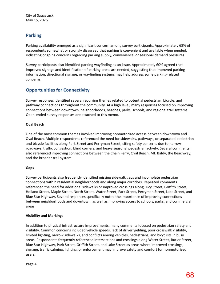
Parking Parking availability emerged as a significant concern among survey participants. Approximately 68% of respondents somewhat or strongly disagreed that parking is convenient and available when needed, indicating ongoing concerns regarding parking supply, convenience, or seasonal demand pressures. Survey participants also identified parking wayfinding as an issue. Approximately 60% agreed that improved signage and identification of parking areas are needed, suggesting that improved parking information, directional signage, or wayfinding systems may help address some parking-related concerns.
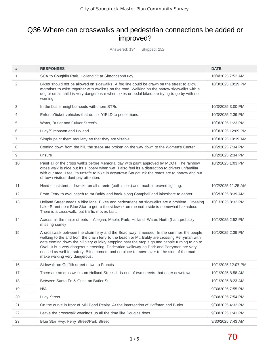
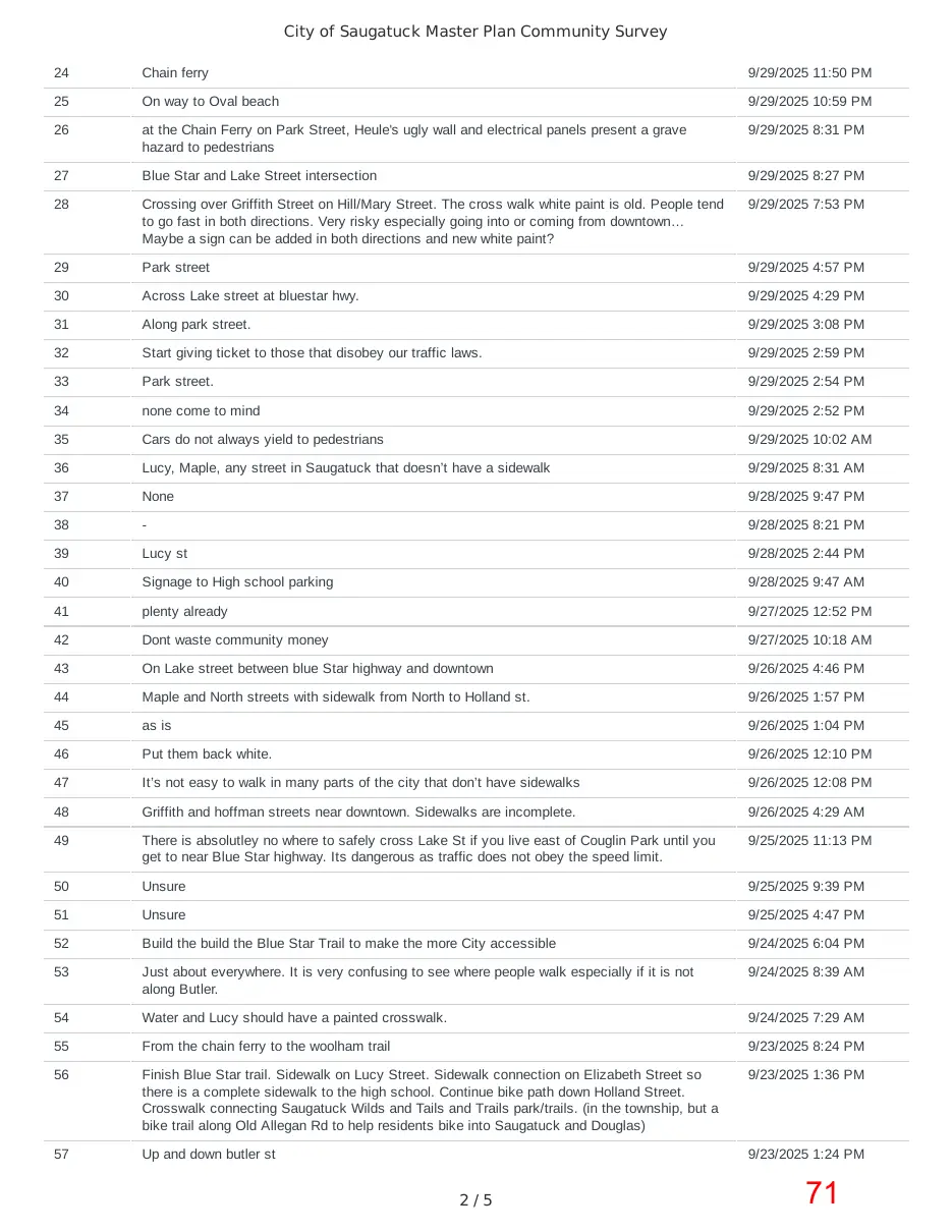
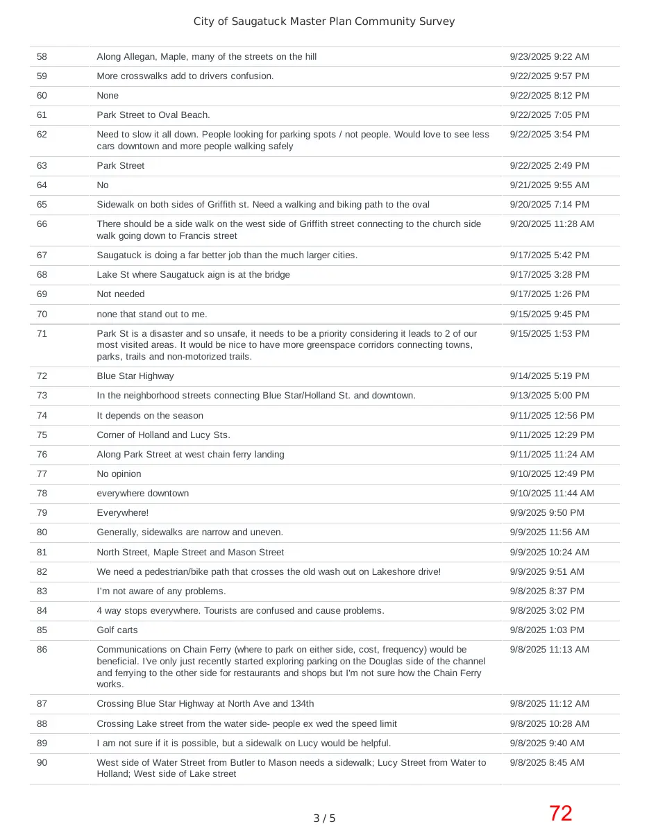
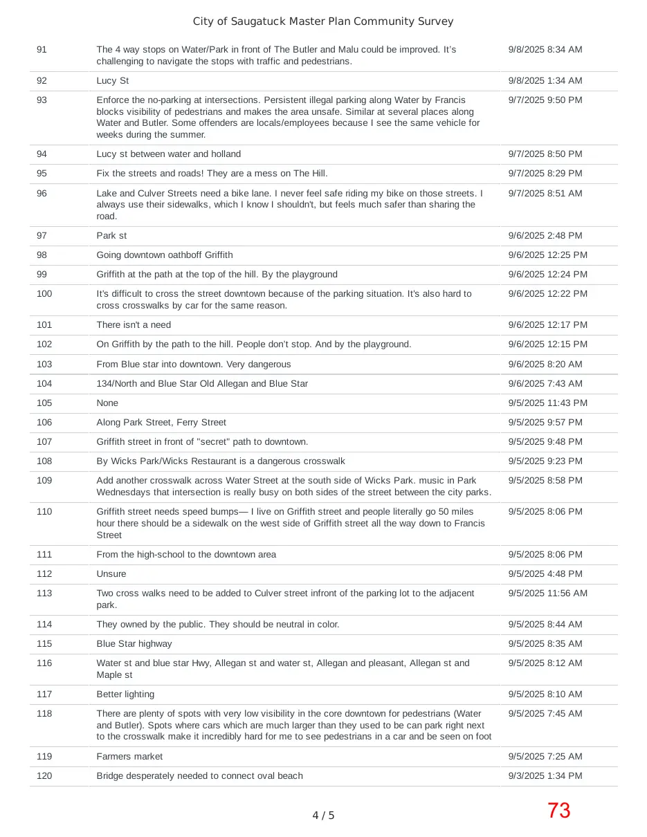
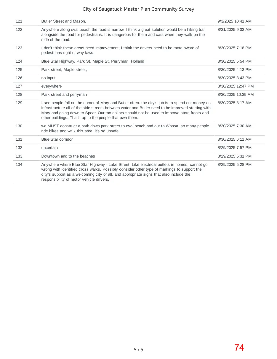
Opportunities for Connectivity Survey responses identified several recurring themes related to potential pedestrian, bicycle, and pathway connections throughout the community. At a high level, many responses focused on improving connections between downtown, neighborhoods, beaches, parks, schools, and regional trail systems. Open-ended survey responses are attached to this memo. Oval Beach One of the most common themes involved improving nonmotorized access between downtown and Oval Beach. Multiple respondents referenced the need for sidewalks, pathways, or separated pedestrian and bicycle facilities along Park Street and Perryman Street, citing safety concerns due to narrow roadways, traffic congestion, blind corners, and heavy seasonal pedestrian activity. Several comments also referenced improving connections between the Chain Ferry, Oval Beach, Mt. Baldy, the Beachway, and the broader trail system. Gaps Survey participants also frequently identified missing sidewalk gaps and incomplete pedestrian connections within residential neighborhoods and along major corridors. Repeated comments referenced the need for additional sidewalks or improved crossings along Lucy Street, Griffith Street, Holland Street, Maple Street, North Street, Water Street, Park Street, Perryman Street, Lake Street, and Blue Star Highway. Several responses specifically noted the importance of improving connections between neighborhoods and downtown, as well as improving access to schools, parks, and commercial areas. Visibility and Markings In addition to physical infrastructure improvements, many comments focused on pedestrian safety and visibility. Common concerns included vehicle speeds, lack of driver yielding, poor crosswalk visibility, limited lighting, narrow sidewalks, and conflicts among vehicles, pedestrians, and bicyclists in busy areas. Respondents frequently referenced intersections and crossings along Water Street, Butler Street, Blue Star Highway, Park Street, Griffith Street, and Lake Street as areas where improved crossings, signage, traffic calming, lighting, or enforcement may improve safety and comfort for nonmotorized users. Page 4
Page 69
Text of page 69
City of Saugatuck May 15, 2026
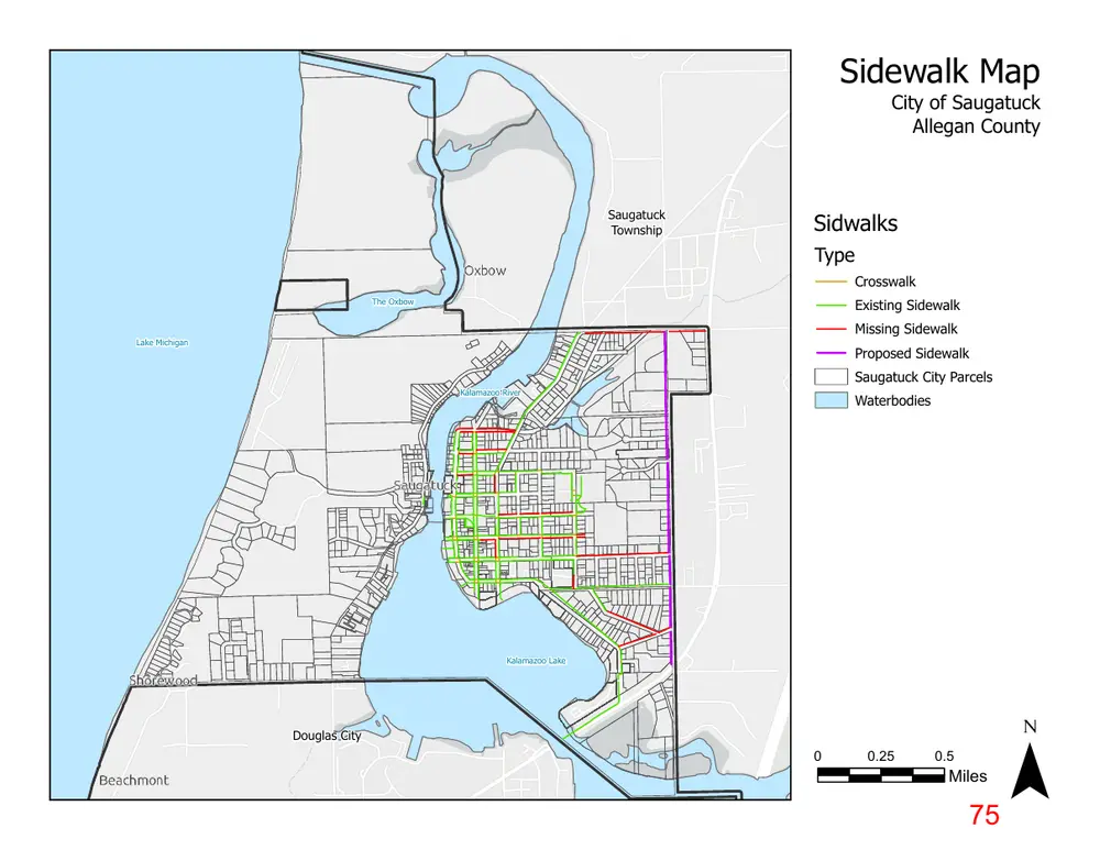
Map Analysis Exercise As part of the master planning process, the City has also prepared a map of the sidewalk system that can be reviewed and analyzed alongside the survey responses and public input. Reviewing the map together with these comments may help identify missing gaps, incomplete connections, priority corridors, safety concerns, and opportunities to better “complete” the overall sidewalk and pathway network. This process may also help identify how existing and future connections can better link downtown, neighborhoods, schools, parks, waterfront areas, beaches, regional trail systems, and adjacent communities into a more coordinated and connected nonmotorized transportation network.
Page 5
Page 70
Text of page 70
City of Saugatuck Master Plan Community Survey
Q36 Where can crosswalks and pedestrian connections be added or improved? Answered: 134
Skipped: 252
RESPONSES
DATE
SCA to Coughlin Park, Holland St at Simondson/Lucy
10/4/2025 7:52 AM
Bikes should not be allowed on sidewalks. A fog line could be drawn on the street to allow motorists to exist together with cyclists on the road. Walking on the narrow sidewalks with a dog or small child is very dangerous e when bikes or pedal bikes are trying to go by with no warning.
10/3/2025 10:19 PM
In the busier neighborhoods with more STRs
10/3/2025 3:00 PM
Enforce/ticket vehicles that do not YIELD to pedestrians.
10/3/2025 2:39 PM
Water, Butler and Culver Street's
10/3/2025 1:23 PM
Lucy/Simonson and Holland
10/3/2025 12:09 PM
Simply paint them regularly so that they are visable.
10/3/2025 10:19 AM
Coming down from the hill, the steps are broken on the way down to the Women’s Center.
10/2/2025 7:34 PM
unsure
10/2/2025 2:34 PM
Paint all of the cross walks before Memorial day with paint approved by MDOT. The rainbow cross walk is nice but its slippery when wet. I also feel its a distraction to drivers unfamiliar with our area. I feel its unsafe to bike in downtown Saugatuck the roads are to narrow and out of town visitors dont pay attention.
10/2/2025 1:03 PM
Need consistent sidewalks on all streets (both sides) and much improved lighting.
10/2/2025 11:25 AM
From Ferry to oval beach to mt Baldy and back along Campbell and lakeshore to center
10/2/2025 8:39 AM
Holland Street needs a bike lane. Bikes and pedestrians on sidewalks are a problem. Crossing Lake Street near Blue Star to get to the sidewalk on the north side is somewhat hazardous. There is a crosswalk, but traffic moves fast.
10/1/2025 8:32 PM
Across all the major streets -- Allegan, Maple, Park, Holland, Water, North (I am probably missing some)
10/1/2025 2:52 PM
A crosswalk between the chain ferry and the Beachway is needed. In the summer, the people walking to the and from the chain ferry to the beach or Mt. Baldy are crossing Perryman with cars coming down the hill very quickly stopping past the stop sign and people turning to go to Oval. It is a very dangerous crossing. Pedestrian walkway on Park and Perryman are very needed as well for safety. Blind corners and no place to move over to the side of the road make walking very dangerous.
10/1/2025 2:39 PM
Sidewalk on Griffith street down to Francis
10/1/2025 12:07 PM
There are no crosswalks on Holland Street. It is one of two streets that enter downtown.
10/1/2025 8:58 AM
Between Santa Fe & Grins on Butler St
10/1/2025 8:23 AM
N/A
9/30/2025 7:55 PM
Lucy Street
9/30/2025 7:54 PM
On the curve in front of Mill Pond Realty. At the intersection of Hoffman and Butler.
9/30/2025 4:32 PM
Leave the crosswalk warnings up all the time like Douglas does
9/30/2025 1:41 PM
Blue Star Hwy, Ferry Street/Park Street
9/30/2025 7:43 AM
1/5
Page 71
Text of page 71
City of Saugatuck Master Plan Community Survey 24
Chain ferry
9/29/2025 11:50 PM
On way to Oval beach
9/29/2025 10:59 PM
at the Chain Ferry on Park Street, Heule's ugly wall and electrical panels present a grave hazard to pedestrians
9/29/2025 8:31 PM
Blue Star and Lake Street intersection
9/29/2025 8:27 PM
Crossing over Griffith Street on Hill/Mary Street. The cross walk white paint is old. People tend to go fast in both directions. Very risky especially going into or coming from downtown… Maybe a sign can be added in both directions and new white paint?
9/29/2025 7:53 PM
Park street
9/29/2025 4:57 PM
Across Lake street at bluestar hwy.
9/29/2025 4:29 PM
Along park street.
9/29/2025 3:08 PM
Start giving ticket to those that disobey our traffic laws.
9/29/2025 2:59 PM
Park street.
9/29/2025 2:54 PM
none come to mind
9/29/2025 2:52 PM
Cars do not always yield to pedestrians
9/29/2025 10:02 AM
Lucy, Maple, any street in Saugatuck that doesn’t have a sidewalk
9/29/2025 8:31 AM
None
9/28/2025 9:47 PM
9/28/2025 8:21 PM
Lucy st
9/28/2025 2:44 PM
Signage to High school parking
9/28/2025 9:47 AM
plenty already
9/27/2025 12:52 PM
Dont waste community money
9/27/2025 10:18 AM
On Lake street between blue Star highway and downtown
9/26/2025 4:46 PM
Maple and North streets with sidewalk from North to Holland st.
9/26/2025 1:57 PM
as is
9/26/2025 1:04 PM
Put them back white.
9/26/2025 12:10 PM
It’s not easy to walk in many parts of the city that don’t have sidewalks
9/26/2025 12:08 PM
Griffith and hoffman streets near downtown. Sidewalks are incomplete.
9/26/2025 4:29 AM
There is absolutley no where to safely cross Lake St if you live east of Couglin Park until you get to near Blue Star highway. Its dangerous as traffic does not obey the speed limit.
9/25/2025 11:13 PM
Unsure
9/25/2025 9:39 PM
Unsure
9/25/2025 4:47 PM
Build the build the Blue Star Trail to make the more City accessible
9/24/2025 6:04 PM
Just about everywhere. It is very confusing to see where people walk especially if it is not along Butler.
9/24/2025 8:39 AM
Water and Lucy should have a painted crosswalk.
9/24/2025 7:29 AM
From the chain ferry to the woolham trail
9/23/2025 8:24 PM
Finish Blue Star trail. Sidewalk on Lucy Street. Sidewalk connection on Elizabeth Street so there is a complete sidewalk to the high school. Continue bike path down Holland Street. Crosswalk connecting Saugatuck Wilds and Tails and Trails park/trails. (in the township, but a bike trail along Old Allegan Rd to help residents bike into Saugatuck and Douglas)
9/23/2025 1:36 PM
Up and down butler st
9/23/2025 1:24 PM
2/5
Page 72
Text of page 72
City of Saugatuck Master Plan Community Survey 58
Along Allegan, Maple, many of the streets on the hill
9/23/2025 9:22 AM
More crosswalks add to drivers confusion.
9/22/2025 9:57 PM
None
9/22/2025 8:12 PM
Park Street to Oval Beach.
9/22/2025 7:05 PM
Need to slow it all down. People looking for parking spots / not people. Would love to see less cars downtown and more people walking safely
9/22/2025 3:54 PM
Park Street
9/22/2025 2:49 PM
No
9/21/2025 9:55 AM
Sidewalk on both sides of Griffith st. Need a walking and biking path to the oval
9/20/2025 7:14 PM
There should be a side walk on the west side of Griffith street connecting to the church side walk going down to Francis street
9/20/2025 11:28 AM
Saugatuck is doing a far better job than the much larger cities.
9/17/2025 5:42 PM
Lake St where Saugatuck aign is at the bridge
9/17/2025 3:28 PM
Not needed
9/17/2025 1:26 PM
none that stand out to me.
9/15/2025 9:45 PM
Park St is a disaster and so unsafe, it needs to be a priority considering it leads to 2 of our most visited areas. It would be nice to have more greenspace corridors connecting towns, parks, trails and non-motorized trails.
9/15/2025 1:53 PM
Blue Star Highway
9/14/2025 5:19 PM
In the neighborhood streets connecting Blue Star/Holland St. and downtown.
9/13/2025 5:00 PM
It depends on the season
9/11/2025 12:56 PM
Corner of Holland and Lucy Sts.
9/11/2025 12:29 PM
Along Park Street at west chain ferry landing
9/11/2025 11:24 AM
No opinion
9/10/2025 12:49 PM
everywhere downtown
9/10/2025 11:44 AM
Everywhere!
9/9/2025 9:50 PM
Generally, sidewalks are narrow and uneven.
9/9/2025 11:56 AM
North Street, Maple Street and Mason Street
9/9/2025 10:24 AM
We need a pedestrian/bike path that crosses the old wash out on Lakeshore drive!
9/9/2025 9:51 AM
I’m not aware of any problems.
9/8/2025 8:37 PM
4 way stops everywhere. Tourists are confused and cause problems.
9/8/2025 3:02 PM
Golf carts
9/8/2025 1:03 PM
Communications on Chain Ferry (where to park on either side, cost, frequency) would be beneficial. I've only just recently started exploring parking on the Douglas side of the channel and ferrying to the other side for restaurants and shops but I'm not sure how the Chain Ferry works.
9/8/2025 11:13 AM
Crossing Blue Star Highway at North Ave and 134th
9/8/2025 11:12 AM
Crossing Lake street from the water sidepeople ex wed the speed limit
9/8/2025 10:28 AM
I am not sure if it is possible, but a sidewalk on Lucy would be helpful.
9/8/2025 9:40 AM
West side of Water Street from Butler to Mason needs a sidewalk; Lucy Street from Water to Holland; West side of Lake street
9/8/2025 8:45 AM
3/5
Page 73
Text of page 73
City of Saugatuck Master Plan Community Survey 91
The 4 way stops on Water/Park in front of The Butler and Malu could be improved. It’s challenging to navigate the stops with traffic and pedestrians.
9/8/2025 8:34 AM
Lucy St
9/8/2025 1:34 AM
Enforce the no-parking at intersections. Persistent illegal parking along Water by Francis blocks visibility of pedestrians and makes the area unsafe. Similar at several places along Water and Butler. Some offenders are locals/employees because I see the same vehicle for weeks during the summer.
9/7/2025 9:50 PM
Lucy st between water and holland
9/7/2025 8:50 PM
Fix the streets and roads! They are a mess on The Hill.
9/7/2025 8:29 PM
Lake and Culver Streets need a bike lane. I never feel safe riding my bike on those streets. I always use their sidewalks, which I know I shouldn't, but feels much safer than sharing the road.
9/7/2025 8:51 AM
Park st
9/6/2025 2:48 PM
Going downtown oathboff Griffith
9/6/2025 12:25 PM
Griffith at the path at the top of the hill. By the playground
9/6/2025 12:24 PM
It's difficult to cross the street downtown because of the parking situation. It's also hard to cross crosswalks by car for the same reason.
9/6/2025 12:22 PM
There isn't a need
9/6/2025 12:17 PM
On Griffith by the path to the hill. People don’t stop. And by the playground.
9/6/2025 12:15 PM
From Blue star into downtown. Very dangerous
9/6/2025 8:20 AM
134/North and Blue Star Old Allegan and Blue Star
9/6/2025 7:43 AM
None
9/5/2025 11:43 PM
Along Park Street, Ferry Street
9/5/2025 9:57 PM
Griffith street in front of "secret" path to downtown.
9/5/2025 9:48 PM
By Wicks Park/Wicks Restaurant is a dangerous crosswalk
9/5/2025 9:23 PM
Add another crosswalk across Water Street at the south side of Wicks Park. music in Park Wednesdays that intersection is really busy on both sides of the street between the city parks.
9/5/2025 8:58 PM
Griffith street needs speed bumps— I live on Griffith street and people literally go 50 miles hour there should be a sidewalk on the west side of Griffith street all the way down to Francis Street
9/5/2025 8:06 PM
From the high-school to the downtown area
9/5/2025 8:06 PM
Unsure
9/5/2025 4:48 PM
Two cross walks need to be added to Culver street infront of the parking lot to the adjacent park.
9/5/2025 11:56 AM
They owned by the public. They should be neutral in color.
9/5/2025 8:44 AM
Blue Star highway
9/5/2025 8:35 AM
Water st and blue star Hwy, Allegan st and water st, Allegan and pleasant, Allegan st and Maple st
9/5/2025 8:12 AM
Better lighting
9/5/2025 8:10 AM
There are plenty of spots with very low visibility in the core downtown for pedestrians (Water and Butler). Spots where cars which are much larger than they used to be can park right next to the crosswalk make it incredibly hard for me to see pedestrians in a car and be seen on foot
9/5/2025 7:45 AM
Farmers market
9/5/2025 7:25 AM
Bridge desperately needed to connect oval beach
9/3/2025 1:34 PM
4/5
Page 74
Text of page 74
City of Saugatuck Master Plan Community Survey 121
Butler Street and Mason.
9/3/2025 10:41 AM
Anywhere along oval beach the road is narrow. I think a great solution would be a hiking trail alongside the road for pedestrians. It is dangerous for them and cars when they walk on the side of the road.
8/31/2025 9:33 AM
I don't think these areas need improvement; I think the drivers need to be more aware of pedestrians right of way laws
8/30/2025 7:18 PM
Blue Star Highway, Park St, Maple St, Perryman, Holland
8/30/2025 5:54 PM
Park street, Maple street,
8/30/2025 4:13 PM
no input
8/30/2025 3:43 PM
everywhere
8/30/2025 12:47 PM
Park street and perryman
8/30/2025 10:39 AM
I see people fall on the corner of Mary and Butler often. the city's job is to spend our money on infrastructure all of the side streets between water and Butler need to be improved starting with Mary and going down to Spear. Our tax dollars should not be used to improve store fronts and other buildings. That's up to the people that own them.
8/30/2025 8:17 AM
we MUST construct a path down park street to oval beach and out to Woosa. so many people ride bikes and walk this area, it's so unsafe
8/30/2025 7:30 AM
Blue Star corridor
8/30/2025 6:11 AM
uncertain
8/29/2025 7:57 PM
Downtown and to the beaches
8/29/2025 5:31 PM
Anywhere where Blue Star Highway - Lake Street. Like electrical outlets in homes, cannot go wrong with identified cross walks. Possibly consider other type of markings to support the city’s support as a welcoming city of all, and appropriate signs that also include the responsibility of motor vehicle drivers.
8/29/2025 5:28 PM
5/5
Page 75
Text of page 75
Sidewalk Map City of Saugatuck Allegan County
Saugatuck Township
Sidwalks Type Crosswalk
The Oxbow
Existing Sidewalk Missing Sidewalk
Lake Michigan
Proposed Sidewalk Saugatuck City Parcels Kalamazoo River
Waterbodies
Kalamazoo Lake
Douglas City
0.25
0.5
Miles
Page 76
Text of page 76
Memorandum To: Date: From: RE:
City of Saugatuck Planning Commission April 10, 2026 David M. Jirousek, AICP Master Plan UpdateCharacter Analysis Progress Report and Exercise
Overview As part of the ongoing Master Plan process, the project team has initiated a community character analysis to supplement findings from public input and the existing land use review. This analysis is intended to better understand the unique qualities of the City and its neighborhoods in ways that a traditional existing land use map alone cannot capture. Rather than serving as a simple inventory of land uses, the analysis evaluates the physical and functional characteristics that define districts, neighborhoods, and corridors, including development scale, block and lot patterns, street and sidewalk networks, pathways, parking, building types, and land use relationships. This approach is helping the Planning Commission more clearly identify areas to preserve, enhance, or thoughtfully transform, and will provide a stronger foundation for future land use recommendations and zoning policy decisions. Ultimately, the character analysis is intended to ensure that future growth and development align with Saugatuck’s established character and community context. To better understand the City’s physical form and development patterns, the community has been divided into character areas. These areas represent distinct parts of the City that share common patterns in land use, development intensity, built form, and environmental context. This analysis serves several purposes: §
Classifies areas based on common characteristics, including land use, zoning, density, intensity, infrastructure, and utilities, and helps to define a sense of place.
Establishes a clear and simplified framework for future growth and land use planning.
Provides justification for future land use recommendations and distinctions between different parts of the City.
Each character area is evaluated using the following components: §
Buildings: Predominant building types, setbacks, architectural character, and general form.
Land Use: Primary and supporting uses within the area.
Scale: Building height, massing, and overall development intensity.
Blocks and Streets: Block patterns, street layout (grid, curvilinear, etc.), and connectivity.
Horizon Community Planning - PO Box 68647 - Grand Rapids, MI 49516 – www.horizon-planning.com
Page 77
Text of page 77
City of Saugatuck April 10, 2026 §
Streetscape: Sidewalks, street trees, lighting, and pedestrian environment.
Public Space: Parks, plazas, waterfront access, and civic spaces.
Parking: On-street and off-street parking patterns and visibility.
Walkability: Distance from downtown and ease of pedestrian travel.
Intent The Planning Commission is encouraged to review this character area framework and provide input to further refine and define what distinguishes each area. In particular, consideration should be given to whether these areas accurately represent the unique parts of the City or if additional distinctions, subareas, or refinements are warranted. Commissioners are also encouraged to suggest alternative names or descriptors that better capture the character, identity, and function of each area. While this framework establishes an initial structure, it should be viewed as a working draft document intended to solicit feedback and discussion. This exercise should be approached independently of existing zoning designations, with a fresh perspective focused on the physical, functional, and experiential qualities that define neighborhoods and districts. The intent is to identify what makes areas similar or different based on real-world characteristics rather than regulatory boundaries. This type of analysis also provides an opportunity to consider the unique opportunities, needs, concerns, and priorities associated with each planning area. By evaluating areas based on their existing character and conditions, the City can better identify where preservation is appropriate, where enhancements may be needed, and where change or reinvestment may be supported. This helps inform more thoughtful and context-sensitive planning decisions moving forward. It is also important to note that delineating character area boundaries does not directly establish future land use or zoning. This analysis reflects existing conditions and serves as a foundation for understanding the City today. Future land use planning will build upon this work by identifying how areas should be preserved, enhanced, or transformed over time.
Page 2
Page 78
Text of page 78
City of Saugatuck April 10, 2026
Planning Areas The City has been organized into three primary planning areas, each containing multiple distinct character areas. This structure is intended to provide a clear, manageable framework for understanding and evaluating the City from a planning perspective. By grouping character areas within broader planning areas, the analysis can focus on both larger geographic patterns and the finer-grained distinctions between neighborhoods, districts, and corridors. §
Central City o
Central Downtown Activity Center
Downtown Waterfront Commercial
Downtown Neighborhood Mixed-Use
Transitional Residential
Central City Residential
East Side Neighborhoods o
Traditional Neighborhood Residential
North Riverfront Residential
South Riverfront Mixed Residential
North Marina/Harbor Services Area
South Hillside Residential
Suburban/Rural Fringe Residential
Coastal Dunes and Peninsula o
West Riverfront Residential
Coastal Dune Residential
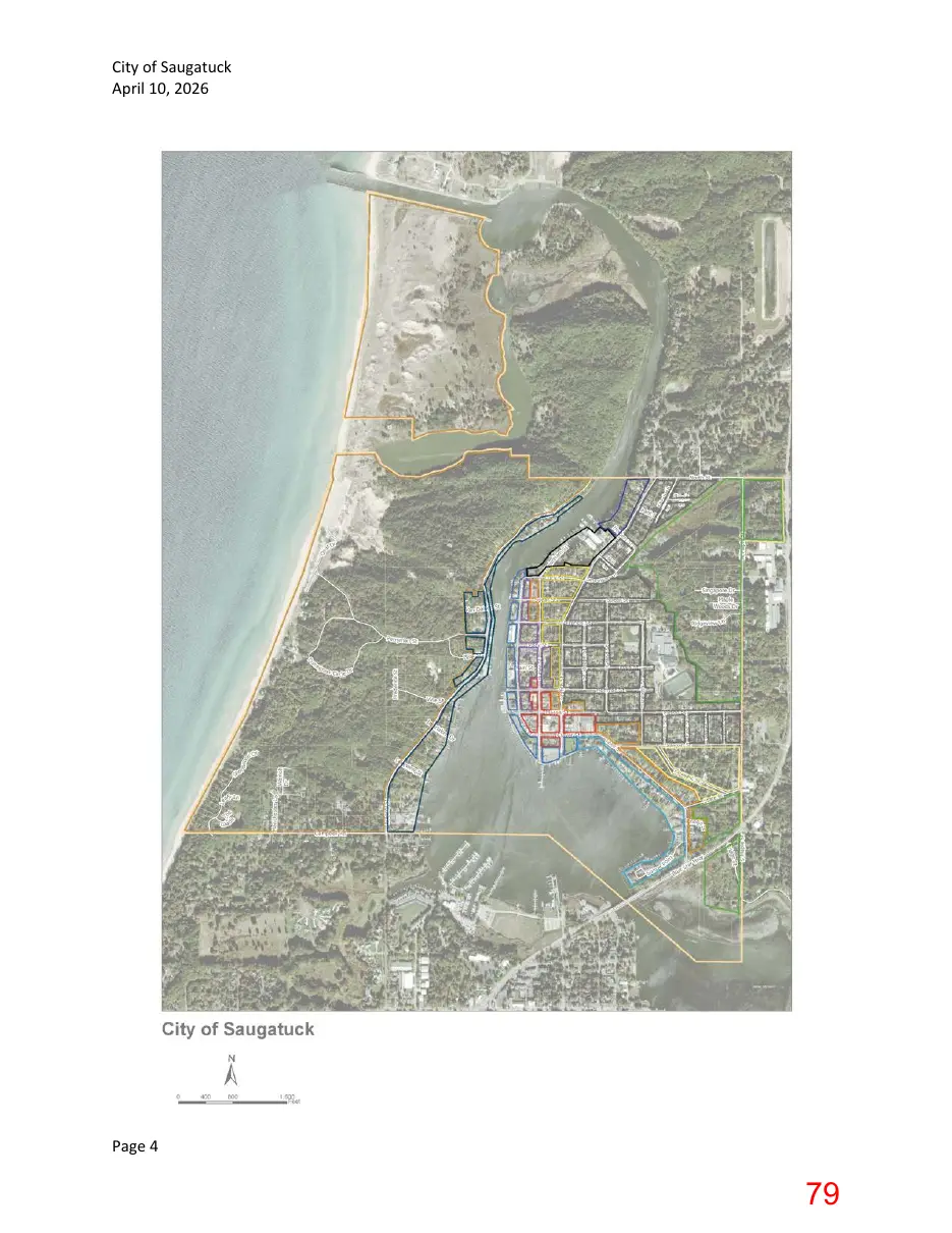
The planning areas reflect natural divisions within the community, shaped by geography, waterfront features, transportation patterns, and the overall arrangement of development. This approach allows for a more organized and practical assessment of existing conditions, ensuring that major portions of the City can be evaluated cohesively while still recognizing the unique characteristics that define smaller areas within each planning area. Please note that these areas have not been formally mapped, but preliminary exhibits are included over the following pages.
Page 3
Page 79
Text of page 79
City of Saugatuck April 10, 2026
Page 4
Page 80
Text of page 80
City of Saugatuck April 10, 2026
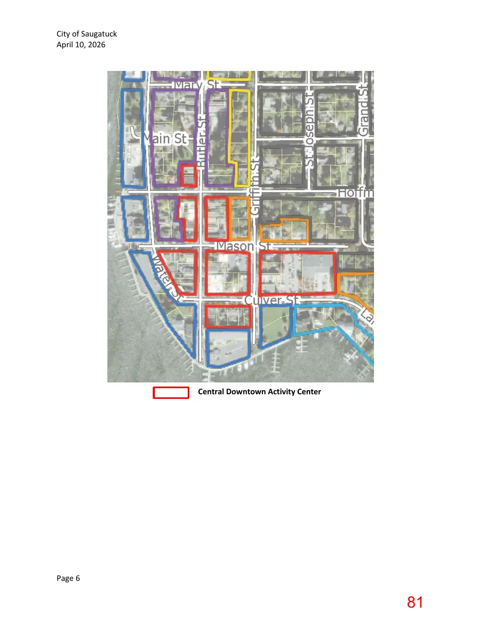
Planning Area One: Central City This area represents the heart of Saugatuck and contains the highest concentration of commercial activity, tourism destinations, civic uses, and walkable neighborhoods. It is defined by a compact development pattern, strong pedestrian orientation, and direct access to the waterfront. Central Downtown Activity Center The Central Downtown Activity Center represents the historic and functional core of the City and serves as its primary center of activity. It is characterized by a cohesive pattern of traditional downtown buildings that define a continuous street edge and support an active, pedestrian-oriented environment. A mix of commercial, civic, and entertainment uses contributes to a vibrant atmosphere. This area serves as the focal point for daily activities, tourism, and community gatherings. Butler and Culver Streets serve as the focal points of the character area. The area is characterized by a cohesive pattern of oneto two-story traditional downtown buildings, many of which are contributing resources within the Historic District, forming a largely continuous “street wall” of buildings from Culver Street to Hoffman Street. In this area, buildings are commonly attached or detached with minimal separations, reinforcing a highly active, pedestrian-oriented environment. However, while the area is predominantly defined by attached storefronts or buildings drawn closer to the right-of-way, the presence of house-scale detached buildings contributes to an eclectic, varied character. This Central Downtown Activity Center is supported by wide sidewalks that extend from building facades to the curb, mature street trees, and streetscape elements such as bike racks, garbage receptacles, and clearly marked crosswalks. §
Buildings: Traditional historic storefronts drawn close to the street; attached buildings or those with minimal setbacks, with some house-scale detached buildings interspersed
Land Use: Retail, offices, restaurants, taverns, entertainment, services, and civic uses
Scale: 1–2 story buildings, occasionally 2.5; compact and continuous at a higher intensity
Blocks and Streets: Traditional street grid with strong connectivity
Streetscape: Wide sidewalks, wayfinding signage, outdoor dining areas, street trees, bike racks, planter boxes, public art, benches, hatched crosswalks, standard street lighting (some decorative), and overhead powerlines
Public Space: Civic spaces, City Hall
Parking: On-street parking on both sides of the streets and two public parking lots with 122 spaces
Walkability: 0-5 minute walk throughout the Central Downtown Activity Center with a mostly complete network of sidewalks
Page 5
Page 81
Text of page 81
City of Saugatuck April 10, 2026
Central Downtown Activity Center
Page 6
Page 82
Text of page 82
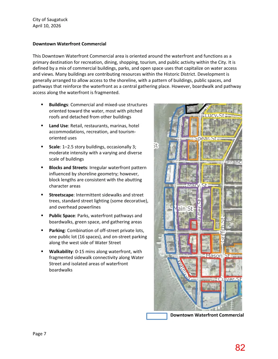
City of Saugatuck April 10, 2026 Downtown Waterfront Commercial This Downtown Waterfront Commercial area is oriented around the waterfront and functions as a primary destination for recreation, dining, shopping, tourism, and public activity within the City. It is defined by a mix of commercial buildings, parks, and open space uses that capitalize on water access and views. Many buildings are contributing resources within the Historic District. Development is generally arranged to allow access to the shoreline, with a pattern of buildings, public spaces, and pathways that reinforce the waterfront as a central gathering place. However, boardwalk and pathway access along the waterfront is fragmented. §
Buildings: Commercial and mixed-use structures oriented toward the water, most with pitched roofs and detached from other buildings
Land Use: Retail, restaurants, marinas, hotel accommodations, recreation, and tourismoriented uses
Scale: 1–2.5 story buildings, occasionally 3; moderate intensity with a varying and diverse scale of buildings
Blocks and Streets: Irregular waterfront pattern influenced by shoreline geometry; however, block lengths are consistent with the abutting character areas
Streetscape: Intermittent sidewalks and street trees, standard street lighting (some decorative), and overhead powerlines
Public Space: Parks, waterfront pathways and boardwalks, green space, and gathering areas
Parking: Combination of off-street private lots, one public lot (16 spaces), and on-street parking along the west side of Water Street
Walkability: 0-15 mins along waterfront, with fragmented sidewalk connectivity along Water Street and isolated areas of waterfront boardwalks
Downtown Waterfront Commercial Page 7
Page 83
Text of page 83
City of Saugatuck April 10, 2026
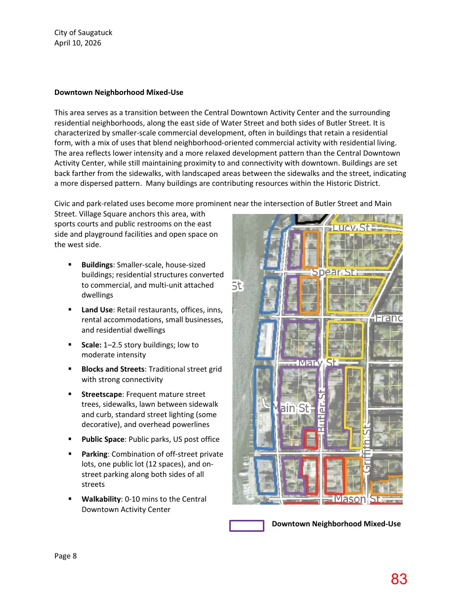
Downtown Neighborhood Mixed-Use This area serves as a transition between the Central Downtown Activity Center and the surrounding residential neighborhoods, along the east side of Water Street and both sides of Butler Street. It is characterized by smaller-scale commercial development, often in buildings that retain a residential form, with a mix of uses that blend neighborhood-oriented commercial activity with residential living. The area reflects lower intensity and a more relaxed development pattern than the Central Downtown Activity Center, while still maintaining proximity to and connectivity with downtown. Buildings are set back farther from the sidewalks, with landscaped areas between the sidewalks and the street, indicating a more dispersed pattern. Many buildings are contributing resources within the Historic District. Civic and park-related uses become more prominent near the intersection of Butler Street and Main Street. Village Square anchors this area, with sports courts and public restrooms on the east side and playground facilities and open space on the west side. §
Buildings: Smaller-scale, house-sized buildings; residential structures converted to commercial, and multi-unit attached dwellings
Land Use: Retail restaurants, offices, inns, rental accommodations, small businesses, and residential dwellings
Scale: 1–2.5 story buildings; low to moderate intensity
Blocks and Streets: Traditional street grid with strong connectivity
Streetscape: Frequent mature street trees, sidewalks, lawn between sidewalk and curb, standard street lighting (some decorative), and overhead powerlines
Public Space: Public parks, US post office
Parking: Combination of off-street private lots, one public lot (12 spaces), and onstreet parking along both sides of all streets
Walkability: 0-10 mins to the Central Downtown Activity Center Downtown Neighborhood Mixed-Use
Page 8
Page 84
Text of page 84
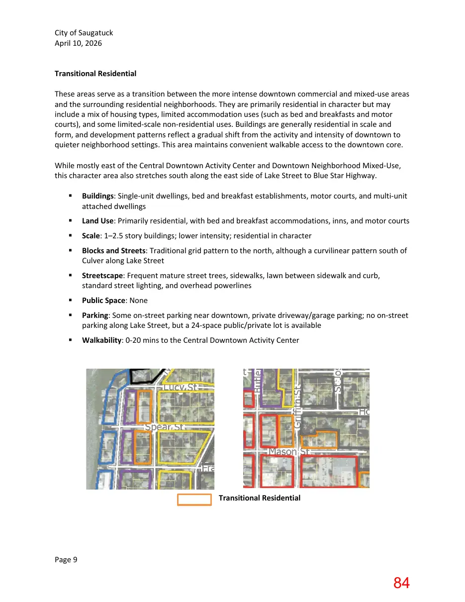
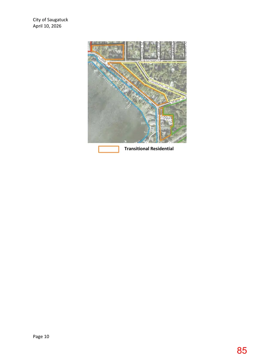
City of Saugatuck April 10, 2026 Transitional Residential These areas serve as a transition between the more intense downtown commercial and mixed-use areas and the surrounding residential neighborhoods. They are primarily residential in character but may include a mix of housing types, limited accommodation uses (such as bed and breakfasts and motor courts), and some limited-scale non-residential uses. Buildings are generally residential in scale and form, and development patterns reflect a gradual shift from the activity and intensity of downtown to quieter neighborhood settings. This area maintains convenient walkable access to the downtown core. While mostly east of the Central Downtown Activity Center and Downtown Neighborhood Mixed-Use, this character area also stretches south along the east side of Lake Street to Blue Star Highway. §
Buildings: Single-unit dwellings, bed and breakfast establishments, motor courts, and multi-unit attached dwellings
Land Use: Primarily residential, with bed and breakfast accommodations, inns, and motor courts
Scale: 1–2.5 story buildings; lower intensity; residential in character
Blocks and Streets: Traditional grid pattern to the north, although a curvilinear pattern south of Culver along Lake Street
Streetscape: Frequent mature street trees, sidewalks, lawn between sidewalk and curb, standard street lighting, and overhead powerlines
Public Space: None
Parking: Some on-street parking near downtown, private driveway/garage parking; no on-street parking along Lake Street, but a 24-space public/private lot is available
Walkability: 0-20 mins to the Central Downtown Activity Center
Transitional Residential
Page 9
Page 85
Text of page 85
City of Saugatuck April 10, 2026
Transitional Residential
Page 10
Page 86
Text of page 86
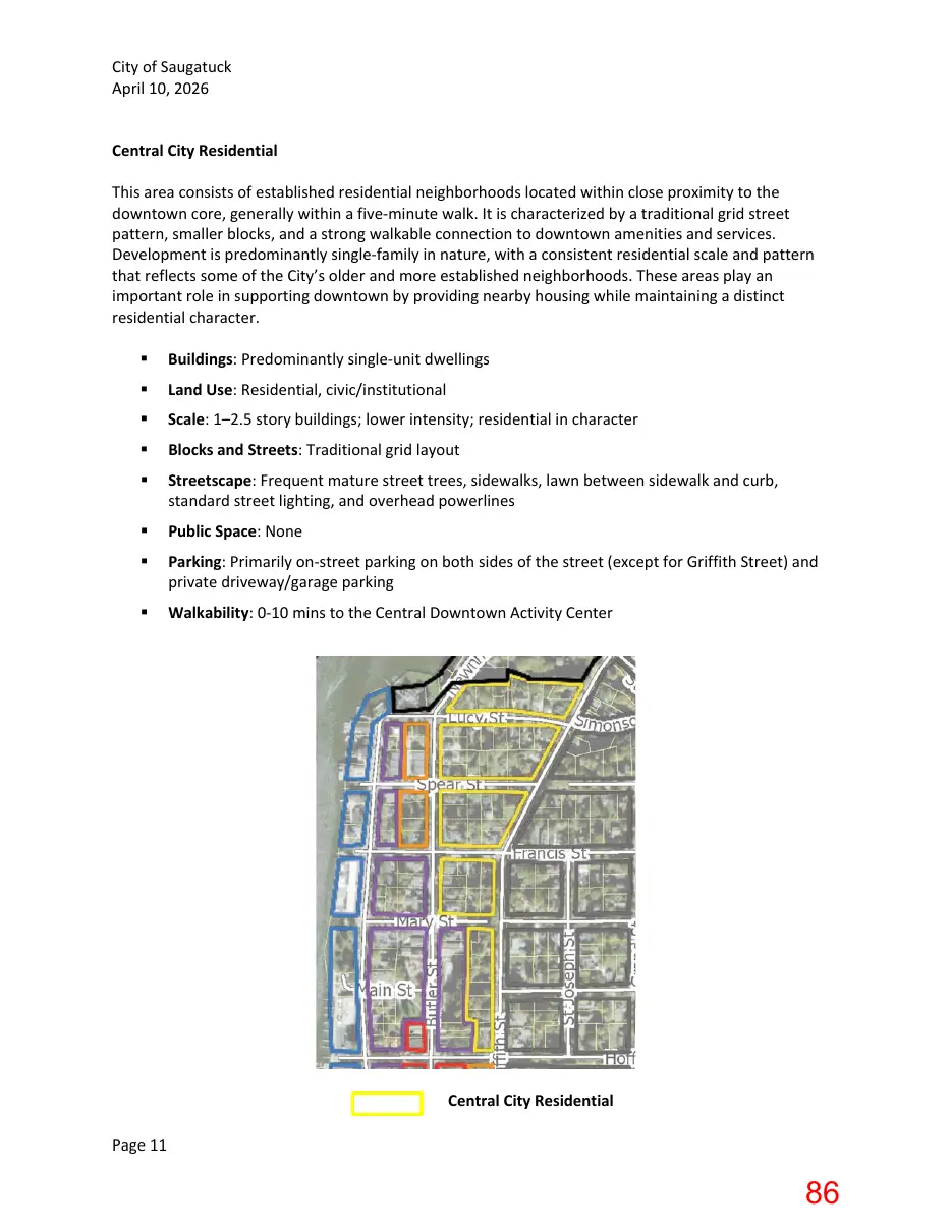
City of Saugatuck April 10, 2026 Central City Residential This area consists of established residential neighborhoods located within close proximity to the downtown core, generally within a five-minute walk. It is characterized by a traditional grid street pattern, smaller blocks, and a strong walkable connection to downtown amenities and services. Development is predominantly single-family in nature, with a consistent residential scale and pattern that reflects some of the City’s older and more established neighborhoods. These areas play an important role in supporting downtown by providing nearby housing while maintaining a distinct residential character. §
Buildings: Predominantly single-unit dwellings
Land Use: Residential, civic/institutional
Scale: 1–2.5 story buildings; lower intensity; residential in character
Blocks and Streets: Traditional grid layout
Streetscape: Frequent mature street trees, sidewalks, lawn between sidewalk and curb, standard street lighting, and overhead powerlines
Public Space: None
Parking: Primarily on-street parking on both sides of the street (except for Griffith Street) and private driveway/garage parking
Walkability: 0-10 mins to the Central Downtown Activity Center
Central City Residential Page 11
Page 87
Text of page 87
City of Saugatuck April 10, 2026
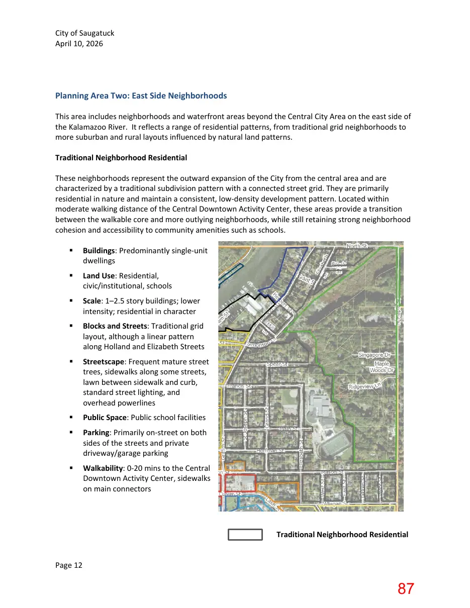
Planning Area Two: East Side Neighborhoods This area includes neighborhoods and waterfront areas beyond the Central City Area on the east side of the Kalamazoo River. It reflects a range of residential patterns, from traditional grid neighborhoods to more suburban and rural layouts influenced by natural land patterns. Traditional Neighborhood Residential These neighborhoods represent the outward expansion of the City from the central area and are characterized by a traditional subdivision pattern with a connected street grid. They are primarily residential in nature and maintain a consistent, low-density development pattern. Located within moderate walking distance of the Central Downtown Activity Center, these areas provide a transition between the walkable core and more outlying neighborhoods, while still retaining strong neighborhood cohesion and accessibility to community amenities such as schools. §
Buildings: Predominantly single-unit dwellings
Land Use: Residential, civic/institutional, schools
Scale: 1–2.5 story buildings; lower intensity; residential in character
Blocks and Streets: Traditional grid layout, although a linear pattern along Holland and Elizabeth Streets
Streetscape: Frequent mature street trees, sidewalks along some streets, lawn between sidewalk and curb, standard street lighting, and overhead powerlines
Public Space: Public school facilities
Parking: Primarily on-street on both sides of the streets and private driveway/garage parking
Walkability: 0-20 mins to the Central Downtown Activity Center, sidewalks on main connectors
Traditional Neighborhood Residential Page 12
Page 88
Text of page 88
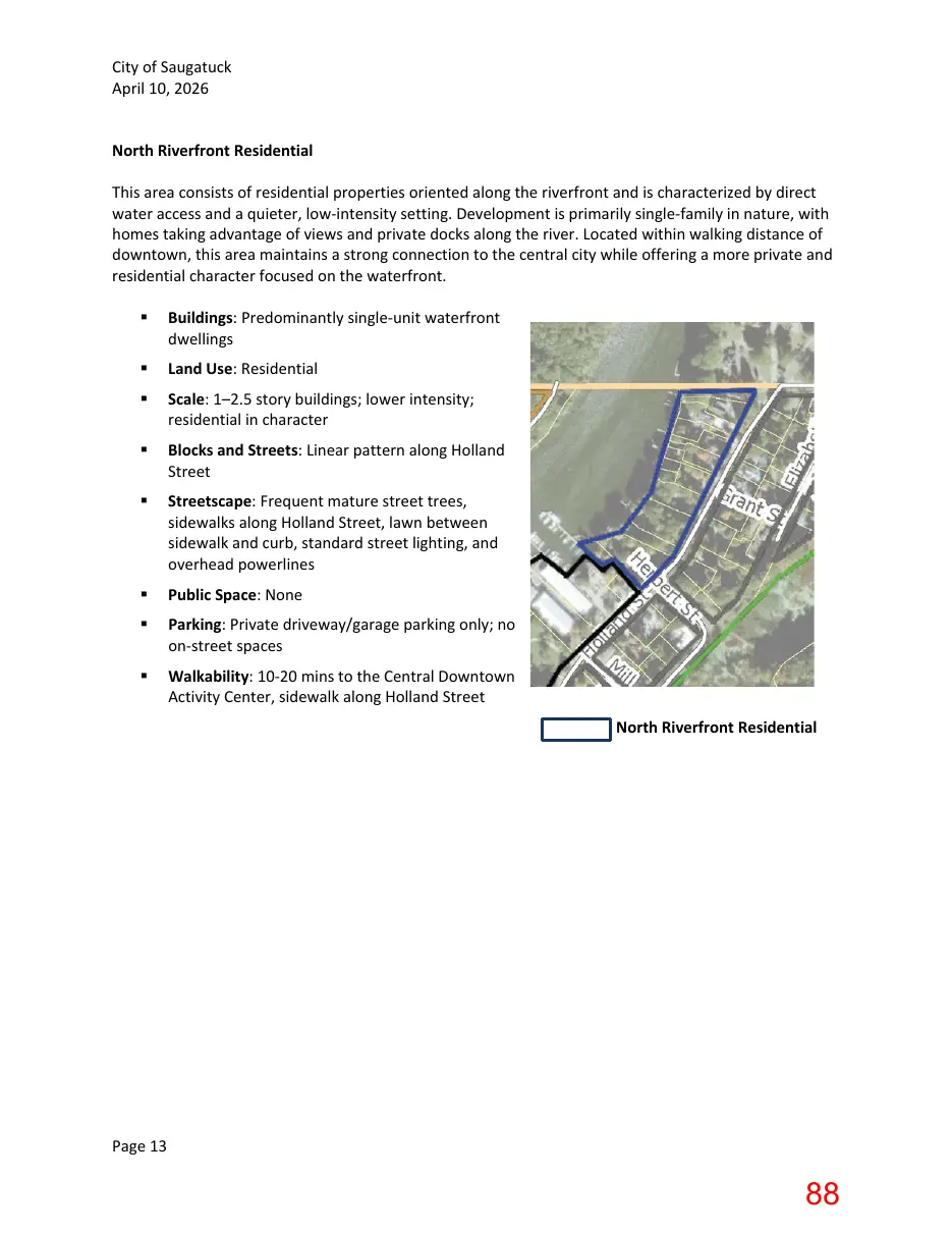
City of Saugatuck April 10, 2026 North Riverfront Residential This area consists of residential properties oriented along the riverfront and is characterized by direct water access and a quieter, low-intensity setting. Development is primarily single-family in nature, with homes taking advantage of views and private docks along the river. Located within walking distance of downtown, this area maintains a strong connection to the central city while offering a more private and residential character focused on the waterfront. §
Buildings: Predominantly single-unit waterfront dwellings
Land Use: Residential
Scale: 1–2.5 story buildings; lower intensity; residential in character
Blocks and Streets: Linear pattern along Holland Street
Streetscape: Frequent mature street trees, sidewalks along Holland Street, lawn between sidewalk and curb, standard street lighting, and overhead powerlines
Public Space: None
Parking: Private driveway/garage parking only; no on-street spaces
Walkability: 10-20 mins to the Central Downtown Activity Center, sidewalk along Holland Street North Riverfront Residential
Page 13
Page 89
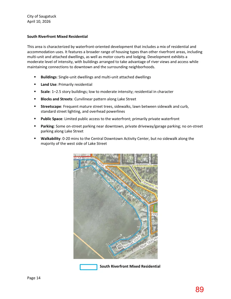
Text of page 89
City of Saugatuck April 10, 2026 South Riverfront Mixed Residential This area is characterized by waterfront-oriented development that includes a mix of residential and accommodation uses. It features a broader range of housing types than other riverfront areas, including multi-unit and attached dwellings, as well as motor courts and lodging. Development exhibits a moderate level of intensity, with buildings arranged to take advantage of river views and access while maintaining connections to downtown and the surrounding neighborhoods. §
Buildings: Single-unit dwellings and multi-unit attached dwellings
Land Use: Primarily residential
Scale: 1–2.5 story buildings; low to moderate intensity; residential in character
Blocks and Streets: Curvilinear pattern along Lake Street
Streetscape: Frequent mature street trees, sidewalks, lawn between sidewalk and curb, standard street lighting, and overhead powerlines
Public Space: Limited public access to the waterfront; primarily private waterfront
Parking: Some on-street parking near downtown, private driveway/garage parking; no on-street parking along Lake Street
Walkability: 0-20 mins to the Central Downtown Activity Center, but no sidewalk along the majority of the west side of Lake Street
South Riverfront Mixed Residential Page 14
Page 90
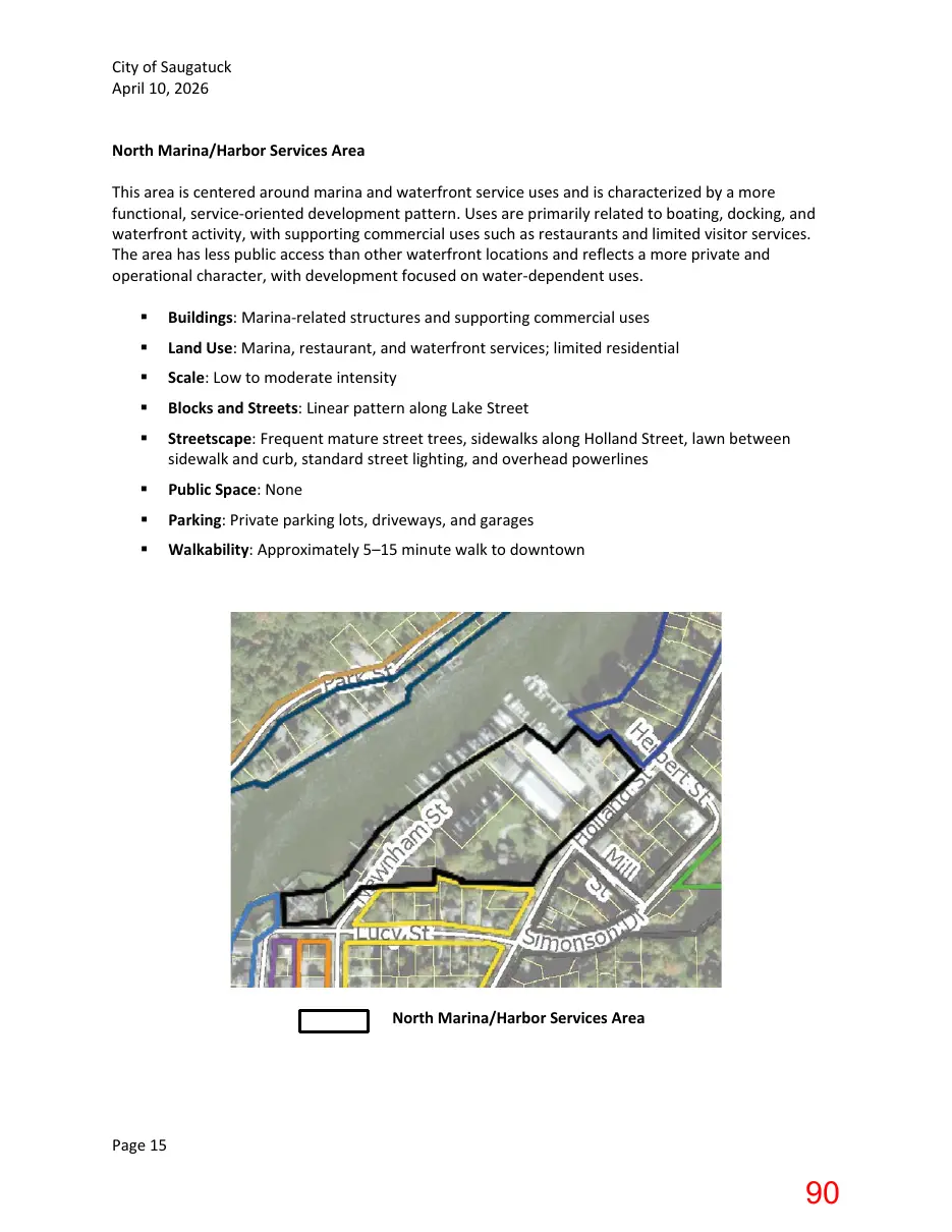
Text of page 90
City of Saugatuck April 10, 2026 North Marina/Harbor Services Area This area is centered around marina and waterfront service uses and is characterized by a more functional, service-oriented development pattern. Uses are primarily related to boating, docking, and waterfront activity, with supporting commercial uses such as restaurants and limited visitor services. The area has less public access than other waterfront locations and reflects a more private and operational character, with development focused on water-dependent uses. §
Buildings: Marina-related structures and supporting commercial uses
Land Use: Marina, restaurant, and waterfront services; limited residential
Scale: Low to moderate intensity
Blocks and Streets: Linear pattern along Lake Street
Streetscape: Frequent mature street trees, sidewalks along Holland Street, lawn between sidewalk and curb, standard street lighting, and overhead powerlines
Public Space: None
Parking: Private parking lots, driveways, and garages
Walkability: Approximately 5–15 minute walk to downtown
North Marina/Harbor Services Area
Page 15
Page 91
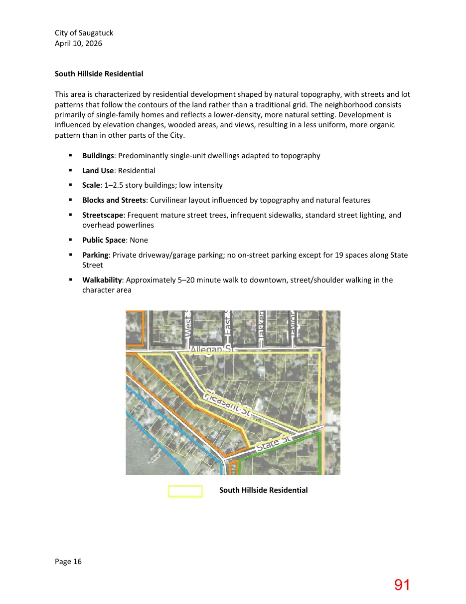
Text of page 91
City of Saugatuck April 10, 2026 South Hillside Residential This area is characterized by residential development shaped by natural topography, with streets and lot patterns that follow the contours of the land rather than a traditional grid. The neighborhood consists primarily of single-family homes and reflects a lower-density, more natural setting. Development is influenced by elevation changes, wooded areas, and views, resulting in a less uniform, more organic pattern than in other parts of the City. §
Buildings: Predominantly single-unit dwellings adapted to topography
Land Use: Residential
Scale: 1–2.5 story buildings; low intensity
Blocks and Streets: Curvilinear layout influenced by topography and natural features
Streetscape: Frequent mature street trees, infrequent sidewalks, standard street lighting, and overhead powerlines
Public Space: None
Parking: Private driveway/garage parking; no on-street parking except for 19 spaces along State Street
Walkability: Approximately 5–20 minute walk to downtown, street/shoulder walking in the character area
South Hillside Residential
Page 16
Page 92
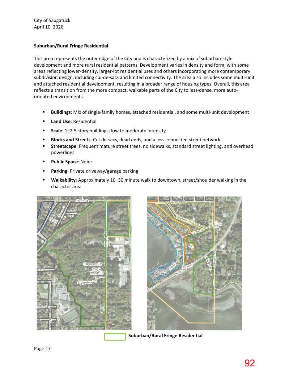
Text of page 92
City of Saugatuck April 10, 2026 Suburban/Rural Fringe Residential This area represents the outer edge of the City and is characterized by a mix of suburban-style development and more rural residential patterns. Development varies in density and form, with some areas reflecting lower-density, larger-lot residential uses and others incorporating more contemporary subdivision design, including cul-de-sacs and limited connectivity. The area also includes some multi-unit and attached residential development, resulting in a broader range of housing types. Overall, this area reflects a transition from the more compact, walkable parts of the City to less-dense, more autooriented environments. §
Buildings: Mix of single-family homes, attached residential, and some multi-unit development
Land Use: Residential
Scale: 1–2.5 story buildings; low to moderate intensity
Blocks and Streets: Cul-de-sacs, dead ends, and a less connected street network Streetscape: Frequent mature street trees, no sidewalks, standard street lighting, and overhead powerlines
Public Space: None
Parking: Private driveway/garage parking
Walkability: Approximately 10–30 minute walk to downtown, street/shoulder walking in the character area
Suburban/Rural Fringe Residential Page 17
Page 93
Text of page 93
City of Saugatuck April 10, 2026
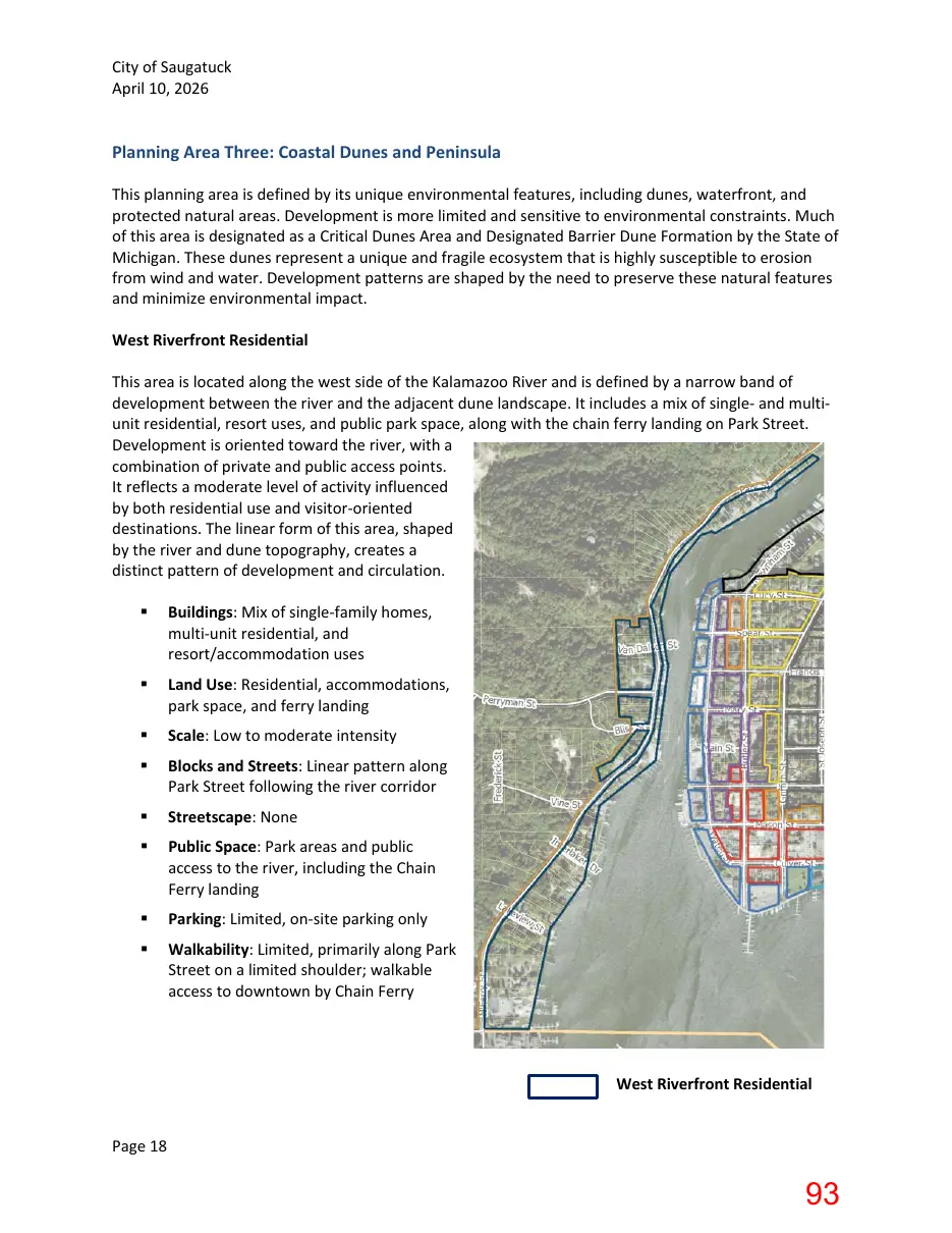
Planning Area Three: Coastal Dunes and Peninsula This planning area is defined by its unique environmental features, including dunes, waterfront, and protected natural areas. Development is more limited and sensitive to environmental constraints. Much of this area is designated as a Critical Dunes Area and Designated Barrier Dune Formation by the State of Michigan. These dunes represent a unique and fragile ecosystem that is highly susceptible to erosion from wind and water. Development patterns are shaped by the need to preserve these natural features and minimize environmental impact. West Riverfront Residential This area is located along the west side of the Kalamazoo River and is defined by a narrow band of development between the river and the adjacent dune landscape. It includes a mix of singleand multiunit residential, resort uses, and public park space, along with the chain ferry landing on Park Street. Development is oriented toward the river, with a combination of private and public access points. It reflects a moderate level of activity influenced by both residential use and visitor-oriented destinations. The linear form of this area, shaped by the river and dune topography, creates a distinct pattern of development and circulation. §
Buildings: Mix of single-family homes, multi-unit residential, and resort/accommodation uses
Land Use: Residential, accommodations, park space, and ferry landing
Scale: Low to moderate intensity
Blocks and Streets: Linear pattern along Park Street following the river corridor
Streetscape: None
Public Space: Park areas and public access to the river, including the Chain Ferry landing
Parking: Limited, on-site parking only
Walkability: Limited, primarily along Park Street on a limited shoulder; walkable access to downtown by Chain Ferry
West Riverfront Residential Page 18
Page 94
Text of page 94
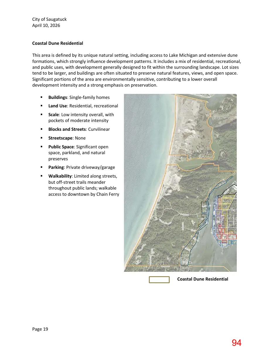
City of Saugatuck April 10, 2026 Coastal Dune Residential This area is defined by its unique natural setting, including access to Lake Michigan and extensive dune formations, which strongly influence development patterns. It includes a mix of residential, recreational, and public uses, with development generally designed to fit within the surrounding landscape. Lot sizes tend to be larger, and buildings are often situated to preserve natural features, views, and open space. Significant portions of the area are environmentally sensitive, contributing to a lower overall development intensity and a strong emphasis on preservation. §
Buildings: Single-family homes
Land Use: Residential, recreational
Scale: Low intensity overall, with pockets of moderate intensity
Blocks and Streets: Curvilinear
Streetscape: None
Public Space: Significant open space, parkland, and natural preserves
Parking: Private driveway/garage
Walkability: Limited along streets, but off-street trails meander throughout public lands; walkable access to downtown by Chain Ferry
Coastal Dune Residential
Page 19
Page 95
This page is a scanned image with no text layer. The PDF of these pages has it at full resolution.