
Workshop Agenda item 6A
Maple Street - Improvements Planning and Options
City Council Workshop, Wednesday, January 22, 2025
Download these 80 pages, 20.1 MB Whole packet, 136 pages, 50.9 MB
Page 2
Text of page 2
City Council Agenda Item Report FROM:
Ryan Cummins, City Manager
MEETING DATE:
January 22, 2025
SUBJECT:
Maple Street Improvements Planning and Options
DESCRIPTION: Maple Street and the underground water main are in need of replacement. City Council listed roads, asset management, and lead service line replacement as essential infrastructure priorities for the fiscal year. This work is also on the City’s capital improvement plan. In June, Council approved an engineering proposal to plan for the Maple Street improvements. Since that time, the City’s engineers have conducted an open house to gather public feedback, topographic surveys, meetings with Township officials, and developed estimates for various options, which include:
Road resurfacing or reconstruction Water main replacement (including replacement of services, some to inside the home/building) Drainage and stormwater management improvements Non-motorized improvements (widened shoulders, sidewalk, or similar)
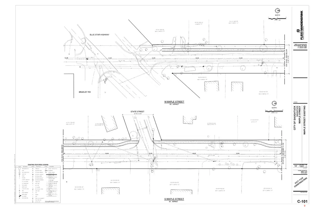
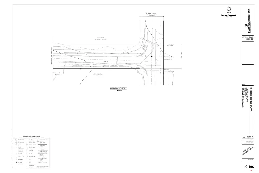
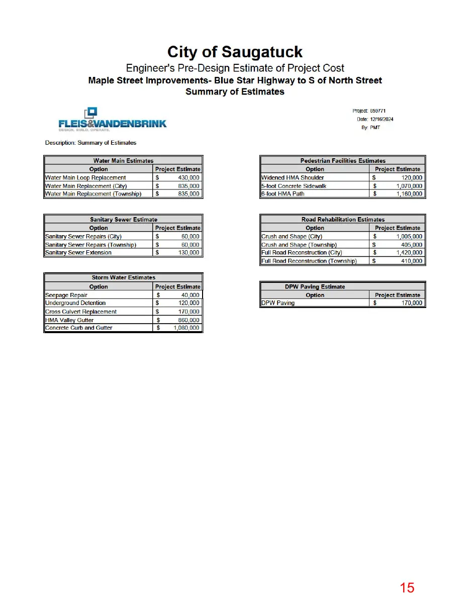
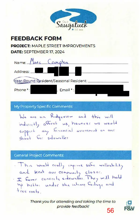
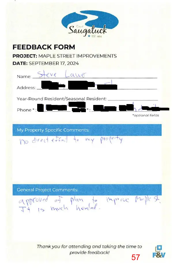
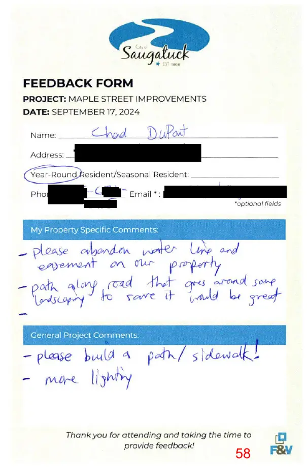
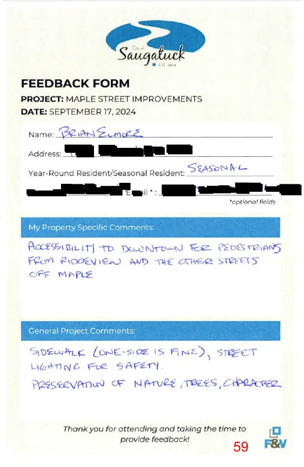
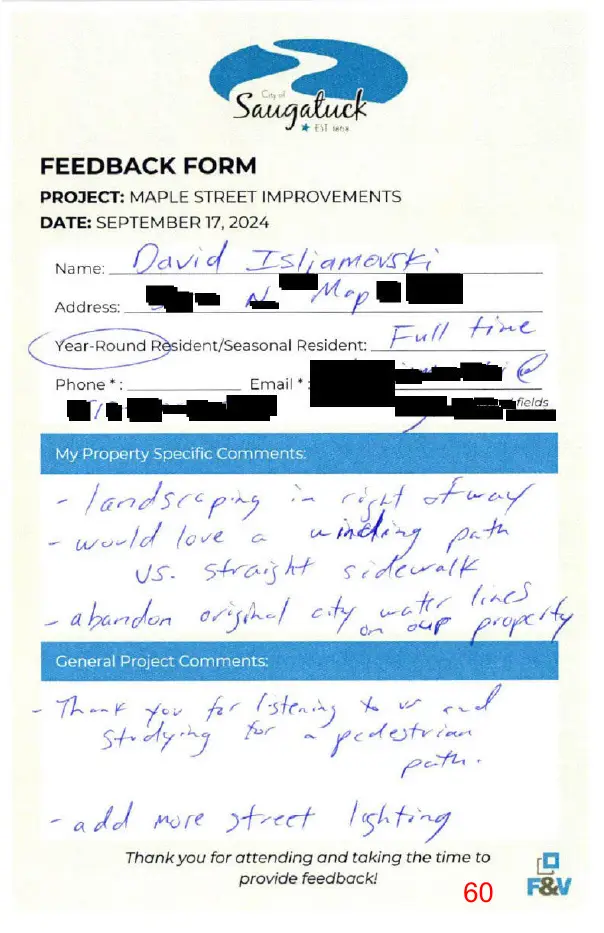
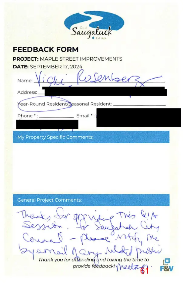
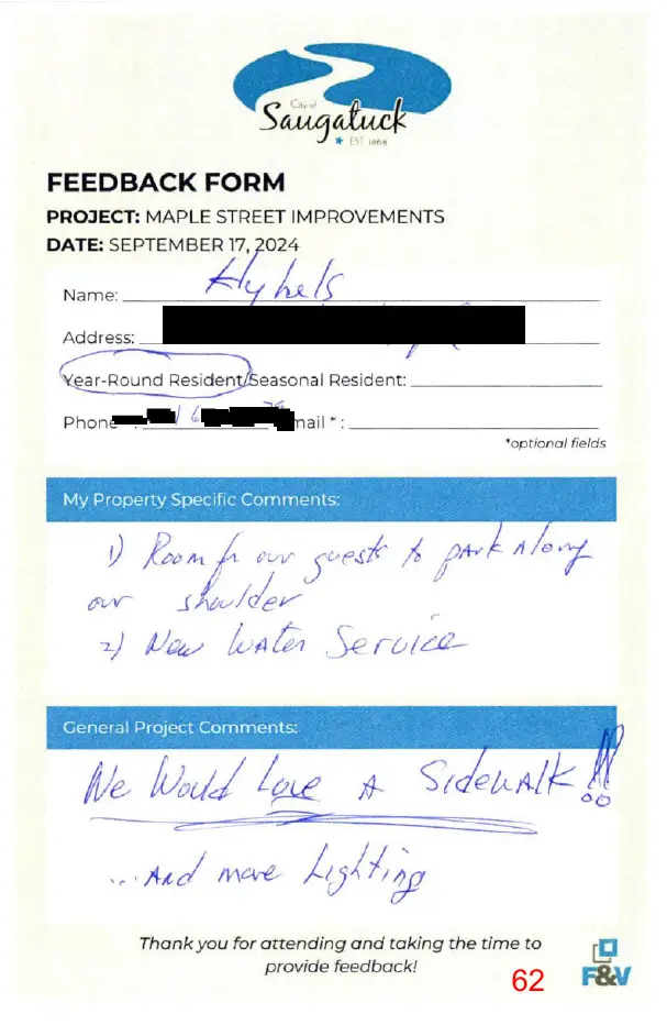
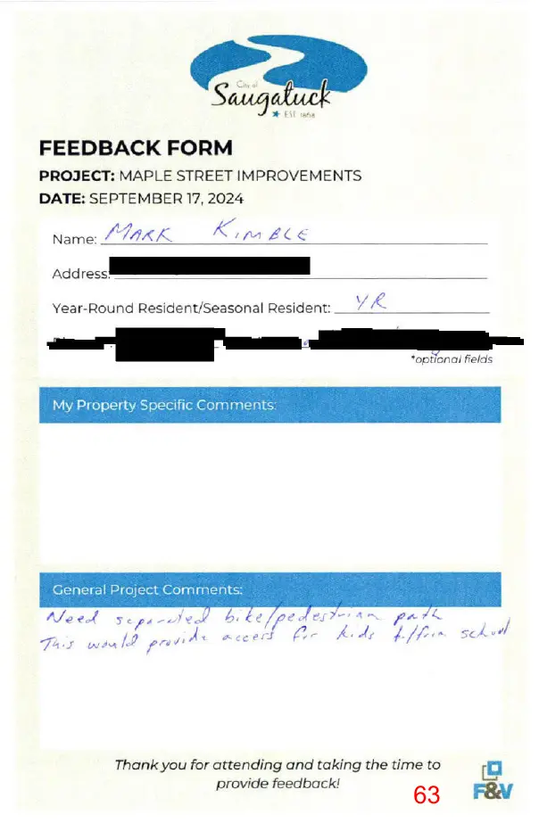
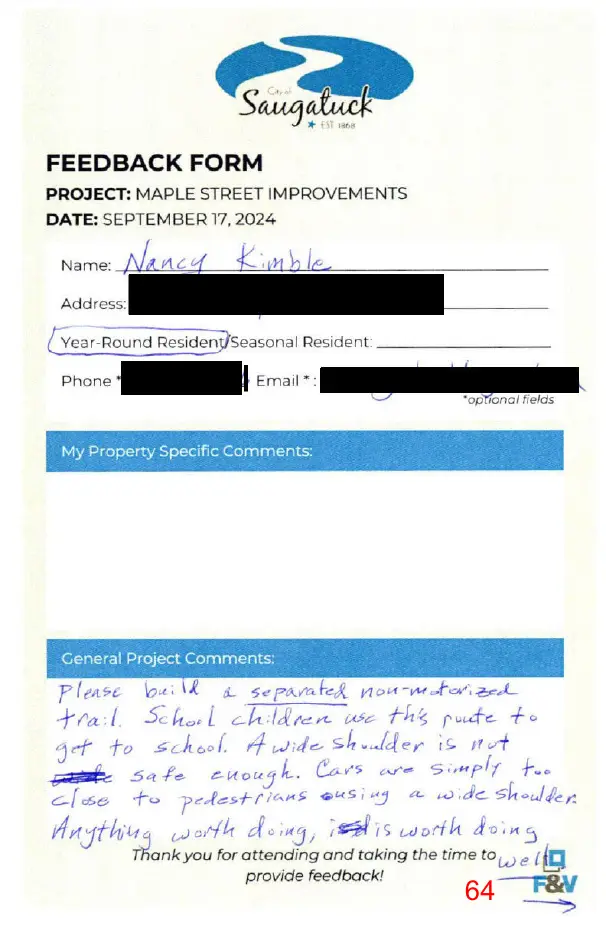
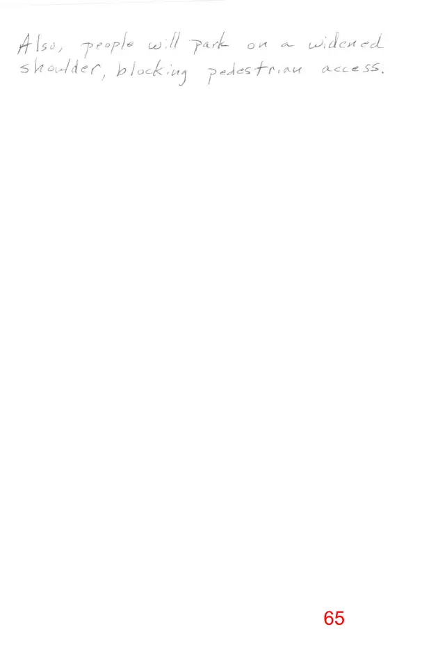
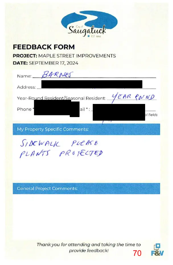
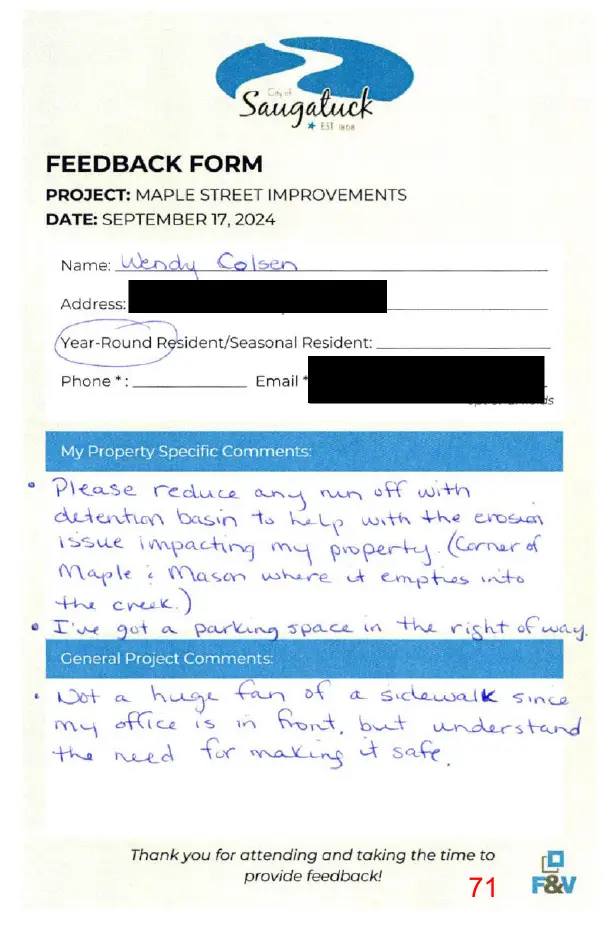
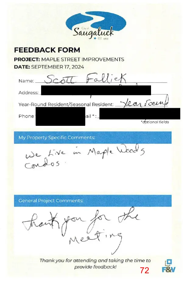
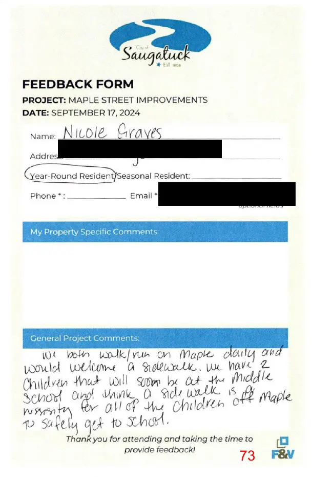
Attached is a planning report from the engineer as well as cost estimates for various options. Also attached is a copy of the public feedback forms, preliminary layout on sidewalk/path which was used to develop the cost estimates, and former report analyzing stormwater options for the area. The engineer will have a PowerPoint presentation for the meeting. The City has secured a $250,000 grant to help fund the roadwork. Current discussions with the Township include a 50/50 cost share to replace the water main and the side of the road the water main is under. Funding for the remainder of the project would come from a combination of streets, water-sewer, and general fund balances. The Township and City have also reached out to our elected officials in Lansing to discuss additional funding options.
Page 3
Text of page 3
Staff seeks Council feedback on the options so we can conduct further planning and take the next engineering steps. LEGAL REVIEW: The City Attorney will be at your meeting to answer any questions you may have. SAMPLE MOTION: N/A. Workshop item at this time.
Page 2
Page 4
Text of page 4
January 18, 2024 Via Email: rcummins@saugatuckcity.com Ryan Cummins, City Manager City of Saugatuck 102 Butler Street PO Box 86 Saugatuck, MI 49453 RE: Maple Street Improvements Planning (DRAFT for City Review/Feedback) Ryan, In coordination with the City of Saugatuck, Saugatuck Township, corridor residents and other stakeholders, Fleis & VandenBrink (F&V) has completed planning activities for various improvements on Maple Street between Blue Star Highway and the work completed in 2023 near North Street, approximately 1 mile in length. The purpose of this planning phase was to identify and evaluate options to help City Council to determine the scope of improvements to be made on Maple Street, looking toward design in 2025 and construction in 2026.
Background and Existing Conditions Maple Street serves as the part of the eastern border of the City, along with being a de facto detour whenever Blue Star Highway is closed for construction, accidents or other reasons. The Maple Street corridor includes significant public utility infrastructure that serves a wider area than the corridor itself – two wastewater lift stations with associated force mains, the City’s two municipal wells, regional stormwater infrastructure and others. A generational improvement project should consider all of these aspects. Water System Infrastructure The existing water main is a combination of 4-inch and 6-inch diameter cast iron pipe. Construction records are not available for much of the corridor, and its age is largely unknown. The water main has experienced several breaks in recent years, which result in costly emergency repairs, boil water advisories and traffic impacts. In recent years, a private water service was discovered to be connected to the system through the private water main that serves the Olde Mill Apartments, which has caused operational issues. As customers are reconnected to the new water main, it is anticipated that situation will be resolved with a direct connection to the public system. Fire hydrant locations and spacing will be coordinated with Kalamazoo Lake Sewer and Water Authority (KLSWA) from an operations and maintenance standpoint (hydrant flushing and other activities) and the Saugatuck Township Fire District (STFD). The City’s two wells are located west of Maple Street. A looped water main connects the wells to the distribution system at Maple Street to the east and along the east side of the high school to the west (the water main loop around the high school was replaced in recent years). This water main was identified as a priority for replacement in recent years, as it is expected to be similar age and construction as on Maple Street. The water main connection to Maple Street is through an easement on private property, while the access road to the wells uses the frontage of the City’s property.
Maple Street Planning Report
2960 Lucerne Dr SE, Suite 100 Grand Rapids, MI 49546 P: 616.977.1000 F: 616.977.1005 www.fveng.com
Page 5
Text of page 5
Ryan Cummins, City Manager │ City of Saugatuck │ January 18, 2024 Page 2 of 5
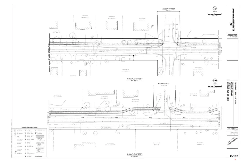
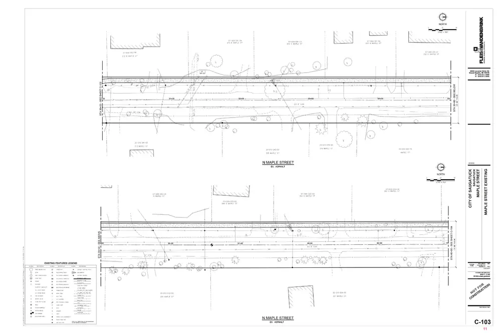
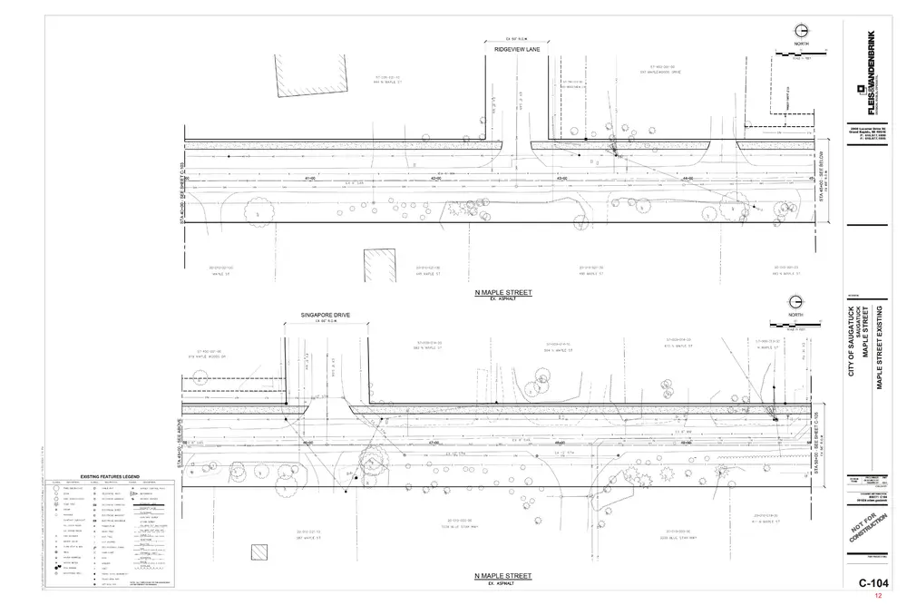
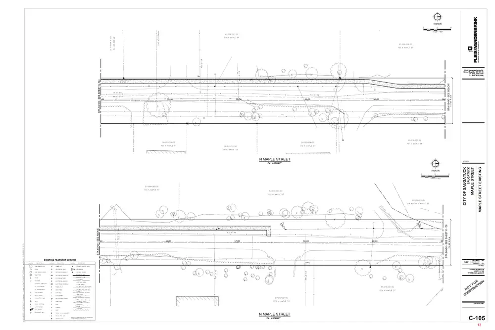
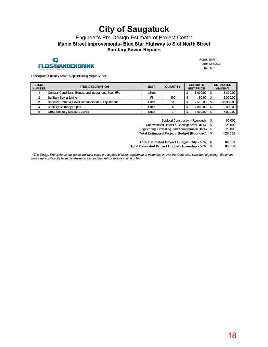
In 2024, the City received a Technical, Managerial, and Financial (TMF) Grant from the Michigan Department of Environment, Great Lakes and Energy (EGLE) to investigate the materials of its customers’ existing water services for which the material was unknown. The TMF project is ongoing and will not confirm 100% of the service materials, however, those results that are available have been incorporated here. Of the 18 City water services on Maple Street that have been physically exposed (“potholed”) as part of the TMF project, eight were found to be galvanized, four copper, and six plastic. EGLE’s current Lead and Copper Rule requires galvanized services to be replaced from the main to the home/business, as they are more likely to contain leaded “gooseneck” connections at the water main (or may have at some point in the past). The Township recently undertook a similar process and has reported similar results for their services in the corridor. Wastewater System Infrastructure Wastewater system infrastructure in the corridor includes sanitary sewer collection system piping, primarily 8inch diameter, a lift station on the west side of Maple Street north of Mason Street (with forcemain running south in Maple Street and west in Mason Street), a lift station on the east side of Maple Street south of North Street (with forcemain running north in Maple Street and west in North Street) and a pair of 16-inch forcemains that cross through the Maple Street corridor around 610 N Maple Street. Most of the corridor is served with sanitary sewer, with the exception of approximately 3 City parcels near North Street (Ridgewood Apartments are served through the lift station near North Street), which are assumed to be served by private septic systems. The existing wastewater infrastructure was evaluated in 2016 as a part of the KLSWA Stormwater, Asset Management and Wastewater (SAW) project. The sanitary sewer was televised, and the condition of the manholes was evaluated. The sewer was generally found to be in fair to good condition. Recommended repairs included lining one section of sanitary sewer and repairs to most of the manholes. Drainage System Infrastructure A series of cross culverts run underneath Maple Street, carrying stormwater runoff from the east side of the road to the west, following the topography of the area. They include a 12-inch crossing at Blue Star Highway, a 36-inch plus 12/15-inch crossing north of Mason Street (which is the end point of the Allegan County Drain Commissioner’s ongoing Blue Star Highway Drain project), a 15-inch crossing south of Ridgeview Lane, a 36inch crossing near 730 N Maple Street, and a 15-inch crossing just south of North Street (which was evaluated in 2022-2023 as part of that project). Visual evaluation was completed as part of this planning process and additional investigation is being considered, however, visual evaluation has found the observable portions of the culverts to be in an acceptable condition. The City has storm sewer infrastructure at many of the intersections within the corridor and sections along the west side of the road between Blue Star Highway and Mason Street with an outfall in the northwest quadrant of the Mason Street intersection, serving portions of Pleasant Street, Allegan Street, Mason Street and Maple Street itself. Between Mason Street and North Street, storm sewer infrastructure is limited to the area between Maple Woods Drive and north of Singapore Drive, which primarily serves the corridor itself. Notably, the City’s outfall at the northwest quadrant of Mason Street outfalls to an open channel (small stream) that runs through private properties to the northwest. F&V completed a drainage study in 2022 (letter report dated November 22, 2022) that reviewed bank erosion concerns in the open channel and presented a range of mitigation options, which have been further evaluated and incorporated in this planning process. The south approach of Maple Street at Blue Star Highway has experienced seasonal seepage through the pavement for a number of years, which is a maintenance concern and tends to prematurely deteriorate the road. A similar condition existed on Campbell Road near Park/Ferry Street and was resolved with additional underdrain. The current roadway is not curbed, either with asphalt or concrete. Water sheds off the road into the adjacent green areas and in some cases shallow swales or ditches before entering the storm sewer system, where it exists. Roadway Infrastructure The asphalt pavement received a Paser Rating of 2 (“very poor”) in the 2022 Paser Rating study and has deteriorated further since that time. The Department of Public Works (DPW) regularly patches potholes, but the additional traffic during closure of Blue Star Highway in 2024 for roundabout construction highlighted the
Maple Street Planning Report
Page 6
Text of page 6
Ryan Cummins, City Manager │ City of Saugatuck │ January 18, 2024 Page 3 of 5
deteriorated condition of the roadway on Maple Street. The asphalt is beyond its useful life and needs to be replaced, along with improvement of the base material. Non-Motorized Infrastructure Finally, the Maple Street corridor currently has no non-motorized infrastructure, and the pavement is narrow, making walking or other non-motorized travel problematic. The City and Township have sidewalk on the north side of Allegan Street and are working toward constructing the Blue Star Trail, which is anticipated to cross Maple Street along the north side of Blue Star Highway. No other cross streets in the corridor currently have non-motorized facilities. Other Infrastructure The Maple Street corridor serves as secondary/rear access for the City’s DPW facilities at 3338 Blue Star Highway and the STFD facility at 3342 Blue Star Highway. Configuration and construction of the drive approaches for both facilities will be coordinated with the appropriate personnel. The asphalt pavement at the DPW facility is in poor condition and has been considered as part of planning activities.
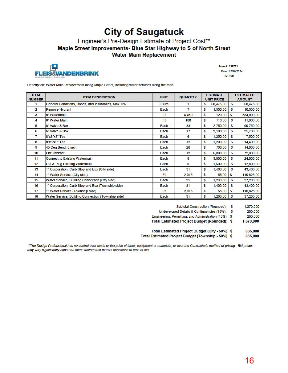
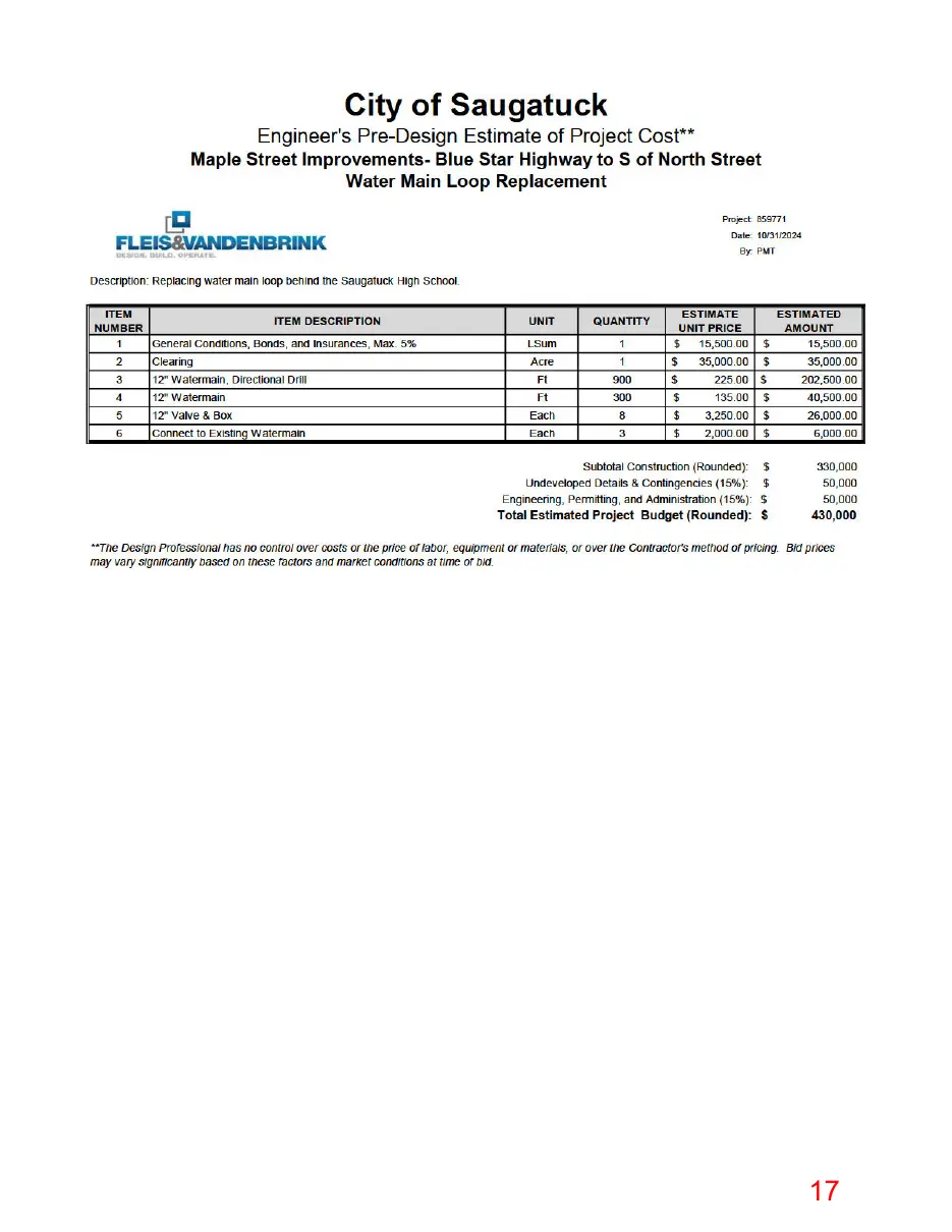
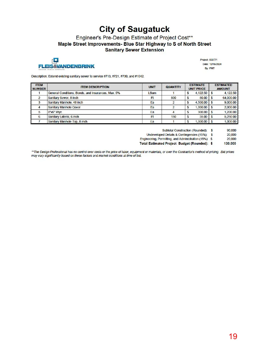
Evaluation of Options F&V considered all of the above concerns during this planning process and identified improvement options for the City’s consideration. Water System Infrastructure The existing 4-inch and 6-inch water main should be replaced with an 8-inch water main. While 6-inch is the minimum allowable diameter allowed by EGLE for public water main, 8-inch is the recommended minimum size, as it provides significantly greater capacity for fire flows with just a nominal increase in cost. An updated water agreement amongst the community members of KLSWA is in process. In the meantime, F&V met with representatives from the City and the Township to discuss a 50-50 cost sharing for the water main and related infrastructure (fittings, valves and hydrants) in the portion of the corridor that has City parcels on the west side and Township parcels on the east side (near North Street, the City Limits cover both sides of Maple Street). A similar cost sharing for one lane of road restoration was also discussed, as that work is required for water main replacement. The details will need to be finalized, but based on the discussion, cost estimates have been broken down using those assumptions, as well as each community being responsible for water service replacements for customers within its own jurisdiction. This breakdown is in alignment with the City’s recent project on Cambell Road with Douglas, in terms of precedent. Another item in the ongoing water system agreement discussions is the development of standard specifications amongst the KLSWA member communities. The Maple Street project could be an opportunity for determining/using those standards. An estimate has provided for replacing the water main loop for the well field between Maple Street and the high school loop. In light of the ongoing discussions related to ownership of this infrastructure, we would recommend constructing a simple stub for future relocation of the connection at Maple Street (relocating it from the easement to follow the access road) and addressing replacement of the loop itself with a future project. Wastewater System Infrastructure In accordance with the recommendations from the KLSWA SAW project, cost estimates have been prepared for a section of sewer lining and manhole repairs. Similar to the water main, it is assumed that sanitary sewer and manhole repairs would be shared costs, as they all occur in the portion of the corridor with City parcels on the west side and Township on the east. A separate estimate has been prepared for extending 8-inch sanitary sewer to serve 721, 730, and 1042 N Maple Street, all of which are located in the City (1039 is Ridgewood Apartments, which is already served and the parcel north of 1042 is City-owned property, primarily Goshorn Creek floodplain area not suitable for development). With only three parcels, the cost per parcel may make gravity sewer extension cost prohibitive. Instead, the City could consider extending smaller diameter (~2-inch) and shallower pipe for future grinder/ejector pump connections (how 713 N Maple is connected to the system), which would be a much more cost-effective solution.
Maple Street Planning Report
Page 7
Text of page 7
Ryan Cummins, City Manager │ City of Saugatuck │ January 18, 2024 Page 4 of 5
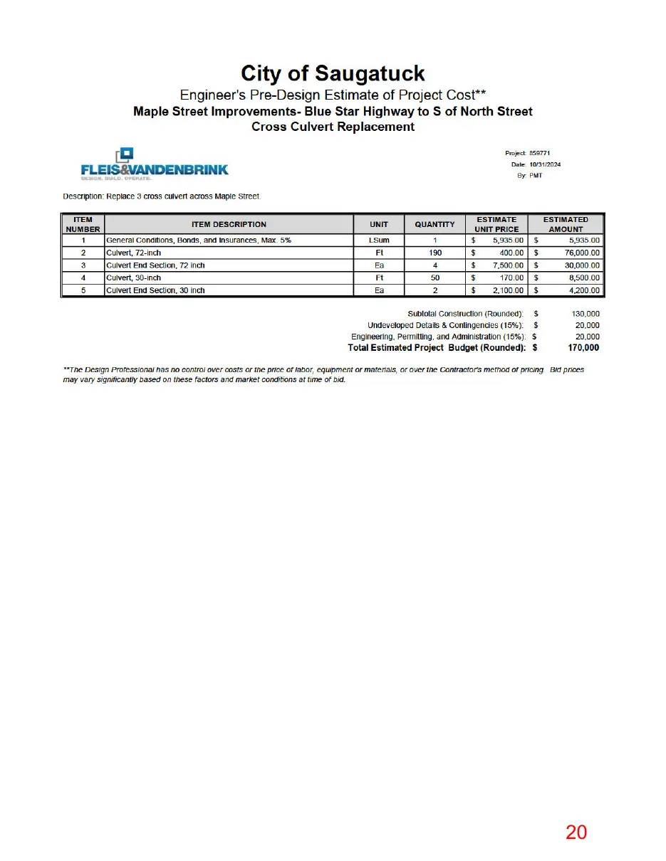
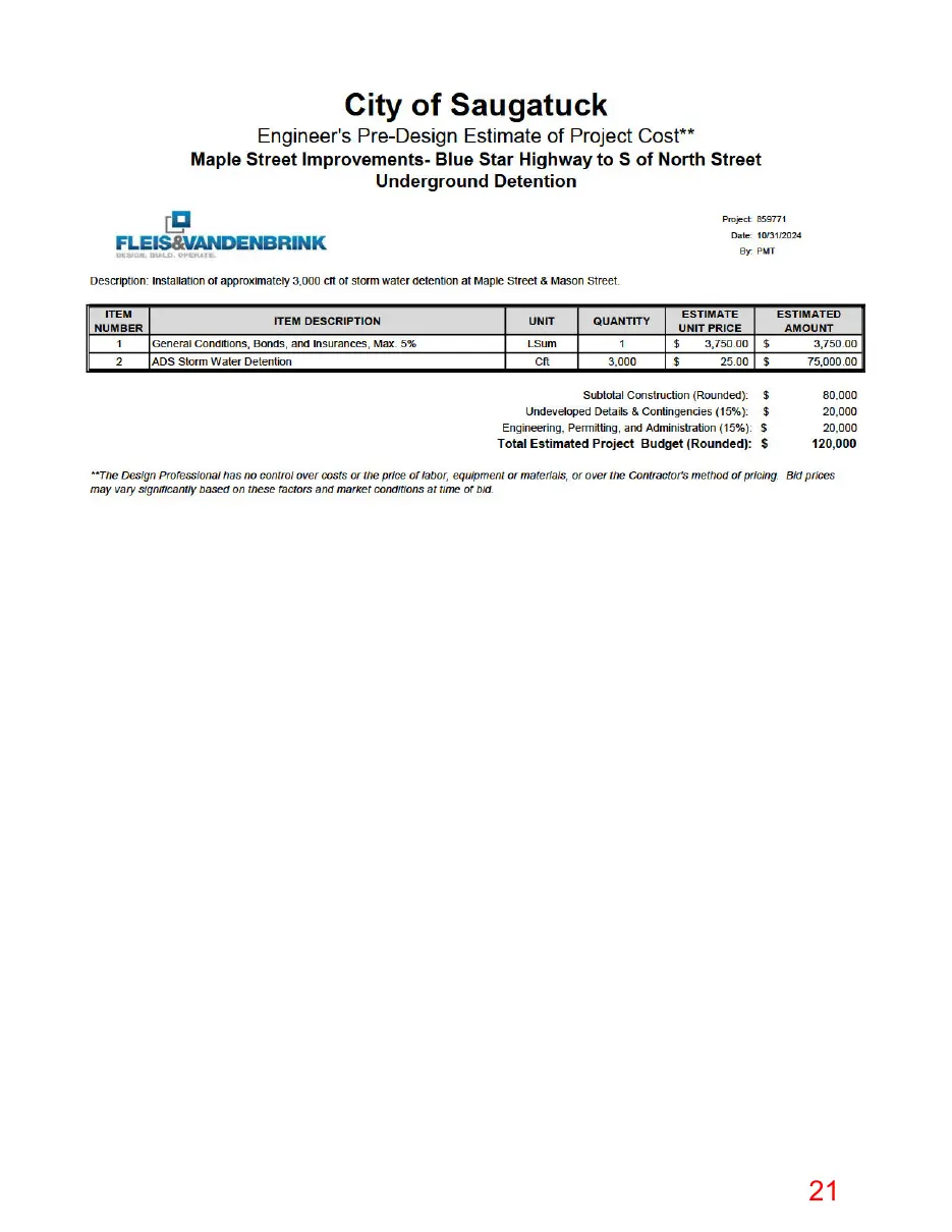
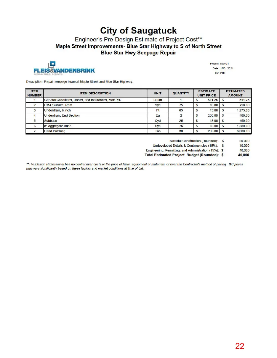
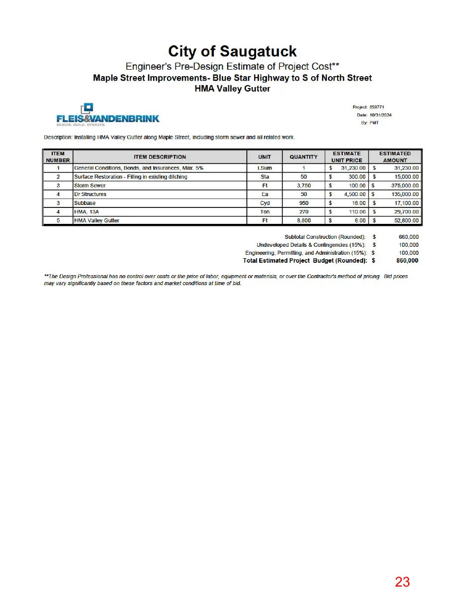
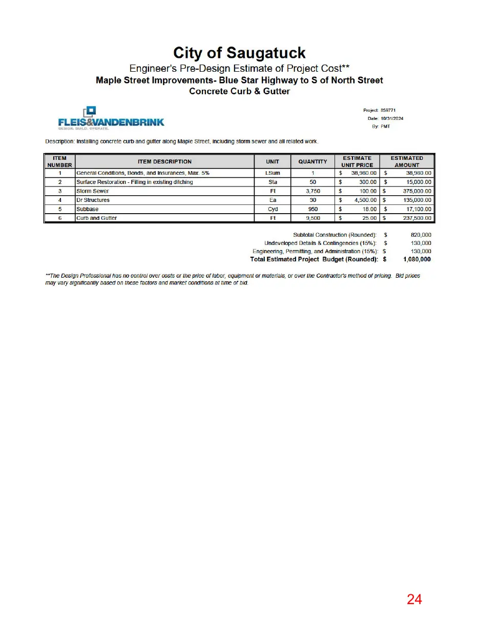
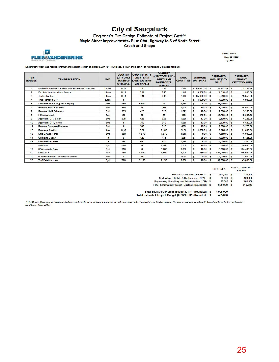
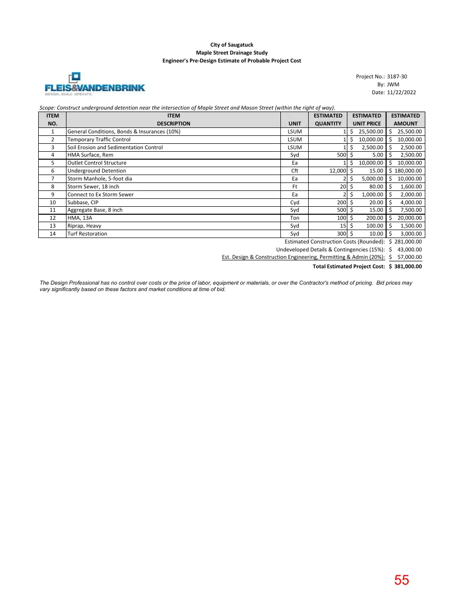
Drainage System Infrastructure Visual evaluation of the culvert crossings was completed as part of the planning process, to the extent they are observable from the ends of the pipe. Additional evaluation with sewer televising or other technology is currently being discussed with the DPW. Based on the visual evaluation, the cross culverts appear to be in serviceable condition. It is anticipated that the cross culverts could be lined or other repairs made short of full replacement, if conditions warrant at some point. We have prepared cost estimates for replacement for reference. Storm sewer in the corridor is relatively new. Adjustment of structures and other nominal modifications are anticipated as part of road improvements and are included in those estimates. To help mitigate peak flows at the Mason Street storm sewer outfall (and lower the erosive forces downstream), we have prepared a cost estimate for constructing underground detention at the intersection of Maple Street and Mason Street. Property acquisition required for a traditional detention pond proved to be cost-prohibitive and redirecting the flow is anticipated to have environmental and maintenance challenges, along with potentially causing or exacerbating similar erosion issues elsewhere. A cost estimate has been prepared to address the seepage issues on the south side of Blue Star Highway. Because it is not directly contiguous with the rest of the project, the City could consider addressing the seepage as part of a future or standalone project without affecting the other work in the corridor. In conjunction with road improvements, the City could curb the road, either with concrete curb and gutter or asphalt valley gutter. To realize the full benefit of curbing the roadway, a series of catch basins (or leach basins) and storm sewer would be required (the alternative would be a series of spillways to improved swales/ditches. A public open house was held on September 17, 2024. A few drainage concerns were raised, but they were not generally ones that curbing would directly address. Furthermore, curbing the road improves the efficiency of transporting stormwater. Similar improvements on other streets in the area are understood to have contributed to the current concerns at the Mason Street outfall. Cost estimates for curbing, either with concrete or asphalt, have been provided, but based on cost and other factors are likely not warranted. Roadway Infrastructure Replacement of the water main will require reconstructing the west lane of the road, which involves installing new sand subbase (typically 12 inches) and gravel aggregate base (typically 8 inches) prior to asphalt paving. The east lane could be reconstructed to match the west, or a crush and shape strategy could be used. Crush and shape involves grinding up the existing pavement to supplement the existing base materials and placing new asphalt on the improved base. Crush and shape will raise the road elevation a few inches. With less earthwork required, crush and shape is less costly than full reconstruction, while still improving the base strength. This was the strategy used on the recent Campbell Road project. Allegan Street between Lake Street and Elizabeth Street is a recent example of a full reconstruction. Cost estimates have been provided for both options and we consider them to be “good” and “better”. A 3-inch asphalt thickness is common of residential streets. Cost estimates include 4 inches for Maple Street, due to DPW and STFD and other non-residential properties along the corridor. The assumed cross section for either option is a 10-foot travel lane, with 1-foot asphalt shoulders and 2-foot gravel shoulders. Striping the shoulder helps to make the road feel narrower to drivers, a traffic calming strategy for controlling speeds that tend to increase on new, smooth asphalt. The City received $250,000 in funding from the Michigan Department of Transportation’s Category B (Villages and Small Cities) program, which will offset some of the roadway costs. The application for that funding assumed a crush and shape strategy would be used for the east side of the road, but we anticipate MDOT would be open to the reconstruction option as well. Non-Motorized Infrastructure The addition of non-motorized infrastructure has been a focus of the planning process and was the most common topic of conversation at the open house. Cost estimates have been developed for three options (a combination could be used also). A widened shoulder could be a 3-foot asphalt shoulder on the west side of Maple Street (the width selected for Campbell Road), which is what the cost estimate reflects. It could also be widened shoulder on the east side or
Maple Street Planning Report
Page 8
Text of page 8
Ryan Cummins, City Manager │ City of Saugatuck │ January 18, 2024 Page 5 of 5
both sides. A widened shoulder has the advantage of being the lowest cost option, both in terms of the initial capital cost and the long-term maintenance cost (the asphalt can be plowed, resurfaced, etc. along with the rest of the road). One disadvantage is that it places non-motorized corridor users directly adjacent to the vehicle lane, though it would still be an improvement. Another disadvantage is the wider pavement potentially producing increased speeds. A standard 5-foot concrete sidewalk could be constructed on the west side of Maple Street. Sidewalks tend to be constructed in straight segments but can also be strategically curved around trees and other obstructions to limit the impact, which is one of the concerns commonly raised at the open house. An asphalt path could also be constructed. The practical minimum pavement width (based on readily available asphalt paving equipment) is approximately 6 feet, which is what has been used in the cost estimate. The slightly wider section has proportionally greater impact, but asphalt tends to be more conducive to curved alignments around obstructions. The additional width also more conducive to bicycle traffic (some communities restrict bicycle riding on sidewalks). Removals, grading, retaining walls and fencing are anticipated for either a sidewalk or path, depending on the northern limits of construction. For the purposes of the estimates, the northern end point has assumed to be the Ridgewood Apartments entrance area. All these options were discussed at the open house. From the responses received during and following the open house, approximately 7% of respondents wanted no pedestrian facility, 10% wanted a widened shoulder, 34% wanted a sidewalk, and 7% wanted an HMA shared use path. 21% wanted some version of a pedestrian facility but had no opinion on which of the options occurred. 21% of respondents had no opinion on the matter. All but one of the 29 responses received were from year-round residents. Other Infrastructure As part of road improvements, some portion of all drive approaches will need to be rebuilt, including the STFD approach. Sight distance for that approach is impacted by a large tree (approximately 5-foot diameter) directly adjacent to the road. Its proximity to the vehicle lane makes the tree a hazard to the road itself. Removal of that tree is recommended. Repaving the parking lot and access roads at the DPW facility has been on the DPW’s “wish list” for some time. With the DPW property being adjacent to the work occurring on Maple Street, it would be economically efficient to including crushing, shaping and resurfacing those areas as a part of this project. A cost estimate has been provided for Council’s consideration.
Conclusion Cost estimates for the various options presented are attached. The cost estimates are presented in a “menu” format to allow the City to pick which options they want to move forward with vs. which options they want to forgo. We will prepare a proposal for design phase engineering services when the project scope has been determined. We appreciate the opportunity to assist you with this study and look forward to discussing it with City Council and other stakeholders. In the meantime, please feel free to contact us with any questions. Sincerely, FLEIS & VANDENBRINK
Jonathan Moxey, P.E. Project Manager Cc:
Peter Tierney, P. E. Project Engineer
Scott Herbert, City of Saugatuck, Public Works Superintendent (scott@saugatuckcity.com)
Maple Street Planning Report
Page 9
This page is a scanned image with no text layer. The PDF of these pages has it at full resolution.
Page 10
This page is a scanned image with no text layer. The PDF of these pages has it at full resolution.
Page 11
This page is a scanned image with no text layer. The PDF of these pages has it at full resolution.
Page 12
This page is a scanned image with no text layer. The PDF of these pages has it at full resolution.
Page 13
This page is a scanned image with no text layer. The PDF of these pages has it at full resolution.
Page 14
This page is a scanned image with no text layer. The PDF of these pages has it at full resolution.
Page 15
This page is a scanned image with no text layer. The PDF of these pages has it at full resolution.
Page 16
This page is a scanned image with no text layer. The PDF of these pages has it at full resolution.
Page 17
This page is a scanned image with no text layer. The PDF of these pages has it at full resolution.
Page 18
This page is a scanned image with no text layer. The PDF of these pages has it at full resolution.
Page 19
This page is a scanned image with no text layer. The PDF of these pages has it at full resolution.
Page 20
This page is a scanned image with no text layer. The PDF of these pages has it at full resolution.
Page 21
This page is a scanned image with no text layer. The PDF of these pages has it at full resolution.
Page 22
This page is a scanned image with no text layer. The PDF of these pages has it at full resolution.
Page 23
This page is a scanned image with no text layer. The PDF of these pages has it at full resolution.
Page 24
This page is a scanned image with no text layer. The PDF of these pages has it at full resolution.
Page 25
This page is a scanned image with no text layer. The PDF of these pages has it at full resolution.
Page 26
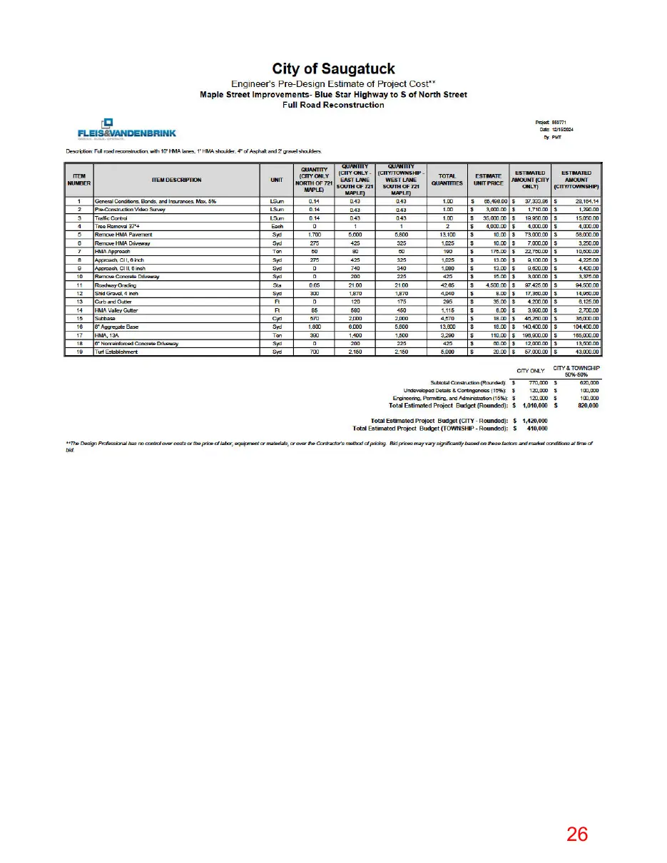
This page is a scanned image with no text layer. The PDF of these pages has it at full resolution.
Page 27
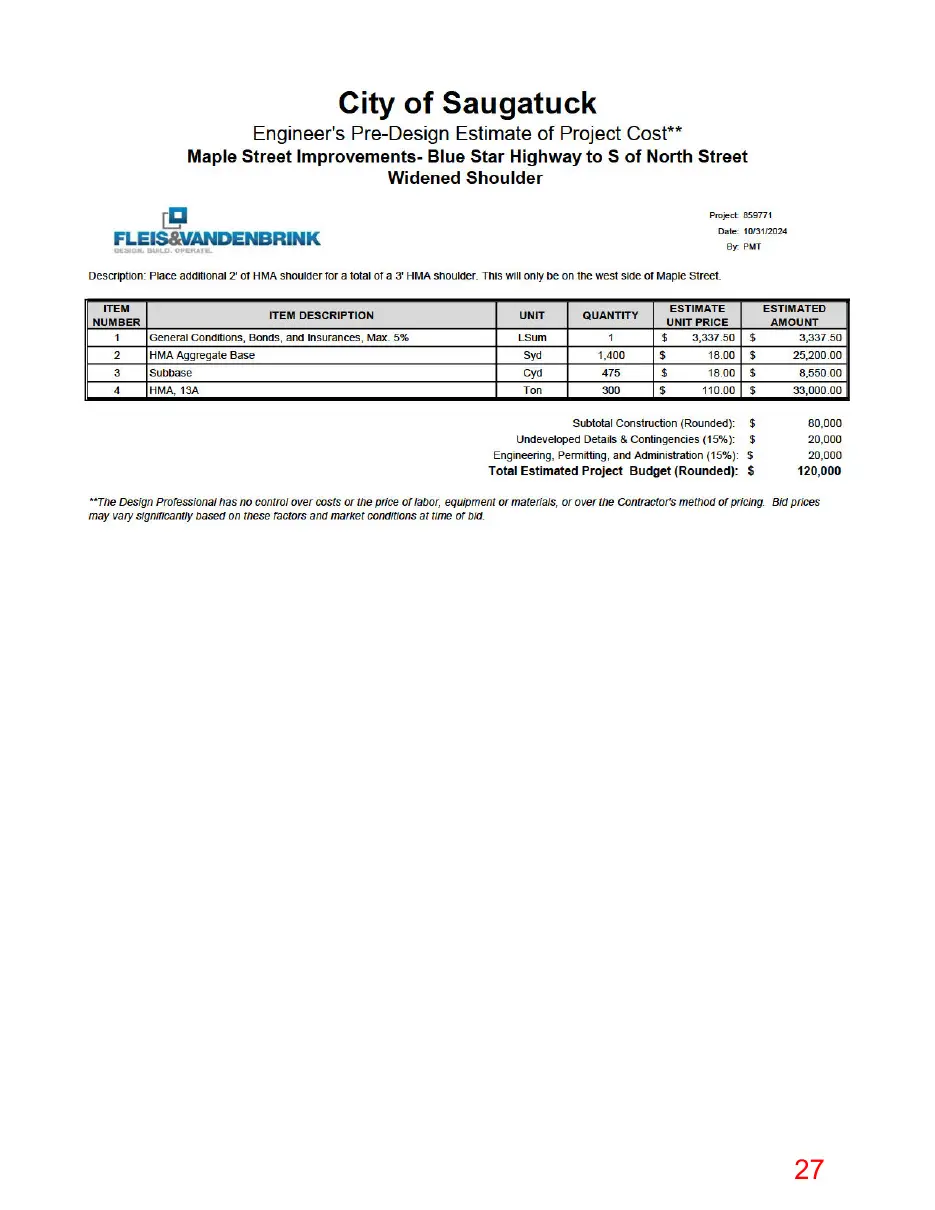
This page is a scanned image with no text layer. The PDF of these pages has it at full resolution.
Page 28
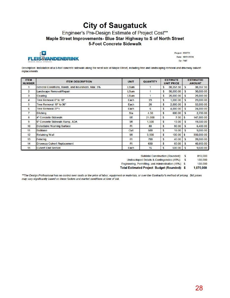
This page is a scanned image with no text layer. The PDF of these pages has it at full resolution.
Page 29
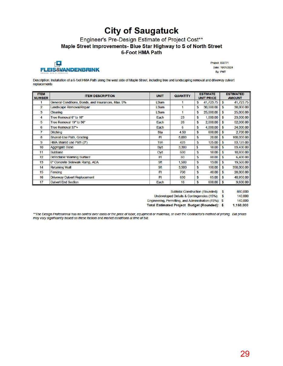
This page is a scanned image with no text layer. The PDF of these pages has it at full resolution.
Page 30
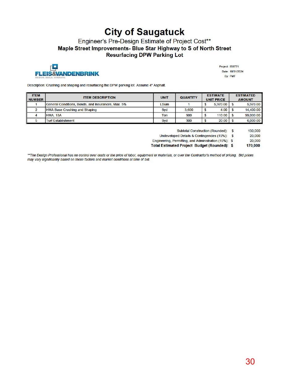
This page is a scanned image with no text layer. The PDF of these pages has it at full resolution.
Page 31
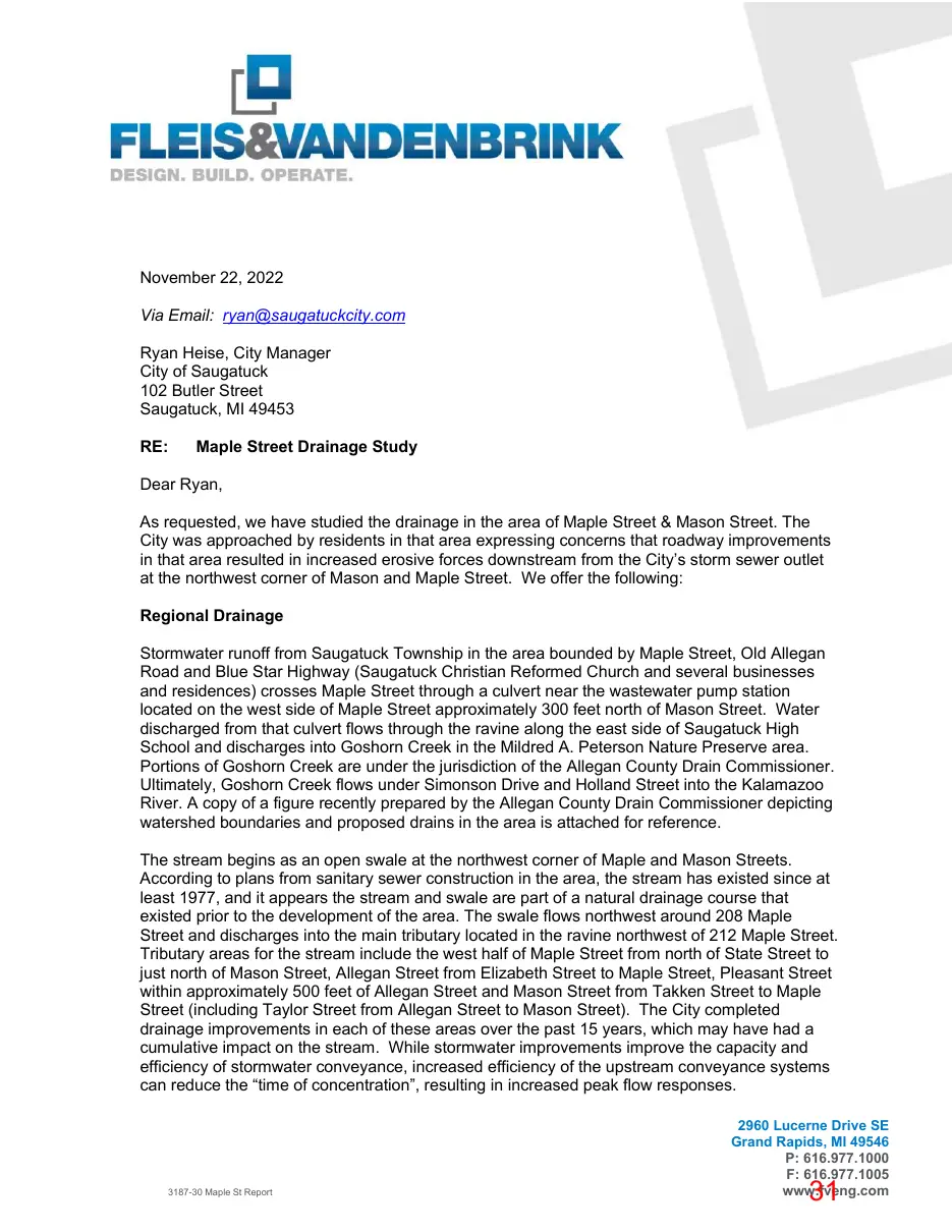
Text of page 31
November 22, 2022 Via Email: ryan@saugatuckcity.com Ryan Heise, City Manager City of Saugatuck 102 Butler Street Saugatuck, MI 49453 RE:
Maple Street Drainage Study
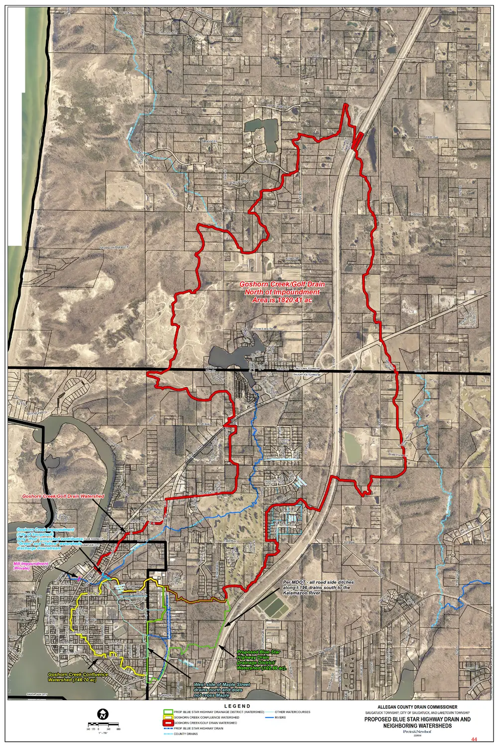
Dear Ryan, As requested, we have studied the drainage in the area of Maple Street & Mason Street. The City was approached by residents in that area expressing concerns that roadway improvements in that area resulted in increased erosive forces downstream from the City’s storm sewer outlet at the northwest corner of Mason and Maple Street. We offer the following: Regional Drainage Stormwater runoff from Saugatuck Township in the area bounded by Maple Street, Old Allegan Road and Blue Star Highway (Saugatuck Christian Reformed Church and several businesses and residences) crosses Maple Street through a culvert near the wastewater pump station located on the west side of Maple Street approximately 300 feet north of Mason Street. Water discharged from that culvert flows through the ravine along the east side of Saugatuck High School and discharges into Goshorn Creek in the Mildred A. Peterson Nature Preserve area. Portions of Goshorn Creek are under the jurisdiction of the Allegan County Drain Commissioner. Ultimately, Goshorn Creek flows under Simonson Drive and Holland Street into the Kalamazoo River. A copy of a figure recently prepared by the Allegan County Drain Commissioner depicting watershed boundaries and proposed drains in the area is attached for reference. The stream begins as an open swale at the northwest corner of Maple and Mason Streets. According to plans from sanitary sewer construction in the area, the stream has existed since at least 1977, and it appears the stream and swale are part of a natural drainage course that existed prior to the development of the area. The swale flows northwest around 208 Maple Street and discharges into the main tributary located in the ravine northwest of 212 Maple Street. Tributary areas for the stream include the west half of Maple Street from north of State Street to just north of Mason Street, Allegan Street from Elizabeth Street to Maple Street, Pleasant Street within approximately 500 feet of Allegan Street and Mason Street from Takken Street to Maple Street (including Taylor Street from Allegan Street to Mason Street). The City completed drainage improvements in each of these areas over the past 15 years, which may have had a cumulative impact on the stream. While stormwater improvements improve the capacity and efficiency of stormwater conveyance, increased efficiency of the upstream conveyance systems can reduce the “time of concentration”, resulting in increased peak flow responses.
3187-30 Maple St Report
2960 Lucerne Drive SE Grand Rapids, MI 49546 P: 616.977.1000 F: 616.977.1005 www.fveng.com
Page 32
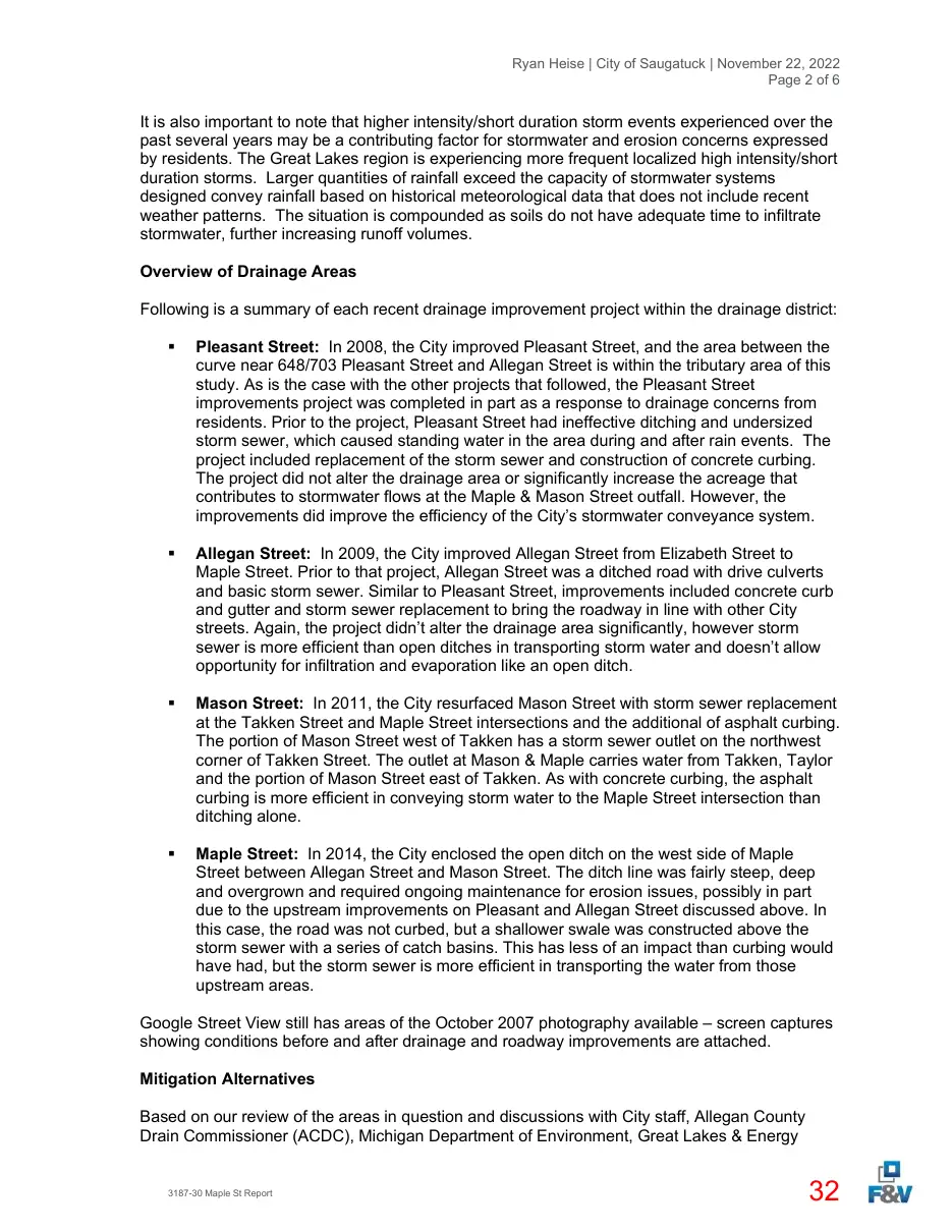
Text of page 32
Ryan Heise | City of Saugatuck | November 22, 2022 Page 2 of 6
It is also important to note that higher intensity/short duration storm events experienced over the past several years may be a contributing factor for stormwater and erosion concerns expressed by residents. The Great Lakes region is experiencing more frequent localized high intensity/short duration storms. Larger quantities of rainfall exceed the capacity of stormwater systems designed convey rainfall based on historical meteorological data that does not include recent weather patterns. The situation is compounded as soils do not have adequate time to infiltrate stormwater, further increasing runoff volumes. Overview of Drainage Areas Following is a summary of each recent drainage improvement project within the drainage district:
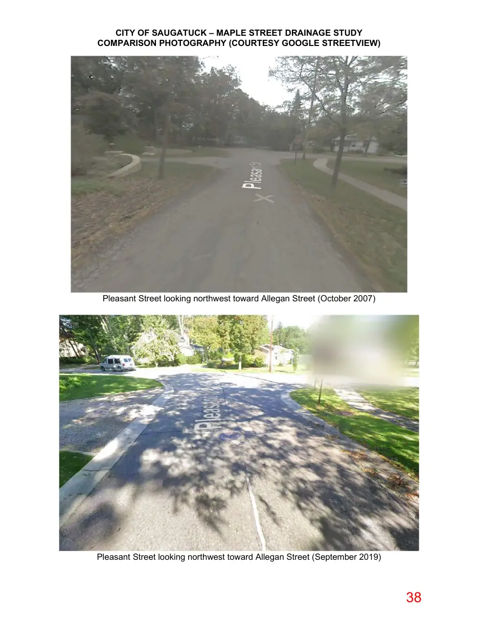
Pleasant Street: In 2008, the City improved Pleasant Street, and the area between the curve near 648/703 Pleasant Street and Allegan Street is within the tributary area of this study. As is the case with the other projects that followed, the Pleasant Street improvements project was completed in part as a response to drainage concerns from residents. Prior to the project, Pleasant Street had ineffective ditching and undersized storm sewer, which caused standing water in the area during and after rain events. The project included replacement of the storm sewer and construction of concrete curbing. The project did not alter the drainage area or significantly increase the acreage that contributes to stormwater flows at the Maple & Mason Street outfall. However, the improvements did improve the efficiency of the City’s stormwater conveyance system.
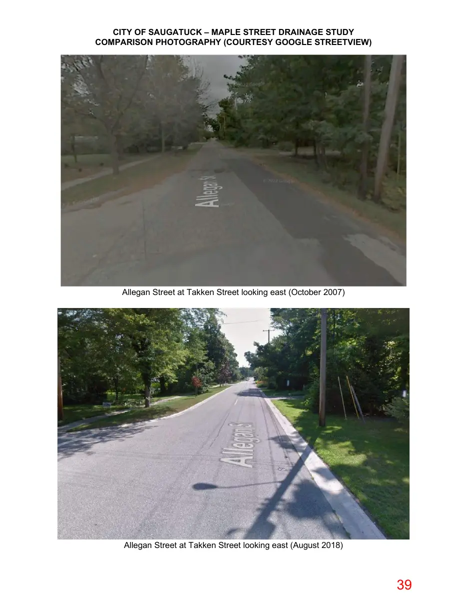
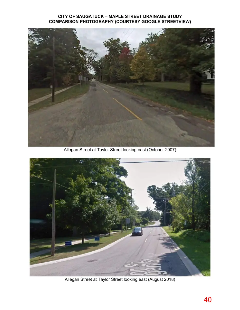
Allegan Street: In 2009, the City improved Allegan Street from Elizabeth Street to Maple Street. Prior to that project, Allegan Street was a ditched road with drive culverts and basic storm sewer. Similar to Pleasant Street, improvements included concrete curb and gutter and storm sewer replacement to bring the roadway in line with other City streets. Again, the project didn’t alter the drainage area significantly, however storm sewer is more efficient than open ditches in transporting storm water and doesn’t allow opportunity for infiltration and evaporation like an open ditch.
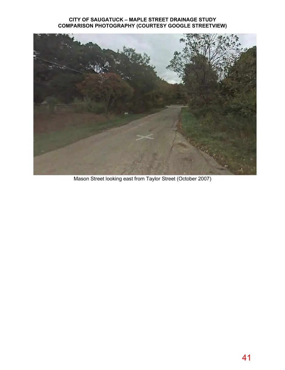
Mason Street: In 2011, the City resurfaced Mason Street with storm sewer replacement at the Takken Street and Maple Street intersections and the additional of asphalt curbing. The portion of Mason Street west of Takken has a storm sewer outlet on the northwest corner of Takken Street. The outlet at Mason & Maple carries water from Takken, Taylor and the portion of Mason Street east of Takken. As with concrete curbing, the asphalt curbing is more efficient in conveying storm water to the Maple Street intersection than ditching alone.
Maple Street: In 2014, the City enclosed the open ditch on the west side of Maple Street between Allegan Street and Mason Street. The ditch line was fairly steep, deep and overgrown and required ongoing maintenance for erosion issues, possibly in part due to the upstream improvements on Pleasant and Allegan Street discussed above. In this case, the road was not curbed, but a shallower swale was constructed above the storm sewer with a series of catch basins. This has less of an impact than curbing would have had, but the storm sewer is more efficient in transporting the water from those upstream areas.
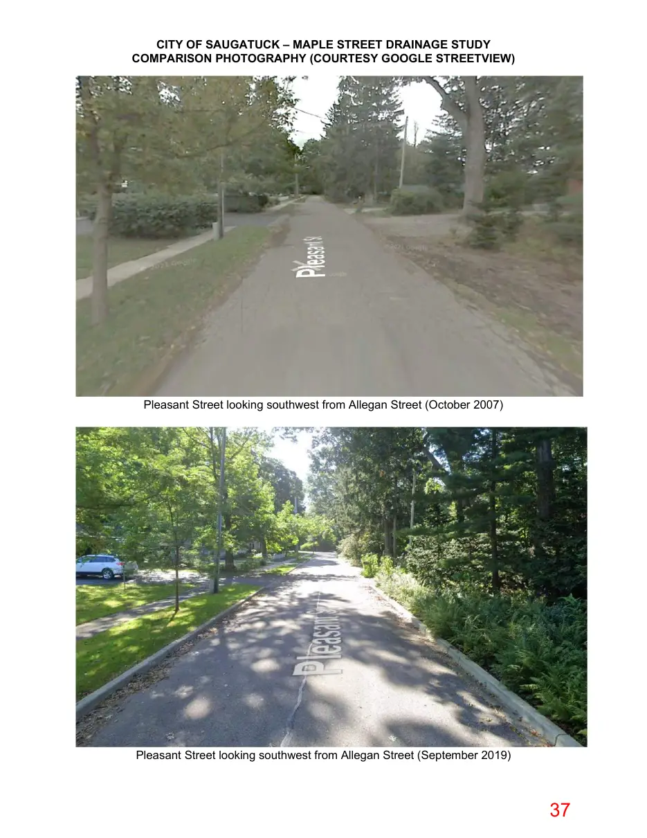
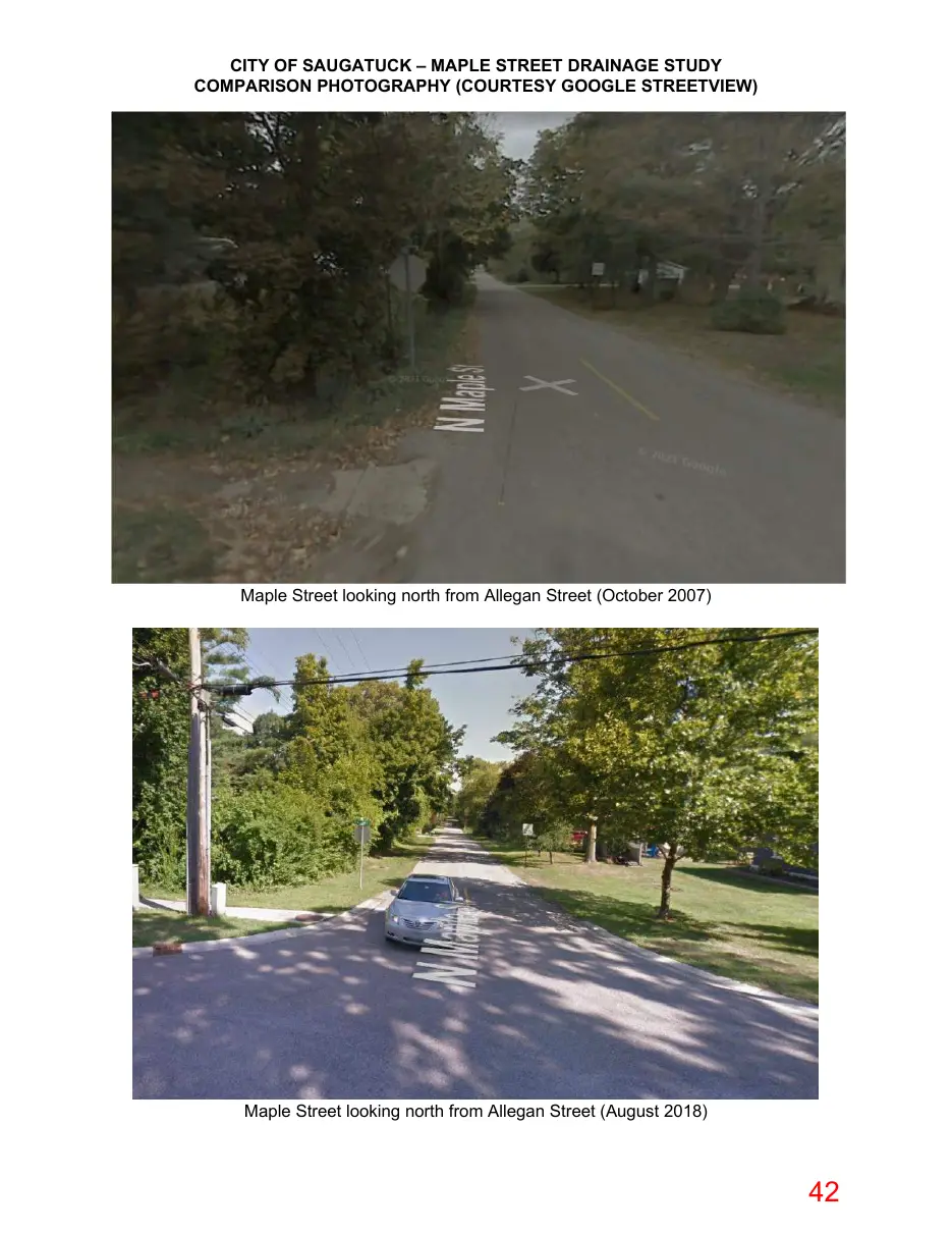
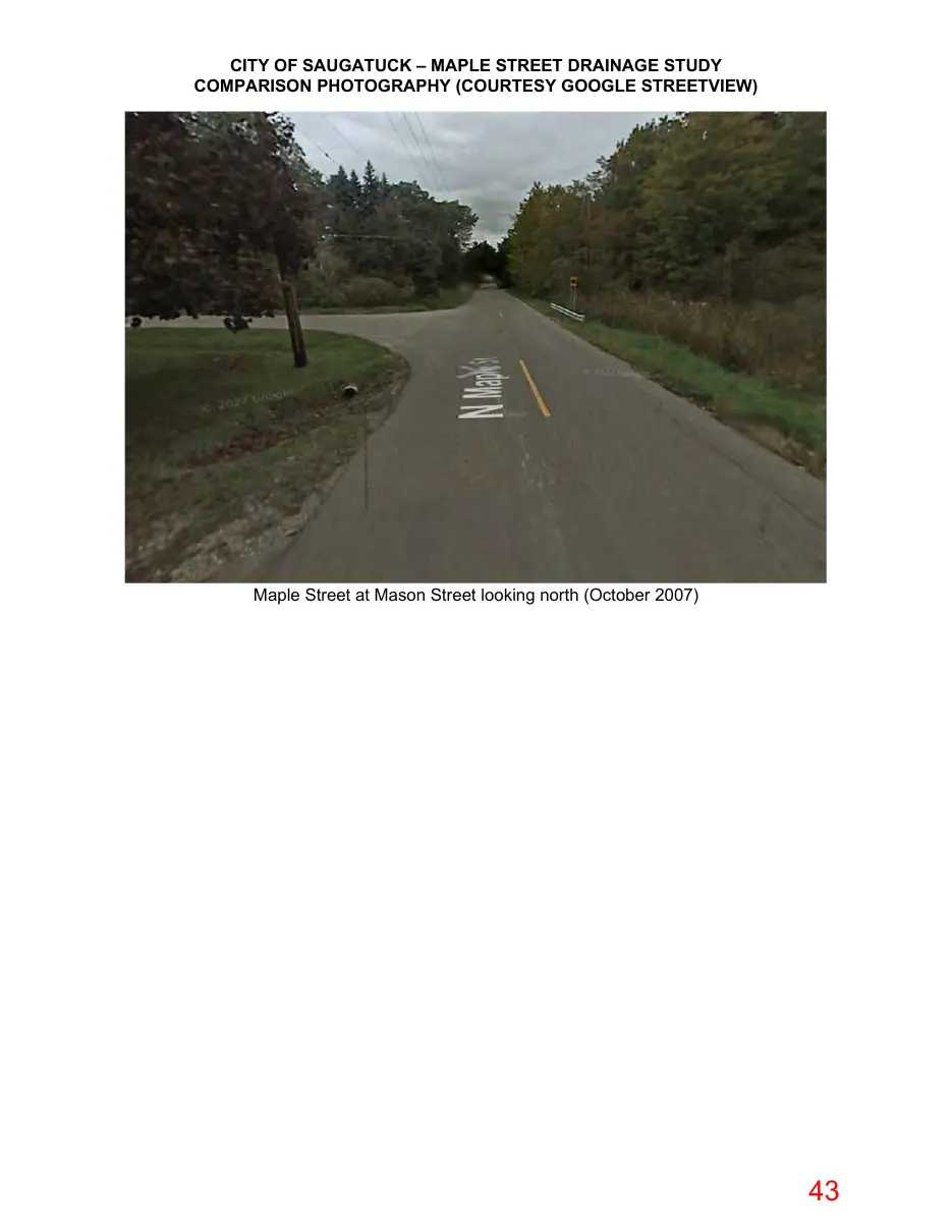
Google Street View still has areas of the October 2007 photography available – screen captures showing conditions before and after drainage and roadway improvements are attached. Mitigation Alternatives Based on our review of the areas in question and discussions with City staff, Allegan County Drain Commissioner (ACDC), Michigan Department of Environment, Great Lakes & Energy
3187-30 Maple St Report
Page 33
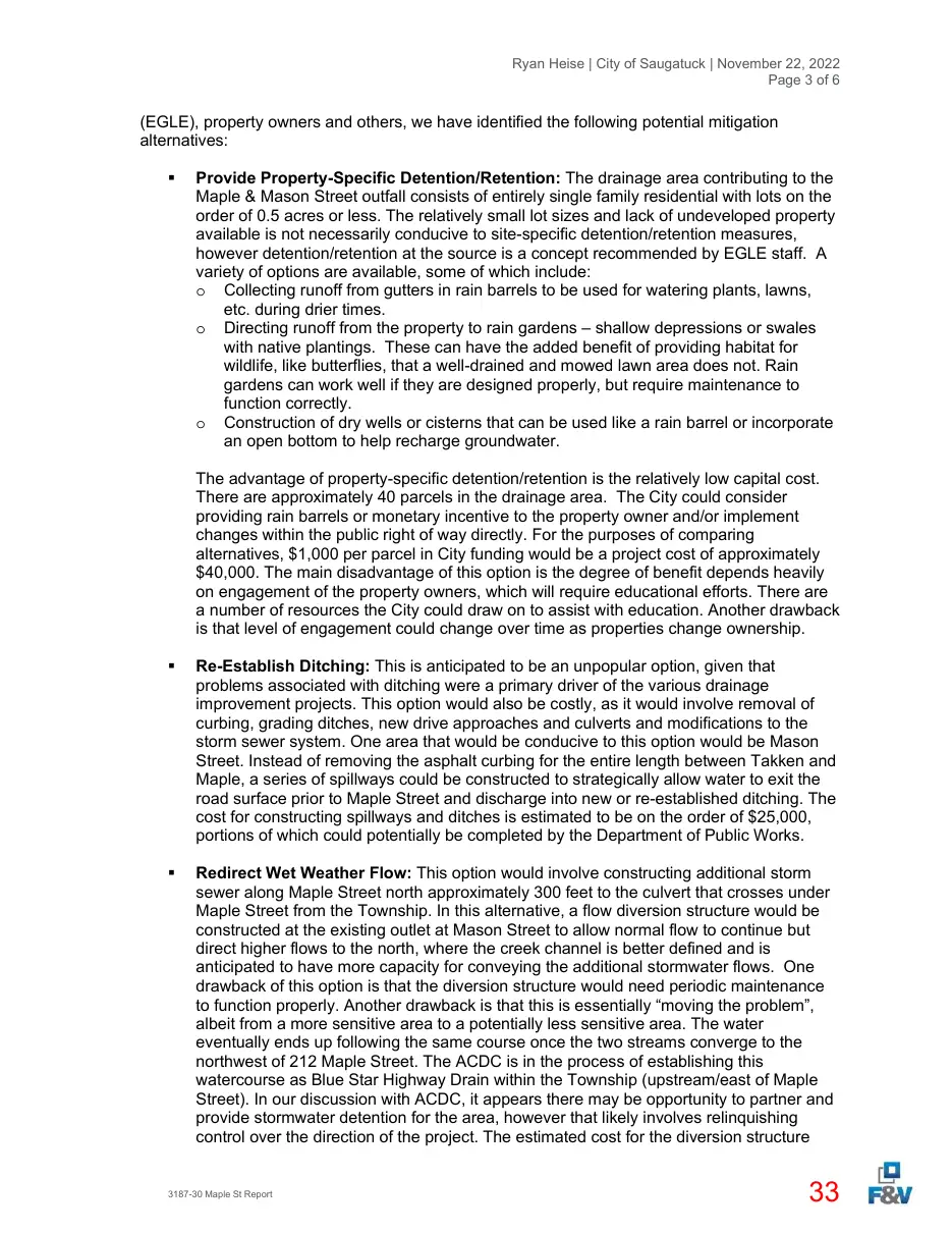
Text of page 33
Ryan Heise | City of Saugatuck | November 22, 2022 Page 3 of 6
(EGLE), property owners and others, we have identified the following potential mitigation alternatives:
Provide Property-Specific Detention/Retention: The drainage area contributing to the Maple & Mason Street outfall consists of entirely single family residential with lots on the order of 0.5 acres or less. The relatively small lot sizes and lack of undeveloped property available is not necessarily conducive to site-specific detention/retention measures, however detention/retention at the source is a concept recommended by EGLE staff. A variety of options are available, some of which include: o Collecting runoff from gutters in rain barrels to be used for watering plants, lawns, etc. during drier times. o Directing runoff from the property to rain gardens – shallow depressions or swales with native plantings. These can have the added benefit of providing habitat for wildlife, like butterflies, that a well-drained and mowed lawn area does not. Rain gardens can work well if they are designed properly, but require maintenance to function correctly. o Construction of dry wells or cisterns that can be used like a rain barrel or incorporate an open bottom to help recharge groundwater. The advantage of property-specific detention/retention is the relatively low capital cost. There are approximately 40 parcels in the drainage area. The City could consider providing rain barrels or monetary incentive to the property owner and/or implement changes within the public right of way directly. For the purposes of comparing alternatives, $1,000 per parcel in City funding would be a project cost of approximately $40,000. The main disadvantage of this option is the degree of benefit depends heavily on engagement of the property owners, which will require educational efforts. There are a number of resources the City could draw on to assist with education. Another drawback is that level of engagement could change over time as properties change ownership.
Re-Establish Ditching: This is anticipated to be an unpopular option, given that problems associated with ditching were a primary driver of the various drainage improvement projects. This option would also be costly, as it would involve removal of curbing, grading ditches, new drive approaches and culverts and modifications to the storm sewer system. One area that would be conducive to this option would be Mason Street. Instead of removing the asphalt curbing for the entire length between Takken and Maple, a series of spillways could be constructed to strategically allow water to exit the road surface prior to Maple Street and discharge into new or re-established ditching. The cost for constructing spillways and ditches is estimated to be on the order of $25,000, portions of which could potentially be completed by the Department of Public Works.
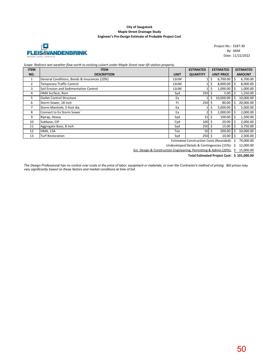
Redirect Wet Weather Flow: This option would involve constructing additional storm sewer along Maple Street north approximately 300 feet to the culvert that crosses under Maple Street from the Township. In this alternative, a flow diversion structure would be constructed at the existing outlet at Mason Street to allow normal flow to continue but direct higher flows to the north, where the creek channel is better defined and is anticipated to have more capacity for conveying the additional stormwater flows. One drawback of this option is that the diversion structure would need periodic maintenance to function properly. Another drawback is that this is essentially “moving the problem”, albeit from a more sensitive area to a potentially less sensitive area. The water eventually ends up following the same course once the two streams converge to the northwest of 212 Maple Street. The ACDC is in the process of establishing this watercourse as Blue Star Highway Drain within the Township (upstream/east of Maple Street). In our discussion with ACDC, it appears there may be opportunity to partner and provide stormwater detention for the area, however that likely involves relinquishing control over the direction of the project. The estimated cost for the diversion structure
3187-30 Maple St Report
Page 34
Text of page 34
Ryan Heise | City of Saugatuck | November 22, 2022 Page 4 of 6
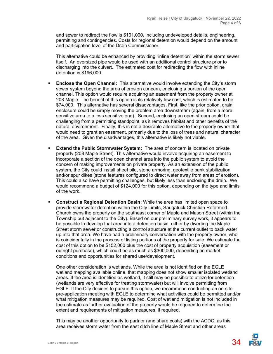
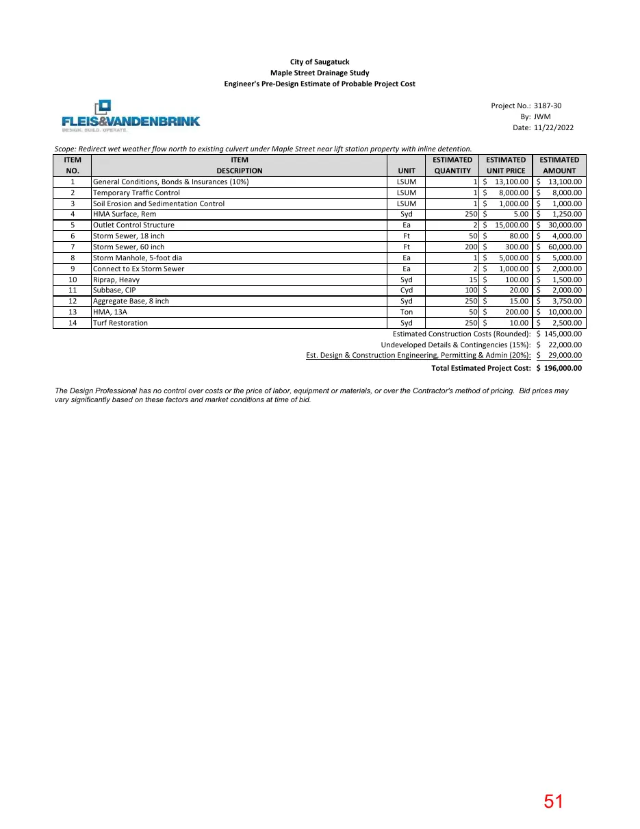
and sewer to redirect the flow is $101,000, including undeveloped details, engineering, permitting and contingencies. Costs for regional detention would depend on the amount and participation level of the Drain Commissioner. This alternative could be enhanced by providing “inline detention” within the storm sewer itself. An oversized pipe would be used with an additional control structure prior to discharging into the culvert. The estimated cost for redirecting the flow with inline detention is $196,000.
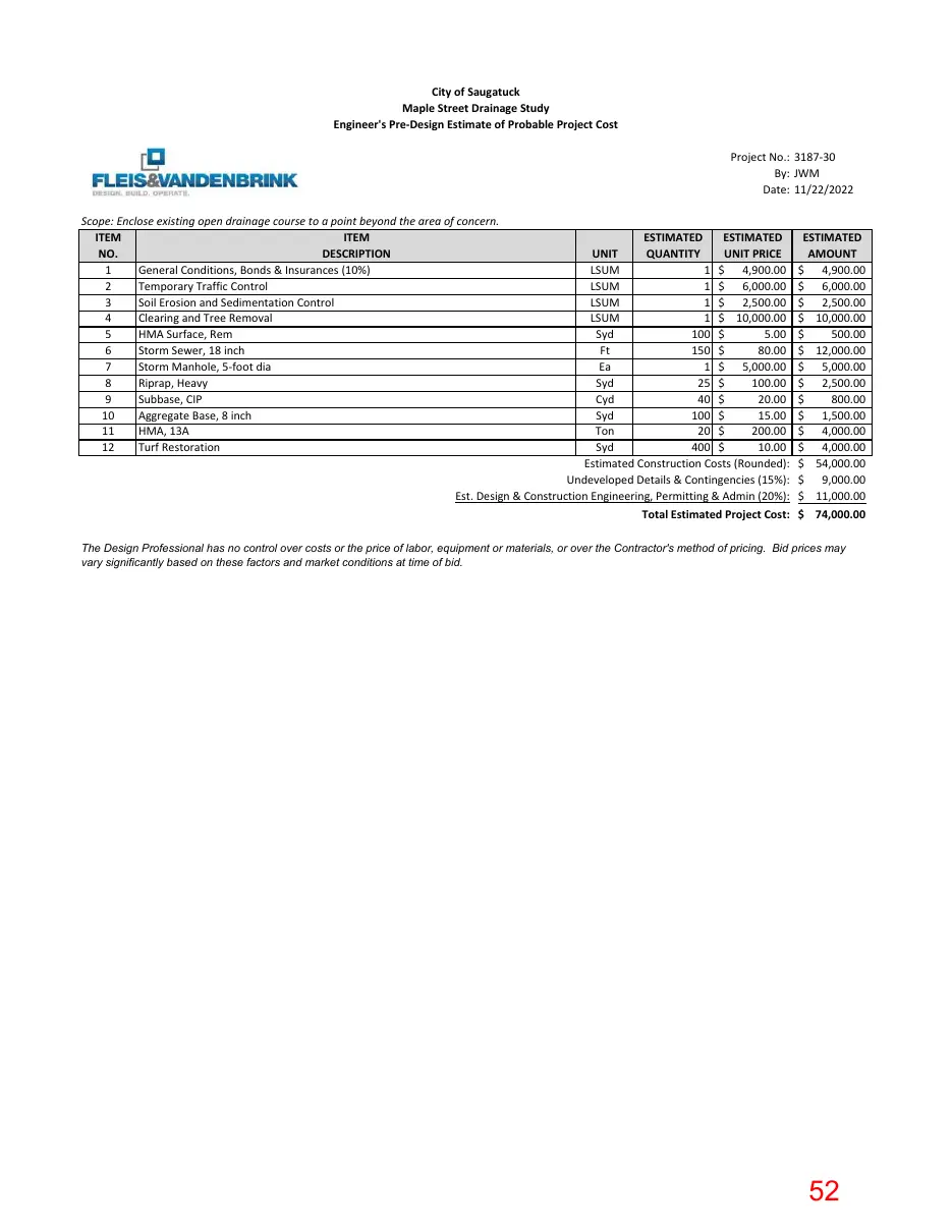
Enclose the Open Channel: This alternative would involve extending the City’s storm sewer system beyond the area of erosion concern, enclosing a portion of the open channel. This option would require acquiring an easement from the property owner at 208 Maple. The benefit of this option is its relatively low cost, which is estimated to be $74,000. This alternative has several disadvantages. First, like the prior option, drain enclosure could be simply moving the problem area downstream (again, from a more sensitive area to a less sensitive one). Second, enclosing an open stream could be challenging from a permitting standpoint, as it removes habitat and other benefits of the natural environment. Finally, this is not a desirable alternative to the property owner that would need to grant an easement, primarily due to the loss of trees and natural character of the area. Given the disadvantages, this alternative is likely not viable.
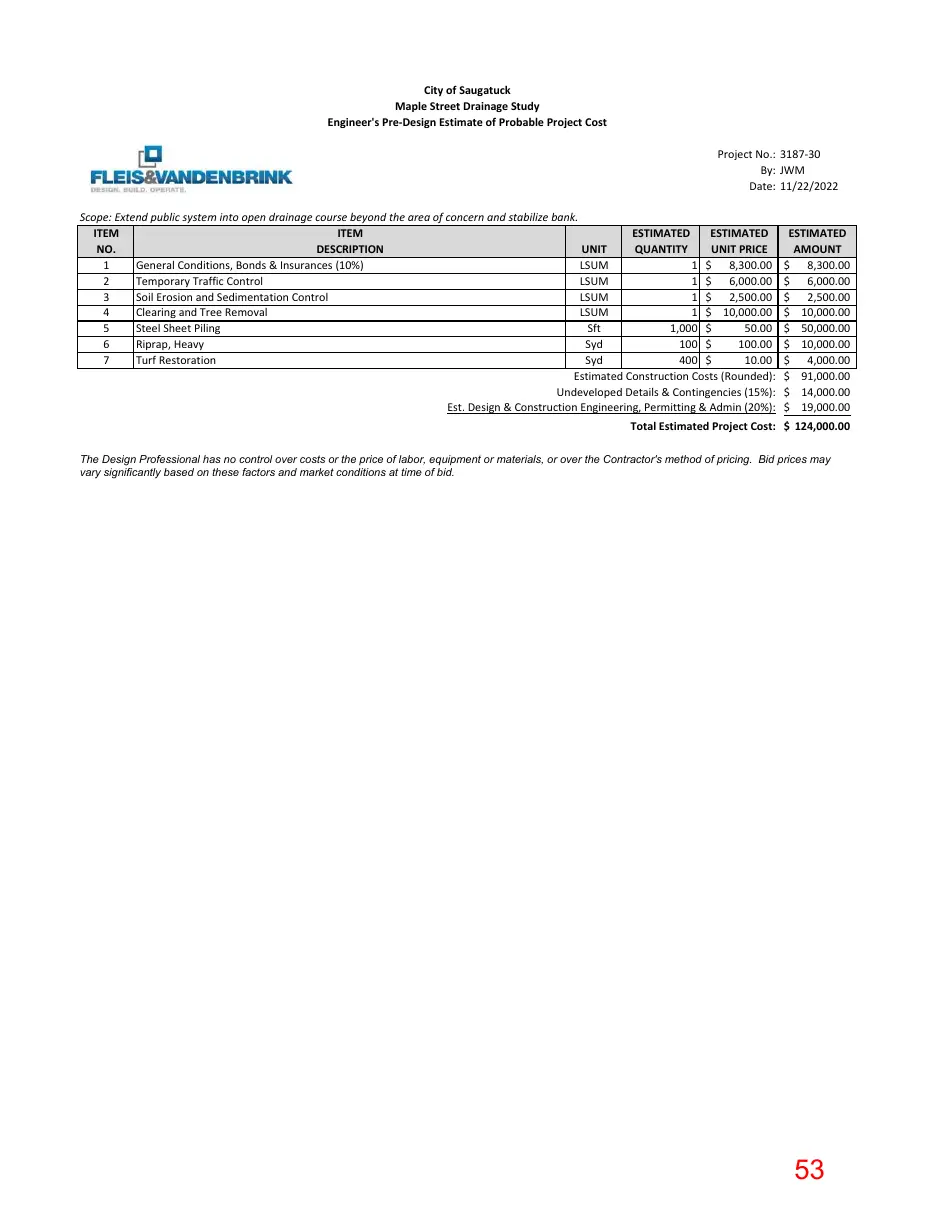
Extend the Public Stormwater System: The area of concern is located on private property (208 Maple Street). This alternative would involve acquiring an easement to incorporate a section of the open channel area into the public system to avoid the concern of making improvements on private property. As an extension of the public system, the City could install sheet pile, stone armoring, geotextile bank stabilization and/or spur dikes (stone features configured to direct water away from areas of erosion). This could also have permitting challenges, but likely less than enclosing the drain. We would recommend a budget of $124,000 for this option, depending on the type and limits of the work.
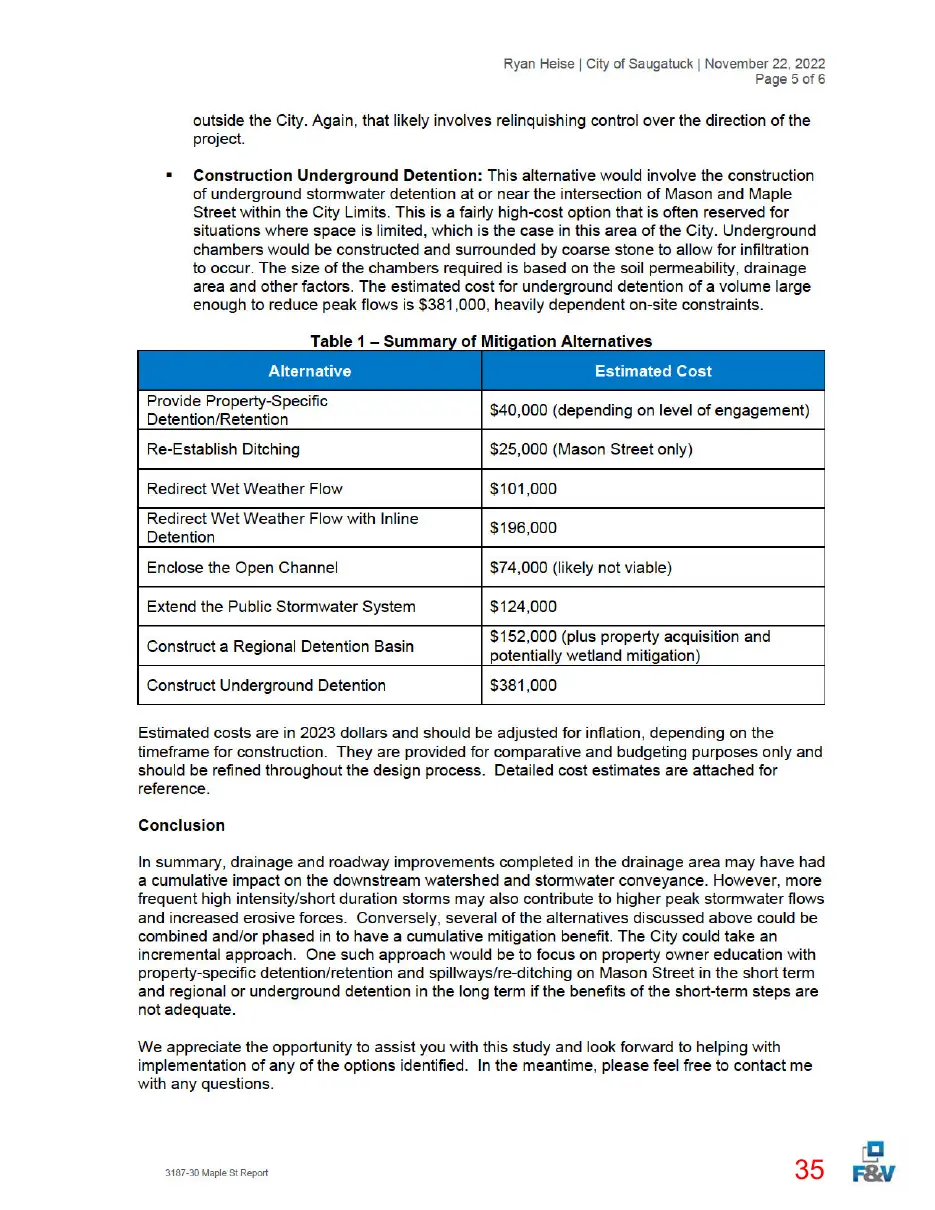
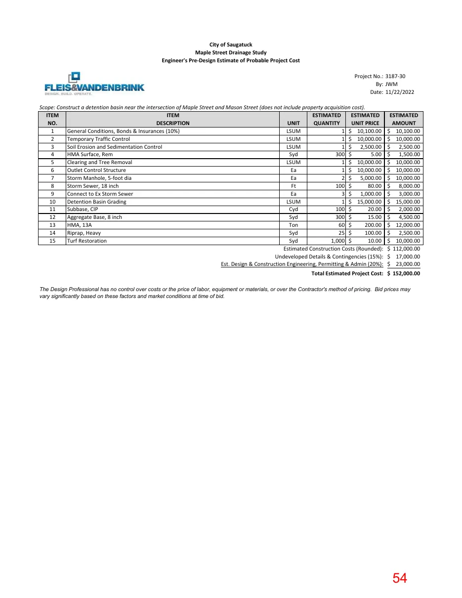
Construct a Regional Detention Basin: While the area has limited open space to provide stormwater detention within the City Limits, Saugatuck Christian Reformed Church owns the property on the southeast corner of Maple and Mason Street (within the Township but adjacent to the City). Based on our preliminary survey work, it appears to be possible to develop that area into a detention basin, either by diverting the Maple Street storm sewer or constructing a control structure at the current outlet to back water up into that area. We have had a preliminary conversation with the property owner, who is coincidentally in the process of listing portions of the property for sale. We estimate the cost of this option to be $152,000 plus the cost of property acquisition (easement or outright purchase), which could be as much as $300,000, depending on market conditions and opportunities for shared use/development. One other consideration is wetlands. While the area is not identified on the EGLE wetland mapping available online, that mapping does not show smaller isolated wetland areas. If the area is identified as wetland, it still may be possible to utilize for detention (wetlands are very effective for treating stormwater) but will involve permitting from EGLE. If the City decides to pursue this option, we recommend conducting an on-site pre-application meeting with EGLE to determine what activities could be permitted and/or what mitigation measures may be required. Cost of wetland mitigation is not included in the estimate as further evaluation of the property would be required to determine the extent and requirements of mitigation measures, if required. This may be another opportunity to partner (and share costs) with the ACDC, as this area receives storm water from the east ditch line of Maple Street and other areas
3187-30 Maple St Report
Page 35
This page is a scanned image with no text layer. The PDF of these pages has it at full resolution.
Page 36
Text of page 36
Ryan Heise | City of Saugatuck | November 22, 2022 Page 6 of 6
Sincerely, FLEIS & VANDENBRINK
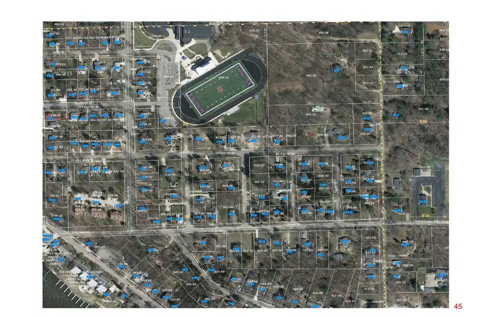
Jonathan W. Moxey, P.E. Project Manager Enclosures Comparison Photography ACDC Watersheds Map Parcel Map of Study Area Approximate Tributary Area Map Schematics of Mitigation Measures Cost Estimates
3187-30 Maple St Report
Page 37
Text of page 37
CITY OF SAUGATUCK – MAPLE STREET DRAINAGE STUDY COMPARISON PHOTOGRAPHY (COURTESY GOOGLE STREETVIEW)
Pleasant Street looking southwest from Allegan Street (October 2007)
Pleasant Street looking southwest from Allegan Street (September 2019)
Page 38
Text of page 38
CITY OF SAUGATUCK – MAPLE STREET DRAINAGE STUDY COMPARISON PHOTOGRAPHY (COURTESY GOOGLE STREETVIEW)
Pleasant Street looking northwest toward Allegan Street (October 2007)
Pleasant Street looking northwest toward Allegan Street (September 2019)
Page 39
Text of page 39
CITY OF SAUGATUCK – MAPLE STREET DRAINAGE STUDY COMPARISON PHOTOGRAPHY (COURTESY GOOGLE STREETVIEW)
Allegan Street at Takken Street looking east (October 2007)
Allegan Street at Takken Street looking east (August 2018)
Page 40
Text of page 40
CITY OF SAUGATUCK – MAPLE STREET DRAINAGE STUDY COMPARISON PHOTOGRAPHY (COURTESY GOOGLE STREETVIEW)
Allegan Street at Taylor Street looking east (October 2007)
Allegan Street at Taylor Street looking east (August 2018)
Page 41
Text of page 41
CITY OF SAUGATUCK – MAPLE STREET DRAINAGE STUDY COMPARISON PHOTOGRAPHY (COURTESY GOOGLE STREETVIEW)
Mason Street looking east from Taylor Street (October 2007)
Page 42
Text of page 42
CITY OF SAUGATUCK – MAPLE STREET DRAINAGE STUDY COMPARISON PHOTOGRAPHY (COURTESY GOOGLE STREETVIEW)
Maple Street looking north from Allegan Street (October 2007)
Maple Street looking north from Allegan Street (August 2018)
Page 43
Text of page 43
CITY OF SAUGATUCK – MAPLE STREET DRAINAGE STUDY COMPARISON PHOTOGRAPHY (COURTESY GOOGLE STREETVIEW)
Maple Street at Mason Street looking north (October 2007)
Page 44
This page is a scanned image with no text layer. The PDF of these pages has it at full resolution.
Page 45
This page is a scanned image with no text layer. The PDF of these pages has it at full resolution.
Page 46
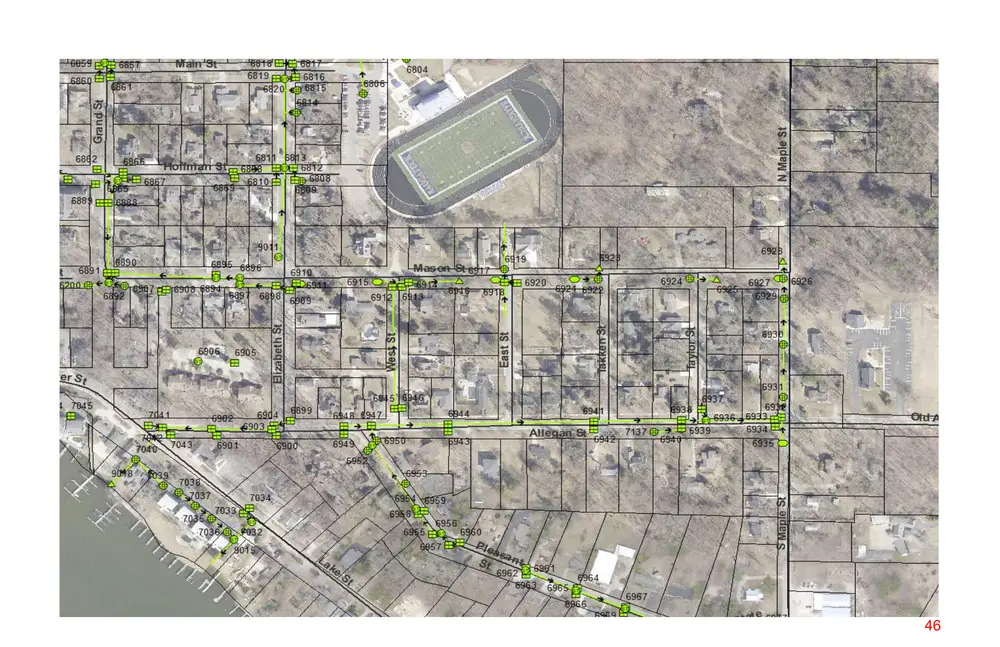
This page is a scanned image with no text layer. The PDF of these pages has it at full resolution.
Page 47
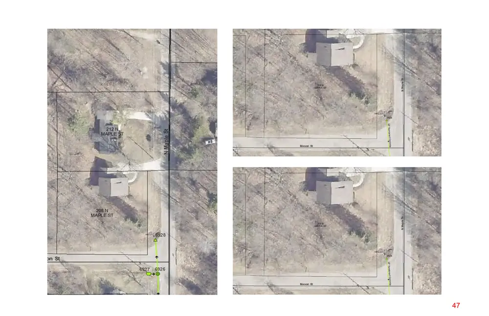
This page is a scanned image with no text layer. The PDF of these pages has it at full resolution.
Page 48
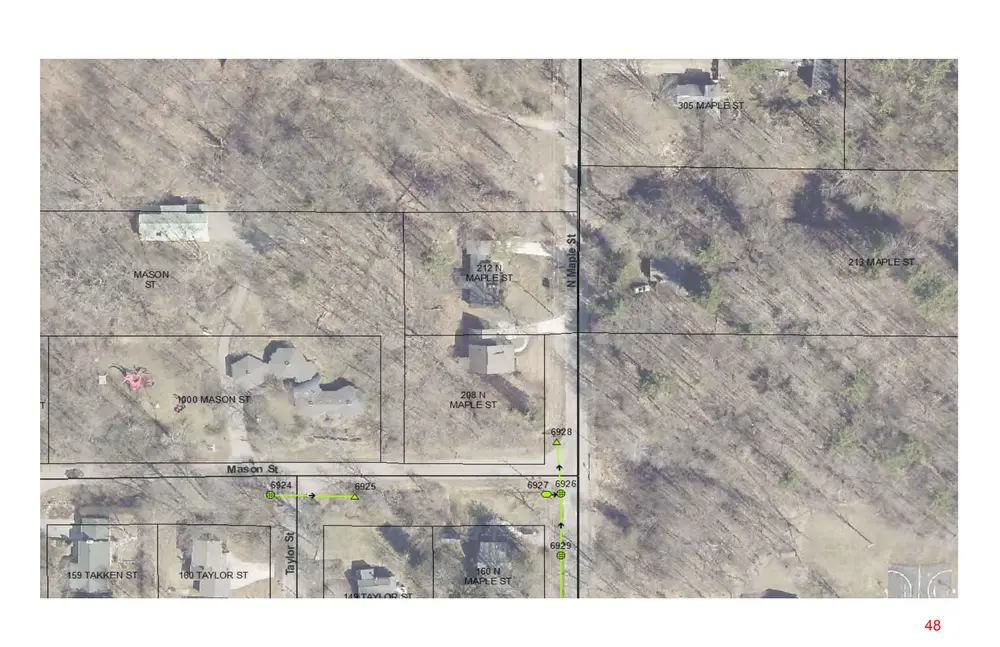
This page is a scanned image with no text layer. The PDF of these pages has it at full resolution.
Page 49
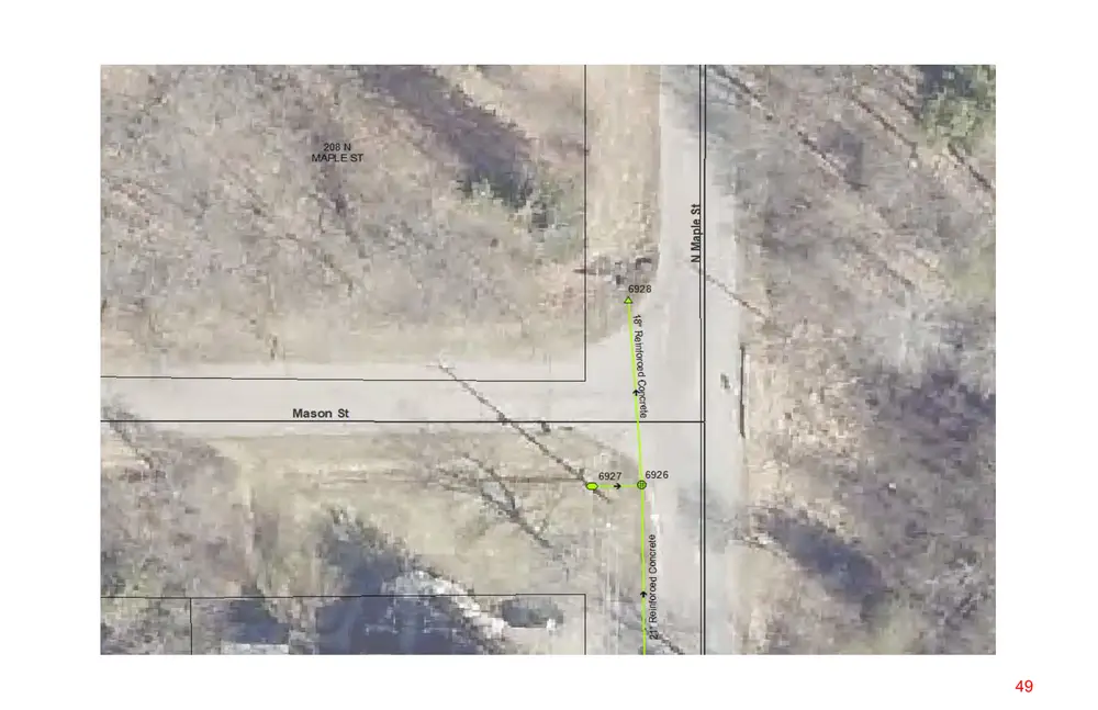
This page is a scanned image with no text layer. The PDF of these pages has it at full resolution.
Page 50
Text of page 50
City of Saugatuck Maple Street Drainage Study Engineer's Pre-Design Estimate of Probable Project Cost Project No.: 3187-30 By: JWM Date: 11/22/2022 Scope: Redirect wet weather flow north to existing culvert under Maple Street near lift station property. ITEM ITEM ESTIMATED ESTIMATED ESTIMATED NO. DESCRIPTION UNIT QUANTITY UNIT PRICE AMOUNT 1 General Conditions, Bonds & Insurances (10%) LSUM 1 $ 6,700.00 $ 6,700.00 2 Temporary Traffic Control LSUM 1 $ 8,000.00 $ 8,000.00 3 Soil Erosion and Sedimentation Control LSUM 1 $ 1,000.00 $ 1,000.00 4 HMA Surface, Rem Syd 250 $ 5.00 $ 1,250.00 5 Outlet Control Structure Ea 1 $ 10,000.00 $ 10,000.00 6 Storm Sewer, 18 inch Ft 250 $ 80.00 $ 20,000.00 7 Storm Manhole, 5-foot dia Ea 1 $ 5,000.00 $ 5,000.00 8 Connect to Ex Storm Sewer Ea 2 $ 1,000.00 $ 2,000.00 9 Riprap, Heavy Syd 15 $ 100.00 $ 1,500.00 10 Subbase, CIP Cyd 100 $ 20.00 $ 2,000.00 11 Aggregate Base, 8 inch Syd 250 $ 15.00 $ 3,750.00 12 HMA, 13A Ton 50 $ 200.00 $ 10,000.00 13 Turf Restoration Syd 250 $ 10.00 $ 2,500.00 Estimated Construction Costs (Rounded): $ 74,000.00 Undeveloped Details & Contingencies (15%): $ 12,000.00 Est. Design & Construction Engineering, Permitting & Admin (20%): $ 15,000.00 Total Estimated Project Cost: $ 101,000.00 The Design Professional has no control over costs or the price of labor, equipment or materials, or over the Contractor's method of pricing. Bid prices may vary significantly based on these factors and market conditions at time of bid.
Page 51
Text of page 51
City of Saugatuck Maple Street Drainage Study Engineer's Pre-Design Estimate of Probable Project Cost Project No.: 3187-30 By: JWM Date: 11/22/2022 Scope: Redirect wet weather flow north to existing culvert under Maple Street near lift station property with inline detention. ITEM ITEM ESTIMATED ESTIMATED ESTIMATED NO. DESCRIPTION UNIT QUANTITY UNIT PRICE AMOUNT 1 General Conditions, Bonds & Insurances (10%) LSUM 1 $ 13,100.00 $ 13,100.00 2 Temporary Traffic Control LSUM 1 $ 8,000.00 $ 8,000.00 3 Soil Erosion and Sedimentation Control LSUM 1 $ 1,000.00 $ 1,000.00 4 HMA Surface, Rem Syd 250 $ 5.00 $ 1,250.00 5 Outlet Control Structure Ea 2 $ 15,000.00 $ 30,000.00 6 Storm Sewer, 18 inch Ft 50 $ 80.00 $ 4,000.00 7 Storm Sewer, 60 inch Ft 200 $ 300.00 $ 60,000.00 8 Storm Manhole, 5-foot dia Ea 1 $ 5,000.00 $ 5,000.00 9 Connect to Ex Storm Sewer Ea 2 $ 1,000.00 $ 2,000.00 10 Riprap, Heavy Syd 15 $ 100.00 $ 1,500.00 11 Subbase, CIP Cyd 100 $ 20.00 $ 2,000.00 12 Aggregate Base, 8 inch Syd 250 $ 15.00 $ 3,750.00 13 HMA, 13A Ton 50 $ 200.00 $ 10,000.00 14 Turf Restoration Syd 250 $ 10.00 $ 2,500.00 Estimated Construction Costs (Rounded): $ 145,000.00 Undeveloped Details & Contingencies (15%): $ 22,000.00 Est. Design & Construction Engineering, Permitting & Admin (20%): $ 29,000.00 Total Estimated Project Cost: $ 196,000.00 The Design Professional has no control over costs or the price of labor, equipment or materials, or over the Contractor's method of pricing. Bid prices may vary significantly based on these factors and market conditions at time of bid.
Page 52
Text of page 52
City of Saugatuck Maple Street Drainage Study Engineer's Pre-Design Estimate of Probable Project Cost Project No.: 3187-30 By: JWM Date: 11/22/2022 Scope: Enclose existing open drainage course to a point beyond the area of concern. ITEM ITEM NO. DESCRIPTION 1 General Conditions, Bonds & Insurances (10%) 2 Temporary Traffic Control 3 Soil Erosion and Sedimentation Control 4 Clearing and Tree Removal 5 HMA Surface, Rem 6 Storm Sewer, 18 inch 7 Storm Manhole, 5-foot dia 8 Riprap, Heavy 9 Subbase, CIP 10 Aggregate Base, 8 inch 11 HMA, 13A 12 Turf Restoration
ESTIMATED ESTIMATED ESTIMATED UNIT QUANTITY UNIT PRICE AMOUNT LSUM 1 $ 4,900.00 $ 4,900.00 LSUM 1 $ 6,000.00 $ 6,000.00 LSUM 1 $ 2,500.00 $ 2,500.00 LSUM 1 $ 10,000.00 $ 10,000.00 Syd 100 $ 5.00 $ 500.00 Ft 150 $ 80.00 $ 12,000.00 Ea 1 $ 5,000.00 $ 5,000.00 Syd 25 $ 100.00 $ 2,500.00 Cyd 40 $ 20.00 $ 800.00 Syd 100 $ 15.00 $ 1,500.00 Ton 20 $ 200.00 $ 4,000.00 Syd 400 $ 10.00 $ 4,000.00 Estimated Construction Costs (Rounded): $ 54,000.00 Undeveloped Details & Contingencies (15%): $ 9,000.00 Est. Design & Construction Engineering, Permitting & Admin (20%): $ 11,000.00 Total Estimated Project Cost: $ 74,000.00
The Design Professional has no control over costs or the price of labor, equipment or materials, or over the Contractor's method of pricing. Bid prices may vary significantly based on these factors and market conditions at time of bid.
Page 53
Text of page 53
City of Saugatuck Maple Street Drainage Study Engineer's Pre-Design Estimate of Probable Project Cost Project No.: 3187-30 By: JWM Date: 11/22/2022 Scope: Extend public system into open drainage course beyond the area of concern and stabilize bank. ITEM ITEM ESTIMATED ESTIMATED ESTIMATED NO. DESCRIPTION UNIT QUANTITY UNIT PRICE AMOUNT 1 General Conditions, Bonds & Insurances (10%) LSUM 1 $ 8,300.00 $ 8,300.00 2 Temporary Traffic Control LSUM 1 $ 6,000.00 $ 6,000.00 3 Soil Erosion and Sedimentation Control LSUM 1 $ 2,500.00 $ 2,500.00 4 Clearing and Tree Removal LSUM 1 $ 10,000.00 $ 10,000.00 5 Steel Sheet Piling Sft 1,000 $ 50.00 $ 50,000.00 6 Riprap, Heavy Syd 100 $ 100.00 $ 10,000.00 7 Turf Restoration Syd 400 $ 10.00 $ 4,000.00 Estimated Construction Costs (Rounded): $ 91,000.00 Undeveloped Details & Contingencies (15%): $ 14,000.00 Est. Design & Construction Engineering, Permitting & Admin (20%): $ 19,000.00 Total Estimated Project Cost: $ 124,000.00 The Design Professional has no control over costs or the price of labor, equipment or materials, or over the Contractor's method of pricing. Bid prices may vary significantly based on these factors and market conditions at time of bid.
Page 54
Text of page 54
City of Saugatuck Maple Street Drainage Study Engineer's Pre-Design Estimate of Probable Project Cost Project No.: 3187-30 By: JWM Date: 11/22/2022 Scope: Construct a detention basin near the intersection of Maple Street and Mason Street (does not include property acquisition cost). ITEM ITEM ESTIMATED ESTIMATED ESTIMATED NO. DESCRIPTION UNIT QUANTITY UNIT PRICE AMOUNT 1 General Conditions, Bonds & Insurances (10%) LSUM 1 $ 10,100.00 $ 10,100.00 2 Temporary Traffic Control LSUM 1 $ 10,000.00 $ 10,000.00 3 Soil Erosion and Sedimentation Control LSUM 1 $ 2,500.00 $ 2,500.00 4 HMA Surface, Rem Syd 300 $ 5.00 $ 1,500.00 5 Clearing and Tree Removal LSUM 1 $ 10,000.00 $ 10,000.00 6 Outlet Control Structure Ea 1 $ 10,000.00 $ 10,000.00 7 Storm Manhole, 5-foot dia Ea 2 $ 5,000.00 $ 10,000.00 8 Storm Sewer, 18 inch Ft 100 $ 80.00 $ 8,000.00 9 Connect to Ex Storm Sewer Ea 3 $ 1,000.00 $ 3,000.00 10 Detention Basin Grading LSUM 1 $ 15,000.00 $ 15,000.00 11 Subbase, CIP Cyd 100 $ 20.00 $ 2,000.00 12 Aggregate Base, 8 inch Syd 300 $ 15.00 $ 4,500.00 13 HMA, 13A Ton 60 $ 200.00 $ 12,000.00 14 Riprap, Heavy Syd 25 $ 100.00 $ 2,500.00 15 Turf Restoration Syd 1,000 $ 10.00 $ 10,000.00 Estimated Construction Costs (Rounded): $ 112,000.00 Undeveloped Details & Contingencies (15%): $ 17,000.00 Est. Design & Construction Engineering, Permitting & Admin (20%): $ 23,000.00 Total Estimated Project Cost: $ 152,000.00 The Design Professional has no control over costs or the price of labor, equipment or materials, or over the Contractor's method of pricing. Bid prices may vary significantly based on these factors and market conditions at time of bid.
Page 55
Text of page 55
City of Saugatuck Maple Street Drainage Study Engineer's Pre-Design Estimate of Probable Project Cost Project No.: 3187-30 By: JWM Date: 11/22/2022 Scope: Construct underground detention near the intersection of Maple Street and Mason Street (within the right of way). ITEM ITEM ESTIMATED ESTIMATED ESTIMATED NO. DESCRIPTION UNIT QUANTITY UNIT PRICE AMOUNT 1 General Conditions, Bonds & Insurances (10%) LSUM 1 $ 25,500.00 $ 25,500.00 2 Temporary Traffic Control LSUM 1 $ 10,000.00 $ 10,000.00 3 Soil Erosion and Sedimentation Control LSUM 1 $ 2,500.00 $ 2,500.00 4 HMA Surface, Rem Syd 500 $ 5.00 $ 2,500.00 5 Outlet Control Structure Ea 1 $ 10,000.00 $ 10,000.00 6 Underground Detention Cft 12,000 $ 15.00 $ 180,000.00 7 Storm Manhole, 5-foot dia Ea 2 $ 5,000.00 $ 10,000.00 8 Storm Sewer, 18 inch Ft 20 $ 80.00 $ 1,600.00 9 Connect to Ex Storm Sewer Ea 2 $ 1,000.00 $ 2,000.00 10 Subbase, CIP Cyd 200 $ 20.00 $ 4,000.00 11 Aggregate Base, 8 inch Syd 500 $ 15.00 $ 7,500.00 12 HMA, 13A Ton 100 $ 200.00 $ 20,000.00 13 Riprap, Heavy Syd 15 $ 100.00 $ 1,500.00 14 Turf Restoration Syd 300 $ 10.00 $ 3,000.00 Estimated Construction Costs (Rounded): $ 281,000.00 Undeveloped Details & Contingencies (15%): $ 43,000.00 Est. Design & Construction Engineering, Permitting & Admin (20%): $ 57,000.00 Total Estimated Project Cost: $ 381,000.00 The Design Professional has no control over costs or the price of labor, equipment or materials, or over the Contractor's method of pricing. Bid prices may vary significantly based on these factors and market conditions at time of bid.
Page 56
This page is a scanned image with no text layer. The PDF of these pages has it at full resolution.
Page 57
This page is a scanned image with no text layer. The PDF of these pages has it at full resolution.
Page 58
This page is a scanned image with no text layer. The PDF of these pages has it at full resolution.
Page 59
This page is a scanned image with no text layer. The PDF of these pages has it at full resolution.
Page 60
This page is a scanned image with no text layer. The PDF of these pages has it at full resolution.
Page 61
This page is a scanned image with no text layer. The PDF of these pages has it at full resolution.
Page 62
This page is a scanned image with no text layer. The PDF of these pages has it at full resolution.
Page 63
This page is a scanned image with no text layer. The PDF of these pages has it at full resolution.
Page 64
This page is a scanned image with no text layer. The PDF of these pages has it at full resolution.
Page 65
This page is a scanned image with no text layer. The PDF of these pages has it at full resolution.
Page 66
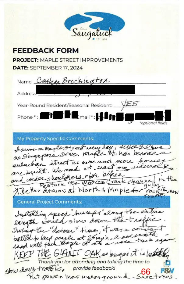
This page is a scanned image with no text layer. The PDF of these pages has it at full resolution.
Page 67
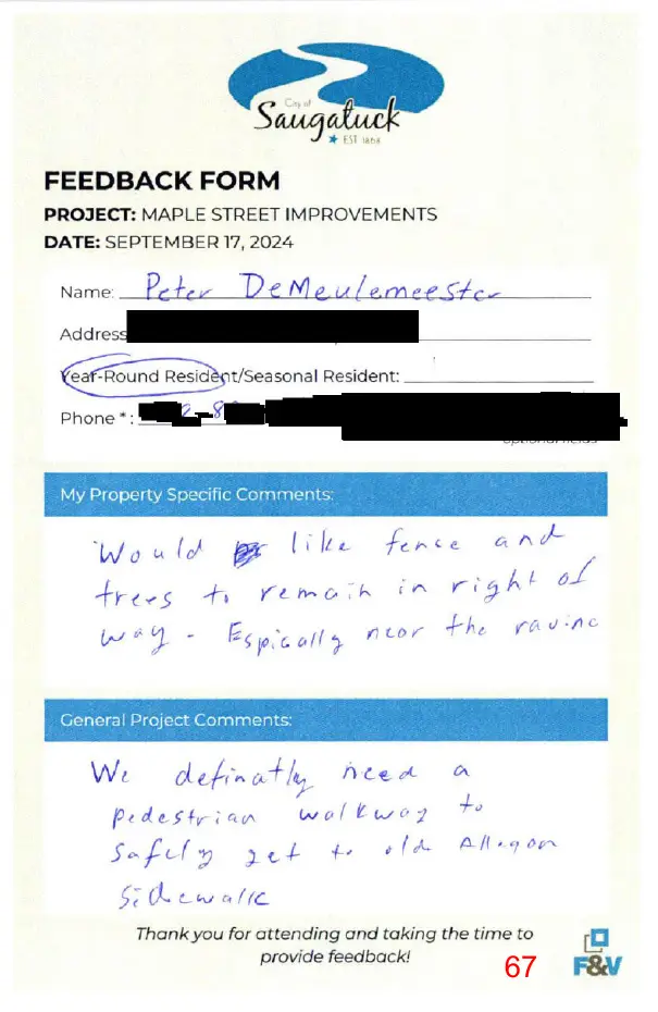
This page is a scanned image with no text layer. The PDF of these pages has it at full resolution.
Page 68
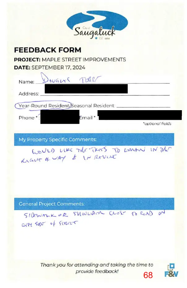
This page is a scanned image with no text layer. The PDF of these pages has it at full resolution.
Page 69
This page is a scanned image with no text layer. The PDF of these pages has it at full resolution.
Page 70
This page is a scanned image with no text layer. The PDF of these pages has it at full resolution.
Page 71
This page is a scanned image with no text layer. The PDF of these pages has it at full resolution.
Page 72
This page is a scanned image with no text layer. The PDF of these pages has it at full resolution.
Page 73
This page is a scanned image with no text layer. The PDF of these pages has it at full resolution.
Page 74
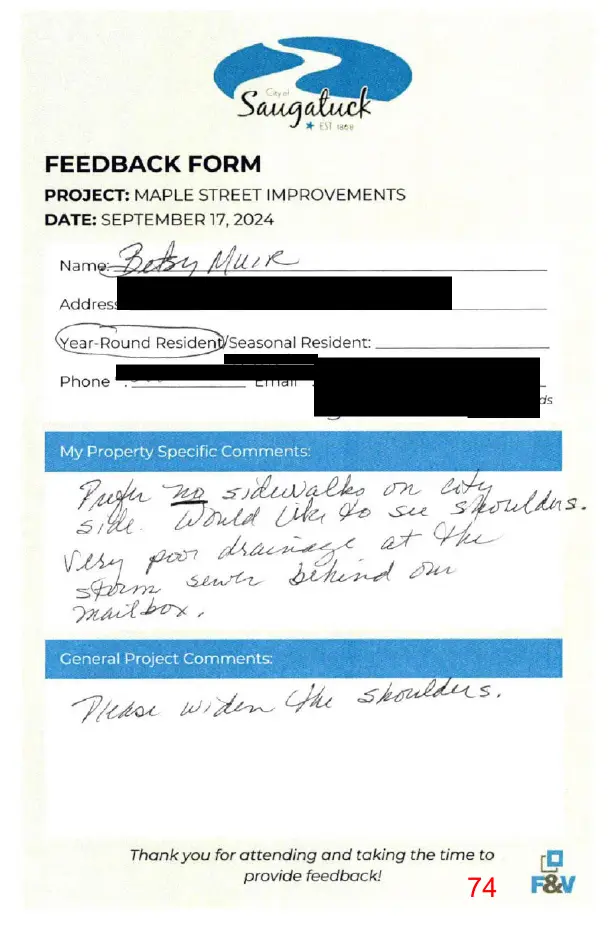
This page is a scanned image with no text layer. The PDF of these pages has it at full resolution.
Page 75
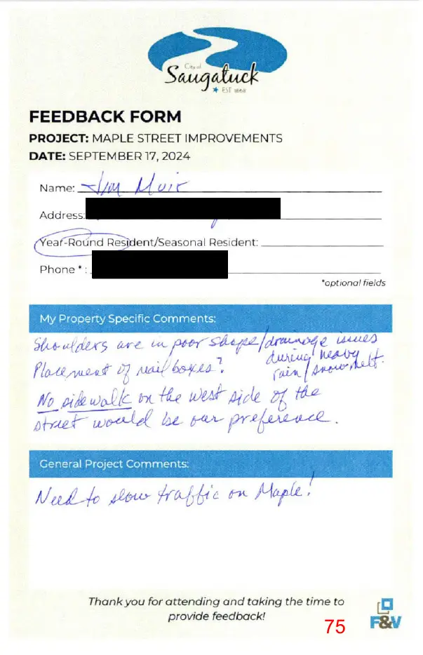
This page is a scanned image with no text layer. The PDF of these pages has it at full resolution.
Page 76
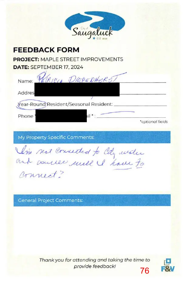
This page is a scanned image with no text layer. The PDF of these pages has it at full resolution.
Page 77
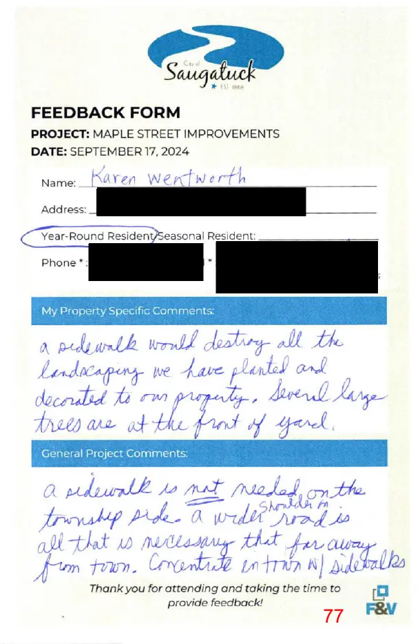
This page is a scanned image with no text layer. The PDF of these pages has it at full resolution.
Page 78
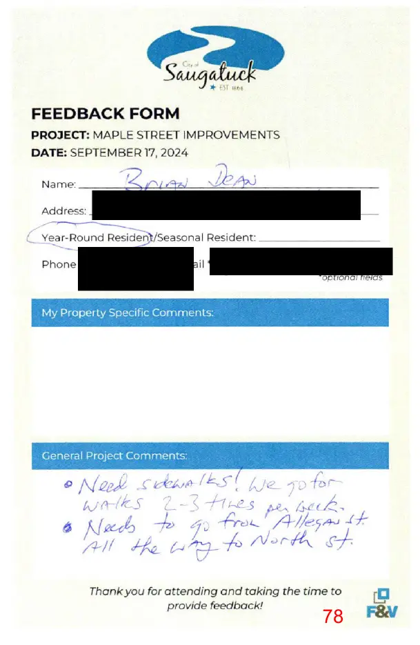
This page is a scanned image with no text layer. The PDF of these pages has it at full resolution.
Page 79
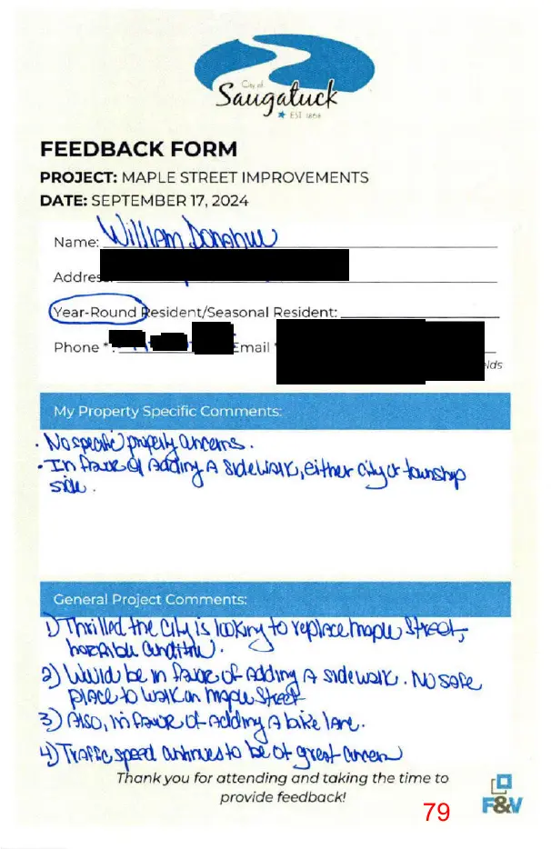
This page is a scanned image with no text layer. The PDF of these pages has it at full resolution.
Page 80
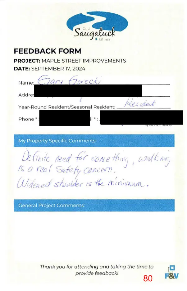
This page is a scanned image with no text layer. The PDF of these pages has it at full resolution.
Page 81
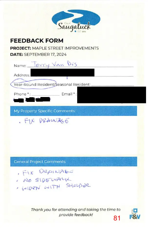
This page is a scanned image with no text layer. The PDF of these pages has it at full resolution.