
Council Agenda item 13A
Ordinance 260323-A - An Ordinance to Amend the Zoning Ordinance and Zoning Map of the City of Saugatuck by Approving a Planned Unit Development Overlay and Associated Plan for 640 Water Street. (Roll Call)
City Council, Monday, March 23, 2026
Download these 39 pages, 14.5 MB Whole packet, 220 pages, 25.4 MB
Page 131
Text of page 131
To:
City of Saugatuck, City Council
From:
Grayson Moore, Director of Planning & Zoning
Meeting Date:
March 23, 2026
RE:
640 Water Street, PUD Proposal
City Commissioners, At its March 19, 2026 meeting, the Planning Commission held a public hearing and reviewed the applicant’s proposal for demolition of the existing structure and construction of a new two-story building at 640 Water Street. As part of this review, the Planning Commission considered the proposed Planned Unit Development (PUD) ordinance to amend the City’s Zoning Map, along with the revised architectural design. The memo presented at the December 18, 2025 Planning Commission meeting has been included for reference as to how the conditions of the Zoning Ordinance have been met. Please note the following related zoning changes which have been made since the Memo dated December 12, 2025: • •
Waterfront setback pertaining to the trash enclosure has been met. Waterfront pathway access easements have been presented.
Following discussion at its March 19, 2026 Meeting, the Planning Commission voted to recommend approval of the proposed “Ordinance to Amend the Zoning Ordinance and Zoning Map of the City of Saugatuck by Approving a Planned Unit Development Overlay and Associated Plan for 640 Water Street,” as presented by staff. The proposal has also been reviewed by the Historic District Commission (HDC). After revisions made following the January meeting, the HDC indicated that the overall building design is acceptable. Final approval is contingent upon the applicant demonstrating proposed exterior materials at the April 2, 2026 HDC meeting. At this stage in the PUD process, the City Council is asked to hold a public hearing and review the following: • Proposed site plans and floor plans
Page 132
Text of page 132
Easement agreements Associated development documents Ordinance amendment to the Zoning Map
The Council may approve, approve with conditions, deny, or table the request. Any conditions imposed must be reasonably related to the following standards: • • • • • •
To insure that public services and facilities affected by the proposed development will be capable of accommodating increased public service loads caused by the development; To protect the natural environment and conserve natural resources and energy; To insure compatibility with adjacent uses of land; To promote the use of land in a socially and economically desirable manner; To protect the public health, safety and welfare of the individuals in the development and those immediately adjacent, and the community as a whole; To achieve the intent and purpose of this chapter
Staff recommends tabling the request to allow for completion and review of final floor plans, easement agreement, and any necessary refinements to the ordinance language. A sample motion has been provided below. Motion to postpone a decision of the proposed Planned Unit Development to April 13, 2026 to allow finalization of the following: 1. 2. 3. 4.
Easement agreement Floor plans and overall site plan Historic District Commission approval of materials Final ordinance language
Respectfully submitted,
Page 133
Text of page 133
MEMORANDUM City of Saugatuck Planning Commission Memo Date: Request: Address: Parcel: Lot Size: Complete: City Staff:
December 12, 2025 PUD Rezoning 640 Water Street 03-57-300-030-00 5,487 s.f. Yes Grayson Moore
Meeting Date: Applicant: Project Name: Plan Date: Zoning District: Recommendation: Consultant:
December 18, 2025 Daniel Boggs AMK Prop. Saugatuck Bldg. November 18, 2025 C-2 DWP Table Item David M. Jirousek, AICP
Overview The applicant proposes redevelopment of the property at 640 Water Street within the Downtown Waterfront Preservation (C-2 DWP) District through approval of a Planned Unit Development (PUD). The site is approximately 0.13 acres (5,487 square feet) and is currently occupied by an existing one-story commercial building that is proposed for demolition. This memo addresses the PUD process, zoning compliance, and approval standards. Planned Unit Development The purpose of the PUD process is to allow flexible, well-designed development that provides measurable public benefits such as open space preservation, environmental protection, compatible design, and public access, while remaining consistent with the Master Plan and the capacity of public services. The process includes rezoning the property to apply a PUD Overlay Zoning District and approval of the associated PUD plan. The general process is as follows: 1. Pre-application conference 2. Planning Commission public hearing, review, and recommendation 3. City Council public hearing and decision
102 Butler Street P.O. Box 86 Saugatuck, MI 49453 Phone: 269-857-2603 Website: www.saugatuckcity.com
Page 134
Text of page 134
City of Saugatuck Planning Commission 640 Water Street December 12, 2025 Page 2
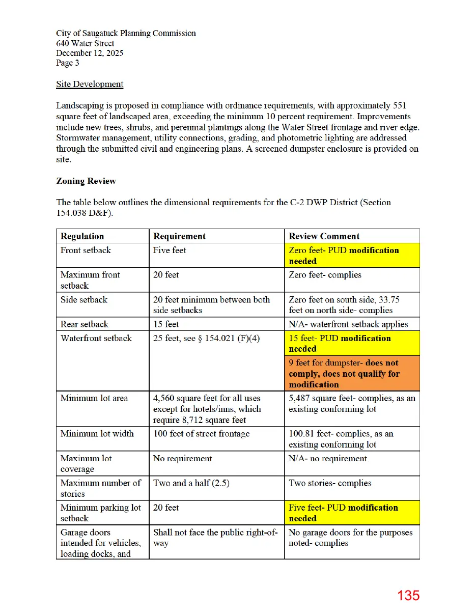
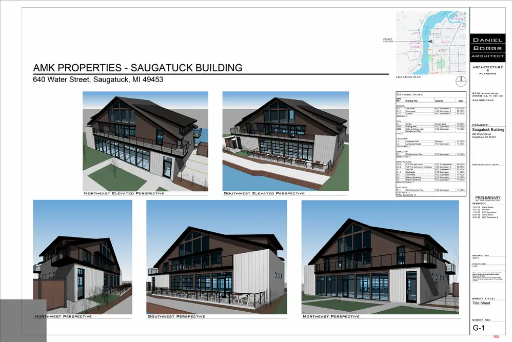
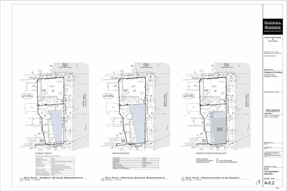
Downtown Waterfront Preservation District For background consideration and context, the Downtown Waterfront Preservation (C-2 DWP) District is intended to support a mix of commercial, residential, recreational, and mixed-use development while carefully managing redevelopment to protect and enhance the Kalamazoo River waterfront. The district prioritizes preserving river views, improving public access to the shoreline, and ensuring that new development complements the waterfront setting. Its objectives include strengthening connections between downtown and the river, expanding public access and recreation opportunities, preserving the area’s historic and architectural character, encouraging economic revitalization through compatible development and reuse, promoting high-quality design, and balancing residential growth, employment, and public benefits to support a vibrant downtown waterfront. Proposal The proposal seeks to redevelop a constrained waterfront parcel with a compact, mixed-use structure that activates the street and riverfront, and uses the PUD process to address site limitations and dimensional constraints. Land Use The project includes the construction of a two-story mixed-use building oriented toward Water Street and the Kalamazoo River. The first floor is proposed to contain a retail/commercial tenant space, including a commercial kitchen and an outdoor riverfront dining patio. The second floor includes three dwelling units, consistent with allowable upper-story residential use in the C-2 DWP District, which are intended to serve as short-term rentals. Building The building footprint occupies much of the shallow lot, necessitating dimensional deviations addressed through the PUD, including a zero-foot front setback and a reduced waterfront setback of approximately 15 feet (compared to the standard 25 feet). The building is two stories and approximately 25.5 feet at mid-roof (30.5 feet at the ridge), which is within the district's maximum permitted height. Architecturally, the building features fiber-cement board-and-batten siding, aluminum storefront glazing, standing-seam metal roofing, balconies with metal railings, and a design intended to reflect the character of downtown Saugatuck and the waterfront setting. Parking and Mobility The site plan provides four off-street parking spaces, although the C-2 DWP District is exempt from minimum parking requirements. Pedestrian circulation improvements include new concrete sidewalks, patios, and paved areas, as well as emergency vehicle access. A PUD modification is required for the five (5) foot front setback.
Page 135
This page is a scanned image with no text layer. The PDF of these pages has it at full resolution.
Page 136
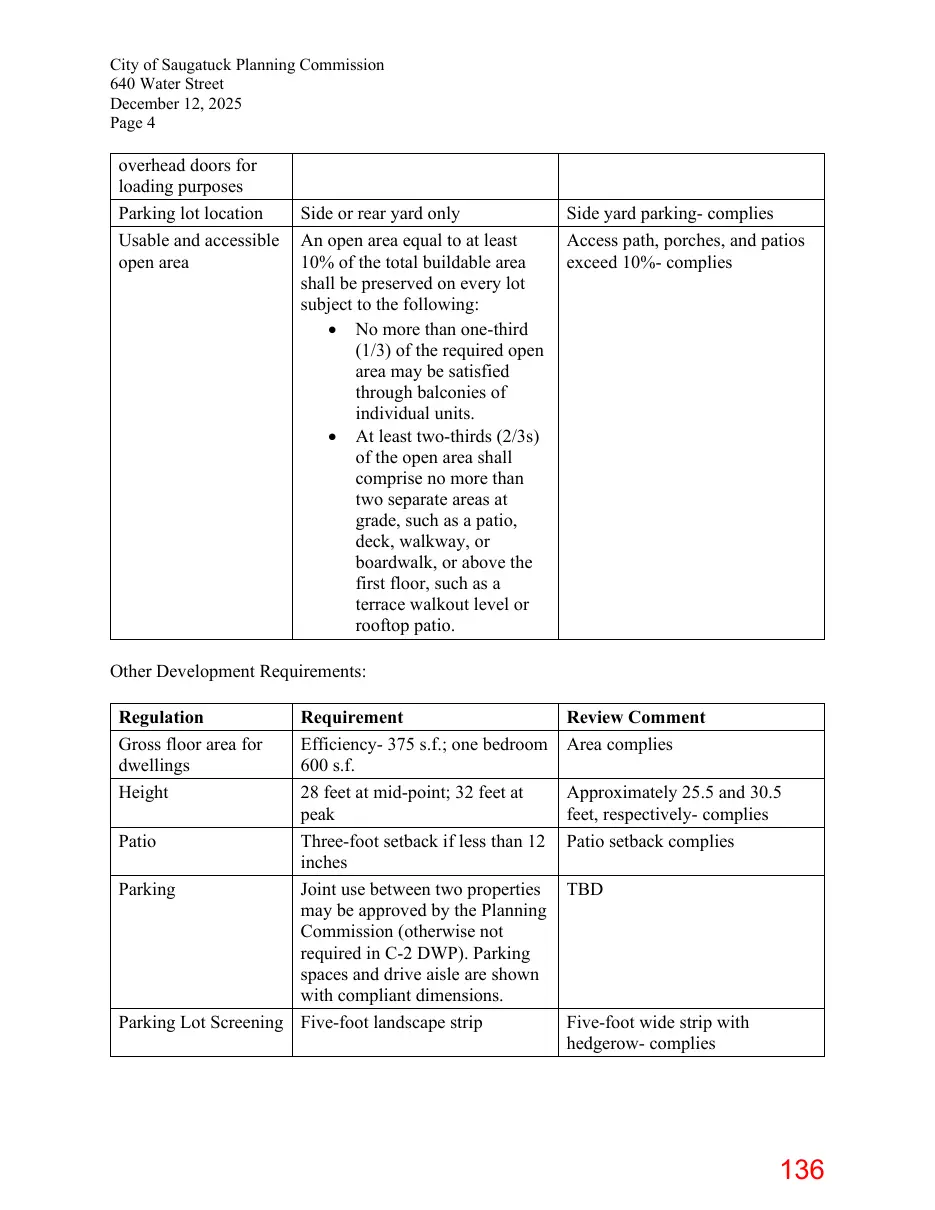
Text of page 136
City of Saugatuck Planning Commission 640 Water Street December 12, 2025 Page 4
overhead doors for loading purposes Parking lot location Usable and accessible open area
Side or rear yard only An open area equal to at least 10% of the total buildable area shall be preserved on every lot subject to the following: • No more than one-third (1/3) of the required open area may be satisfied through balconies of individual units. • At least two-thirds (2/3s) of the open area shall comprise no more than two separate areas at grade, such as a patio, deck, walkway, or boardwalk, or above the first floor, such as a terrace walkout level or rooftop patio.
Side yard parkingcomplies Access path, porches, and patios exceed 10%- complies
Other Development Requirements: Regulation Gross floor area for dwellings Height
Requirement Efficiency375 s.f.; one bedroom 600 s.f. 28 feet at mid-point; 32 feet at peak Patio Three-foot setback if less than 12 inches Parking Joint use between two properties may be approved by the Planning Commission (otherwise not required in C-2 DWP). Parking spaces and drive aisle are shown with compliant dimensions. Parking Lot Screening Five-foot landscape strip
Review Comment Area complies Approximately 25.5 and 30.5 feet, respectivelycomplies Patio setback complies TBD
Five-foot wide strip with hedgerowcomplies
Page 137
Text of page 137
City of Saugatuck Planning Commission 640 Water Street December 12, 2025 Page 5
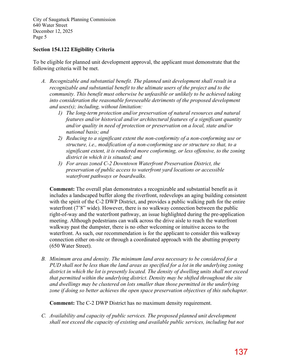
Section 154.122 Eligibility Criteria To be eligible for planned unit development approval, the applicant must demonstrate that the following criteria will be met. A. Recognizable and substantial benefit. The planned unit development shall result in a recognizable and substantial benefit to the ultimate users of the project and to the community. This benefit must otherwise be unfeasible or unlikely to be achieved taking into consideration the reasonable foreseeable detriments of the proposed development and uses(s); including, without limitation: 1) The long-term protection and/or preservation of natural resources and natural features and/or historical and/or architectural features of a significant quantity and/or quality in need of protection or preservation on a local, state and/or national basis; and 2) Reducing to a significant extent the non-conformity of a non-conforming use or structure, i.e., modification of a non-conforming use or structure so that, to a significant extent, it is rendered more conforming, or less offensive, to the zoning district in which it is situated; and 3) For areas zoned C-2 Downtown Waterfront Preservation District, the preservation of public access to waterfront yard locations or accessible waterfront pathways or boardwalks. Comment: The overall plan demonstrates a recognizable and substantial benefit as it includes a landscaped buffer along the riverfront, redevelops an aging building consistent with the spirit of the C-2 DWP District, and provides a public walking path for the entire waterfront (7’8” wide). However, there is no walkway connection between the public right-of-way and the waterfront pathway, an issue highlighted during the pre-application meeting. Although pedestrians can walk across the drive aisle to reach the waterfront walkway past the dumpster, there is no other welcoming or intuitive access to the waterfront. As such, our recommendation is for the applicant to consider this walkway connection either on-site or through a coordinated approach with the abutting property (650 Water Street). B. Minimum area and density. The minimum land area necessary to be considered for a PUD shall not be less than the land areas as specified for a lot in the underlying zoning district in which the lot is presently located. The density of dwelling units shall not exceed that permitted within the underlying district. Density may be shifted throughout the site and dwellings may be clustered on lots smaller than those permitted in the underlying zone if doing so better achieves the open space preservation objectives of this subchapter. Comment: The C-2 DWP District has no maximum density requirement. C. Availability and capacity of public services. The proposed planned unit development shall not exceed the capacity of existing and available public services, including but not
Page 138
Text of page 138
City of Saugatuck Planning Commission 640 Water Street December 12, 2025 Page 6
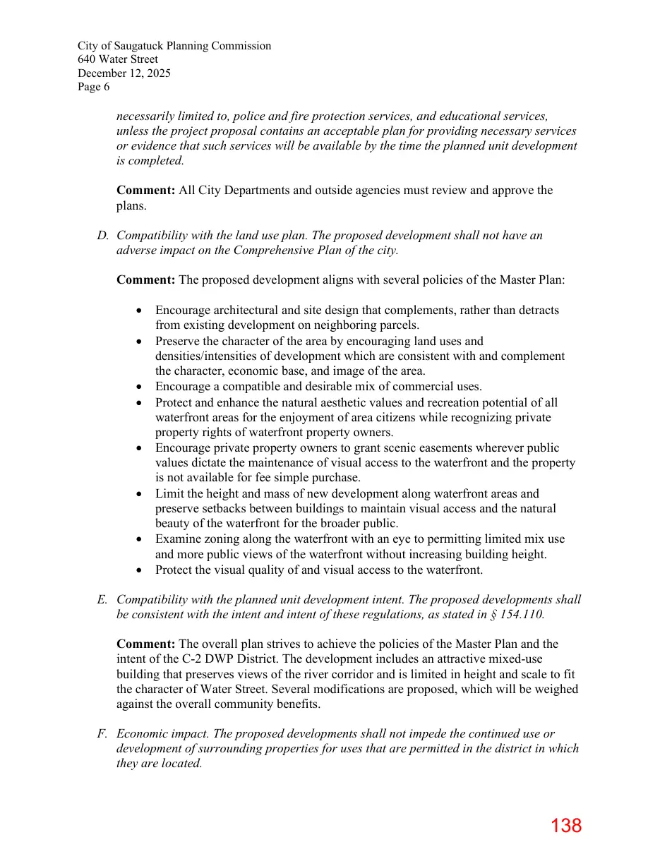
necessarily limited to, police and fire protection services, and educational services, unless the project proposal contains an acceptable plan for providing necessary services or evidence that such services will be available by the time the planned unit development is completed. Comment: All City Departments and outside agencies must review and approve the plans. D. Compatibility with the land use plan. The proposed development shall not have an adverse impact on the Comprehensive Plan of the city. Comment: The proposed development aligns with several policies of the Master Plan: • • • • • • • •
Encourage architectural and site design that complements, rather than detracts from existing development on neighboring parcels. Preserve the character of the area by encouraging land uses and densities/intensities of development which are consistent with and complement the character, economic base, and image of the area. Encourage a compatible and desirable mix of commercial uses. Protect and enhance the natural aesthetic values and recreation potential of all waterfront areas for the enjoyment of area citizens while recognizing private property rights of waterfront property owners. Encourage private property owners to grant scenic easements wherever public values dictate the maintenance of visual access to the waterfront and the property is not available for fee simple purchase. Limit the height and mass of new development along waterfront areas and preserve setbacks between buildings to maintain visual access and the natural beauty of the waterfront for the broader public. Examine zoning along the waterfront with an eye to permitting limited mix use and more public views of the waterfront without increasing building height. Protect the visual quality of and visual access to the waterfront.
E. Compatibility with the planned unit development intent. The proposed developments shall be consistent with the intent and intent of these regulations, as stated in § 154.110. Comment: The overall plan strives to achieve the policies of the Master Plan and the intent of the C-2 DWP District. The development includes an attractive mixed-use building that preserves views of the river corridor and is limited in height and scale to fit the character of Water Street. Several modifications are proposed, which will be weighed against the overall community benefits. F. Economic impact. The proposed developments shall not impede the continued use or development of surrounding properties for uses that are permitted in the district in which they are located.
Page 139
Text of page 139
City of Saugatuck Planning Commission 640 Water Street December 12, 2025 Page 7
Comment: The business use, as well as the short-term rental accommodations on the second floor, will not negatively impact surrounding properties or the district as a whole. The concept will be consistent and compatible with nearby land uses. G. Unified control of property. The proposed development shall be under single ownership or control such that there is a single person or entity having responsibility for completing the project in conformity with the planned unit development regulations. This provision shall not prohibit a transfer of ownership or control, provided that notice of the transfer is given immediately to the Zoning Administrator. Comment: The development is proposed to be under single ownership and control. H. Dedication of utilities and roads. Roads within the PUD development not associated with access to individual commercial or residential units shall be dedicated to the city. Likewise, utility easements shall be conveyed to the city. Utility easements and roads in PUD developments approved prior to the enactment of this chapter may remain in private ownership. Comment: No new streets are proposed, and any necessary utility easement will be established if directed by the City’s consulting engineer. Section 154.113 Project Design Standards In considering any application for approval of a planned unit development proposal filed according to the procedures of § 154.115 and application and data requirements of § 154.114, the Planning Commission and City Council shall make their determinations on the basis of standards set forth for site plan review, the eligibility criteria of § 154.112, as well as the following standards and requirements. A. Minimum lot area. Planned unit developments may be approved only on contiguous properties containing a minimum of three acres under single ownership. Projects with an underlying zoning designation of C-2 Downtown Waterfront Preservation District have no minimum acreage to qualify for planned unit development review. Comment: There is no minimum qualifying acreage in the C-2 DWP District. B. Compatibility with adjacent uses. The proposed planned unit development shall set forth specifications with respect to height, setbacks, density, parking, circulation, landscaping, views and other design and layout features which exhibit due regard for the relationship of the development to surrounding properties and the uses thereon. In determining whether this requirement has been met, consideration shall be given to the following: 1) The bulk, placement and materials of construction of proposed structures;
Page 140
Text of page 140
City of Saugatuck Planning Commission 640 Water Street December 12, 2025 Page 8
2) The location and screening of vehicular circulation and parking areas in relation to surrounding development; 3) The location and screening of outdoor storage, outdoor activity or work areas, and mechanical equipment in relation to surrounding development; 4) The hours of operation of the proposed uses; and 5) The provision of landscaping and other site amenities. Comment: The business use, as well as the short-term rental accommodations on the second floor, will not negatively impact surrounding properties or the district as a whole. The concept will be consistent and compatible with nearby land uses. Landscaping is proposed within the public right-of-way and along the waterfront, enhancing the aesthetic appeal. The dumpster is proposed to be screened, although it is currently shown within the waterfront setback area. C. Permitted uses. Any land use authorized in the underlying district may be included in a planned unit development as a principal or accessory use, provided that public health, safety and welfare are not impaired. Comment: The first floor includes retail space and a commercial kitchen. Although retail and restaurant uses are both allowable in the C-2 DWP District, grouping them in a single tenant space is unusual and should be clarified. Upper-floor apartments and short-term rentals are also allowable, so all proposed uses may be authorized as part of the PUD project. D. Application base regulations. Unless waived or modified in accordance with division (E) below, the yard and lot coverage, parking, loading, landscaping, lighting and other standards for the underlying district(s) shall be applicable for uses proposed as a part of a planned unit development. Mixed uses shall comply with the regulations applicable for each individual use, as outlined above, except that if regulations are inconsistent with each other, the regulations applicable to the most restrictive use shall apply. However, a special use that is part of a PUD shall not be separately processed as a special use, instead, it shall be processed as part of the PUD application. Comment: The zoning compliance review considered the C-2 DWP District requirements and all other applicable site development rules. Certain modifications are requested as part of the PUD consideration. E. Regulatory flexibility. 1) To encourage flexibility and creativity consistent with the planned unit development concept, departures from the regulations in division (D), above, may be permitted, subject to review and approval by the Planning Commission and City Council. For example, such departures may include but are not limited to modifications to: lot dimensional standards; floor area standards; setback requirements; parking, loading and landscaping requirements; and similar
Page 141
Text of page 141
City of Saugatuck Planning Commission 640 Water Street December 12, 2025 Page 9
requirements. These modifications may be permitted only if they will result in a higher quality of development or a better design or layout than would be possible without the modifications. 2) For areas zoned Downtown Waterfront Preservation District, departures from the minimum side setback, minimum rear setback (reductions up to ten feet), and maximum lot coverage requirements will be considered by the Planning Commission and City Council when at least 33% of the waterfront yard is available for public access or if 100% of the waterfront yard width can be traversed from one side to the other by a waterfront walkway or boardwalk. Comment: The zoning compliance review considered the C-2 DWP District requirements and all other applicable site development rules. Certain modifications are requested as part of the PUD consideration. Concerning the required 25-foot waterfront setback, a reduction of 10 feet is authorized through this process, as 100% of the waterfront yard is proposed to include a walkway (7’8” wide). F. Permitted mix of uses. Where the existing underlying zoning district is residential, nonresidential uses shall be permitted as part of a planned unit development which also contains a residential component, provided that the applicant demonstrates that the residential uses will be predominant and the non-residential use will not create a nuisance for abutting property. The Planning Commission shall determine predominance of use after taking into account the following criteria as they apply to each of the proposed uses: extent to which it serves residents in the PUD compared to others who travel to the site, amount of traffic generated; hours of operation or use; noise, odors and overall impact on adjoining uses; land area allocated to each use; and, building area allocated to each use. Where residential development is the principal use and a commercial component of the PUD is predominantly designed to serve persons other than those who reside in the PUD, it shall not be permitted. Comment: The proposed uses complement each other and are not anticipated to cause a nuisance to nearby properties. G. Open space requirements. Open space shall at least equal that which would be provided under the maximum lot coverage requirements of the underlying district. Open space shall be in large contiguous units that are easily accessible and usable. Small discontinuous areas of open space are contrary to the intent of this section, although it may be necessary to permit up to 20% of the total open space area in small discontinuous areas on a given parcel in order to achieve quality design and/or function of the balance of the PUD. Any land without a structure within the boundaries of the site may be included as required open space, except for land in the floodplain, subject to an easement, submerged lands and land contained in public or private street right-of-way. The required open space shall be set aside by the developer through an irrevocable conveyance, such as a deed restriction or covenant that runs with the land, assuring that
Page 142
Text of page 142
City of Saugatuck Planning Commission 640 Water Street December 12, 2025 Page 10
the open space will be developed according to the site plan and never change to another use unless the PUD plan is properly amended according to the requirements of § 154.117. The conveyance shall: 1) Ensure the open space is under single ownership or control, such that there is a single person or entity having proprietary responsibility for the open space. The applicant shall provide sufficient documentation of ownership or control in the form of agreements, contracts, covenants, master deeds and/or deed restrictions that indicate that open space will be held as proposed in perpetuity; 2) Guarantee to the satisfaction of the City Council that all open space portions of the development will be maintained in the manner approved. Documents shall be presented to the satisfaction of the city attorney that bind all successors and future owners in fee title to maintenance commitments made as a part of the approval of the open space; and 3) Provide for maintenance to be undertaken by the city in the event that the dedicated open space is inadequately maintained, or is determined by the city to be a public nuisance, with the assessment of costs upon the property owners within the PUD. Comment: Since there is no maximum lot coverage applicable to the C-2 DWP District, there is no minimum open space requirement related to the PUD. However, the C-2 DWP District requires a minimum amount of “usable and accessible open area,” which has been satisfied. H. Frontage and access. Planned unit developments shall front onto a street with adequate capacity to safely accommodate the traffic of the development without unreasonably congesting the street. Road improvements contiguous to the site of the PUD that would improve traffic safety and reduce congestion may be required as a condition of a development approval. Access and egress openings from the development onto a public or private street shall be limited to one per 200 feet. The nearest edge of any entrance or exit drive shall be located no closer than 100 feet from any street or road intersection (measured from the nearest intersection right-of-way line). All requirements of §§ 154.060 through 154.068 shall also apply to planned unit developments. Comment: The proposed PUD has direct frontage on Water Street and appropriate access to its four-car parking lot. No new driveways are proposed beyond the existing shared driveway. I. Utilities; privacy for dwelling units. The design of a planned unit development, including electric, telephone and cable television lines, shall be placed underground, wherever feasible or required by the city. Comment: All utilities are proposed underground as feasible.
Page 143
Text of page 143
City of Saugatuck Planning Commission 640 Water Street December 12, 2025 Page 11
J. Privacy for dwelling units. The design of a planned unit development shall provide visual and sound privacy for all dwelling units within and surrounding the development. Fences, walks and landscaping shall be used in the site design to protect the privacy of dwelling units. Comment: The proposed short-term rental apartment units are located on the second floor, and porches are oriented toward the waterfront and Water Street. Issues concerning privacy are not anticipated. K. Emergency access. The configuration of buildings, driveways and other improvements shall permit convenient and direct emergency vehicle access. Comment: The PUD plan must be reviewed and approved by the Fire Department. L. Pedestrian and vehicular circulation. A pedestrian circulation system shall be provided that is isolated as completely as possible from the vehicular circulation system. The layout of vehicular and pedestrian circulation routes shall respect the pattern of existing or planned streets, sidewalks and bicycle pathways in the vicinity of the site. Comment: As mentioned earlier, there is no separate pedestrian access to the waterfront pathway. Although pedestrians can cross the drive aisle to reach the waterfront walkway past the dumpster, there is no other welcoming or intuitive access to the waterfront. As such, our recommendation is for the applicant to consider this connection either on-site or through a coordinated approach with the abutting property (650 Water Street). M. Minimum spacing. Unless modified in accordance with division (E), minimum spacing between detached buildings shall not be less than 20 feet measured from the nearest point of the foundation. In no case shall spacing be less than required under the Building Code. Comment: The proposed building spacing complies with the underlying C-2 DWP District side setback requirements. N. Building length. No multiple-family building shall exceed 120 feet in length along any one elevation of the building measured between its two furthest points unless modified in accordance with division (E). Comment: The mixed-use building does not exceed 63 feet in width. O. Sensitive natural features. All sensitive natural features such as drainage ways and streams, wetlands, lands within the 100-year floodplains, and stream or river banks (which by virtue of soils and slope may create highly erodible hazards to the public health and safety) shall remain unencumbered by any principal or accessory buildings and structures. However, areas zoned Downtown Waterfront Preservation District may
Page 144
Text of page 144
City of Saugatuck Planning Commission 640 Water Street December 12, 2025 Page 12
be developed within special flood hazard areas as designated in the current Flood Insurance Rate Map (FIRM) if the lowest floor level is at least one foot above the Base Flood Elevation (BFE). Comment: As a redevelopment project, no sensitive natural features will be removed. Additionally, a waterfront setback will be maintained, and a vegetative landscaped area will be established between the patio and waterfront walkway. P. Natural vegetation strip along streams. Drainage ways and streams shall be protected by a 25 foot natural vegetation strip or public easement measured from the centerline of the drainage ways or streams and measured from the ordinary high water mark for other surface water bodies. Comment: This standard is not applicable. The waterfront setback provision and C-2 DWP District provisions address development between Water Street and the Kalamazoo River. Q. Buffer zone along property lines. Natural vegetation, planted or landscaped buffer areas of 25 feet width are required wherever feasible along all exterior boundaries of the property to be developed as a PUD. Comment: As a downtown infill project, side buffer areas were not contemplated during the establishment of the C-2 DWP District and are not recommended. R. Parking areas. The parking area shall be designed so as to maximize and encourage the use of landscape breaks and/or buffers to minimize the unbroken expanses of surfaced area. However, landscaped areas in parking lots shall be large enough to support thriving vegetation and shall be preferred over many small landscape islands. Comment: The proposed parking lot accommodates four (4) vehicles, so this standard is not applicable. However, the parking lot is screened from the street right-of-way by a proposed wintergreen boxwood hedgerow. S. Common property. 1) Common property in the PUD is a parcel or parcels of land, a privately owned road, or roads, together with the improvements thereon, the use and enjoyment of which are shared by the owners and occupants of the individual building sites or condominiums within the PUD. When common property exists, the ownership of the common property shall be private. 2) When privately owned, arrangements must be made for the improvements, operation and maintenance of the common property and facilities, including private streets, drives, service parking and recreational facilities (such as a club house or tennis courts).
Page 145
Text of page 145
City of Saugatuck Planning Commission 640 Water Street December 12, 2025 Page 13
3) The applicant shall guarantee to the satisfaction of the city attorney that all common property portions of the development will be maintained in perpetuity and in the manner approved. Documents shall be presented that bind all successors and future owners in fee title to commitments made as a part of the approval of the common property. 4) This provision shall not prohibit a transfer of ownership or control, provided notice of the transfer is provided to the city and the land use continues as approved. Comment: The applicant shall ensure that the waterfront pathway, as well as access to the waterfront, is preserved to the satisfaction of the City Attorney. T. Easements across common property. When common property exists in private ownership, the owners shall grant easements, over, under and through the property to the city as are required for public purposes. Comment: The applicant shall ensure that the waterfront pathway, as well as access to the waterfront, is preserved to the satisfaction of the City Attorney. Additionally, as the driveway encroaches onto abutting property at 650 Water, the applicant shall ensure that an easement is established. Section 154.114 Application and Data Requirements Application for planned unit development approval shall include all data requirements for site plan review as specified in §§ 154.060 through 154.068. In considering any application for approval of a planned unit development proposal, the Planning Commission and City Council shall make their determinations on the basis of standards set forth for site plan review, as well the following standards and requirements. In addition, the application shall include the following: A. An overall plan for the planned unit development. The overall plan shall graphically represent the development concept using maps and illustrations to indicate each type of use, square footage or acreage allocated to each use, approximate locations of each principal structure and use in the development, setbacks and typical layouts and elevations for each type of use. The overall plan shall clearly delineate each type of residential use; office, commercial and other nonresidential use; each type of open space; community facilities and public areas; and other types of land use; B. Map and written explanation. A map and written explanation of the relationship of the proposed planned unit development to the city’s Comprehensive Plan; C. Conformance with the planned unit development concept. The overall design and all uses proposed in connection with a planned unit development shall be consistent with and promote the intent of the planned unit development concept described in § 154.110, as well as with the specific project design standards set forth herein; D. Compatibility with adjacent uses. The proposed planned unit development shall set forth specifications with respect to height, setbacks, density, parking, circulation, landscaping,
Page 146
Text of page 146
City of Saugatuck Planning Commission 640 Water Street December 12, 2025 Page 14
views and other design and layout features which exhibit due regard for the relationship of the development to the surrounding properties and uses thereon. In determining whether this requirement has been met, consideration shall be given to the following: 1) The bulk, placement and materials of construction of proposed structures; 2) The location and screening of vehicular circulation and parking areas in relation to the surrounding development; 3) The location and screening of outdoor storage, outdoor activity or work areas, and mechanical equipment in relation to surrounding development; 4) The hours of operation of the proposed uses; and 5) The provision of landscaping and other site amenities. E. Public services. The proposed planned unit development shall not exceed the capacity of existing and available public services, including but not necessarily limited to utilities, public roads, police and fire protection services and educational services, unless the project proposal contains an acceptable plan for providing necessary services or evidence that such services will be available by the time the planned unit development is completed; F. Impact of traffic. The planned unit development shall be designed to minimize the impact of traffic generated by the proposed development on surrounding areas; G. Accommodations for pedestrian traffic. The planned unit development shall be designed with a sidewalk network to accommodate safe pedestrian circulation throughout and along the perimeter of the site, without interference from vehicular traffic; H. Compliance with applicable regulations. The proposed planned unit development shall be in compliance with all applicable federal, state and local laws and ordinances; I. Legal documentation of single ownership or control. The documentation shall be in the form of agreements, contracts, covenants and deed restriction which indicate that the development can be completed as shown on the plans, and further, that all portions of the development that are not to be maintained at public expense will continue to be operated and maintained by the developers, their successors, or other authorized entity; J. Schedule. A specific schedule of the intended development and construction details, including the phasing or timing of all proposed improvements; and K. Draft. A draft of ownership and governance documents. These documents shall include the following: 1) Deeds of ownership; 2) Warranties guaranteeing ownership conveyed and described in the deeds; 3) A list of covenants, conditions and restrictions that are conditions of ownership upon the purchasers and owners in the planned unit development; and 4) Association bylaws (for example, condominium or homeowner’s association bylaws) which describe how the association is organized; the duties of the association to operate, manage and maintain common elements of the planned unit development; and, the duties of individual shareholders to manage and maintain their own units. Comment: The application is primarily complete. However, the applicant must provide information concerning I, J, and K.
Page 147
Text of page 147
City of Saugatuck Planning Commission 640 Water Street December 12, 2025 Page 15
Recommendation While we support the overall development concept, we recommend that the Planning Commission table this item to allow the applicant to address concerns regarding waterfront pathway access and the location of the dumpster within the waterfront setback area. If these issues are addressed to the Planning Commission's satisfaction, a positive recommendation could be made to the City Council.
Page 148
Text of page 148
CITY COUNCIL CITY OF SAUGATUCK ALLEGAN COUNTY, MICHIGAN ORDINANCE NO. 260323-A AN ORDINANCE TO AMEND THE ZONING ORDINANCE AND ZONING MAP OF THE CITY OF SAUGATUCK BY APPROVING A PLANNED UNIT DEVELOPMENT OVERLAY AND ASSOCIATED PLAN FOR 640 WATER STREET Section 1. Amendment to Section 154.043 of the Zoning Ordinance. Subject to the terms and conditions of this Ordinance and the development plan (“Plan”) associated with the Planned Unit Development (“PUD)” request submitted by Daniel Boggs (the “Applicant”) on behalf of AMK Holdings, LLC, the City of Saugatuck Zoning Ordinance is hereby amended by an amendment of Section 154.043, the Zoning Map, to rezone the following land (“Subject Property”) to PUD Overlay with the base zoning district remaining Downtown Waterfront Preservation District (DWP). 640 Water Street (FROM COVENANT DEED LIBER 4875, PAGE 157 DOCUMENT NO. 2023010350, ALLEGAN COUNTY RECORDS) LOT(S) 29, 30 AND NORTH ONE-HALF OF LOT 31 OF KALAMAZOO PLAT, ACCORDING TO THE PLAT THEREOF RECORDED IN LIBER 111 OF DEEDS, PAGE 551 OF ALLEGAN COUNTY RECORDS. Section 2. Terms and Conditions of the Planned Unit Development Overlay District. The rezoning of land to PUD Overlay and approval of the Plan submitted by the Applicant are expressly subject to the following terms and conditions: A. Site Development. The development of the Subject Property shall comply in all respects with the Plan, last revised November 18, 2025, with supplemental revisions last revised December 19, 2025 (Sheet A-1), except if amended in accordance with the City of Saugatuck Zoning Ordinance. 1
Page 149
Text of page 149
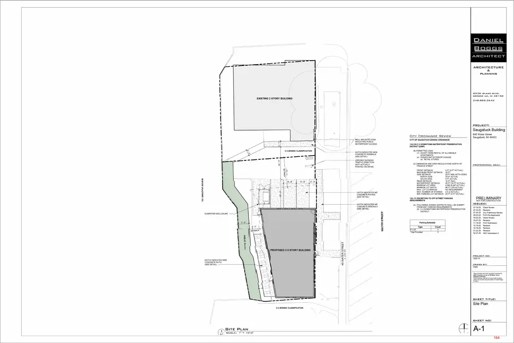
B. Land Use. The Plan includes construction of a two-story mixed-use building oriented toward Water Street and the Kalamazoo River. The first floor includes one retail/commercial tenant space with a commercial kitchen and an outdoor riverfront dining patio. The second floor includes three (3) dwelling units as upper-story residential use, intended for, but not limited to, short-term rental occupancy. C. Building. The building will be no higher than (2) stories, 25.5 feet at the mid-roof, and 30.5 feet at the roof ridge. The building includes fiber-cement board-and-batten siding, aluminum storefront glazing, standing-seam metal roofing, and balconies with metal railings, subject to the Historic District Commission (HDC) approving the materials. D. Parking and Mobility. The Plan includes three (3) off-street parking spaces accessible via an existing driveway along Water Street. Pedestrian circulation improvements include new concrete sidewalks, patios, and paved pedestrian areas. Vehicle and emergency access shall be accommodated by a single driveway to the proposed parking lot. All vehicular and pedestrian access easements shall be reviewed and approved by the City Attorney. After review, the City Attorney may require modification of the terms of the easements before the easements receive the required approval from the City Attorney. E. Landscaping and Screening. The site shall incorporate 551 square feet of landscaped area, including new trees, shrubs, and perennial plantings along the Water Street frontage and river edge in accordance with the Plan. The dumpster shall be installed where shown on the Plan and fully screened with a six-foot (6’) high enclosure. F. Stormwater and Utilities. Final stormwater management infrastructure and public water and sewer utility connection plans shall be submitted and approved by all applicable City departments and the City Engineer.
Page 150
Text of page 150
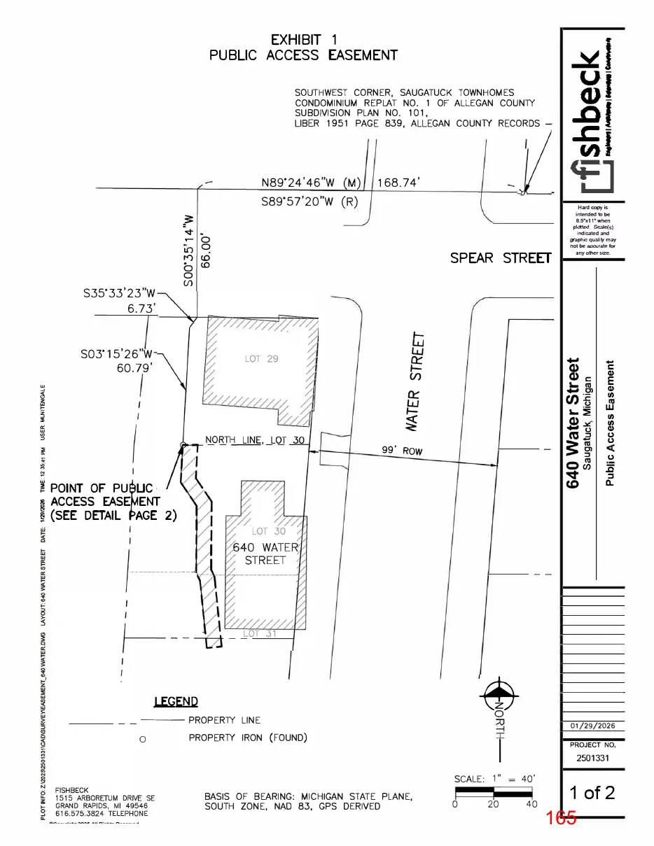
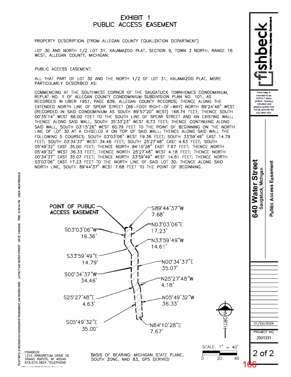
G. Fire Department Approval. The Applicant shall secure approval from the Saugatuck Township Fire Department prior to the issuance of a building permit. H. Zoning Requirements. The development of the Subject Property shall comply with all requirements of the DWP zoning district and all other applicable requirements except as modified by this Ordinance. The following PUD modifications are approved in accordance with Section 154.113(E)(1) and (2): 1. The front setback, as measured from the Water Street right-of-way, is reduced from five (5) feet to zero (0) feet. 2. The waterfront setback, as measured from the waterfront, is reduced from 25 feet to 15 feet. 3. The parking lot setback, as measured from the Water Street right-of-way, is reduced from 20 feet to five (5) feet. I. Waterfront Access. 1. The Plan includes a public waterfront walking path located within the waterfront yard area along the Kalamazoo River. 2. The waterfront path shall be no less than seven feet and eight inches (7’8”) wide, and it is intended to allow pedestrians to traverse 100% of the waterfront yard width from one side to the other. 3. Legal access from the Water Street right-of-way to the waterfront walking path shall be established by an easement crossing the property located at 650 Water Street. The connecting path shall be concrete, decking, or another material along the south side of the building at 650 Water Street, then cross the parking lot to the waterfront walking path along the Subject Property.
Page 151
Text of page 151
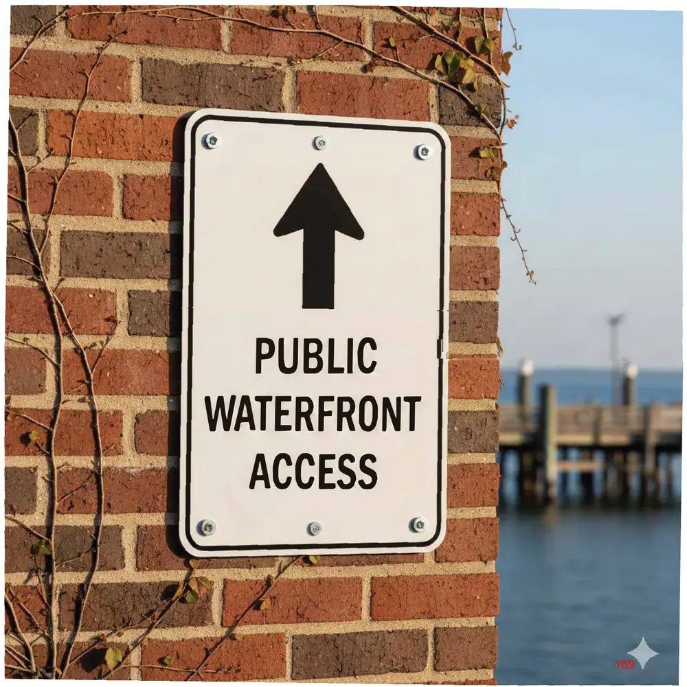
4. A sign shall be located near the intersection of the connecting path and the Water Street right-of-way, indicating public access to the waterfront walking path. The sign design shall be consistent with any applicable City of Saugatuck wayfinding signage design guidelines. 5. The mechanism or legal instrument that memorializes public waterfront access shall be reviewed and approved by the City Attorney and City Manager. After review, the City Attorney may require modification of the terms of the legal instrument before the legal instrument receives the required approval from the City Attorney. J. Historic District Committee Review. In accordance with City Code Section 154.03, the Applicant shall secure Historic District Committee (HDC) approval for the project before the demolition of the existing building, construction of the new building, and any other improvements that require review under this section. In the event that the HDC requires a change that is determined by the Zoning Administrator to be a minor or major amendment to the approved PUD materials, the Applicant shall be required to secure approval of the amendment prior to site development and construction of the new building. K. Signage. The Applicant shall prepare and submit a detailed signage plan that depicts all signage proposed for the project. All proposed signage shall comply with applicable requirements of the Zoning Ordinance and City Code. All signs shall be subject to the approval of the Zoning Administrator. Approval of the PUD shall not constitute approval of any future site signage. L. Phasing. The project shall be constructed in a single phase.
Page 152
Text of page 152
M. Application and Data Requirements. Prior to site development and issuance of a building permit, the Applicant shall provide the following for review and approval by the Zoning Administrator: 1. Legal Documentation of Single Ownership or Control. The documentation shall be in the form of agreements, contracts, covenants, and deed restrictions which indicate that the development can be completed as shown on the plans, and further, that all portions of the development that are not to be maintained at public expense will continue to be operated and maintained by the developers, their successors, or other authorized entity; 2. Schedule. A specific schedule of the intended development and construction details, including the phasing or timing of all proposed improvements; and 3. Draft of Ownership and Governance Documents. These documents shall include the following: a. Deeds of ownership; b. Warranties guaranteeing ownership conveyed and described in the deeds; c. A list of covenants, conditions, and restrictions that are conditions of ownership upon the purchasers and owners in the planned unit development; and d. Association bylaws (for example, condominium or homeowner’s association bylaws) which describe how the association is organized; the duties of the association to operate, manage, and maintain common elements of the planned unit development; and the duties of individual shareholders to manage and maintain their own units.
Page 153
Text of page 153
Section 3. Planned Unit Development Eligibility. The City Council determines that the Applicant has demonstrated that the project qualifies for PUD review and approval in accordance with Section 154.122 Eligibility: A. Recognizable and Substantial Benefit. The project delivers a recognizable community benefit by redeveloping an aging waterfront site, consistent with the C-2 DWP District's intent, and by incorporating riverfront landscaping and a public walking path. B. Minimum Area and Density. The parcel meets the minimum lot area required in the C-2 DWP District for the proposed uses, and the residential component (three upper-story dwelling units) is permitted in the district. The district does not establish a maximum density standard that the proposal would exceed. C. Availability and Capacity of Public Services. The development will be served by existing public services and infrastructure, subject to review and approval by applicable City departments and outside agencies. D. Compatibility with the Land Use Plan. The project is consistent with the City’s Comprehensive Plan policies on downtown reinvestment, compatible mixed-use development, waterfront protection, preservation of river views, and high-quality waterfront design. E. Compatibility with PUD Intent. The proposed redevelopment aligns with the intent of the PUD provisions by using design flexibility to address a constrained site while providing a higher-quality infill development that supports downtown activity and enhances the waterfront setting.
Page 154
Text of page 154
F. Economic Impact. The proposed commercial use and upper-story residential units are compatible with the downtown district and are not expected to impede surrounding properties or the continued use of nearby permitted uses. G. Unified Control of Property. The development is proposed under single ownership and control, ensuring a single responsible party to implement the project in accordance with the approved PUD Plan. H. Dedication of Utilities and Roads. No new public streets are proposed. Utility easements may be established if required during engineering review, but the project does not involve new roadway dedication. Section 4. Project Design Standards. The City Council determines that the project design standards and requirements outlined in Section 154.113 Project Design Standards have been met by the Applicant: A. Minimum Lot Area. The project is eligible for PUD review in the C-2 DWP District, which does not require a minimum acreage threshold for PUD consideration. B. Compatibility with Adjacent Uses. The building height, scale, placement, and architectural materials are generally compatible with the downtown and waterfront context. The Plan includes screening and landscaping elements intended to buffer site features, including parking and service areas. C. Permitted Uses. The proposed mix of uses (first-floor commercial/retail space and upperstory dwelling units) is allowed in the C-2 DWP District and may be authorized through the PUD approval. 7
Page 155
Text of page 155
D. Application Base Regulations. The Plan was reviewed against the underlying C-2 DWP District standards and applicable site development regulations. Where deviations are proposed (including reduced front, waterfront, and parking setbacks), they are addressed through the PUD modification process. E. Regulatory Flexibility. The proposal includes requested modifications to dimensional standards (including reduced front, waterfront, and parking setbacks). The waterfront walkway component supports the flexibility provisions applicable in the C-2 DWP District by providing continuous traversable access along the waterfront yard area. F. Permitted Mix of Uses. The project’s commercial and residential components are designed to operate together and are not expected to cause nuisance impacts on surrounding properties, consistent with the district's mixed-use intent. G. Open Space Requirements. While the C-2 DWP District does not impose a maximum lot coverage standard, the Plan provides usable, accessible open area through patios, porches, and the riverfront walkway, consistent with the district’s open area requirements. H. Frontage and Access. The Subject Property fronts on Water Street and provides access using the existing shared driveway arrangement. No additional drive openings are proposed beyond the current vehicle access point. I. Utilities. Utilities are proposed to be underground where feasible and will be subject to review and approval through the City Engineer and utility service providers.
Page 156
Text of page 156
J. Privacy for Dwelling Units. Residential units are located on the second floor, with balconies and outdoor areas oriented toward the river and Water Street. The site design does not identify privacy conflicts that would prevent approval. K. Emergency Access. Emergency vehicle access is shown on the Plan and remains subject to review and approval by the Saugatuck Township Fire Department. L. Pedestrian and Vehicular Circulation. The Plan includes new sidewalks, patios, and paved areas. The waterfront pathway will be accessible to the public through an easement located at 650 Water Street. M. Minimum Spacing. The development meets applicable spacing requirements through compliance with minimum side setbacks. Separation between off-site buildings shall adhere to applicable Building Code and Fire Code requirements. N. Building Length. The proposed building length is within the maximum length standard for multiple-family buildings. O. Sensitive Natural Features. The project maintains a 15-foot waterfront setback area and does not propose removing sensitive natural features. The river edge is buffered by landscaping and a setback space, as shown on the Plan. P. Natural Vegetation Strip Along Streams. This standard is addressed through the C-2 DWP waterfront setback and proposed waterfront yard landscaping.
Page 157
Text of page 157
Q. Buffer Zone Along Property Lines. Given the downtown infill context and lot constraints, large perimeter buffer strips are neither proposed nor expected for this type of waterfront redevelopment. R. Parking Areas. The parking area is small in scale and includes screening along the street frontage, which helps minimize visual impacts from paved areas. S. Common Property. The Plan includes a waterfront pathway intended for public access. The applicant must ensure the pathway and access are maintained and preserved for public access through appropriate legal documentation, subject to City Attorney review and approval. T. Easements Across Common Property. Where easements are necessary (including for the shared driveway and waterfront access), the applicant is expected to provide legal documentation to ensure long-term access and enforceability. All legal instruments, including those pertaining to the shared driveway and waterfront access, must be review and approved by the City Attorney. After review, the City Attorney may require modification of the terms of the legal instruments before the legal instruments receive the required approval from the City Attorney. Section 5. Expiration. Construction must be initiated under a PUD approval within one (1) year from the date of the issuance of a zoning permit. Upon receipt of a written request for an extension from the Applicant, an extension of up to one (1) year may be granted by the Planning Commission if the Planning Commission feels the nature of the problems preventing project initiation is legitimate, and that the approved Plan adequately represents current conditions on and surrounding the Subject Property. If the project is not initiated within 24 months of the original 10
Page 158
Text of page 158
approval, the PUD is cancelled. Thereafter, the project may proceed only if it is approved after the entire PUD process is repeated, starting with a new application. In the event that an approved PUD Plan becomes null and void, the City shall initiate proceedings to amend the zoning classification of the Subject Property. Section 6. Repeal. All Ordinances or parts of Ordinances in conflict herewith are hereby repealed. Section 7. Severability. The provisions of this Ordinance are declared severable. If any part of this Ordinance is declared invalid for any reason by a court of competent jurisdiction, that declaration does not affect or impair the validity of all other provisions that are not subject to that declaration. Section 8. Effective Date. This Ordinance shall take effect seven (7) days after publication of a notice of adoption of this Ordinance, unless referendum procedures are initiated under MCL 125.3402. If referendum procedures are initiated, this Ordinance will take effect in accordance with MCL 125.3402
YEAS:_____________________________________________________________ NAYS: ____________________________________________________________ ABSENT/ABSTAIN:_________________________________________________ ORDINANCE DECLARED ADOPTED. ____________________________________________ Holly Anderson City of Saugatuck, Mayor
Page 159
Text of page 159
CERTIFICATION I hereby certify that: 1. The above is a true copy of an ordinance adopted by the City of Saugatuck at a duly scheduled and noticed meeting of the City Council held on __________, _____ 2026, pursuant to the required statutory procedures. 2. A summary of the above ordinance was duly published in the ______________________ newspaper, a newspaper that circulates within the City of Saugatuck, on ___________, 2026. 3. Within 1 week after such publication, I recorded the above ordinance in a book of ordinances kept by me for that purpose, including the date of passage of the ordinance, the names of the members of the City Council voting, and how each member voted. ATTESTED: ___________________________________ Jamie Wolters City of Saugatuck, Clerk
Page 160
This page is a scanned image with no text layer. The PDF of these pages has it at full resolution.
Page 161
Text of page 161
DANIEL
BOGGS ARCHITECT ARCHITECTURE & PLANNING
PHOTO OF EXISTING BUILDING TO BE DEMOLISHED B538 ISLAND BLVD. GROSSE ILE, Ml 4B 1 38
24B.BBZ.3642
PROJECT:
Saugatuck Building 640 Water Street Saugatuck, Ml 49453
EAST STREETSCAPE
PROFESSIONAL SEAL:
PRELIMINARY
NOT FOR CONSTRUCTION
ISSUED: 01-23-26 02-04-26 02-27-26
PHOTO OF EXISTING BUILDING TO BE DEMOLISHED ON RIVER SIDE
HOC Preliminary Review Client Review HOC Submission 2
PHOTO OF 650 WATER STREET ON THE RIVER SIDE
PROJECT N □:
2025.13
DRAWN BY:
DWB These draNilgs have been specificaly prepared fa AMK Properties for use at 640 Water Street Saugatuck, Ml 49453 These draNilqs shal no1 be used at olher locations withoot the coosent and participatioo of Daniel Boggs ArcMect.
SHEET TITLE:
Streetscape PHOTO OF EXISTING RESIDENTIAL HOMES NORTH ACROSS STREET
SHEET N □:
G-1.1 161
Page 162
Text of page 162
DANIEL
BOGGS ARCHITECT ARCHITECTURE & PLANNING
B53B ISLAND BLVD. GROSSE ILE, Ml 4B 1 3B 24B.BBZ.3642
Wm Cary tug at Saugatuck fish docks.
Sewers's Joann fishing tug near present day Coghlin Park.
s History Center
Fisher Boy tug.
PROJECT:
Saugatuck Building 640 Water Street Saugatuck, Ml 49453
PROFESSIONAL SEAL:
PRELIMINARY
NOT FOR CONSTRUCTION
Saugatuck-D u'glas J,ist ry ' Fishing Tug Baldhead with the Saugatuck-Douglas Historical Museum in background.
ISSUED: Color example of metal clad haul with wood cabin above.
Image of wood skeleton at bow of Evelyn S.
02-04-26 02-27-26
Client Review HOC Submission 2
PROJECT NO:
2025.13 DRAWN BY:
DWB These draNiigs have been specifically prepared fa AMK Properties for use at 640 Water Street Saugatuck, Ml 49453 These draNiiqs shal no1 be used at olher locations withoot the coosent and paJticipatioo of Daniel Boggs ArcMect.
SHEET TITLE:
Concept Wood siding to simulate wood clad boat cabin of historic fishing tug.
Metal siding with subtle reveal joints to simulate a metal clad haul of historic fishing tug.
SHEET N □:
G-1.2 162
Page 163
Text of page 163
DANIEL
BOGGS ARCHITECT ARCHITECTUR E & PLANNING
B538 ISLAND BLVD. GROSSE ILE, Ml 4B 1 38 24B.BBZ.3642
rn,,cc,,
WATER
SPEAR STREET
rnCE O<' WAITR
(PUBLIC RIQ-H OF WAY)
SPEAR STREET
rnoe o, WATER
(PUBLIC RIGHT OF WAY)
BLDG. COR
SPEAR STREET
(PUBLIC RIGHT OF WAY)
BLOG. CO'<. IS 1 7' N. Ot PROP LINE
BLDG. CCR. IS 0.6' N. OF PROP. LINE '
Saugatuck Building
PROJECT: 640 Water Street Saugatuck, Ml 49453
'7' METAL SEAWALL
TOP OF WAlER 582.2' {9/16/2021)
TOP OF WAlER
582.2' {9/16/2021)
cc: � I- ,_
I PROFESSIONAL SEAL:
TOP OF WAlER 582.2' {9/16/2021)
1i
:::, cc <( => "-
o 'o . �
DOCK
DOCK
PRELIMINARY NOT FOR CONSTRUCTION
ISSUED:
99' /1.0.W.
00(1<
WASM,4•
CO\IC
09-23-25 02-27-26
PUD Pre-Application HOC Submission 2
25' -,0" /_
IS =oGE Of 1-101 rua JIOED ·a 5· N. OF EXlELDT 31 S .• LINE, N. 1/2.
TUB IS N EDGE Of 1-101 NDEO •0 ':,' N OF [Xl( 31
or
---------(;Ol<NER
S.• LINE, N 1/Z. LOT
M(TAL CLAl'.:All..
SEAWALL coRtlER of METAL NO(D [X-.-E Of' N, 3.7' IS L
O IS 3.7' N. or [>:TEl'ID:..51 S. UNI:'., N. 1/2.
LOl
�[1AL _.5£,t,,WALL
WOOD
rENCE
Of" PRCf'-,
PROJECT NO:
---� ::� �-�=-- SE,t,,WALL
CO:C
• � EXTENDED
2025.13
WOOD FENCE
DRAWN BY:
DWB
s. UNE. N.31 1 /7.. L01
CURRENT ZONING:
PREVIOUS ZONING:
MODIFICATIONS TO BE SOUGHT:
Dimension and area regulations north of Francis Street:
S feet
Front setback
O feet
Maximum front selback
20 foet
Side setbacks
O feet•
Side sctb11ck
20 feet minimum between both side setbacks
Rear setback
0 feel*
Rear setback
15 feel
Minimum lot
4,560 square feel
Waterfront setback
25 feet, sec § 154.021 (F)(4)
Minimum lot width
66 feel
4,560 square feet for all uses except for
Maximum lot coverage
100%..
Front setback
Minimum lot area
hotels/inns, which require 8,712 square feet
Minimum lot width
100 feet of street frontage
Maximum lot coverage
No requirement
Maximum number ofsLories
Two and a half(2.5)
Minimum parking lot setback
20 feet
SITE PLAN - CURRENT SETBACK REl:_IUIREMENTS SCALE:
1 11
FRONT SETBACK: WATERFRONT SETBACK: PARKING SETBACK:
0 FT 15 FT (PUD PROVISION) 5 FT (LANDSCAPE SCREENING) SHEET TITLE:
* Subject to Fire Code Regulations
SITE PLAN - PREVIOUS SETBACK REl:_IUIREMENTS SCALE:
1 11
These draNiigs have been specifically prepared fa AMK Properties for use at 640 Water Street Saugatuck, Ml 49453 These draNiiqs shal no1 be used at olher locations withoot the coosent and paJticipatioo of Daniel Boggs ArcMect.
PUD Pre-Application Setbacks SITE PLAN - MODIFICATIONS TD BE SOUGHT SCALE:
1 11 = 2 □'-□"
SHEET N □:
A-0.2 163
Page 164
Text of page 164
DANIEL
_,. ...J' --=:..: = �.:: � ... -a:.. -r-�--...--
____
I I
' ' i ' I
BOGGS ARCHITECT \/
1�m
ARCHITECTURE & PLANNING
I I
EXISTING 2 STORY BUILDING
I IJ
B53B ISLAND BLVD. GROSSE ILE, Ml 4B 1 3B 24B.BBZ.3642
I I
PROJECT:
,,, II
.I ,\L-----,,,'i,--���--,,.--.,..-.,..-,-,--]ft----i----'===7- -iit---/ V "'-· �-: ,.: V --- ---� \
C-2 ZONING CLASSIFICATION
Saugatuck Building
'-----------l-1-_!_-
CITY ORDINANCE REVIEW �ALL MOUNTED SIGN INDICATING PUBLIC WATERFRONT ACCESS
CITY OF SAUGATUCK ZONING ORDINANCE 154.038 C-2 DOWNTOWN WATERFRONT PRESERVATION DISTRICT (DWP) (B) PERMITTED USES (1) SHORT-TERM RENTAL OF ALLOWABLE APARTMENTS (4) SIGNIFICANT EXTERIOR CHANGE (e) RETAIL STORES
HATCH INDICATES NEW CONCRETE SIDEWALK (SEE DETAIL) ARROWS SHOWING TRAFFIC DIRECTION (NOT ACTUALLY PAINTED ON DRIVE)
(0) DIMENSION AND AREA REGULATIONS NORTH OF FRANCIS STREET FRONT SETBACK: MAX MUM FRONT SETBACK: SIDE SETBACK: NORTH SIDE: SOUTH SIDE: REAR SETBACK: WATERFRONT SETBACK: MINIMUM LOT AREA: MINIMUM LOT WIDTH: MAX. LOT COVERAGE: MAX. NUMBER OF STORIES: MIN. PARKING LOT SETBACK:
...w w ...rna: 5' - O"
a: w
(A) FOLLOWING ZONING DISTRICTS SHALL BE EXEMPT FROM ANY PARKING REQUIREMENTS. (5) C-2 DOWNTOWN WATERFRONT PRESERVATION DISTRICT
Parking Schedule Type 9' x20' Total Provided:
Count 3 3
PROFESSIONAL SEAL:
5 FT (0 FT ACTUAL) 20 FT 20 FT MIN. BOTH SIDES 33'-9" ACTUAL 0 FT ACTUAL 15 FT (N/A) 25 FT {15 FT ACTUAL) 4,560 (5,487 ACTUAL) 66 FT {100 ACTUAL) NO REQUIREMENT 2.5 (2 ACTUAL) 20 FT {5 FT ACTUAL)
154.131 EXCEPTION TO OFF-STREET PARKING REQUIREMENTS
DUMPSTER ENCLOSURE
640 Water Street Saugatuck, Ml 49453
PRELIMINARY NOT FOR CONSTRUCTION
ISSUED: 07-15-25 07-23-25 07-24-25 09-23-25 10-22-25 10-27-25 11-18-25 12-18-25 12-19-25 01-22-26 02-27-26
Client Review Revision City Preliminary Review PU □ Pre-Application Client Review Revision PU □ Submission Revision Revision Revision HOC Submission 2
PROPOSED 2.5 STORY BUILDING PROJECT NO:
I I
HATCH INDICATES NEW CONCRETE PATIO (SEE DETAIL)
2025.13
DRAWN BY:
I I
DWB
These draNiigs have been specifically prepared fa AMK Properties for use at 640 Water Street Saugatuck, Ml 49453 These draNiiqs shal no1 be used at olher locations withoot the coosent and paJticipatioo of Daniel Boggs ArcMect.
I I
-,' '7ri\-'II \
SHEET TITLE: C-2 ZONING CLASSIFICATION
Site Plan
,------___ SHEET N □:
SITE PLAN SCALE: , = , □'-□" II
A-1 164
Page 165
Text of page 165
�1 u-
EXHIBIT 1 PUBLIC ACCESS EASEMENT
GJ
SOUTHWEST CORNER, SAUGATUCK TOWNHOMES CONDOMINIUM REPLAT NO. 1 OF ALLEGAN COUNlY SUBDIVISION PLAN NO. 101, LIBER 1951 PAGE 839, ALLEGAN COUNlY RECORDS
N89'24'46"W
..of .cu,J
168.74'
S89'57'20"W (R) �
-.:t- . .- 0 0
ll)
S35'33'23"W 6.73'
SPEAR STREET
Hard copy is intended to be 8.5•x1 r when plotted. Scale(s) indicated and s;,aphic quality may not be accurate for any other size.
S03'15'26"W 60.79'
Q) Q) C '- cu
� ii.
Q) ti)
co g
-.i::I'
.Q ::I
� POINT OF PU UC � ACCESS EASE� ENT I (SEE DETAIL AGE 2)
ti) ti) Q) CJ CJ
3: i 0�
99' ROW
Cl)�
CJ
LEGEND
--- PROPERlY LINE 0
01/29/2026
PROPERlY IRON (FOUND)
PROJECT NO,
2501331
BASIS OF BEARING: MICHIGAN STATE PLANE, SOUTH ZONE, NAO 83, GPS DERIVED
. SCALE: 1 .
40'
1 of 2
Page 166
Text of page 166
�1 u-
EXHIBIT 1 PUBLIC ACCESS EASEMENT
GJ
PROPERTY DESCRIPTION (FROM ALLEGAN COUNTY EQUALIZATION DEPARTMENT)
..of .cu,J
LOT 30 AND NORTH 1/2 LOT 31, KALAMAZOO PLAT, SECTION 9, TOWN 3 NORTH, RANGE 16 WEST, ALLEGAN COUNTY, MICHIGAN. PUBLIC ACCESS EASEMENT: ALL THAT PART OF LOT 30 AND THE NORTH 1 /2 OF LOT 31, KALAMAZOO PLAT, MORE PARTICULARLY DESCRIBED AS: COMMENCING AT THE SOUTHWEST CORNER OF THE SAUGATUCK TOWNHOMES CONDOMINIUM, REPLAT NO. 1 OF ALLEGAN COUNTY CONDOMINIUM SUBDIVISION PLAN NO. 101, AS RECORDED IN LIBER 1951, PAGE 839, ALLEGAN COUNTY RECORDS; THENCE ALONG THE EXTENDED NORTH LINE OF SPEAR STREET (66-FOOT RIGHT-OF-WAY) NORTH 89.24'46" WEST (RECORDED IN SAID CONDOMINIUM AS SOUTH 89.57'20" WEST) 168.74 FEET; THENCE SOUTH 00-35'14" WEST 66.00 FEET TO THE SOUTH LINE OF SPEAR STREET AND AN EXISTING WALL; THENCE ALONG SAID WALL, SOUTH 35·33'23" WEST 6.73 FEET; THENCE CONTINUING ALONG SAID WALL, SOUTH 03'15'26" WEST 60.79 FEET TO THE POINT OF BEGINNING ON THE NORTH LINE OF LOT 30 AT A CHISELED X ON TOP OF SAID WALL; THENCE ALONG SAID WALL THE FOLLOWING 5 COURSES: SOUTH 03'03'06" WEST 19.36 FEET; SOUTH 33·59' 49" EAST 14.79 FEET; SOUTH 03'34'37" WEST 34.46 FEET; SOUTH 25·27'48" EAST 4.63 FEET; SOUTH 05·49'32" EAST 35.00 FEET; THENCE NORTH s4·10·2s" EAST 7.67 FEET; THENCE NORTH 05·49•32" WEST 36.33 FEET; THENCE NORTH 25·27'48" WEST 4.18 FEET; THENCE NORTH 00-34'37" EAST 35.07 FEET; THENCE NORTH 33'59'49" WEST 14.61 FEET; THENCE NORTH 03·03'06" EAST 17.23 FEET TO THE NORTH LINE OF SAID LOT 30: THENCE ALONG SAID NORTH LINE, SOUTH 89'44'37" WEST 7.68 FEET TO THE POINT OF BEGINNING.
<E] Hard copy is intended to be 8.5•x1 r when plotted. Scale(s) indicated and s;,aphic quality may not be accurate for any other size.
Q) Q) C '- cu
Cl)� Q)
co g
3: i 0�
POINT OF PUBUC S89'44'37''W ACCESS EASEMENT 7.68' �� N03'03'06"E S03'03'06''W----- !v17.23' 19.36' ---, /l N33'59'49"W �v14.61'
-.i::I'
Q) ti)
ti) ti) Q) CJ CJ CJ .Q
S33'59' 49"E�'v) N00'34'37"E 14.79 ��35.07' s00·34'37"w N25'27'48"W 34.46' 4.18'
S25'27'48"E 4.63'
S05'49'32"E 35.00'
N05'49'32"W 36.33'
"'--N84' 10'28"E 7.67'
BASIS OF BEARING: MICHIGAN STATE PLANE, SOUTH ZONE, NAD 83, GPS DERIVED
01/29/2026 PROJECT NO.
2501331 SCALE: 1"
40'
2 of 2
Page 167
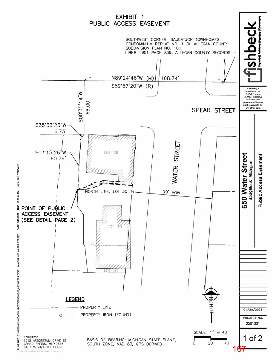
Text of page 167
�1 u-
EXHIBIT 1 PUBLIC ACCESS EASEMENT
GJ
SOUTHWEST CORNER, SAUGATUCK TOWNHOMES CONDOMINIUM REPLAT NO. 1 OF ALLEGAN COUNlY SUBDIVISION PLAN NO. 101, LIBER 1951 PAGE 839, ALLEGAN COUNlY RECORDS
N89.24'46"W
..of .cu,J
168.74'
ss9·57•2o"w (R)
Hard copy is intended to be 8.5•x1 when plotted. Scale(s) indicated and s;,aphic quality may not be accurate for any other size.
,q- . .- 0 0 I()
SPEAR STREET
c.o
b c.o s35·33•23"w 6.73'
ti w
so3·1s•25•w 60.79'
Q) Q) C '- cu
Cl)�
co g
NORTH LINE, LOT 30
3: i 0�
99' RO W
Lt)
� POINT OF PU UC � ACCESS EASE� ENT I (SEE DETAIL AGE 2) �
Q) ti)
ti) ti) Q) CJ CJ CJ .Q
LEGEND
--- PROPERlY LINE 0
01/29/2026
PROPERlY IRON (FOUND)
PROJECT NO,
2501331
BASIS OF BEARING: MICHIGAN STATE PLANE, SOUTH ZONE, NAO 83, GPS DERIVED
SCALE: 1"
' 40
1 of 2
Page 168
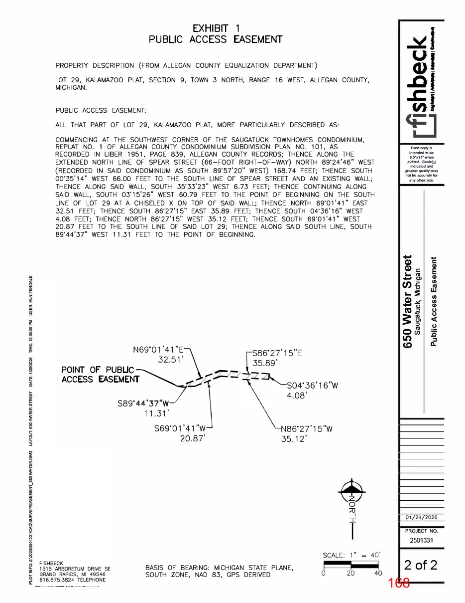
Text of page 168
�1 u-
EXHIBIT 1 PUBLIC ACCESS EASEMENT
GJ
PROPERTY DESCRIPTION (FROM ALLEGAN COUNTY EQUALIZATION DEPARTMENT)
..of .cu,J
LOT 29, KALAMAZOO PLAT, SECTION 9, TOWN 3 NORTH, RANGE 16 WEST, ALLEGAN COUNTY, MICHIGAN. PUBLIC ACCESS EASEMENT: ALL THAT PART OF LOT 29, KALAMAZOO PLAT, MORE PARTICULARLY DESCRIBED AS: COMMENCING AT THE SOUTHWEST CORNER OF THE SAUGATUCK TOWNHOMES CONDOMINIUM, REPLAT NO. 1 OF ALLEGAN COUNTY CONDOMINIUM SUBDIVISION PLAN NO. 101, AS RECORDED IN LIBER 1951, PAGE 839, ALLEGAN COUNTY RECORDS; THENCE ALONG THE EXTENDED NORTH LINE OF SPEAR STREET (66-FOOT RIGHT-OF-WAY) NORTH 89.24' 46" WEST (RECORDED IN SAID CONDOMINIUM AS SOUTH 89.57'20" WEST) 168.74 FEET; THENCE SOUTH 00-35'14" WEST 66.00 FEET TO THE SOUTH LINE OF SPEAR STREET AND AN EXISTING WALL; THENCE ALONG SAID WALL, SOUTH 35'33'23" WEST 6.73 FEET; THENCE CONTINUING ALONG SAID WALL, SOUTH 03'15'26" WEST 60.79 FEET TO THE POINT OF BEGINNING ON THE SOUTH LINE OF LOT 29 AT A CHISELED X ON TOP OF SAID WALL; THENCE NORTH 59·01'41" EAST 32.51 FEET; THENCE SOUTH 86.27'15" EAST 35.89 FEET; THENCE SOUTH 04'36'16" WEST 4.08 FEET; THENCE NORTH 86.27'15" WEST 35.12 FEET; THENCE SOUTH 69"01'41" WEST 20.87 FEET TO THE SOUTH LINE OF SAID LOT 29; THENCE ALONG SAID SOUTH LINE, SOUTH 89.44'37" WEST 11.31 FEET TO THE POINT OF BEGINNING.
<E] Hard copy is intended to be 8.5•x1 when plotted. Scale(s) indicated and s;,aphic quality may not be accurate for any other size.
Q) Q) C '- cu
Cl)�
Q) ti)
'- � wti) Q)
co g
3: i 0� Lt)
N69.01'41"E 32.51'
POINT OF PUBLIC�\
ACCESS EASEMENT
S86'27'15"E 35.89'
ti) Q) CJ CJ CJ
%� :Z�S04.36'16"W .z::..,.....
s89·44'37"w 11.31' S69.01'41"W 20.87'
4.08'
N86.27'15"W 35.12'
01/29/2026 PROJECT NO,
2501331
BASIS OF BEARING: MICHIGAN STATE PLANE, SOUTH ZONE, NAD 83, GPS DERIVED
SCALE: 1"
40'
2 of 2
Page 169
Text of page 169
PU B LI C WATERFRONT ACCESS