
Planning Agenda item 5B
Comprehensive (Master) Plan Chapters 1-3 Draft Review & Discussion
Planning Commission, Thursday, July 16, 2026
Download these 71 pages, 4.7 MB Whole packet, 84 pages, 5.4 MB
Page 14
Text of page 14
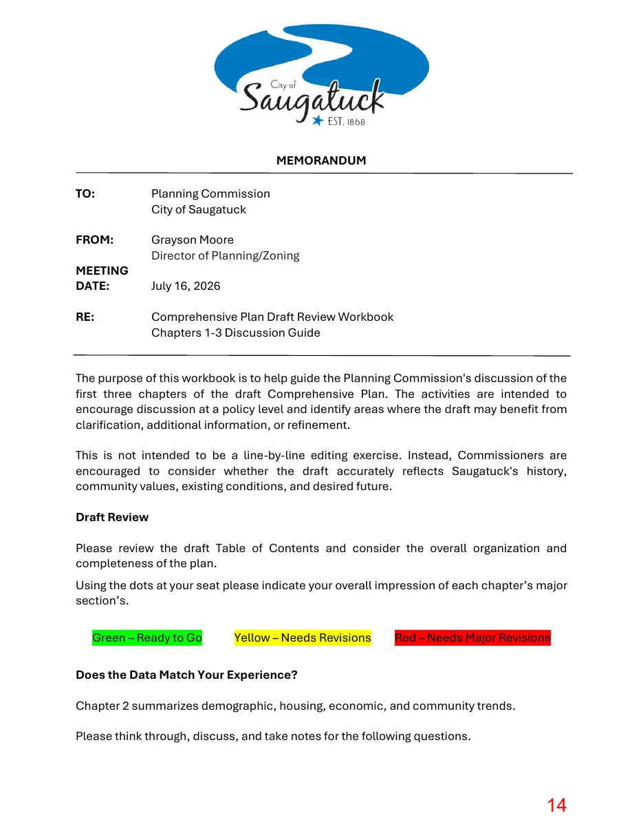
MEMORANDUM TO:
Planning Commission City of Saugatuck
FROM:
Grayson Moore Director of Planning/Zoning
MEETING DATE: RE:
July 16, 2026 Comprehensive Plan Draft Review Workbook Chapters 1-3 Discussion Guide
The purpose of this workbook is to help guide the Planning Commission's discussion of the first three chapters of the draft Comprehensive Plan. The activities are intended to encourage discussion at a policy level and identify areas where the draft may benefit from clarification, additional information, or refinement. This is not intended to be a line-by-line editing exercise. Instead, Commissioners are encouraged to consider whether the draft accurately reflects Saugatuck's history, community values, existing conditions, and desired future. Draft Review Please review the draft Table of Contents and consider the overall organization and completeness of the plan. Using the dots at your seat please indicate your overall impression of each chapter’s major section’s. Green – Ready to Go
Yellow – Needs Revisions
Red – Needs Major Revisions
Does the Data Match Your Experience? Chapter 2 summarizes demographic, housing, economic, and community trends. Please think through, discuss, and take notes for the following questions.
Page 15
Text of page 15
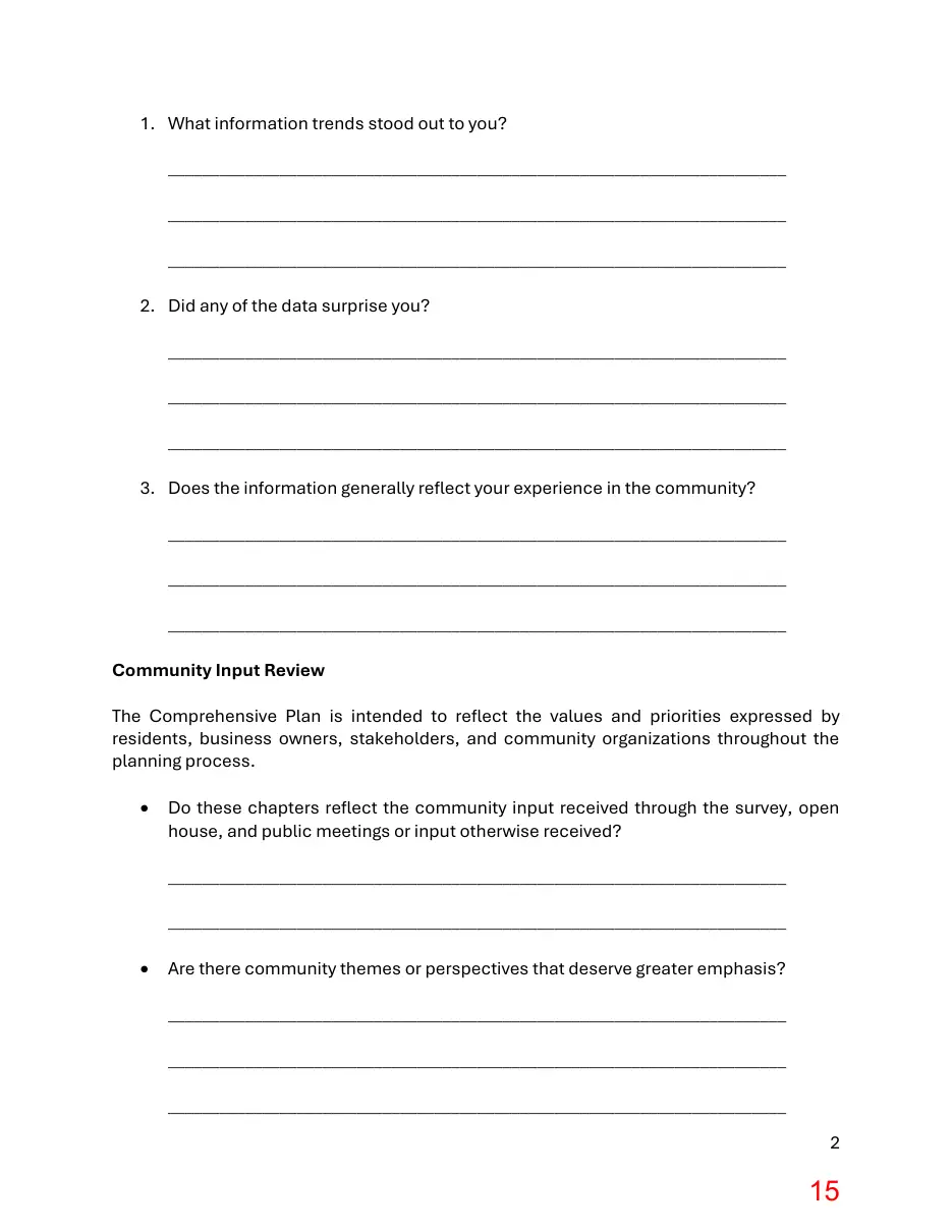
1. What information trends stood out to you? ________________________________________________________________________ ________________________________________________________________________ ________________________________________________________________________ 2. Did any of the data surprise you? ________________________________________________________________________ ________________________________________________________________________ ________________________________________________________________________ 3. Does the information generally reflect your experience in the community? ________________________________________________________________________ ________________________________________________________________________ ________________________________________________________________________ Community Input Review The Comprehensive Plan is intended to reflect the values and priorities expressed by residents, business owners, stakeholders, and community organizations throughout the planning process. •
Do these chapters reflect the community input received through the survey, open house, and public meetings or input otherwise received? ________________________________________________________________________ ________________________________________________________________________
Are there community themes or perspectives that deserve greater emphasis? ________________________________________________________________________ ________________________________________________________________________ ________________________________________________________________________ 2
Page 16
Text of page 16
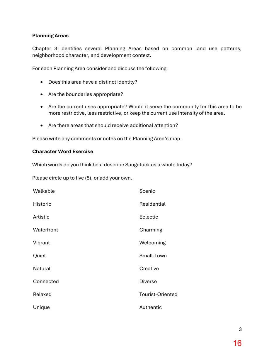
Planning Areas Chapter 3 identifies several Planning Areas based on common land use patterns, neighborhood character, and development context. For each Planning Area consider and discuss the following: •
Does this area have a distinct identity?
Are the boundaries appropriate?
Are the current uses appropriate? Would it serve the community for this area to be more restrictive, less restrictive, or keep the current use intensity of the area.
Are there areas that should receive additional attention?
Please write any comments or notes on the Planning Area’s map. Character Word Exercise Which words do you think best describe Saugatuck as a whole today? Please circle up to five (5), or add your own. Walkable
Scenic
Historic
Residential
Artistic
Eclectic
Waterfront
Charming
Vibrant
Welcoming
Quiet
Small-Town
Natural
Creative
Connected
Diverse
Relaxed
Tourist-Oriented
Unique
Authentic
Page 17
Text of page 17
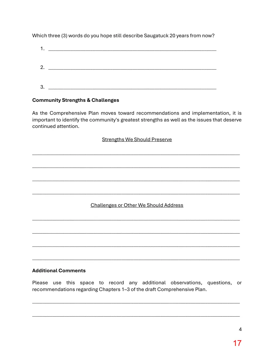
Which three (3) words do you hope still describe Saugatuck 20 years from now? 1. ____________________________________________________________________ 2. ____________________________________________________________________ 3. ____________________________________________________________________ Community Strengths & Challenges As the Comprehensive Plan moves toward recommendations and implementation, it is important to identify the community's greatest strengths as well as the issues that deserve continued attention. Strengths We Should Preserve ____________________________________________________________________________________ ____________________________________________________________________________________ ____________________________________________________________________________________ ____________________________________________________________________________________ Challenges or Other We Should Address ____________________________________________________________________________________ ____________________________________________________________________________________ ____________________________________________________________________________________ ____________________________________________________________________________________ Additional Comments Please use this space to record any additional observations, questions, or recommendations regarding Chapters 1–3 of the draft Comprehensive Plan. ____________________________________________________________________________________ ____________________________________________________________________________________ 4
Page 18
Text of page 18
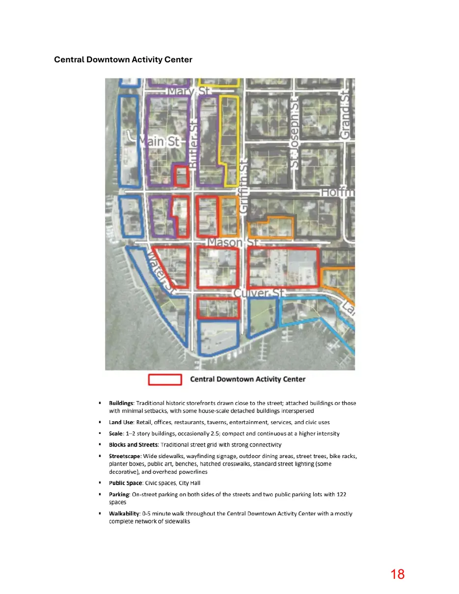
Central Downtown Activity Center
Page 19
Text of page 19
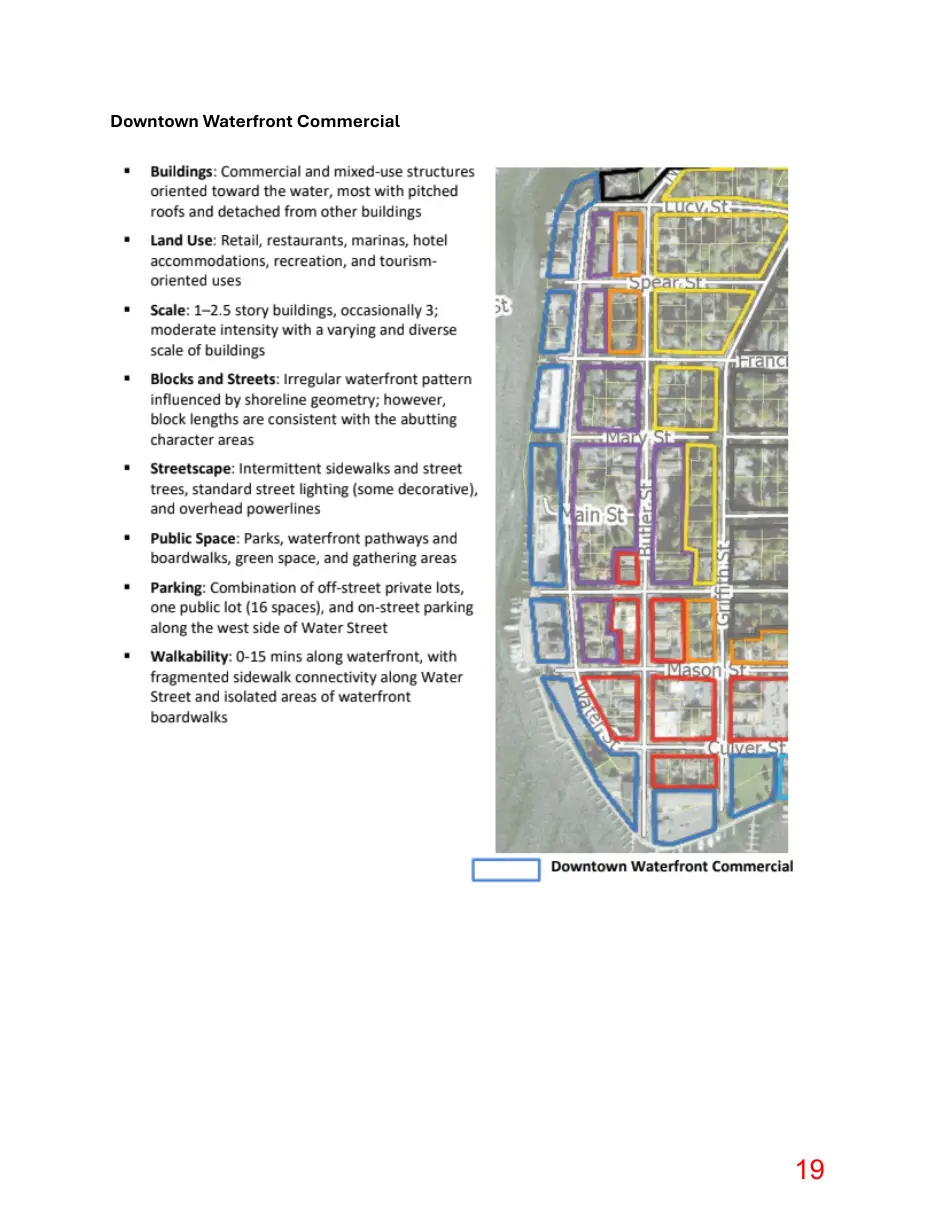
Downtown Waterfront Commercial
Page 20
Text of page 20
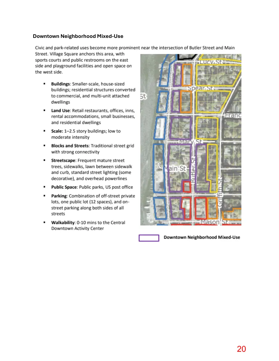
Downtown Neighborhood Mixed-Use
Page 21
Text of page 21
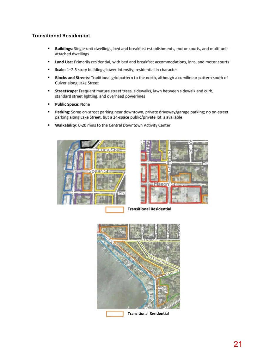
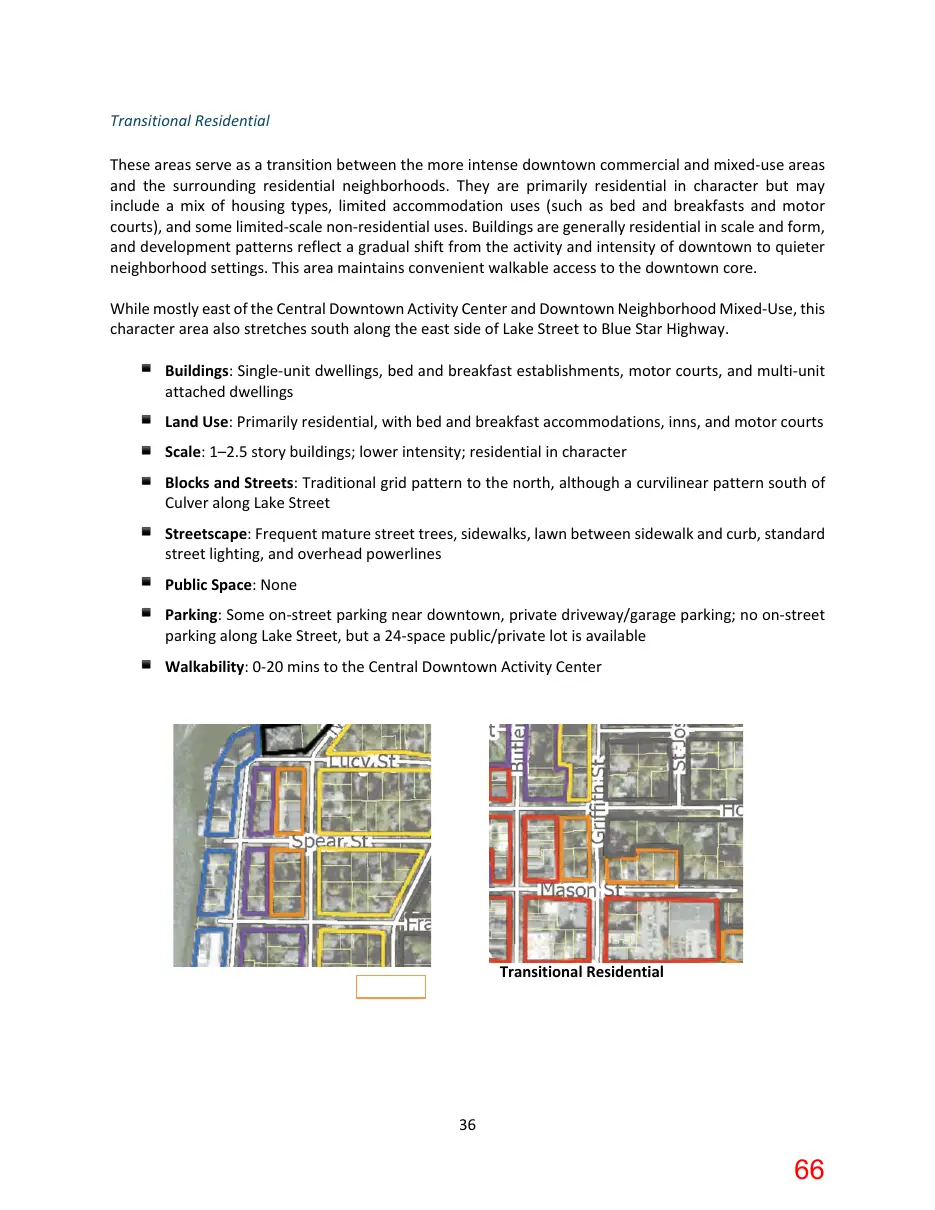
Transitional Residential
Page 22
Text of page 22
Central City Residential
Page 23
Text of page 23
Traditional Neighborhood Residential
Page 24
Text of page 24
North Riverfront Residential
Page 25
Text of page 25
South Riverfront Residential
Page 26
Text of page 26
North Marina/Harbor Services Area
Page 27
Text of page 27
South Hillside Residential
Page 28
Text of page 28
Suburban/Rural Fringe Residential
Page 29
Text of page 29
West Riverfront Residential
Page 30
Text of page 30
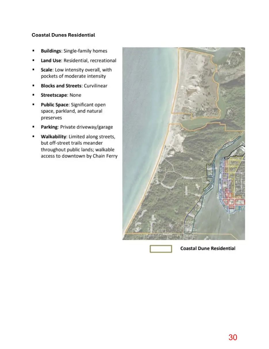
Coastal Dunes Residential
Page 31
Text of page 31
City of Saugatuck 2026 Comprehensive Plan Update
Working Draft File
Page 32
Text of page 32
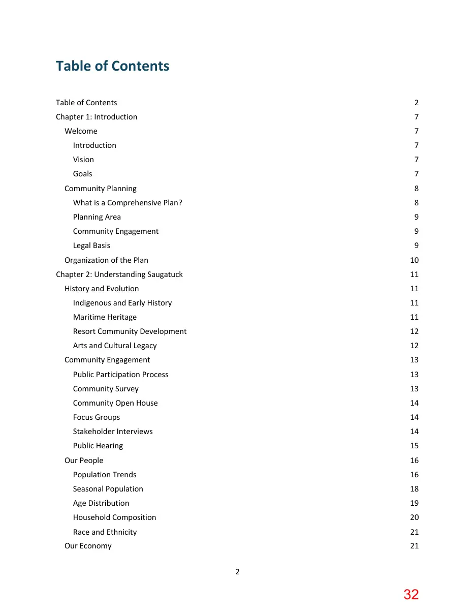
Table of Contents Table of Contents
Chapter 1: Introduction
Welcome
Introduction
Vision
Goals
Community Planning
What is a Comprehensive Plan?
Planning Area
Community Engagement
Legal Basis
Organization of the Plan
Chapter 2: Understanding Saugatuck
History and Evolution
Indigenous and Early History
Maritime Heritage
Resort Community Development
Arts and Cultural Legacy
Community Engagement
Public Participation Process
Community Survey
Community Open House
Focus Groups
Stakeholder Interviews
Public Hearing
Our People
Population Trends
Seasonal Population
Age Distribution
Household Composition
Race and Ethnicity
Our Economy
21 2
Page 33
Text of page 33
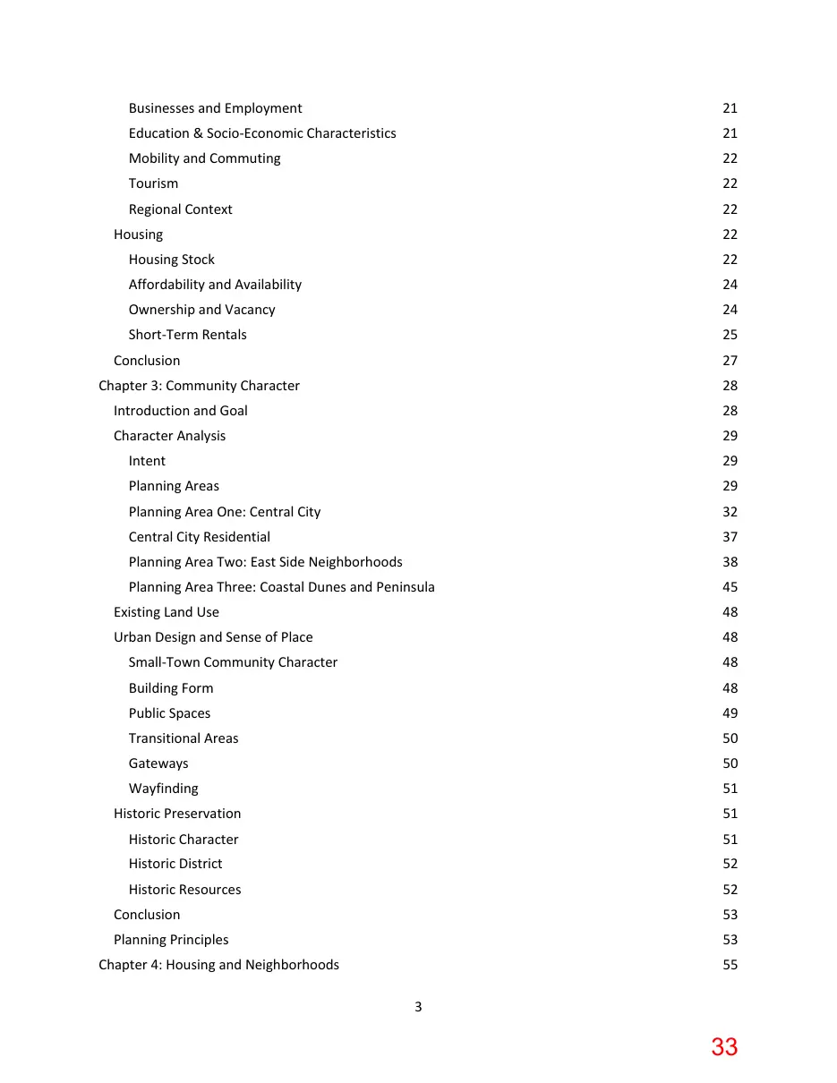
Businesses and Employment
Education & Socio-Economic Characteristics
Mobility and Commuting
Tourism
Regional Context
Housing
Housing Stock
Affordability and Availability
Ownership and Vacancy
Short-Term Rentals
Conclusion
Chapter 3: Community Character
Introduction and Goal
Character Analysis
Intent
Planning Areas
Planning Area One: Central City
Central City Residential
Planning Area Two: East Side Neighborhoods
Planning Area Three: Coastal Dunes and Peninsula
Existing Land Use
Urban Design and Sense of Place
Small-Town Community Character
Building Form
Public Spaces
Transitional Areas
Gateways
Wayfinding
Historic Preservation
Historic Character
Historic District
Historic Resources
Conclusion
Planning Principles
Chapter 4: Housing and Neighborhoods
55 3
Page 34
Text of page 34
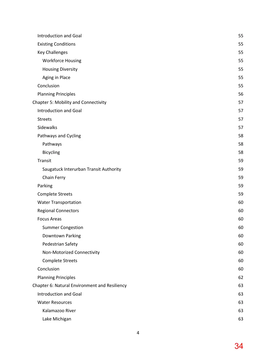
Introduction and Goal
Existing Conditions
Key Challenges
Workforce Housing
Housing Diversity
Aging in Place
Conclusion
Planning Principles
Chapter 5: Mobility and Connectivity
Introduction and Goal
Streets
Sidewalks
Pathways and Cycling
Pathways
Bicycling
Transit
Saugatuck Interurban Transit Authority
Chain Ferry
Parking
Complete Streets
Water Transportation
Regional Connectors
Focus Areas
Summer Congestion
Downtown Parking
Pedestrian Safety
Non-Motorized Connectivity
Complete Streets
Conclusion
Planning Principles
Chapter 6: Natural Environment and Resiliency
Introduction and Goal
Water Resources
Kalamazoo River
Lake Michigan
63 4
Page 35
Text of page 35
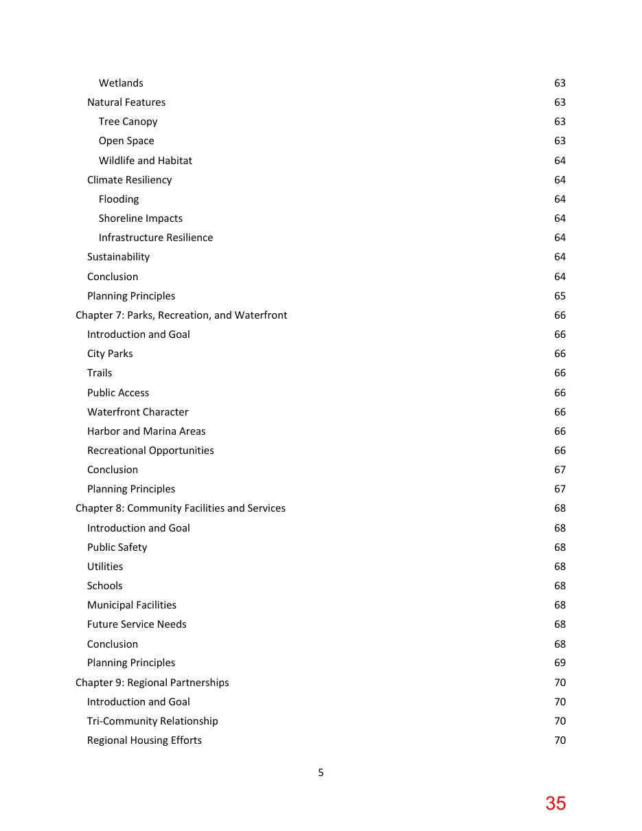
Wetlands
Natural Features
Tree Canopy
Open Space
Wildlife and Habitat
Climate Resiliency
Flooding
Shoreline Impacts
Infrastructure Resilience
Sustainability
Conclusion
Planning Principles
Chapter 7: Parks, Recreation, and Waterfront
Introduction and Goal
City Parks
Trails
Public Access
Waterfront Character
Harbor and Marina Areas
Recreational Opportunities
Conclusion
Planning Principles
Chapter 8: Community Facilities and Services
Introduction and Goal
Public Safety
Utilities
Schools
Municipal Facilities
Future Service Needs
Conclusion
Planning Principles
Chapter 9: Regional Partnerships
Introduction and Goal
Tri-Community Relationship
Regional Housing Efforts
70 5
Page 36
Text of page 36
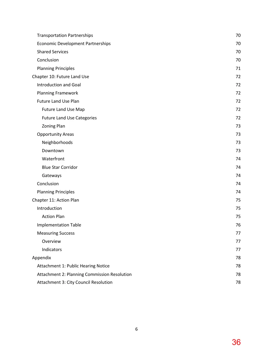
Transportation Partnerships
Economic Development Partnerships
Shared Services
Conclusion
Planning Principles
Chapter 10: Future Land Use
Introduction and Goal
Planning Framework
Future Land Use Plan
Future Land Use Map
Future Land Use Categories
Zoning Plan
Opportunity Areas
Neighborhoods
Downtown
Waterfront
Blue Star Corridor
Gateways
Conclusion
Planning Principles
Chapter 11: Action Plan
Introduction
Action Plan
Implementation Table
Measuring Success
Overview
Indicators
Appendix
Attachment 1: Public Hearing Notice
Attachment 2: Planning Commission Resolution
Attachment 3: City Council Resolution
Page 37
Text of page 37
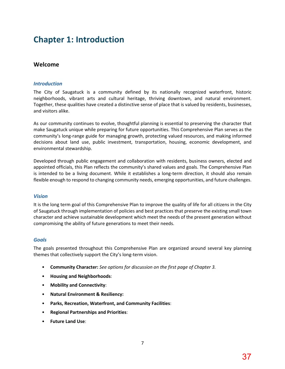
Chapter 1: Introduction Welcome Introduction The City of Saugatuck is a community defined by its nationally recognized waterfront, historic neighborhoods, vibrant arts and cultural heritage, thriving downtown, and natural environment. Together, these qualities have created a distinctive sense of place that is valued by residents, businesses, and visitors alike. As our community continues to evolve, thoughtful planning is essential to preserving the character that make Saugatuck unique while preparing for future opportunities. This Comprehensive Plan serves as the community’s long-range guide for managing growth, protecting valued resources, and making informed decisions about land use, public investment, transportation, housing, economic development, and environmental stewardship. Developed through public engagement and collaboration with residents, business owners, elected and appointed officials, this Plan reflects the community’s shared values and goals. The Comprehensive Plan is intended to be a living document. While it establishes a long-term direction, it should also remain flexible enough to respond to changing community needs, emerging opportunities, and future challenges.
Vision It is the long term goal of this Comprehensive Plan to improve the quality of life for all citizens in the City of Saugatuck through implementation of policies and best practices that preserve the existing small town character and achieve sustainable development which meet the needs of the present generation without compromising the ability of future generations to meet their needs.
Goals The goals presented throughout this Comprehensive Plan are organized around several key planning themes that collectively support the City’s long-term vision. •
Community Character: See options for discussion on the first page of Chapter 3.
Housing and Neighborhoods:
Mobility and Connectivity:
Natural Environment & Resiliency:
Parks, Recreation, Waterfront, and Community Facilities:
Regional Partnerships and Priorities:
Future Land Use:
Page 38
Text of page 38
Community Planning What is a Comprehensive Plan? A Comprehensive Plan is a long-range policy document that guides how a community will grow, develop, and change over time. The Plan brings together community values, public input, technical analysis, and data to establish a vision for the future. It identifies goals, policies, and recommendations that guide decisions related to land use, housing, transportation, infrastructure, parks, natural resources, economic development, and community character. Unlike the Zoning Ordinance, the Comprehensive Plan does not regulate individual properties. Instead, it provides the policy framework that guides future zoning decisions, capital improvements, public investments, and community development initiatives. Together, these implementation tools help ensure that future decisions remain consistent with the community's vision. This Comprehensive Plan is intended to be used as a practical decision-making tool by City officials, residents, property owners, developers, and community partners. The Plan is organized to guide users through a logical planning process: ● ● ● ● ●
Vision - Begin with the community vision and guiding principles that establish the overall direction for Saugatuck's future. Topics - Review individual chapters for detailed goals, policies, and recommendations related to specific planning topics. Future Land Use - Reference the Future Land Use Map to understand the City's long-term development pattern and planning objectives. Decision Making - Use the Plan to evaluate development proposals, zoning requests, public investments, capital improvement projects, and policy decisions. Implementation - Recognize that the Comprehensive Plan is a living document intended to guide ongoing decision-making while adapting to changing community needs through periodic review and updates.
The Comprehensive Plan is intended to serve a wide range of users throughout the community including: ●
City Council - Uses the Plan to establish policy direction, prioritize capital improvements and evaluate public investments. ○ Example: Determining whether to fund a new park, reconstruct a street, or expand public utilities. Planning Commission - Use the Plan when reviewing rezonings, site plans, special land uses, ordinance amendments, and long-range planning initiatives. ○ Example: Evaluating whether a proposed rezoning is consistent with the Future Land Use Map and the community's long-term vision. City Staff - Use the Plan to guide daily planning decisions, administer development regulations, and coordinate infrastructure improvements. ○ Example: Reviewing development proposals or preparing recommendations for elected and appointed officials. Property Owners - Use the Plan to better understand the City’s long-term vision for their neighborhood and nearby areas.
Page 39
Text of page 39
Example: Understanding how future public improvements or land use changes may affect their property. Developers and Business Owners - Use the Plan to understand the City’s expectations for future development and investment. ○ Example: Identifying areas appropriate for redevelopment or determining whether a proposed project aligns with community goals. Residents - Use the Plan to understand community priorities and participate in future planning decisions. ○ Example: Providing informed comments during public hearings or advocating for neighborhood improvements or changes. Regional Partners and Public Agencies - Use the Plan to coordinate projects and investments that extend beyond municipal boundaries. ○ Example: Collaborating on transportation improvements, environmental initiatives, utility planning, or regional trail connections. Community Organizations Uses the Plan to align programs, grant opportunities, and partnerships with community priorities. ○ Example: Pursuing funding for housing initiatives, public art, environmental stewardship, or recreational improvements.
Planning Area This Comprehensive Plan applies to all land within the municipal boundaries of the City of Saugatuck. Because planning extends beyond jurisdictional boundaries, the Plan also recognizes the City's longstanding partnerships with neighboring communities and regional organizations. Building upon the collaborative foundation established through previous Tri-Community planning efforts, this Plan acknowledges that issues such as transportation, housing, economic development, environmental stewardship, and recreation are best addressed through continued regional cooperation.
Community Engagement As part of the comprehensive planning process, the City conducted a community survey, hosted a community open house as a kickoff event, and provided opportunities for focus group discussions and stakeholder interviews. Together, these engagement efforts helped shape the overall vision, goals, and direction of the planning process. As this Comprehensive Plan is intended to reflect the community's vision for its future, public input served as a fundamental component in developing its recommendations and policies.
Legal Basis This Comprehensive Plan has been prepared under the authority of the Michigan Planning Enabling Act (Public Act 33 of 2008, as amended), which authorizes local governments to prepare and adopt long-range community plans to promote the public health, safety, and general welfare. The Act further requires that zoning ordinances be based upon an adopted plan. Accordingly, this Comprehensive Plan provides the policy foundation for future land use decisions, amendments to the Zoning Ordinance, capital improvement planning, and other community development initiatives. While 9
Page 40
Text of page 40
the Plan establishes the City's long-term vision and policy direction, the Zoning Ordinance serves as the regulatory tool used to implement that vision through specific development standards.
Organization of the Plan The Comprehensive Plan is organized into chapters that move from understanding the City today to outlining strategies for the future. The early chapters describe existing conditions, community input, and the foundation for planning. Later chapters establish goals, principles, and actions, along with a land use strategy and an implementation program. •
Chapter Two: Understanding Saugatuck: Provides an overview of the City’s existing conditions, demographics, and community engagement opportunities.
Chapter Three: Community Character: Analyze community characteristics, including existing land uses, urban design, historic preservation, and planning principles.
Chapter Four: Housing and Neighborhoods: Addressing housing conditions, neighborhood preservation, existing housing diversity, and future residential opportunities.
Chapter Five: Mobility and Connectivity: Evaluation of streets, sidewalks, bicycle facilities, public transit, parking, and opportunities to improve transportation.
Chapter Six: Natural Environment and Resiliency: Explores Saugatuck's natural resources, including its waterways, dunes, wetlands, woodlands, and other defining natural features. The chapter establishes strategies for environmental stewardship, climate resilience, shoreline planning, and the long-term protection of the City's ecological assets.
Chapter Seven: Parks, Waterfront, and Community Facilities: Examine the City’s parks, trails, waterfront access, recreational amenities, public spaces, municipal facilities, infrastructure, utilities, and public services. The chapter identifies opportunities to enhance community assets while ensuring public facilities continue to support residents, businesses, and visitors.
Chapter Eight: Regional Partnerships and Priorities: Highlights collaboration with neighboring communities and regional organizations on transportation, housing, environmental protection, tourism, economic development, and other shared initiatives.
Chapter Nine: Future Land Use: Establishes the Future Land Use Map and supporting policies that guide future growth, redevelopment, preservation, and land use decisions.
Chapter Ten: Action Plan: Identifies implementation strategies, priorities, responsible parties, and tools needed to achieve the vision and goals of the Comprehensive Plan.
Page 41
Text of page 41
Chapter 2: Understanding Saugatuck History and Evolution Indigenous and Early History Prior to European-American settlement, the Saugatuck area was part of the homeland and seasonal use territory of the Ottawa (Odawa) and Potawatomi peoples. These Indigenous communities maintained a close relationship with the region’s rivers, lakes, forests, and dunes using the landscape for seasonal settlement, fishing, hunting, and trade. Archaeological and historical evidence indicates that the broader Lake Michigan shoreline supported long-standing Indigenous use patterns well before the 19th century. European-American fur traders began to move through the region in the early 1800s, followed by permanent settlement in the 1830s. One of the earliest recorded settlers was William Butler, who arrived around 1830 and is associated with early land claims and development activity near the mouth of the Kalamazoo River. As settlement expanded, a small village began to take shape in proximity to the river outlet. The name “Saugatuck” is widely understood to derive from a Potawatomi word generally interpreted as “mouth of the river” or “outlet of the river,” reflecting the community’s geographic relationship to the Kalamazoo River and Lake Michigan.
Maritime Heritage Saugatuck’s early growth was closely tied to its location at the mouth of the Kalamazoo River and its access to Lake Michigan. The river served as an important transportation corridor for moving timber and other goods between inland areas and regional Great Lakes markets. During the mid-19th century, the local economy developed around lumbering and related industries, including sawmills, barrel-making, and other wood-product manufacturing. Timber harvested from surrounding forests was transported via the river to Lake Michigan, contributing to regional development during a period of rapid growth in western Michigan. While Saugatuck participated in broader Great Lakes maritime trade, including vessel activity and shipping-related industries, its scale was typical of a small river port community rather than a major shipbuilding center. Water transportation, including ferry crossings of the Kalamazoo River, remained an important part of daily life and connectivity between the developing communities on either side of the river. As local timber resources were depleted by the late 19th century, the maritime economy gradually transitioned away from extraction-based shipping toward tourism and recreational uses of the waterfront.
Page 42
Text of page 42
Resort Community Development By the late 19th century, Saugatuck began transitioning from a resource-based economy to a seasonal resort and recreational destination. As the lumber industry declined, the community’s scenic setting along Lake Michigan, the Kalamazoo River, and surrounding dune landscapes increasingly attracted visitors seeking leisure and retreat. A cottage and resort culture emerged during this period, supported by steamboat and rail connections in the broader region. Saugatuck developed as a small but active destination for seasonal residents and visitors from nearby urban centers, particularly Chicago and western Michigan communities. Unlike many rapidly industrializing Great Lakes cities, Saugatuck retained a relatively intact historic building fabric, which today contributes to its recognized architectural diversity. The community includes examples of Greek Revival, Italianate, Arts and Crafts, and Colonial Revival architecture, reflecting multiple eras of development. Over time, the community developed an intentional approach to historic preservation, including the establishment of historic district protections and collaboration with local historical organizations. These efforts have helped maintain the character of the downtown and surrounding residential areas while supporting tourism as a continuing economic driver.
Arts and Cultural Legacy In the early 20th century, Saugatuck emerged as an artist destination, building on its natural setting and growing reputation as a quiet retreat from urban life. Artists from Chicago and other Midwestern cities were drawn to the area’s landscapes and seasonal atmosphere. A key milestone in this development was the founding of the Ox-Bow School of Art in 1910 as an extension of the School of the Art Institute of Chicago. Located on Ox-Bow Lagoon, the school became an influential center for art education and helped establish Saugatuck as a recognized creative community. Throughout the 20th century, the arts played an increasingly important role in shaping the local economy and identity. Galleries, studios, and cultural institutions expanded, contributing to what is now commonly referred to as the “Art Coast of Michigan.” In the midto late-20th century, Saugatuck also became known as a welcoming destination for LGBTQ+ visitors and residents. This identity evolved over time and contributed to the community’s broader reputation for inclusivity and cultural openness. Today, arts and culture remain central to Saugatuck’s identity, reinforcing its role as a regional destination and shaping both community character and economic activity.
Page 43
Text of page 43
Community Engagement Public Participation Process Public engagement was a central component of the comprehensive planning process and helped ensure that the plan reflects the community's vision for the future. The following section summarizes the outreach efforts undertaken and the public input that informed the goals, policies, and recommendations of this Comprehensive Plan.
Community Survey The City of Saugatuck conducted a community-wide survey from August through early October 2025 to gather input that would help shape the Comprehensive Plan. A total of 386 individuals participated, including full-time and seasonal residents, business owners, property owners, and other community stakeholders. The survey provided valuable insight into the community's strengths, challenges, and priorities for the future. Overall, respondents expressed strong appreciation for the qualities that make Saugatuck unique. The City's small-town character, walkable downtown, vibrant arts and cultural community, locally owned businesses, and access to the Kalamazoo River and Lake Michigan were consistently identified as defining features that should be preserved. Participants also expressed broad support for thoughtful investment in the City's future. Improving sidewalks, crosswalks, multi-use pathways, and bicycle facilities emerged as one of the strongest priorities, along with preserving neighborhood character, protecting the tree canopy and natural environment, and maintaining a vibrant downtown that continues to serve residents and visitors alike. Many respondents also supported strategies that strengthen the year-round economy while respecting the City's historic scale and community character. Survey participants emphasized the importance of environmental stewardship and resiliency, improved pedestrian connectivity, and continued support for local businesses and public infrastructure. These recurring themes directly informed the goals, policies, and recommendations presented throughout this Comprehensive Plan. Survey Highlights ● ● ● ● ● ●
386 total survey responses 222 respondents identified as City residents 80% of resident respondents live in single-family detached homes 87% supported preserving existing neighborhood character 92% agreed that preserving and expanding the City's tree canopy should remain a priority 57% supported exploring the creation of a Downtown Development Authority to help fund public improvements
Top Community Priorities 13
Page 44
Text of page 44
1. 2. 3. 4.
Maintain a vibrant downtown while preserving Saugatuck's small-town character. Foster a welcoming and inclusive community. Improve sidewalks, crosswalks, pathways, and bicycle connectivity. Protect natural resources through environmental sustainability and resiliency.
The survey findings established an important foundation for the Comprehensive Plan by confirming that residents value thoughtful stewardship over significant change. The community's vision focuses on preserving Saugatuck's distinctive character while making strategic investments that enhance walkability, environmental quality, public infrastructure, and the overall quality of life.
Community Open House The first community open house was held on September 30, 2025, as an early step in the comprehensive planning process to gather input from residents and stakeholders regarding community values, priorities, and the future of Saugatuck. Approximately 28 participants attended and participated in a series of interactive activities, including mapping exercises, voting activities, and written comment boards. Overall, participants emphasized preserving Saugatuck's small-town character, waterfront, natural resources, and arts community while improving walkability, public spaces, waterfront access, year-round livability, and downtown amenities, with limited support for significant physical change outside of a few targeted areas.
Focus Groups Insert summary if/when this occurs.
Stakeholder Interviews As part of the Comprehensive Plan process, the City conducted stakeholder interviews to gather perspectives from individuals and organizations with unique knowledge and experience within the community. These conversations provided an opportunity to explore specific topics in greater depth than was possible through the community survey or public open house. Stakeholder interviews were intended to complement broader public engagement by identifying community strengths, challenges, and opportunities from the perspective of those who regularly interact with Saugatuck's neighborhoods, businesses, public spaces, and transportation network. While each interview reflected the experiences of a particular group, many of the themes aligned closely with the broader community feedback received throughout the planning process. The following summarizes key themes identified during stakeholder interviews conducted as part of the Comprehensive Plan. Community Walking Group City staff met with members of a long-standing community walking group that has regularly explored Saugatuck on foot since 2006. The group includes approximately 90 members, with around 30 participants 14
Page 45
Text of page 45
routinely walking within the city each week. Their regular routes through downtown, neighborhoods, Oval Beach, and the Mount Baldhead area provide a unique perspective on pedestrian infrastructure and accessibility. Participants consistently emphasized the importance of maintaining and enhancing Saugatuck's walkability. While they expressed appreciation for recent sidewalk improvements, including the Maple Street project, and recognized the City's commitment to winter sidewalk maintenance, they also identified opportunities to improve pedestrian safety and accessibility throughout the community. Key discussion topics included improving pedestrian crossings at major intersections, repairing uneven sidewalks, filling sidewalk gaps, expanding pedestrian connectivity, and exploring opportunities to extend the boardwalk system. Participants also discussed the growing interaction between pedestrians and electric bicycles, suggesting that additional bicycle infrastructure, wider sidewalks where feasible, rider education, and clearer expectations for shared-use areas could improve safety for all users. One location receiving particular attention was the intersection of Holland Street and Blue Star Highway, where participants described challenges crossing the roadway safely and suggested that future intersection improvements should prioritize pedestrian safety. Overall, the interview reinforced a community-wide desire to continue investing in safe, accessible, and connected pedestrian infrastructure while balancing the needs of pedestrians, bicyclists, motorists, residents, and visitors. Key Takeaways ● ● ● ● ●
Improve pedestrian safety at key intersections, particularly Holland Street and Blue Star Highway. Continue investing in sidewalks, accessibility improvements, and routine maintenance. Expand pedestrian connectivity through additional sidewalks, pathways, and boardwalk connections. Improve the visibility and safety of pedestrian crossings throughout the city. Address interactions between pedestrians and e-bike users through infrastructure improvements, education, and operational strategies.
Public Hearing A public hearing was held on _______ to receive comments on the proposed Comprehensive Plan following completion of the 63-day notice and review period required by the Michigan Planning Enabling Act. The public hearing provided the official opportunity to review the proposed plan and submit comments prior to its adoption. Comments received during the public hearing and review period were considered by the Planning Commission before making its recommendation to the City Council regarding adoption of the Comprehensive Plan.
Page 46
Text of page 46
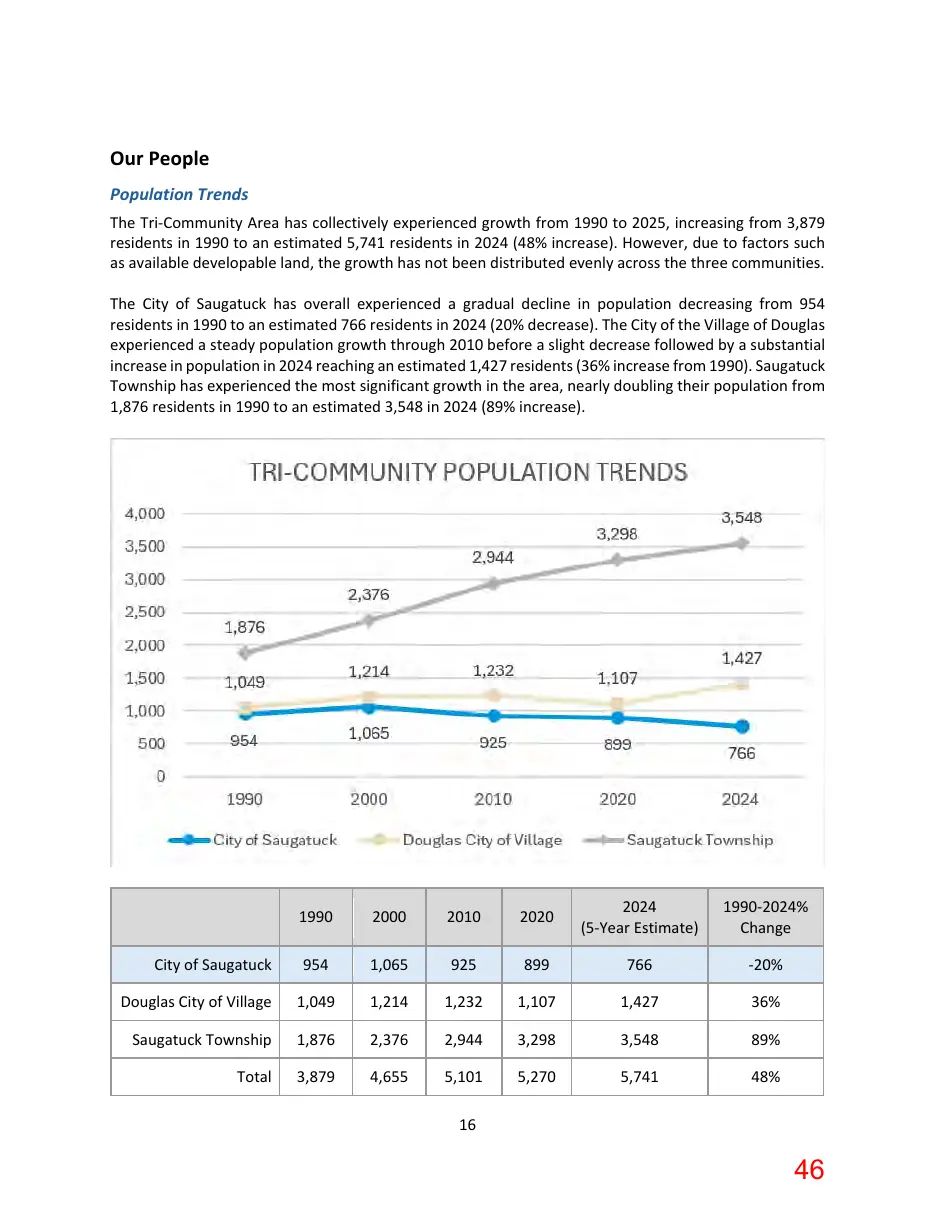
Our People Population Trends The Tri-Community Area has collectively experienced growth from 1990 to 2025, increasing from 3,879 residents in 1990 to an estimated 5,741 residents in 2024 (48% increase). However, due to factors such as available developable land, the growth has not been distributed evenly across the three communities. The City of Saugatuck has overall experienced a gradual decline in population decreasing from 954 residents in 1990 to an estimated 766 residents in 2024 (20% decrease). The City of the Village of Douglas experienced a steady population growth through 2010 before a slight decrease followed by a substantial increase in population in 2024 reaching an estimated 1,427 residents (36% increase from 1990). Saugatuck Township has experienced the most significant growth in the area, nearly doubling their population from 1,876 residents in 1990 to an estimated 3,548 in 2024 (89% increase).
1990
2000
2010
2020
2024 (5-Year Estimate)
1990-2024% Change
City of Saugatuck
1,065
-20%
Douglas City of Village
1,049
1,214
1,232
1,107
1,427
36%
Saugatuck Township
1,876
2,376
2,944
3,298
3,548
89%
Total
3,879
4,655
5,101
5,270
5,741
48%
Page 47
Text of page 47
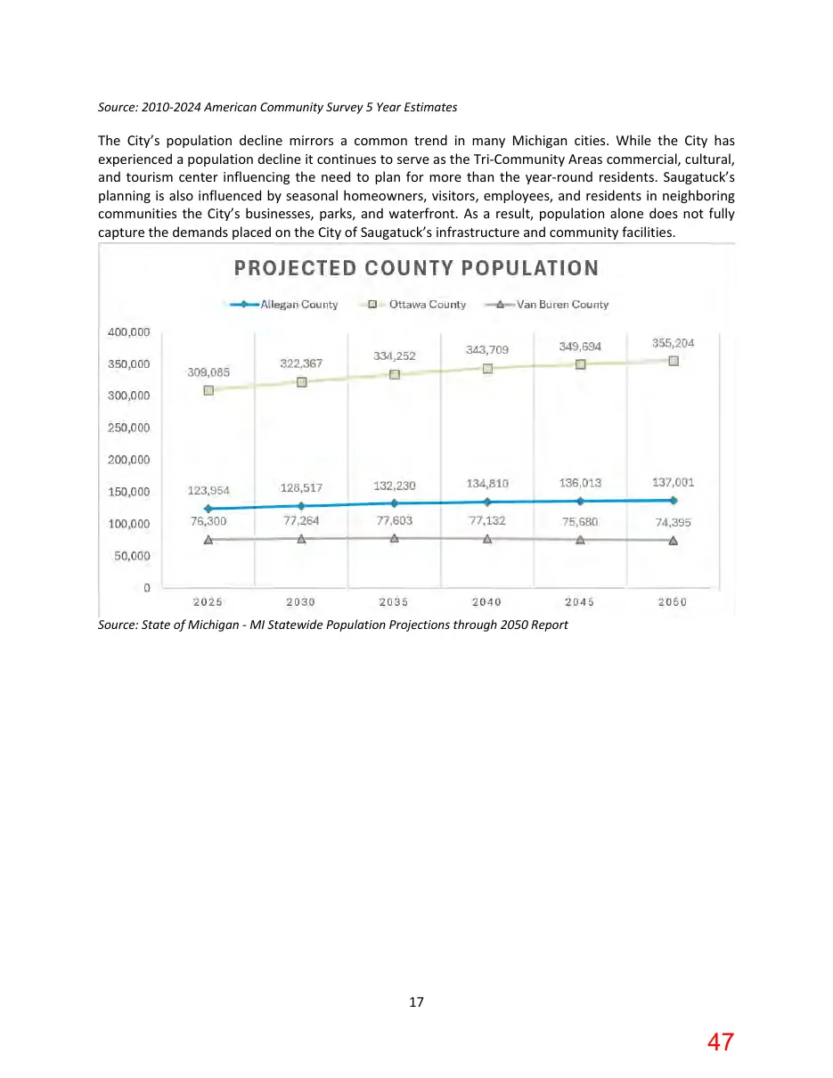
Source: 2010-2024 American Community Survey 5 Year Estimates
The City’s population decline mirrors a common trend in many Michigan cities. While the City has experienced a population decline it continues to serve as the Tri-Community Areas commercial, cultural, and tourism center influencing the need to plan for more than the year-round residents. Saugatuck’s planning is also influenced by seasonal homeowners, visitors, employees, and residents in neighboring communities the City’s businesses, parks, and waterfront. As a result, population alone does not fully capture the demands placed on the City of Saugatuck’s infrastructure and community facilities.
Source: State of Michigan - MI Statewide Population Projections through 2050 Report
Page 48
Text of page 48
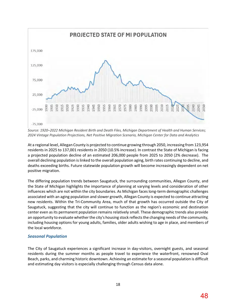
Source: 1920–2022 Michigan Resident Birth and Death Files, Michigan Department of Health and Human Services; 2024 Vintage Population Projections, Net Positive Migration Scenario, Michigan Center for Data and Analytics
At a regional level, Allegan County is projected to continue growing through 2050, increasing from 123,954 residents in 2025 to 137,001 residents in 2050 (10.5% increase). In contrast the State of Michigan is facing a projected population decline of an estimated 206,000 people from 2025 to 2050 (2% decrease). The overall declining population is linked to the overall population aging, birth rates continuing to decline, and deaths exceeding births. Future statewide population growth will become increasingly dependent on net positive migration. The differing population trends between Saugatuck, the surrounding communities, Allegan County, and the State of Michigan highlights the importance of planning at varying levels and consideration of other influences which are not within the city boundaries. As Michigan faces long-term demographic challenges associated with an aging population and slower growth, Allegan County is expected to continue attracting new residents. Within the Tri-Community Area, much of that growth has occurred outside the City of Saugatuck, suggesting that the city will continue to function as the region's economic and destination center even as its permanent population remains relatively small. These demographic trends also provide an opportunity to evaluate whether the city's housing stock reflects the changing needs of the community, including housing options for young adults, families, older adults wishing to age in place, and members of the local workforce.
Seasonal Population The City of Saugatuck experiences a significant increase in day-visitors, overnight guests, and seasonal residents during the summer months as people travel to experience the waterfront, renowned Oval Beach, parks, and charming historic downtown. Achieving an estimate for a seasonal population is difficult and estimating day visitors is especially challenging through Census data alone.
Page 49
Text of page 49
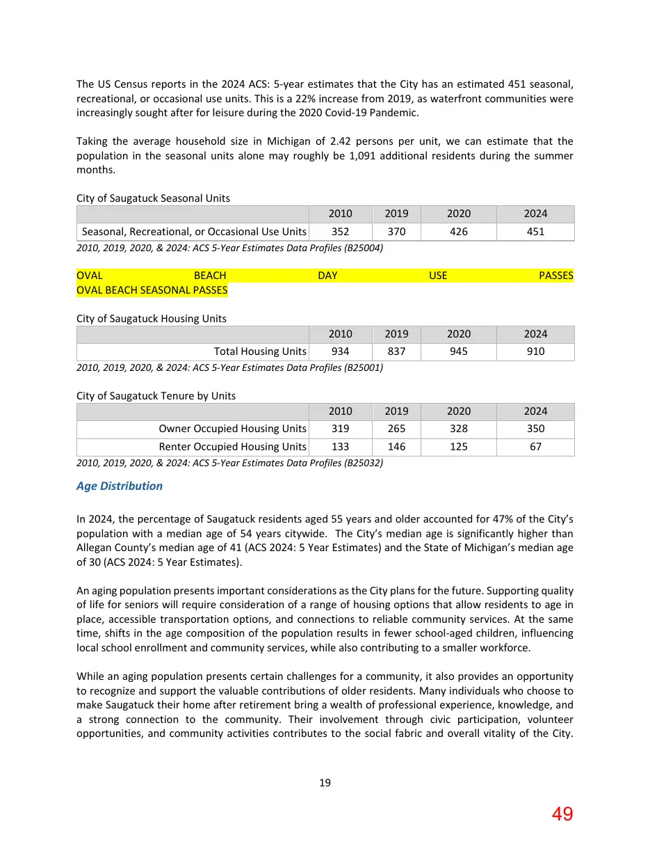
The US Census reports in the 2024 ACS: 5-year estimates that the City has an estimated 451 seasonal, recreational, or occasional use units. This is a 22% increase from 2019, as waterfront communities were increasingly sought after for leisure during the 2020 Covid-19 Pandemic. Taking the average household size in Michigan of 2.42 persons per unit, we can estimate that the population in the seasonal units alone may roughly be 1,091 additional residents during the summer months. City of Saugatuck Seasonal Units Seasonal, Recreational, or Occasional Use Units
2010 352
2019 370
2020 426
2024 451
2010, 2019, 2020, & 2024: ACS 5-Year Estimates Data Profiles (B25004)
OVAL BEACH OVAL BEACH SEASONAL PASSES
DAY
USE
PASSES
City of Saugatuck Housing Units Total Housing Units
2010 934
2019 837
2020 945
2024 910
2019 265 146
2020 328 125
2024 350 67
2010, 2019, 2020, & 2024: ACS 5-Year Estimates Data Profiles (B25001)
City of Saugatuck Tenure by Units Owner Occupied Housing Units Renter Occupied Housing Units
2010 319 133
2010, 2019, 2020, & 2024: ACS 5-Year Estimates Data Profiles (B25032)
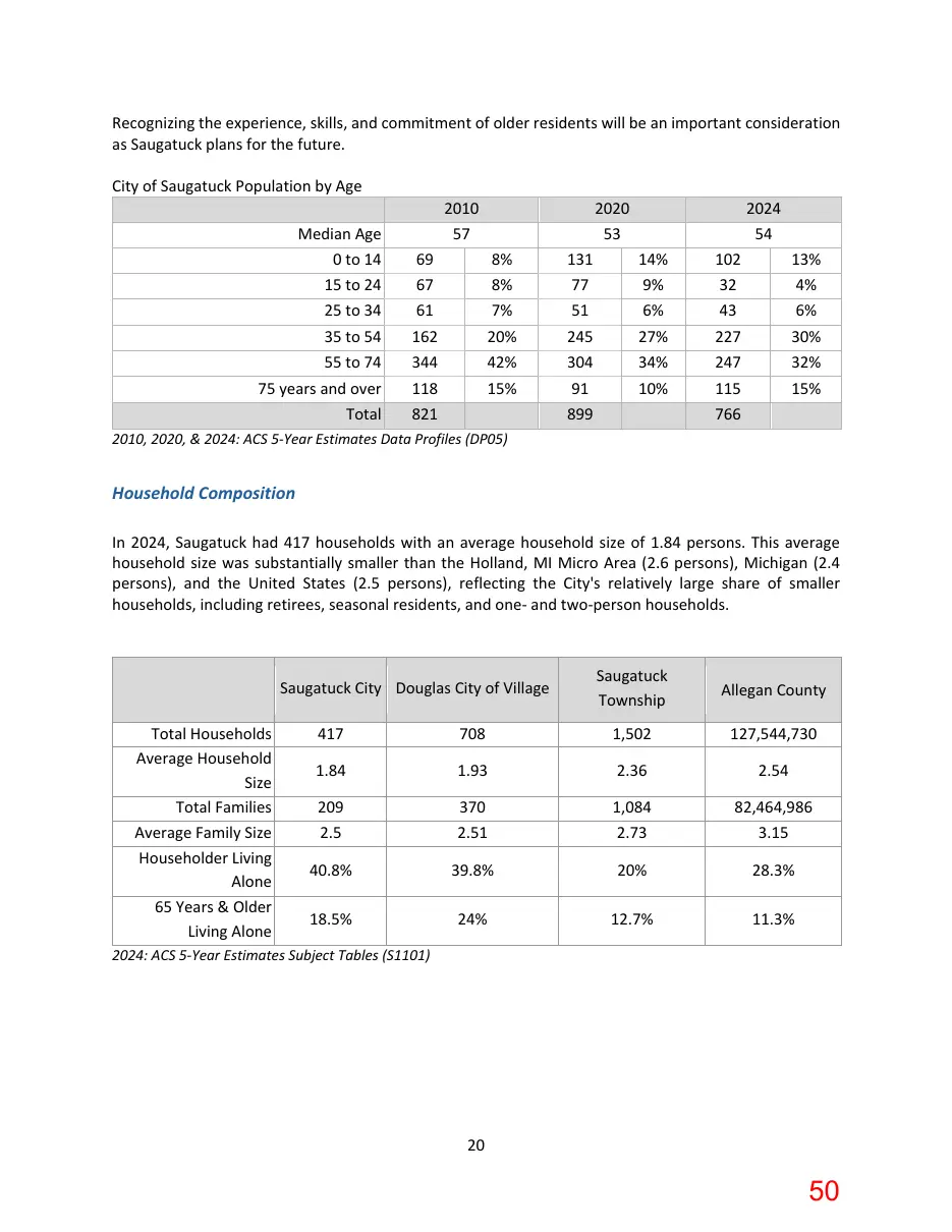
Age Distribution In 2024, the percentage of Saugatuck residents aged 55 years and older accounted for 47% of the City’s population with a median age of 54 years citywide. The City’s median age is significantly higher than Allegan County’s median age of 41 (ACS 2024: 5 Year Estimates) and the State of Michigan’s median age of 30 (ACS 2024: 5 Year Estimates). An aging population presents important considerations as the City plans for the future. Supporting quality of life for seniors will require consideration of a range of housing options that allow residents to age in place, accessible transportation options, and connections to reliable community services. At the same time, shifts in the age composition of the population results in fewer school-aged children, influencing local school enrollment and community services, while also contributing to a smaller workforce. While an aging population presents certain challenges for a community, it also provides an opportunity to recognize and support the valuable contributions of older residents. Many individuals who choose to make Saugatuck their home after retirement bring a wealth of professional experience, knowledge, and a strong connection to the community. Their involvement through civic participation, volunteer opportunities, and community activities contributes to the social fabric and overall vitality of the City.
Page 50
Text of page 50
Recognizing the experience, skills, and commitment of older residents will be an important consideration as Saugatuck plans for the future. City of Saugatuck Population by Age 2010 57
Median Age
2020 53
2024 54
0 to 14 15 to 24
69 67
8% 8%
131 77
14% 9%
102 32
13% 4%
25 to 34 35 to 54
61 162
7% 20%
51 245
6% 27%
43 227
6% 30%
55 to 74
42%
34%
32%
75 years and over Total
118 821
15%
91 899
10%
115 766
15%
2010, 2020, & 2024: ACS 5-Year Estimates Data Profiles (DP05)
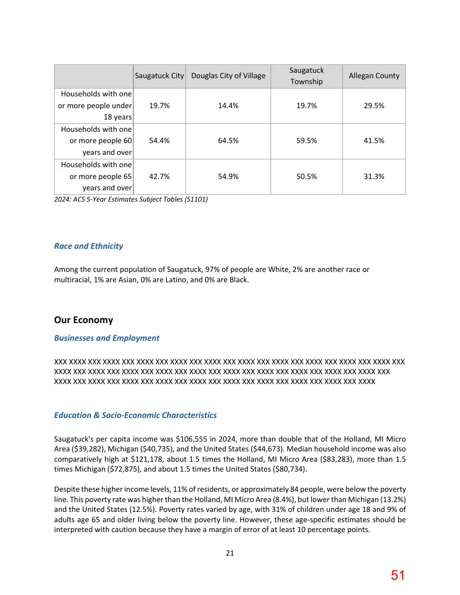
Household Composition In 2024, Saugatuck had 417 households with an average household size of 1.84 persons. This average household size was substantially smaller than the Holland, MI Micro Area (2.6 persons), Michigan (2.4 persons), and the United States (2.5 persons), reflecting the City's relatively large share of smaller households, including retirees, seasonal residents, and oneand two-person households.
Saugatuck City Douglas City of Village Total Households Average Household Size Total Families Average Family Size Householder Living Alone 65 Years & Older Living Alone
Saugatuck Township
Allegan County
1,502
127,544,730
1.84
1.93
2.36
2.54
209 2.5
370 2.51
1,084 2.73
82,464,986 3.15
40.8%
39.8%
20%
28.3%
18.5%
24%
12.7%
11.3%
2024: ACS 5-Year Estimates Subject Tables (S1101)
Page 51
Text of page 51
Saugatuck City Douglas City of Village Households with one or more people under 18 years Households with one or more people 60 years and over Households with one or more people 65 years and over
Saugatuck Township
Allegan County
19.7%
14.4%
19.7%
29.5%
54.4%
64.5%
59.5%
41.5%
42.7%
54.9%
50.5%
31.3%
2024: ACS 5-Year Estimates Subject Tables (S1101)
Race and Ethnicity Among the current population of Saugatuck, 97% of people are White, 2% are another race or multiracial, 1% are Asian, 0% are Latino, and 0% are Black.
Our Economy Businesses and Employment XXX XXXX XXX XXXX XXX XXXX XXX XXXX XXX XXXX XXX XXXX XXX XXXX XXX XXXX XXX XXXX XXX XXXX XXX XXXX XXX XXXX XXX XXXX XXX XXXX XXX XXXX XXX XXXX XXX XXXX XXX XXXX XXX XXXX XXX XXXX XXX XXXX XXX XXXX XXX XXXX XXX XXXX XXX XXXX XXX XXXX XXX XXXX XXX XXXX XXX XXXX XXX XXXX
Education & Socio-Economic Characteristics Saugatuck's per capita income was $106,555 in 2024, more than double that of the Holland, MI Micro Area ($39,282), Michigan ($40,735), and the United States ($44,673). Median household income was also comparatively high at $121,178, about 1.5 times the Holland, MI Micro Area ($83,283), more than 1.5 times Michigan ($72,875), and about 1.5 times the United States ($80,734). Despite these higher income levels, 11% of residents, or approximately 84 people, were below the poverty line. This poverty rate was higher than the Holland, MI Micro Area (8.4%), but lower than Michigan (13.2%) and the United States (12.5%). Poverty rates varied by age, with 31% of children under age 18 and 9% of adults age 65 and older living below the poverty line. However, these age-specific estimates should be interpreted with caution because they have a margin of error of at least 10 percentage points. 21
Page 52
Text of page 52
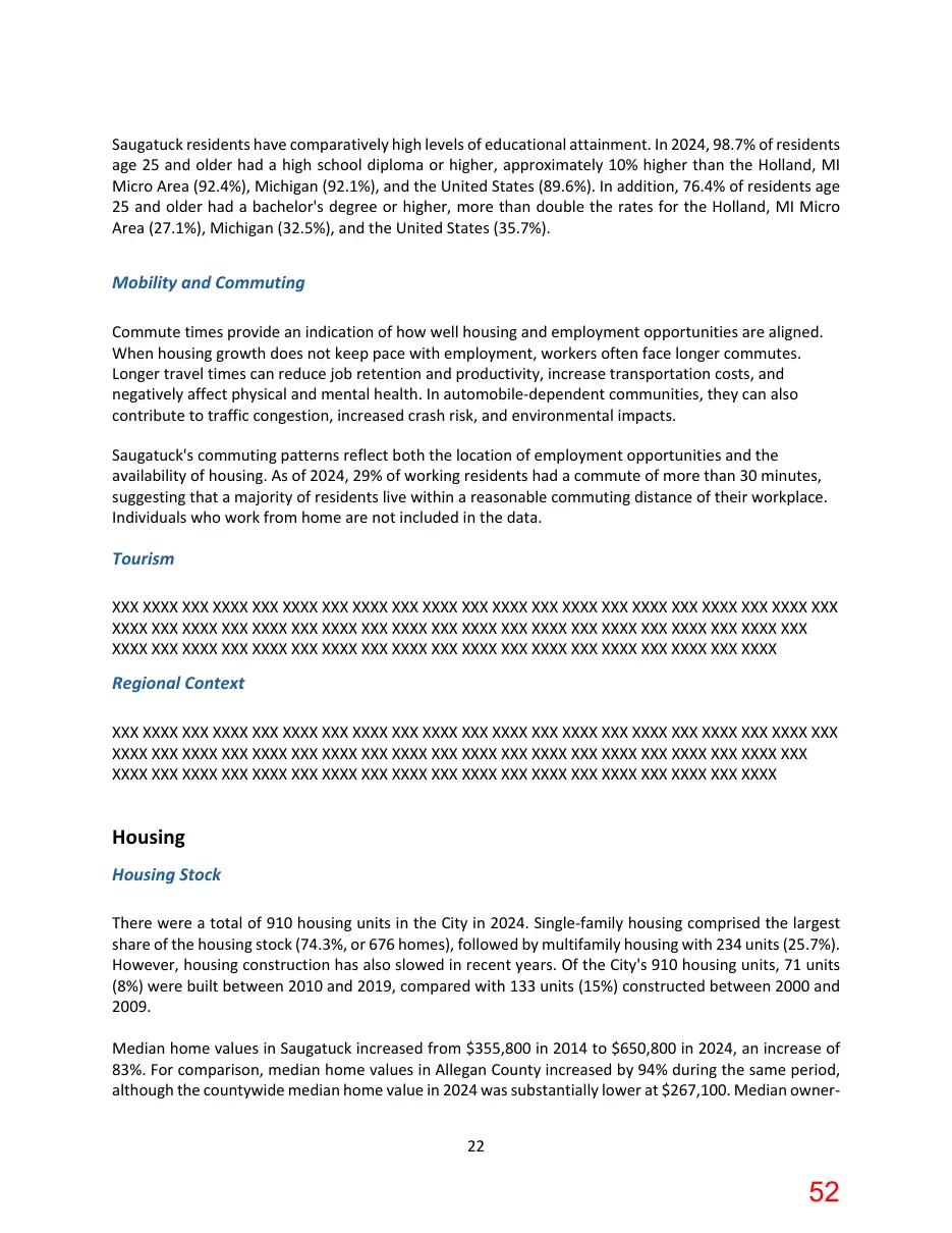
Saugatuck residents have comparatively high levels of educational attainment. In 2024, 98.7% of residents age 25 and older had a high school diploma or higher, approximately 10% higher than the Holland, MI Micro Area (92.4%), Michigan (92.1%), and the United States (89.6%). In addition, 76.4% of residents age 25 and older had a bachelor's degree or higher, more than double the rates for the Holland, MI Micro Area (27.1%), Michigan (32.5%), and the United States (35.7%).
Mobility and Commuting Commute times provide an indication of how well housing and employment opportunities are aligned. When housing growth does not keep pace with employment, workers often face longer commutes. Longer travel times can reduce job retention and productivity, increase transportation costs, and negatively affect physical and mental health. In automobile-dependent communities, they can also contribute to traffic congestion, increased crash risk, and environmental impacts. Saugatuck's commuting patterns reflect both the location of employment opportunities and the availability of housing. As of 2024, 29% of working residents had a commute of more than 30 minutes, suggesting that a majority of residents live within a reasonable commuting distance of their workplace. Individuals who work from home are not included in the data.
Tourism XXX XXXX XXX XXXX XXX XXXX XXX XXXX XXX XXXX XXX XXXX XXX XXXX XXX XXXX XXX XXXX XXX XXXX XXX XXXX XXX XXXX XXX XXXX XXX XXXX XXX XXXX XXX XXXX XXX XXXX XXX XXXX XXX XXXX XXX XXXX XXX XXXX XXX XXXX XXX XXXX XXX XXXX XXX XXXX XXX XXXX XXX XXXX XXX XXXX XXX XXXX XXX XXXX
Regional Context XXX XXXX XXX XXXX XXX XXXX XXX XXXX XXX XXXX XXX XXXX XXX XXXX XXX XXXX XXX XXXX XXX XXXX XXX XXXX XXX XXXX XXX XXXX XXX XXXX XXX XXXX XXX XXXX XXX XXXX XXX XXXX XXX XXXX XXX XXXX XXX XXXX XXX XXXX XXX XXXX XXX XXXX XXX XXXX XXX XXXX XXX XXXX XXX XXXX XXX XXXX XXX XXXX
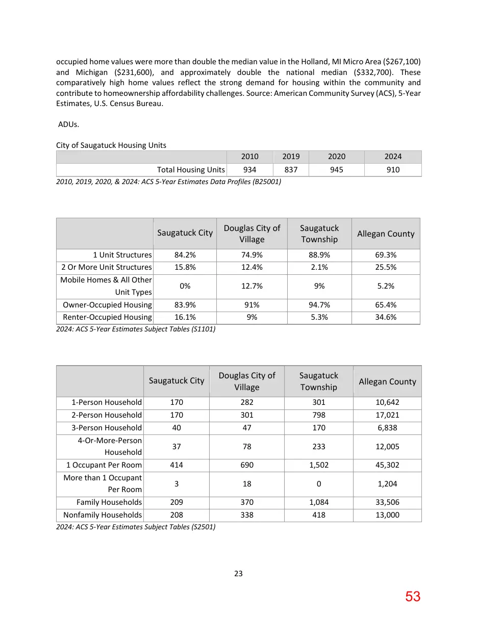
Housing Housing Stock There were a total of 910 housing units in the City in 2024. Single-family housing comprised the largest share of the housing stock (74.3%, or 676 homes), followed by multifamily housing with 234 units (25.7%). However, housing construction has also slowed in recent years. Of the City's 910 housing units, 71 units (8%) were built between 2010 and 2019, compared with 133 units (15%) constructed between 2000 and 2009. Median home values in Saugatuck increased from $355,800 in 2014 to $650,800 in 2024, an increase of 83%. For comparison, median home values in Allegan County increased by 94% during the same period, although the countywide median home value in 2024 was substantially lower at $267,100. Median owner22
Page 53
Text of page 53
occupied home values were more than double the median value in the Holland, MI Micro Area ($267,100) and Michigan ($231,600), and approximately double the national median ($332,700). These comparatively high home values reflect the strong demand for housing within the community and contribute to homeownership affordability challenges. Source: American Community Survey (ACS), 5-Year Estimates, U.S. Census Bureau. ADUs. City of Saugatuck Housing Units Total Housing Units
2010 934
2019 837
2020 945
2024 910
2010, 2019, 2020, & 2024: ACS 5-Year Estimates Data Profiles (B25001)
Saugatuck City
Douglas City of Village
Saugatuck Township
Allegan County
84.2% 15.8%
74.9% 12.4%
88.9% 2.1%
69.3% 25.5%
12.7%
5.2%
83.9% 16.1%
91% 9%
94.7% 5.3%
65.4% 34.6%
Saugatuck City
Douglas City of Village
Saugatuck Township
Allegan County
170 170 40
282 301 47
301 798 170
10,642 17,021 6,838
12,005
1,502
45,302
1,204
209 208
370 338
1,084 418
33,506 13,000
1 Unit Structures 2 Or More Unit Structures Mobile Homes & All Other Unit Types Owner-Occupied Housing Renter-Occupied Housing
2024: ACS 5-Year Estimates Subject Tables (S1101)
1-Person Household 2-Person Household 3-Person Household 4-Or-More-Person Household 1 Occupant Per Room More than 1 Occupant Per Room Family Households Nonfamily Households
2024: ACS 5-Year Estimates Subject Tables (S2501)
Page 54
Text of page 54
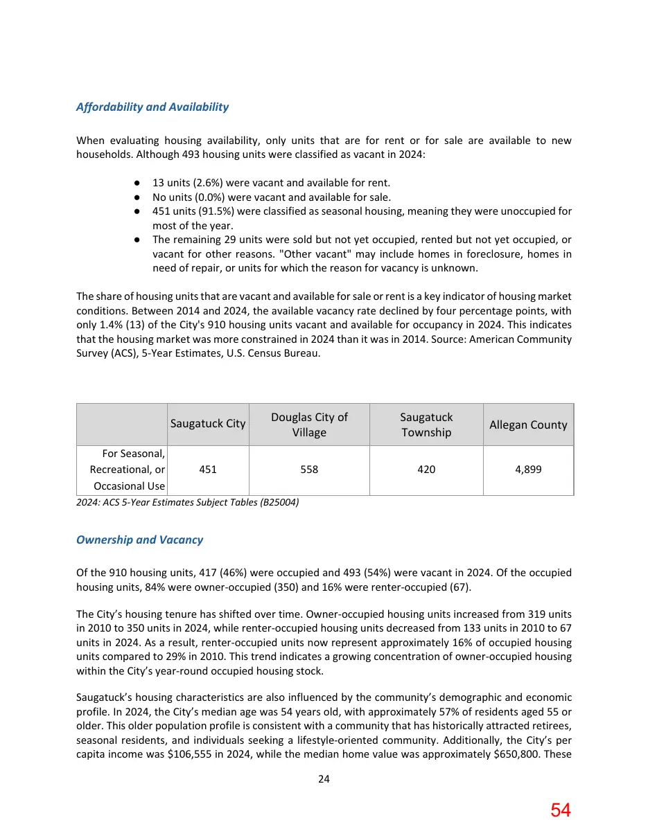
Affordability and Availability When evaluating housing availability, only units that are for rent or for sale are available to new households. Although 493 housing units were classified as vacant in 2024: ● ● ● ●
13 units (2.6%) were vacant and available for rent. No units (0.0%) were vacant and available for sale. 451 units (91.5%) were classified as seasonal housing, meaning they were unoccupied for most of the year. The remaining 29 units were sold but not yet occupied, rented but not yet occupied, or vacant for other reasons. "Other vacant" may include homes in foreclosure, homes in need of repair, or units for which the reason for vacancy is unknown.
The share of housing units that are vacant and available for sale or rent is a key indicator of housing market conditions. Between 2014 and 2024, the available vacancy rate declined by four percentage points, with only 1.4% (13) of the City's 910 housing units vacant and available for occupancy in 2024. This indicates that the housing market was more constrained in 2024 than it was in 2014. Source: American Community Survey (ACS), 5-Year Estimates, U.S. Census Bureau.
For Seasonal, Recreational, or Occasional Use
Saugatuck City
Douglas City of Village
Saugatuck Township
Allegan County
4,899
2024: ACS 5-Year Estimates Subject Tables (B25004)
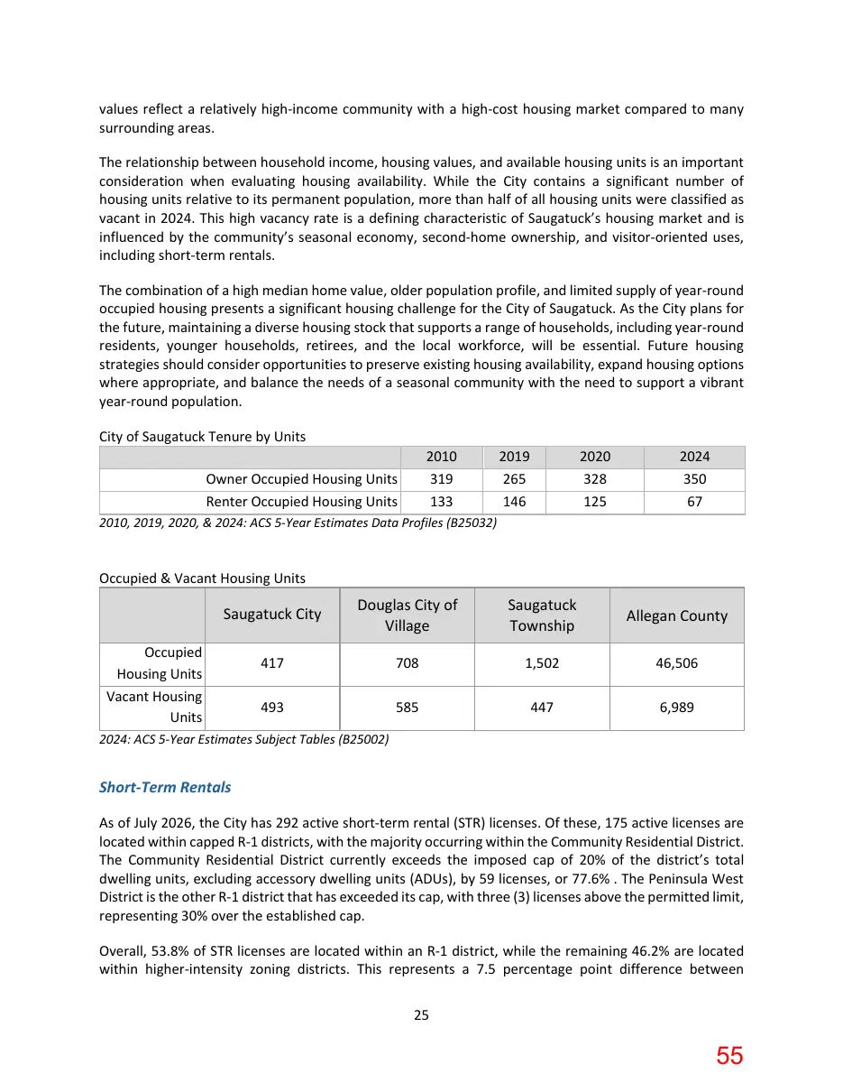
Ownership and Vacancy Of the 910 housing units, 417 (46%) were occupied and 493 (54%) were vacant in 2024. Of the occupied housing units, 84% were owner-occupied (350) and 16% were renter-occupied (67). The City’s housing tenure has shifted over time. Owner-occupied housing units increased from 319 units in 2010 to 350 units in 2024, while renter-occupied housing units decreased from 133 units in 2010 to 67 units in 2024. As a result, renter-occupied units now represent approximately 16% of occupied housing units compared to 29% in 2010. This trend indicates a growing concentration of owner-occupied housing within the City’s year-round occupied housing stock. Saugatuck’s housing characteristics are also influenced by the community’s demographic and economic profile. In 2024, the City’s median age was 54 years old, with approximately 57% of residents aged 55 or older. This older population profile is consistent with a community that has historically attracted retirees, seasonal residents, and individuals seeking a lifestyle-oriented community. Additionally, the City’s per capita income was $106,555 in 2024, while the median home value was approximately $650,800. These 24
Page 55
Text of page 55
values reflect a relatively high-income community with a high-cost housing market compared to many surrounding areas. The relationship between household income, housing values, and available housing units is an important consideration when evaluating housing availability. While the City contains a significant number of housing units relative to its permanent population, more than half of all housing units were classified as vacant in 2024. This high vacancy rate is a defining characteristic of Saugatuck’s housing market and is influenced by the community’s seasonal economy, second-home ownership, and visitor-oriented uses, including short-term rentals. The combination of a high median home value, older population profile, and limited supply of year-round occupied housing presents a significant housing challenge for the City of Saugatuck. As the City plans for the future, maintaining a diverse housing stock that supports a range of households, including year-round residents, younger households, retirees, and the local workforce, will be essential. Future housing strategies should consider opportunities to preserve existing housing availability, expand housing options where appropriate, and balance the needs of a seasonal community with the need to support a vibrant year-round population. City of Saugatuck Tenure by Units 2010 319 133
Owner Occupied Housing Units Renter Occupied Housing Units
2019 265 146
2020 328 125
2024 350 67
2010, 2019, 2020, & 2024: ACS 5-Year Estimates Data Profiles (B25032)
Occupied & Vacant Housing Units
Saugatuck City
Douglas City of Village
Saugatuck Township
Allegan County
1,502
46,506
6,989
Occupied Housing Units Vacant Housing Units
2024: ACS 5-Year Estimates Subject Tables (B25002)
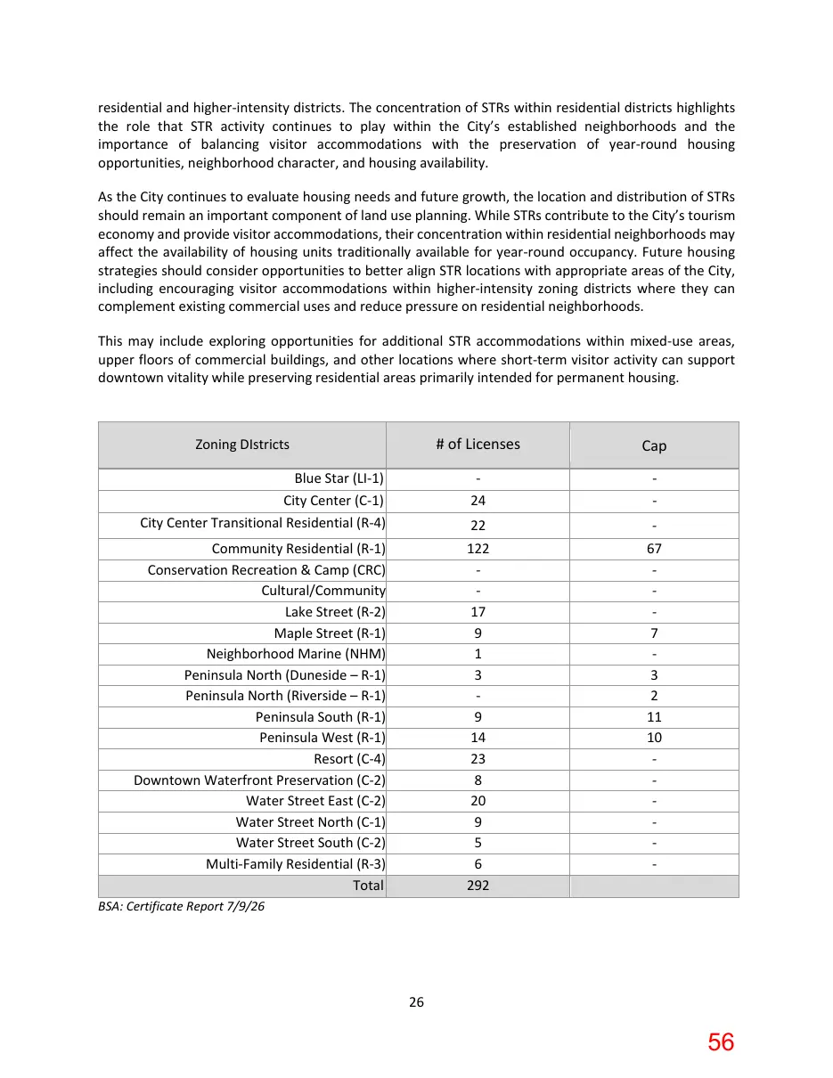
Short-Term Rentals As of July 2026, the City has 292 active short-term rental (STR) licenses. Of these, 175 active licenses are located within capped R-1 districts, with the majority occurring within the Community Residential District. The Community Residential District currently exceeds the imposed cap of 20% of the district’s total dwelling units, excluding accessory dwelling units (ADUs), by 59 licenses, or 77.6% . The Peninsula West District is the other R-1 district that has exceeded its cap, with three (3) licenses above the permitted limit, representing 30% over the established cap. Overall, 53.8% of STR licenses are located within an R-1 district, while the remaining 46.2% are located within higher-intensity zoning districts. This represents a 7.5 percentage point difference between 25
Page 56
Text of page 56
residential and higher-intensity districts. The concentration of STRs within residential districts highlights the role that STR activity continues to play within the City’s established neighborhoods and the importance of balancing visitor accommodations with the preservation of year-round housing opportunities, neighborhood character, and housing availability. As the City continues to evaluate housing needs and future growth, the location and distribution of STRs should remain an important component of land use planning. While STRs contribute to the City’s tourism economy and provide visitor accommodations, their concentration within residential neighborhoods may affect the availability of housing units traditionally available for year-round occupancy. Future housing strategies should consider opportunities to better align STR locations with appropriate areas of the City, including encouraging visitor accommodations within higher-intensity zoning districts where they can complement existing commercial uses and reduce pressure on residential neighborhoods. This may include exploring opportunities for additional STR accommodations within mixed-use areas, upper floors of commercial buildings, and other locations where short-term visitor activity can support downtown vitality while preserving residential areas primarily intended for permanent housing.
Zoning DIstricts
# of Licenses
Cap
Blue Star (LI-1) City Center (C-1) City Center Transitional Residential (R-4)
Community Residential (R-1) Conservation Recreation & Camp (CRC) Cultural/Community Lake Street (R-2) Maple Street (R-1) Neighborhood Marine (NHM) Peninsula North (Duneside – R-1) Peninsula North (Riverside – R-1) Peninsula South (R-1) Peninsula West (R-1) Resort (C-4) Downtown Waterfront Preservation (C-2) Water Street East (C-2) Water Street North (C-1) Water Street South (C-2) Multi-Family Residential (R-3) Total
122 17 9 1 3 9 14 23 8 20 9 5 6 292
67 7 3 2 11 10 -
BSA: Certificate Report 7/9/26
Page 57
Text of page 57
Conclusion Understanding the City's history, community perspectives, demographic characteristics, and housing and economic conditions provides the foundation for sound planning decisions. Together, these topics establish the context needed to identify community needs, evaluate opportunities and constraints, and develop recommendations in the upcoming chapters that are both responsive to existing conditions and consistent with the community's long-term vision.
Page 58
Text of page 58
Chapter 3: Community Character Introduction and Goal This chapter examines the physical character, identity, and sense of place that define the City of Saugatuck. Community character is shaped not only by land use but also by the relationships among buildings, streets, neighborhoods, waterfronts, natural features, and public spaces that collectively create the City's unique identity. Understanding these characteristics provides the foundation for future land use planning, urban design, historic preservation, and policy decisions that seek to preserve what makes Saugatuck distinctive while accommodating thoughtful change. This chapter includes a character analysis, an existing land use assessment, and a discussion of urban design, transitional areas, gateways, wayfinding, and historic preservation to establish a framework for maintaining and enhancing the community's character over time. 1. Option 1 Goal: Preserve and enhance Saugatuck's unique community character by protecting its historic resources, waterfront setting, natural environment, and established neighborhoods while guiding compatible growth, redevelopment, and public investment that reinforces the City's distinctive sense of place. 2. Option 2 Goal: Preserve and strengthen the physical character and sense of place that make Saugatuck unique while ensuring that future growth and redevelopment are compatible with the community's established identity. 3. Option 3 Goal: Guide future land use, development, and public improvements in a manner that reinforces Saugatuck's historic character, walkability, neighborhood identity, waterfront, and natural landscape. 4. Option 4 Goal: Maintain and enhance the distinct character of Saugatuck's neighborhoods, downtown, waterfront, and natural areas by ensuring that future planning and development respect the qualities that define each planning area and character district. 5. Option 5 Goal: Promote thoughtful growth and reinvestment that preserves Saugatuck's smalltown character, protects historic and natural resources, strengthens neighborhood transitions, and enhances the community's identity for residents and visitors. 6. Option 6 Goal: Preserve, enhance, and celebrate the distinctive character of Saugatuck by protecting its historic downtown, established neighborhoods, waterfronts, and natural landscapes while guiding future land use, development, and public improvements that are compatible with the City's unique sense of place.
Page 59
Text of page 59
Character Analysis Intent The City Community Character Analysis is intended to better understand the unique qualities of the City and its neighborhoods in ways that a traditional existing land use map alone cannot capture. Rather than serving as a simple inventory of land uses, the analysis evaluates the physical and functional characteristics that define districts, neighborhoods, and corridors, including development scale, block and lot patterns, street and sidewalk networks, pathways, parking, building types, and land use relationships. This approach serves as a basis for identifying areas to preserve, enhance, or thoughtfully transform, and will provide a stronger foundation for future land use recommendations and zoning policy decisions. The intent was to identify what makes areas similar or different based on real-world characteristics rather than regulatory boundaries. Ultimately, the character analysis is intended to ensure that future growth and development align with Saugatuck’s established character and community context. To better understand the City’s physical form and development patterns, the community has been divided into character areas. These areas represent distinct parts of the City that share common patterns in land use, development intensity, built form, and environmental context. This analysis serves several purposes: ▪ Classifies areas based on common characteristics, including land use, zoning, density, intensity, infrastructure, and utilities, and helps to define a sense of place. ▪ Establishes a clear and simplified framework for future growth and land use planning. ▪ Provides justification for future land use recommendations and distinctions between different parts of the City.
Each character area is evaluated using the following components: ▪ Buildings: Predominant building types, setbacks, architectural character, and general form. ▪ Land Use: Primary and supporting uses within the area. ▪ Scale: Building height, massing, and overall development intensity. ▪ Blocks and Streets: Block patterns, street layout (grid, curvilinear, etc.), and connectivity. ▪ Streetscape: Sidewalks, street trees, lighting, and pedestrian environment. ▪ Public Space: Parks, plazas, waterfront access, and civic spaces. ▪ Parking: On-street and off-street parking patterns and visibility. ▪ Walkability: Distance from downtown and ease of pedestrian travel.
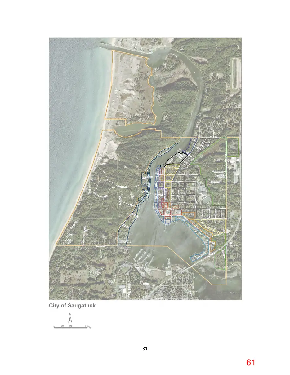
Planning Areas The City has been organized into three primary planning areas, each containing multiple distinct character areas. This structure is intended to provide a clear, manageable framework for understanding and evaluating the City from a planning perspective. By grouping character areas within broader planning 29
Page 60
Text of page 60
areas, the analysis can focus on both larger geographic patterns and the finer-grained distinctions between neighborhoods, districts, and corridors. ▪ Central City
Central Downtown Activity Center
Downtown Waterfront Commercial
Downtown Neighborhood Mixed-Use
Transitional Residential
Central City Residential
▪ East Side Neighborhoods
Traditional Neighborhood Residential
North Riverfront Residential
South Riverfront Mixed Residential
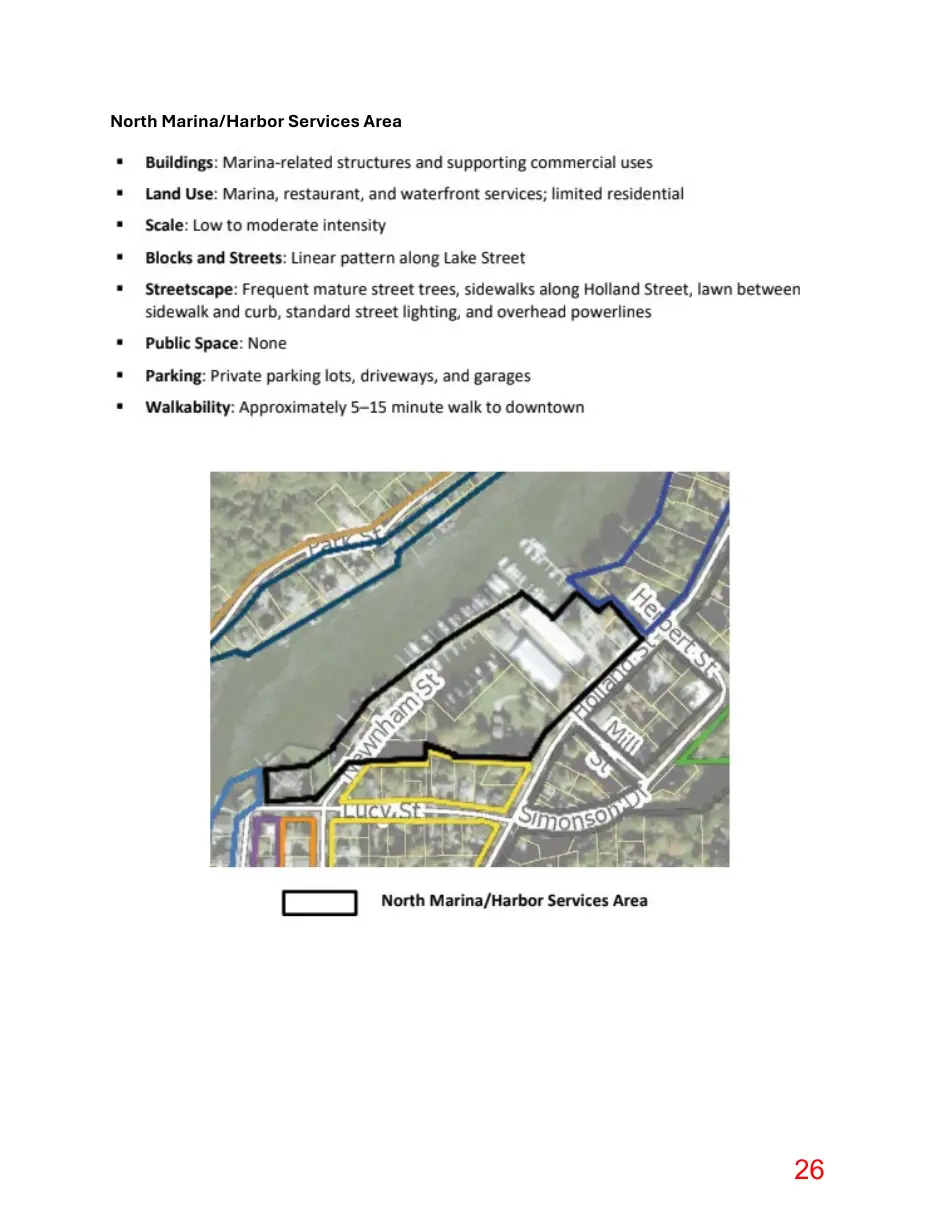
North Marina/Harbor Services Area
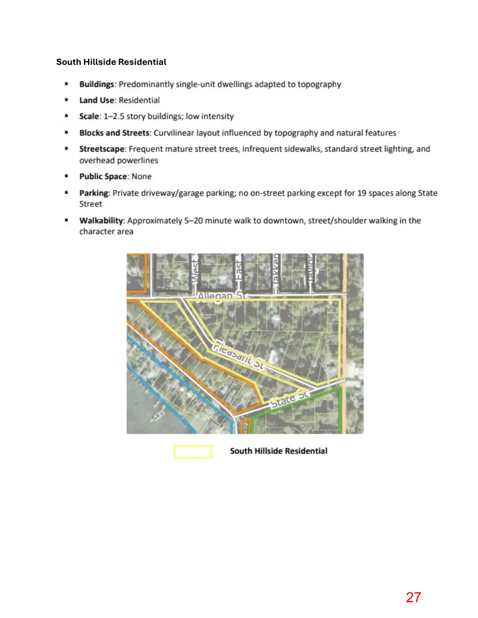
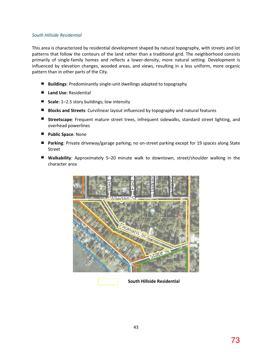
South Hillside Residential
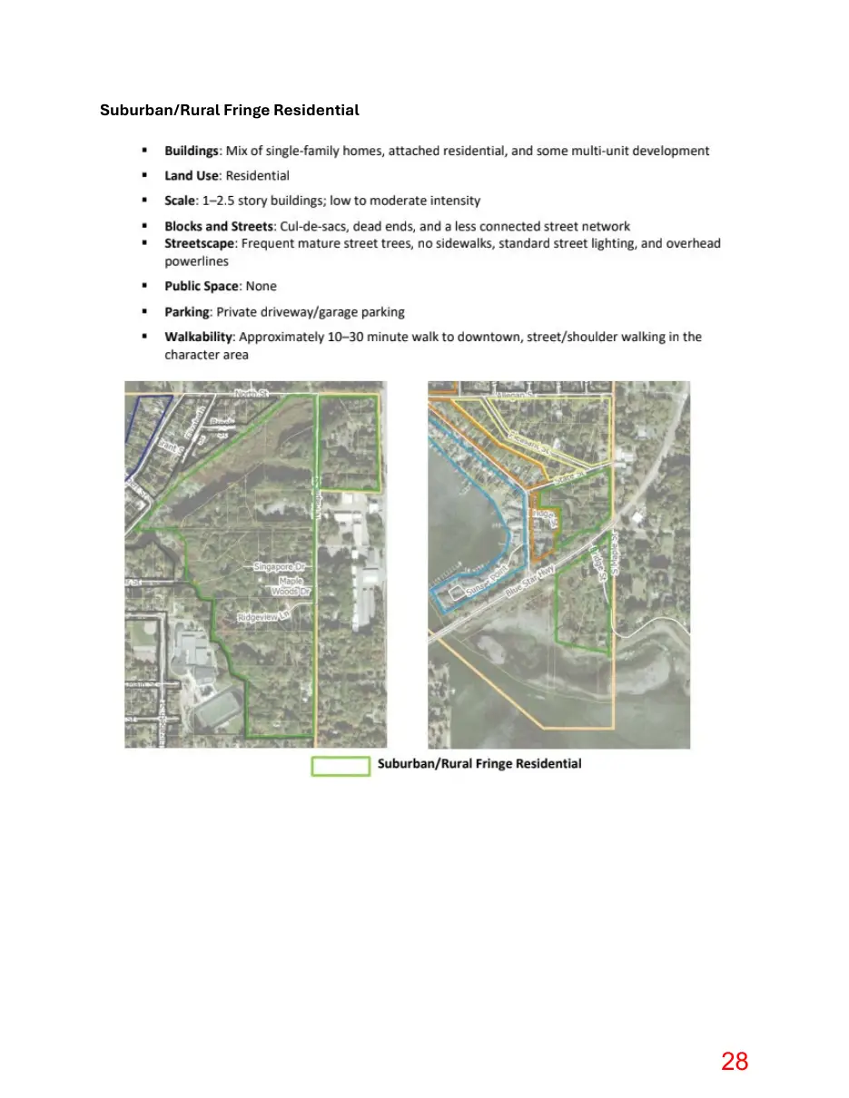
Suburban/Rural Fringe Residential
▪ Coastal Dunes and Peninsula
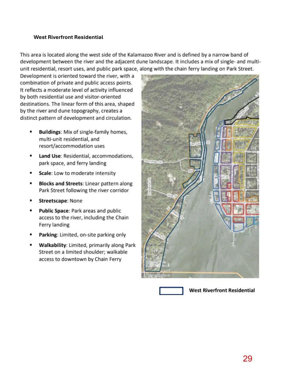
West Riverfront Residential
Coastal Dune Residential
The planning areas reflect natural divisions within the community, shaped by geography, waterfront features, transportation patterns, and the overall arrangement of development. This approach allows for a more organized and practical assessment of existing conditions, ensuring that major portions of the City can be evaluated cohesively while still recognizing the unique characteristics that define smaller areas within each planning area.
Page 61
This page is a scanned image with no text layer. The PDF of these pages has it at full resolution.
Page 62
Text of page 62
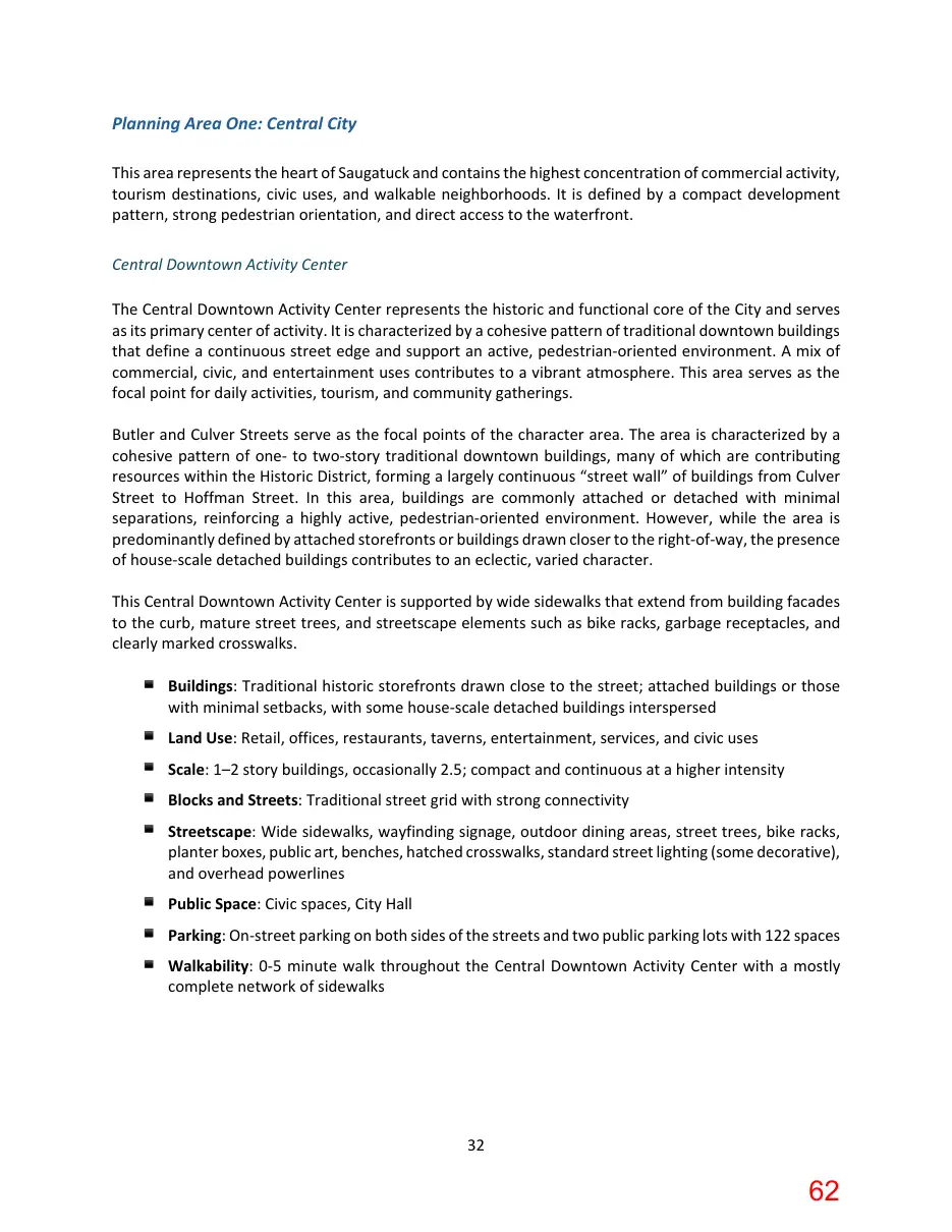
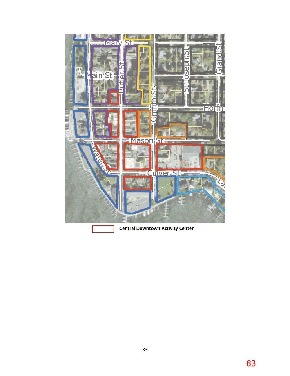
Planning Area One: Central City This area represents the heart of Saugatuck and contains the highest concentration of commercial activity, tourism destinations, civic uses, and walkable neighborhoods. It is defined by a compact development pattern, strong pedestrian orientation, and direct access to the waterfront. Central Downtown Activity Center The Central Downtown Activity Center represents the historic and functional core of the City and serves as its primary center of activity. It is characterized by a cohesive pattern of traditional downtown buildings that define a continuous street edge and support an active, pedestrian-oriented environment. A mix of commercial, civic, and entertainment uses contributes to a vibrant atmosphere. This area serves as the focal point for daily activities, tourism, and community gatherings. Butler and Culver Streets serve as the focal points of the character area. The area is characterized by a cohesive pattern of oneto two-story traditional downtown buildings, many of which are contributing resources within the Historic District, forming a largely continuous “street wall” of buildings from Culver Street to Hoffman Street. In this area, buildings are commonly attached or detached with minimal separations, reinforcing a highly active, pedestrian-oriented environment. However, while the area is predominantly defined by attached storefronts or buildings drawn closer to the right-of-way, the presence of house-scale detached buildings contributes to an eclectic, varied character. This Central Downtown Activity Center is supported by wide sidewalks that extend from building facades to the curb, mature street trees, and streetscape elements such as bike racks, garbage receptacles, and clearly marked crosswalks. ▪ Buildings: Traditional historic storefronts drawn close to the street; attached buildings or those with minimal setbacks, with some house-scale detached buildings interspersed ▪ Land Use: Retail, offices, restaurants, taverns, entertainment, services, and civic uses ▪ Scale: 1–2 story buildings, occasionally 2.5; compact and continuous at a higher intensity ▪ Blocks and Streets: Traditional street grid with strong connectivity ▪ Streetscape: Wide sidewalks, wayfinding signage, outdoor dining areas, street trees, bike racks, planter boxes, public art, benches, hatched crosswalks, standard street lighting (some decorative), and overhead powerlines ▪ Public Space: Civic spaces, City Hall ▪ Parking: On-street parking on both sides of the streets and two public parking lots with 122 spaces ▪ Walkability: 0-5 minute walk throughout the Central Downtown Activity Center with a mostly complete network of sidewalks
Page 63
Text of page 63
Central Downtown Activity Center
Page 64
Text of page 64
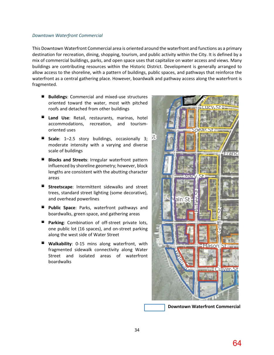
Downtown Waterfront Commercial This Downtown Waterfront Commercial area is oriented around the waterfront and functions as a primary destination for recreation, dining, shopping, tourism, and public activity within the City. It is defined by a mix of commercial buildings, parks, and open space uses that capitalize on water access and views. Many buildings are contributing resources within the Historic District. Development is generally arranged to allow access to the shoreline, with a pattern of buildings, public spaces, and pathways that reinforce the waterfront as a central gathering place. However, boardwalk and pathway access along the waterfront is fragmented. ▪ Buildings: Commercial and mixed-use structures oriented toward the water, most with pitched roofs and detached from other buildings ▪ Land Use: Retail, restaurants, marinas, hotel accommodations, recreation, and tourismoriented uses ▪ Scale: 1–2.5 story buildings, occasionally 3; moderate intensity with a varying and diverse scale of buildings ▪ Blocks and Streets: Irregular waterfront pattern influenced by shoreline geometry; however, block lengths are consistent with the abutting character areas ▪ Streetscape: Intermittent sidewalks and street trees, standard street lighting (some decorative), and overhead powerlines ▪ Public Space: Parks, waterfront pathways and boardwalks, green space, and gathering areas ▪ Parking: Combination of off-street private lots, one public lot (16 spaces), and on-street parking along the west side of Water Street ▪ Walkability: 0-15 mins along waterfront, with fragmented sidewalk connectivity along Water Street and isolated areas of waterfront boardwalks
Downtown Waterfront Commercial
Page 65
Text of page 65
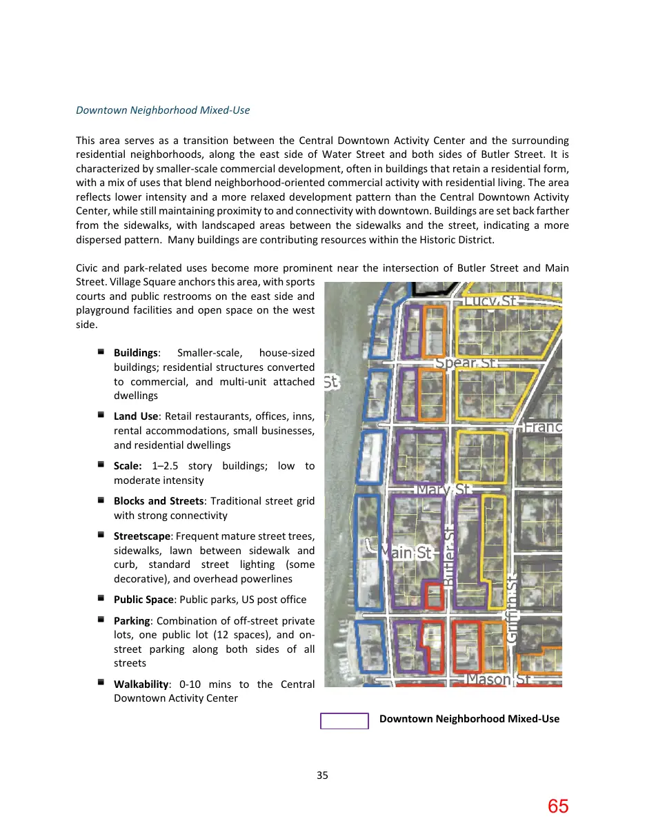
Downtown Neighborhood Mixed-Use This area serves as a transition between the Central Downtown Activity Center and the surrounding residential neighborhoods, along the east side of Water Street and both sides of Butler Street. It is characterized by smaller-scale commercial development, often in buildings that retain a residential form, with a mix of uses that blend neighborhood-oriented commercial activity with residential living. The area reflects lower intensity and a more relaxed development pattern than the Central Downtown Activity Center, while still maintaining proximity to and connectivity with downtown. Buildings are set back farther from the sidewalks, with landscaped areas between the sidewalks and the street, indicating a more dispersed pattern. Many buildings are contributing resources within the Historic District. Civic and park-related uses become more prominent near the intersection of Butler Street and Main Street. Village Square anchors this area, with sports courts and public restrooms on the east side and playground facilities and open space on the west side. ▪ Buildings: Smaller-scale, house-sized buildings; residential structures converted to commercial, and multi-unit attached dwellings ▪ Land Use: Retail restaurants, offices, inns, rental accommodations, small businesses, and residential dwellings ▪ Scale: 1–2.5 story buildings; low to moderate intensity ▪ Blocks and Streets: Traditional street grid with strong connectivity ▪ Streetscape: Frequent mature street trees, sidewalks, lawn between sidewalk and curb, standard street lighting (some decorative), and overhead powerlines ▪ Public Space: Public parks, US post office ▪ Parking: Combination of off-street private lots, one public lot (12 spaces), and onstreet parking along both sides of all streets ▪ Walkability: 0-10 mins to the Central Downtown Activity Center
Downtown Neighborhood Mixed-Use
Page 66
Text of page 66
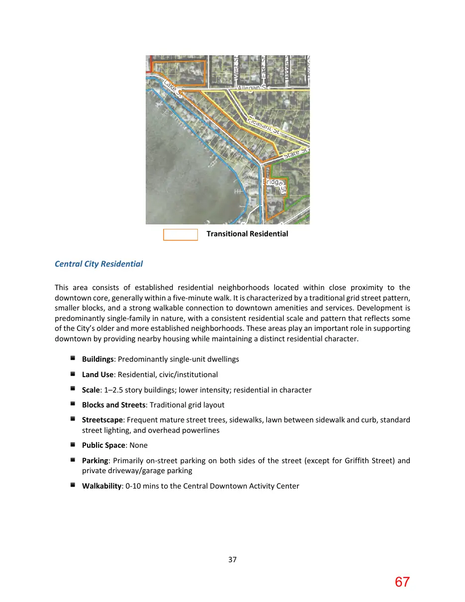
Transitional Residential These areas serve as a transition between the more intense downtown commercial and mixed-use areas and the surrounding residential neighborhoods. They are primarily residential in character but may include a mix of housing types, limited accommodation uses (such as bed and breakfasts and motor courts), and some limited-scale non-residential uses. Buildings are generally residential in scale and form, and development patterns reflect a gradual shift from the activity and intensity of downtown to quieter neighborhood settings. This area maintains convenient walkable access to the downtown core. While mostly east of the Central Downtown Activity Center and Downtown Neighborhood Mixed-Use, this character area also stretches south along the east side of Lake Street to Blue Star Highway. ▪ Buildings: Single-unit dwellings, bed and breakfast establishments, motor courts, and multi-unit attached dwellings ▪ Land Use: Primarily residential, with bed and breakfast accommodations, inns, and motor courts ▪ Scale: 1–2.5 story buildings; lower intensity; residential in character ▪ Blocks and Streets: Traditional grid pattern to the north, although a curvilinear pattern south of Culver along Lake Street ▪ Streetscape: Frequent mature street trees, sidewalks, lawn between sidewalk and curb, standard street lighting, and overhead powerlines ▪ Public Space: None ▪ Parking: Some on-street parking near downtown, private driveway/garage parking; no on-street parking along Lake Street, but a 24-space public/private lot is available ▪ Walkability: 0-20 mins to the Central Downtown Activity Center
Transitional Residential
Page 67
Text of page 67
Transitional Residential
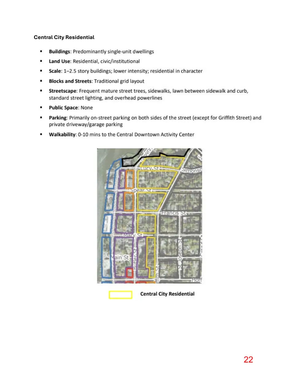
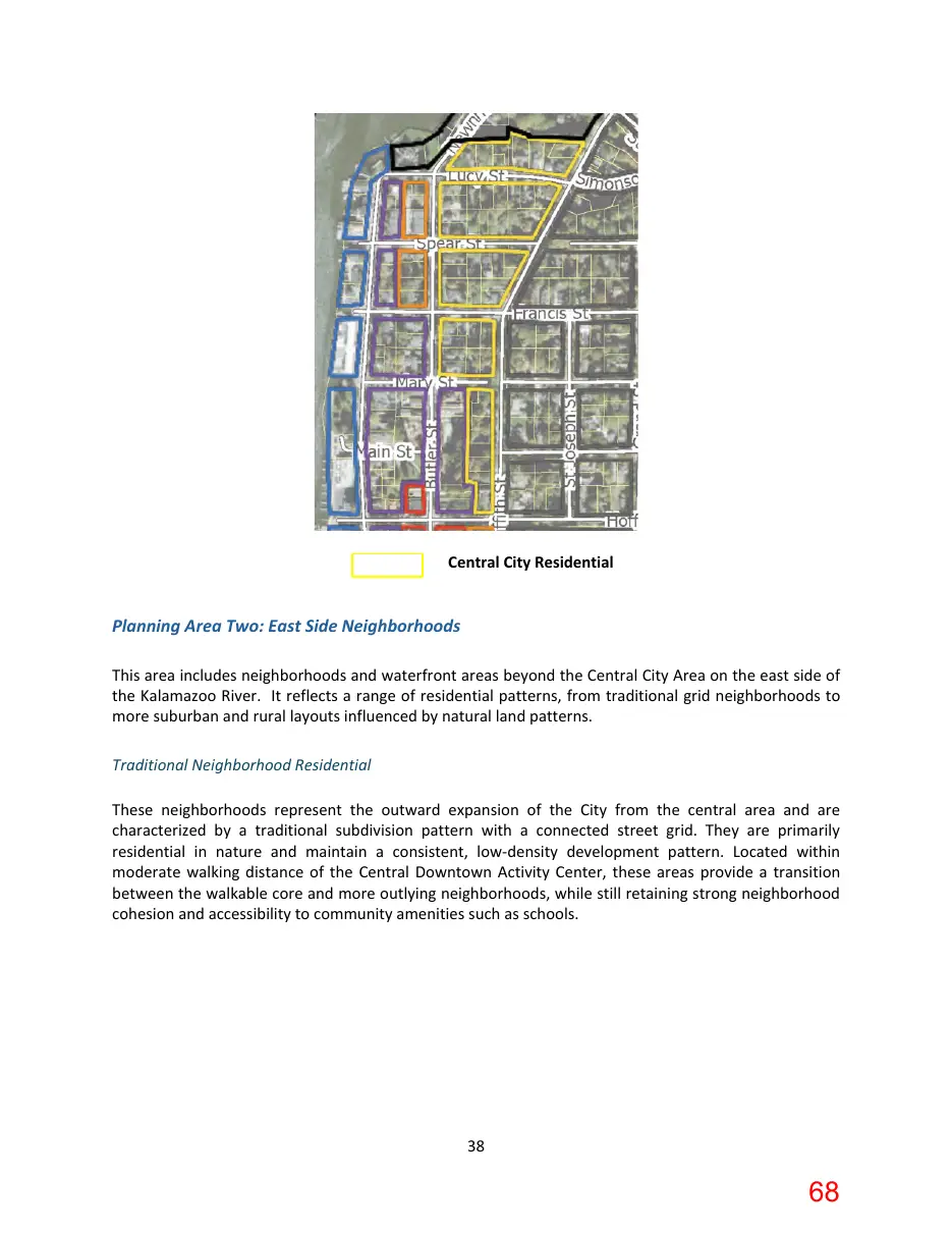
Central City Residential This area consists of established residential neighborhoods located within close proximity to the downtown core, generally within a five-minute walk. It is characterized by a traditional grid street pattern, smaller blocks, and a strong walkable connection to downtown amenities and services. Development is predominantly single-family in nature, with a consistent residential scale and pattern that reflects some of the City’s older and more established neighborhoods. These areas play an important role in supporting downtown by providing nearby housing while maintaining a distinct residential character. ▪ Buildings: Predominantly single-unit dwellings ▪ Land Use: Residential, civic/institutional ▪ Scale: 1–2.5 story buildings; lower intensity; residential in character ▪ Blocks and Streets: Traditional grid layout ▪ Streetscape: Frequent mature street trees, sidewalks, lawn between sidewalk and curb, standard street lighting, and overhead powerlines ▪ Public Space: None ▪ Parking: Primarily on-street parking on both sides of the street (except for Griffith Street) and private driveway/garage parking ▪ Walkability: 0-10 mins to the Central Downtown Activity Center
Page 68
Text of page 68
Central City Residential
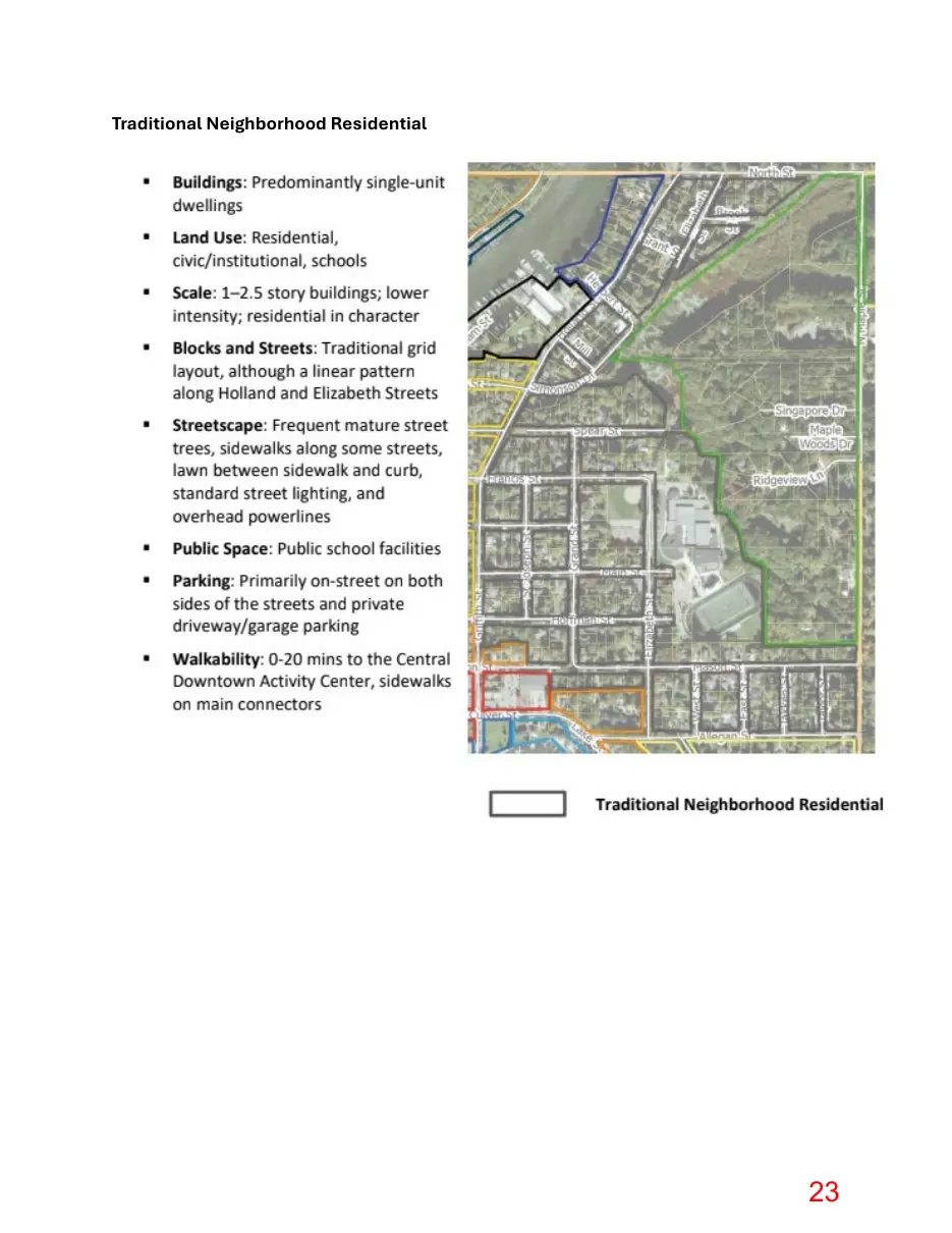
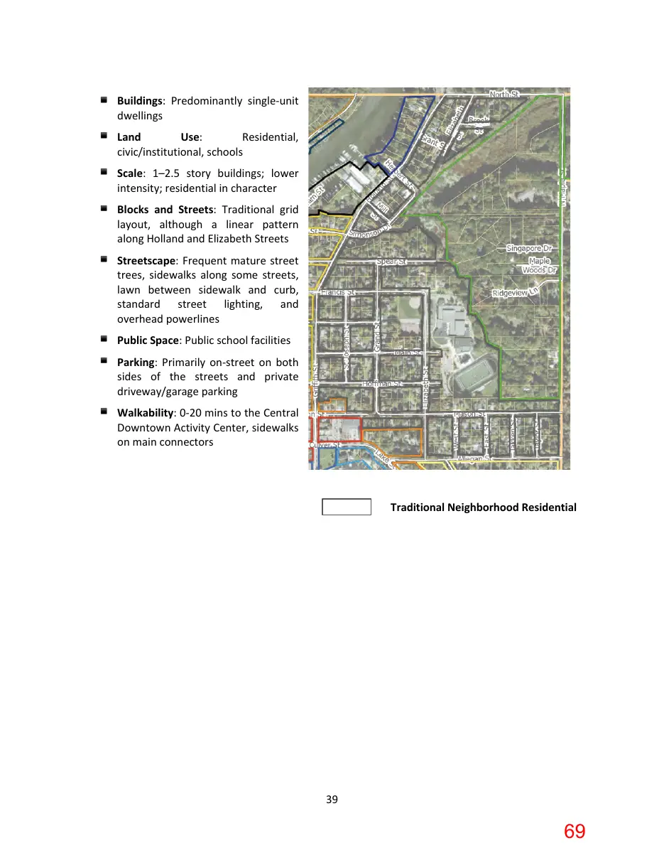
Planning Area Two: East Side Neighborhoods This area includes neighborhoods and waterfront areas beyond the Central City Area on the east side of the Kalamazoo River. It reflects a range of residential patterns, from traditional grid neighborhoods to more suburban and rural layouts influenced by natural land patterns. Traditional Neighborhood Residential These neighborhoods represent the outward expansion of the City from the central area and are characterized by a traditional subdivision pattern with a connected street grid. They are primarily residential in nature and maintain a consistent, low-density development pattern. Located within moderate walking distance of the Central Downtown Activity Center, these areas provide a transition between the walkable core and more outlying neighborhoods, while still retaining strong neighborhood cohesion and accessibility to community amenities such as schools.
Page 69
Text of page 69
▪ Buildings: Predominantly single-unit dwellings ▪ Land Use: Residential, civic/institutional, schools ▪ Scale: 1–2.5 story buildings; lower intensity; residential in character ▪ Blocks and Streets: Traditional grid layout, although a linear pattern along Holland and Elizabeth Streets ▪ Streetscape: Frequent mature street trees, sidewalks along some streets, lawn between sidewalk and curb, standard street lighting, and overhead powerlines ▪ Public Space: Public school facilities ▪ Parking: Primarily on-street on both sides of the streets and private driveway/garage parking ▪ Walkability: 0-20 mins to the Central Downtown Activity Center, sidewalks on main connectors
Traditional Neighborhood Residential
Page 70
Text of page 70
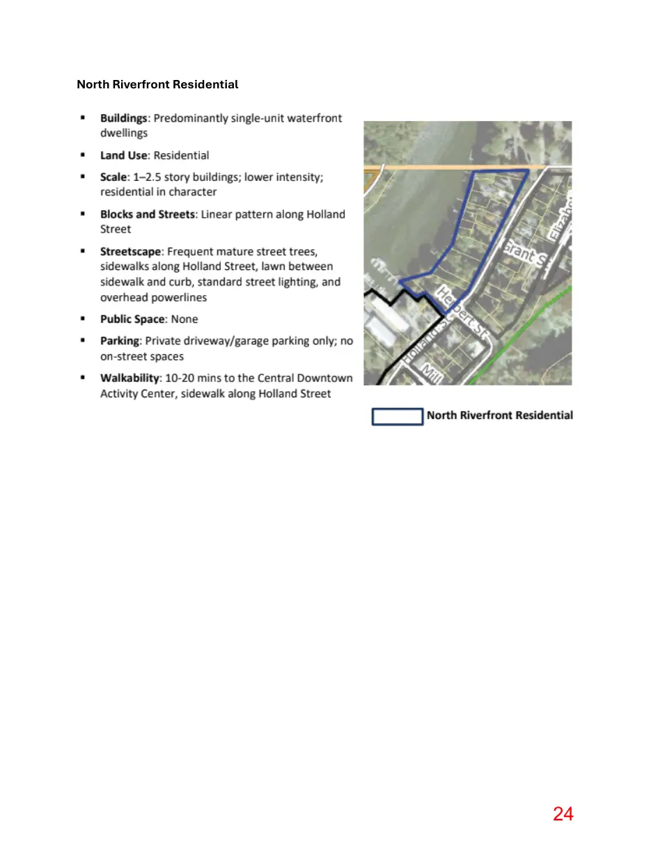
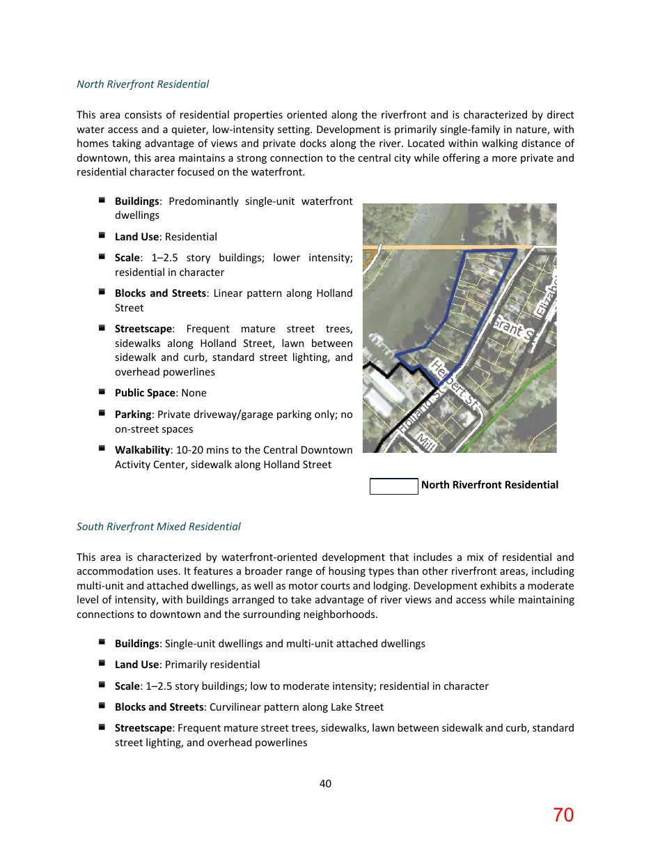
North Riverfront Residential This area consists of residential properties oriented along the riverfront and is characterized by direct water access and a quieter, low-intensity setting. Development is primarily single-family in nature, with homes taking advantage of views and private docks along the river. Located within walking distance of downtown, this area maintains a strong connection to the central city while offering a more private and residential character focused on the waterfront. ▪ Buildings: Predominantly single-unit waterfront dwellings ▪ Land Use: Residential ▪ Scale: 1–2.5 story buildings; lower intensity; residential in character ▪ Blocks and Streets: Linear pattern along Holland Street ▪ Streetscape: Frequent mature street trees, sidewalks along Holland Street, lawn between sidewalk and curb, standard street lighting, and overhead powerlines ▪ Public Space: None ▪ Parking: Private driveway/garage parking only; no on-street spaces ▪ Walkability: 10-20 mins to the Central Downtown Activity Center, sidewalk along Holland Street
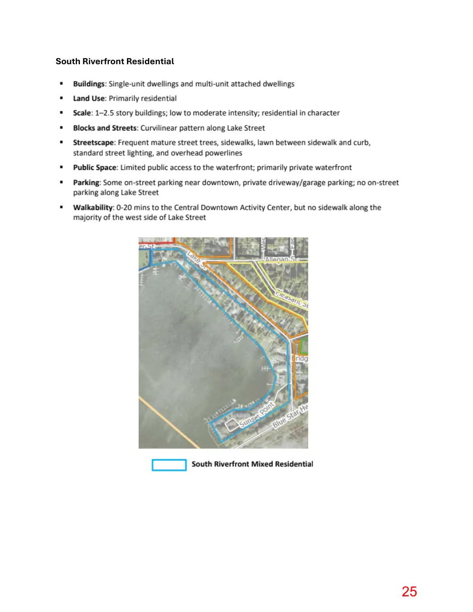
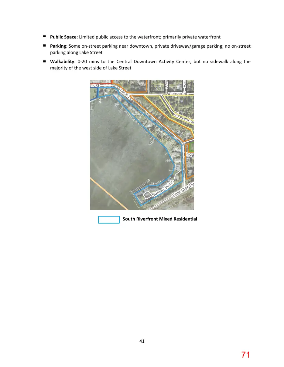
North Riverfront Residential South Riverfront Mixed Residential This area is characterized by waterfront-oriented development that includes a mix of residential and accommodation uses. It features a broader range of housing types than other riverfront areas, including multi-unit and attached dwellings, as well as motor courts and lodging. Development exhibits a moderate level of intensity, with buildings arranged to take advantage of river views and access while maintaining connections to downtown and the surrounding neighborhoods. ▪ Buildings: Single-unit dwellings and multi-unit attached dwellings ▪ Land Use: Primarily residential ▪ Scale: 1–2.5 story buildings; low to moderate intensity; residential in character ▪ Blocks and Streets: Curvilinear pattern along Lake Street ▪ Streetscape: Frequent mature street trees, sidewalks, lawn between sidewalk and curb, standard street lighting, and overhead powerlines
Page 71
Text of page 71
▪ Public Space: Limited public access to the waterfront; primarily private waterfront ▪ Parking: Some on-street parking near downtown, private driveway/garage parking; no on-street parking along Lake Street ▪ Walkability: 0-20 mins to the Central Downtown Activity Center, but no sidewalk along the majority of the west side of Lake Street
South Riverfront Mixed Residential
Page 72
Text of page 72
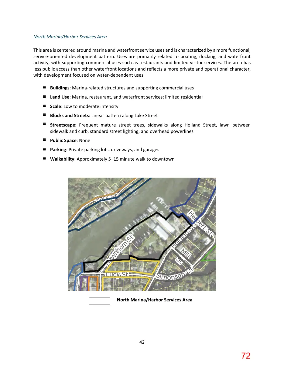
North Marina/Harbor Services Area This area is centered around marina and waterfront service uses and is characterized by a more functional, service-oriented development pattern. Uses are primarily related to boating, docking, and waterfront activity, with supporting commercial uses such as restaurants and limited visitor services. The area has less public access than other waterfront locations and reflects a more private and operational character, with development focused on water-dependent uses. ▪ Buildings: Marina-related structures and supporting commercial uses ▪ Land Use: Marina, restaurant, and waterfront services; limited residential ▪ Scale: Low to moderate intensity ▪ Blocks and Streets: Linear pattern along Lake Street ▪ Streetscape: Frequent mature street trees, sidewalks along Holland Street, lawn between sidewalk and curb, standard street lighting, and overhead powerlines ▪ Public Space: None ▪ Parking: Private parking lots, driveways, and garages ▪ Walkability: Approximately 5–15 minute walk to downtown
North Marina/Harbor Services Area
Page 73
Text of page 73
South Hillside Residential This area is characterized by residential development shaped by natural topography, with streets and lot patterns that follow the contours of the land rather than a traditional grid. The neighborhood consists primarily of single-family homes and reflects a lower-density, more natural setting. Development is influenced by elevation changes, wooded areas, and views, resulting in a less uniform, more organic pattern than in other parts of the City. ▪ Buildings: Predominantly single-unit dwellings adapted to topography ▪ Land Use: Residential ▪ Scale: 1–2.5 story buildings; low intensity ▪ Blocks and Streets: Curvilinear layout influenced by topography and natural features ▪ Streetscape: Frequent mature street trees, infrequent sidewalks, standard street lighting, and overhead powerlines ▪ Public Space: None ▪ Parking: Private driveway/garage parking; no on-street parking except for 19 spaces along State Street ▪ Walkability: Approximately 5–20 minute walk to downtown, street/shoulder walking in the character area
South Hillside Residential
Page 74
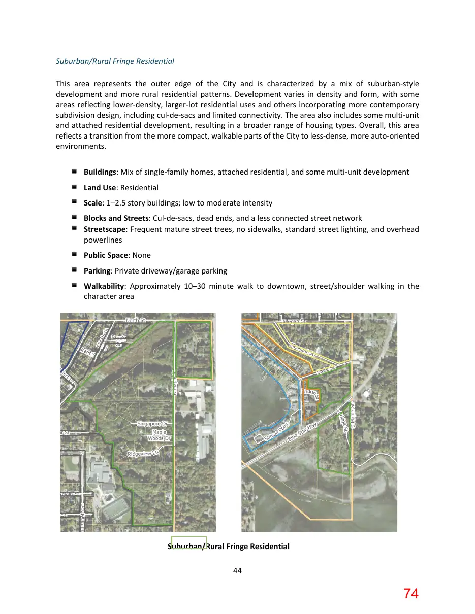
Text of page 74
Suburban/Rural Fringe Residential This area represents the outer edge of the City and is characterized by a mix of suburban-style development and more rural residential patterns. Development varies in density and form, with some areas reflecting lower-density, larger-lot residential uses and others incorporating more contemporary subdivision design, including cul-de-sacs and limited connectivity. The area also includes some multi-unit and attached residential development, resulting in a broader range of housing types. Overall, this area reflects a transition from the more compact, walkable parts of the City to less-dense, more auto-oriented environments. ▪ Buildings: Mix of single-family homes, attached residential, and some multi-unit development ▪ Land Use: Residential ▪ Scale: 1–2.5 story buildings; low to moderate intensity ▪ Blocks and Streets: Cul-de-sacs, dead ends, and a less connected street network ▪ Streetscape: Frequent mature street trees, no sidewalks, standard street lighting, and overhead powerlines ▪ Public Space: None ▪ Parking: Private driveway/garage parking ▪ Walkability: Approximately 10–30 minute walk to downtown, street/shoulder walking in the character area
Suburban/Rural Fringe Residential 44
Page 75
Text of page 75
Planning Area Three: Coastal Dunes and Peninsula This planning area is defined by its unique environmental features, including dunes, waterfront, and protected natural areas. Development is more limited and sensitive to environmental constraints. Much of this area is designated as a Critical Dunes Area and Designated Barrier Dune Formation by the State of Michigan. These dunes represent a unique and fragile ecosystem that is highly susceptible to erosion from wind and water. Development patterns are shaped by the need to preserve these natural features and minimize environmental impact.
Page 76
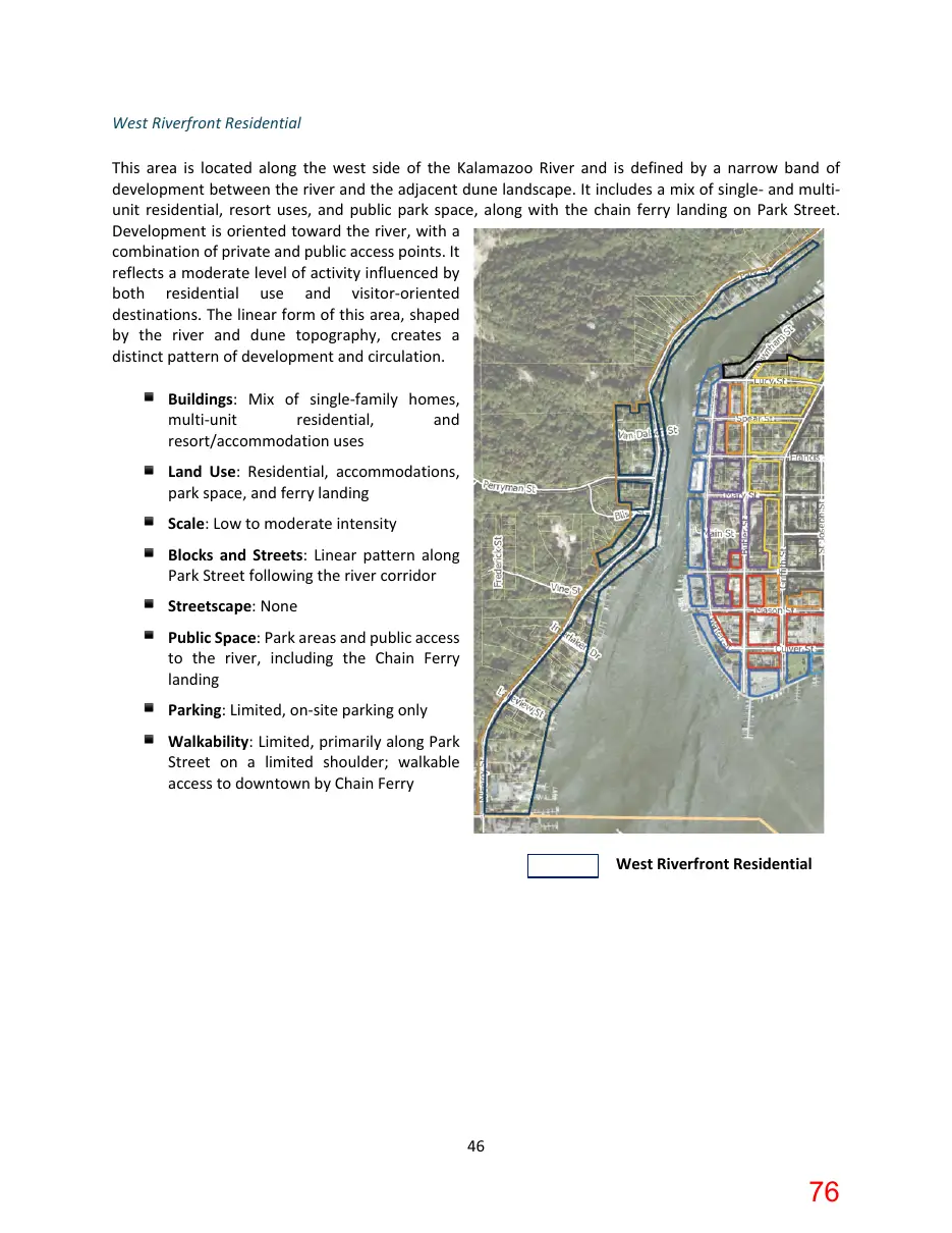
Text of page 76
West Riverfront Residential This area is located along the west side of the Kalamazoo River and is defined by a narrow band of development between the river and the adjacent dune landscape. It includes a mix of singleand multiunit residential, resort uses, and public park space, along with the chain ferry landing on Park Street. Development is oriented toward the river, with a combination of private and public access points. It reflects a moderate level of activity influenced by both residential use and visitor-oriented destinations. The linear form of this area, shaped by the river and dune topography, creates a distinct pattern of development and circulation. ▪ Buildings: Mix of single-family homes, multi-unit residential, and resort/accommodation uses ▪ Land Use: Residential, accommodations, park space, and ferry landing ▪ Scale: Low to moderate intensity ▪ Blocks and Streets: Linear pattern along Park Street following the river corridor ▪ Streetscape: None ▪ Public Space: Park areas and public access to the river, including the Chain Ferry landing ▪ Parking: Limited, on-site parking only ▪ Walkability: Limited, primarily along Park Street on a limited shoulder; walkable access to downtown by Chain Ferry
West Riverfront Residential
Page 77
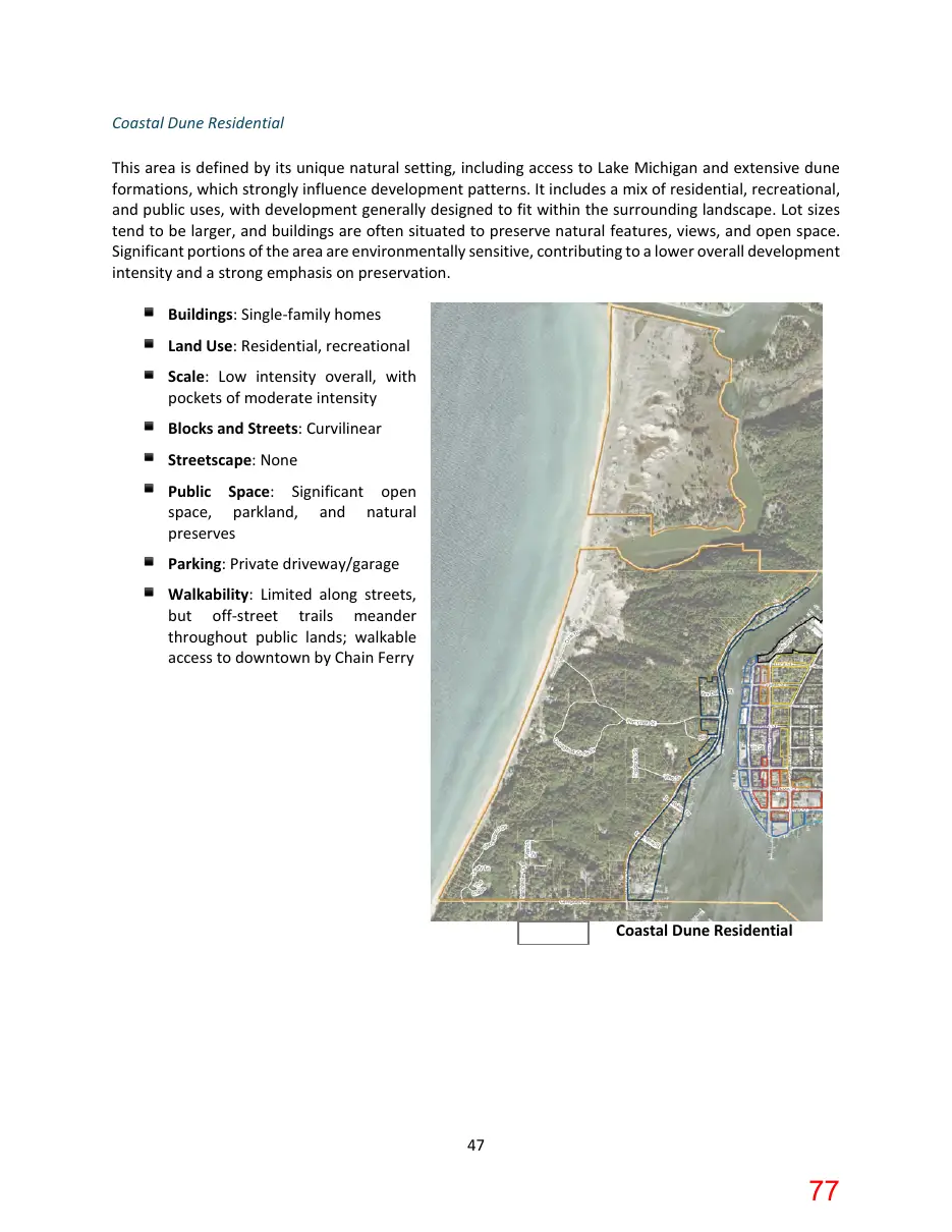
Text of page 77
Coastal Dune Residential This area is defined by its unique natural setting, including access to Lake Michigan and extensive dune formations, which strongly influence development patterns. It includes a mix of residential, recreational, and public uses, with development generally designed to fit within the surrounding landscape. Lot sizes tend to be larger, and buildings are often situated to preserve natural features, views, and open space. Significant portions of the area are environmentally sensitive, contributing to a lower overall development intensity and a strong emphasis on preservation. ▪ Buildings: Single-family homes ▪ Land Use: Residential, recreational ▪ Scale: Low intensity overall, with pockets of moderate intensity ▪ Blocks and Streets: Curvilinear ▪ Streetscape: None ▪ Public Space: Significant open space, parkland, and natural preserves ▪ Parking: Private driveway/garage ▪ Walkability: Limited along streets, but off-street trails meander throughout public lands; walkable access to downtown by Chain Ferry
Coastal Dune Residential
Page 78
Text of page 78
Existing Land Use An existing land use map illustrates the current use of land based on property classifications from the assessor's office. While these classifications are relatively broad and limited to general categories such as residential, commercial, industrial, parks, and open space, the map provides an important overview of existing development patterns. In particular, it identifies the boundaries between residential and nonresidential areas, which help inform future land-use designations and zoning decisions. Unlike the character analysis, the existing land use map focuses solely on current land use. It does not reflect the broader physical, historic, or functional characteristics that distinguish individual neighborhoods and planning areas. As it relates to future land use planning, recognizing the existing land use map does not necessarily mean that future land use or zoning should mirror the existing land use map. Rather, understanding existing conditions helps identify where change may be appropriate and where future land use designations may differ from current development patterns. This will help assess the impact and the extent of future change.
Urban Design and Sense of Place Small-Town Community Character The City of Saugatuck is characterized by a compact, walkable downtown with a high concentration of commercial activity, tourism destinations, civic uses, and direct access to the waterfront. Beyond the central city area, neighborhoods on the east side of the Kalamazoo River include a range of residential patterns, from traditional grid neighborhoods to more suburban and rural layouts influenced by natural land patterns. To the west of the Kalamazoo River, the City's coastal dunes, waterfront, and protected natural areas further define its character, with residential areas significantly influenced by environmental characteristics of the land. Although these three areas are unique, they each contribute to the City’s sense of place. The community survey found that Saugatuck's small-town character is the primary reason residents choose to live in the City, cited by 59.81% (189 of 316) of respondents. When asked what defines that small-town character, 57.27% (193 of 337) of participants identified the walkable downtown, 37.39% (126 of 337) identified the availability of locally owned businesses, and 31.75% (107 of 337) identified the city's arts and cultural offerings as the most important characteristics.
Building Form Based on the character analysis, the City’s building form is defined by a progression from a compact, traditional downtown to lower-density residential neighborhoods and environmentally sensitive waterfront and dune development. The downtown is characterized by oneand two-story traditional commercial buildings located close to the street, often attached or separated by only narrow gaps, creating a continuous street wall and a strong pedestrian environment. While storefront buildings 48
Page 79
Text of page 79
dominate the core, house-scale commercial buildings are also interspersed throughout the downtown, contributing to its eclectic character. Moving away from the downtown, the building form transitions to smaller-scale residential and mixeduse development. Neighborhood commercial areas often occupy former homes or other house-scale buildings. In contrast, surrounding neighborhoods consist primarily of oneto two-and-a-half-story singlefamily homes, with limited areas of attached or multi-unit housing. Building intensity generally decreases with distance from the downtown and the Lake Street Corridor. Building form is also strongly influenced by the city's natural setting. Along the waterfront, buildings are oriented to maximize river and lake access and views, while development within the coastal dune and hillside areas is adapted to topography, larger lot sizes, wooded landscapes, and environmentally sensitive dune systems. These areas feature a more dispersed development pattern with buildings designed to fit within the natural landscape and preserve open space and natural features.
Public Spaces Public spaces are fundamental to Saugatuck's identity and are among the community's defining assets. Parks, waterfront areas, civic spaces, and public gathering places establish the physical framework of the City while creating opportunities for recreation, community events, cultural expression, and everyday social interaction. These spaces connect residents and visitors and to the City itself, reinforcing Saugatuck's distinctive sense of place. Public spaces also serve as the setting for many of Saugatuck's signature community events and are essential to the City's civic life. Throughout the year, these spaces accommodate festivals, art fairs, outdoor concerts, farmers markets, parades, races, holiday celebrations, and waterfront events that attract both residents and visitors. Longstanding traditions such as the Venetian Festival, Fourth of July celebrations, Music in the Park, the Saugatuck-Douglas Art Club Art Fairs, and the Town Crier Races reinforce Saugatuck's identity as a vibrant waterfront and arts community while supporting local businesses, tourism, and community pride. The City's public realm also reflects its longstanding reputation as Michigan's "Art Coast." Public art, murals, sculptures, galleries, and cultural destinations extend beyond individual buildings to become part of the everyday public experience. Art is integrated throughout parks, streetscapes, and waterfront spaces, reinforcing community identity and contributing to the distinctive character that has become synonymous with Saugatuck. Public spaces also provide opportunities to experience and interpret the City's history. The SaugatuckDouglas History Center's History Lives Here program places interpretive markers throughout the community, integrating local history into the public realm and strengthening the connection between Saugatuck's physical environment and its cultural heritage. As Saugatuck continues to evolve, public spaces should remain a central focus of future planning and public investment.
Page 80
Text of page 80
Transitional Areas As identified in the Character Analysis, the City's primary transitional areas are located along Butler Street north of the Central Downtown Activity Center, north of Mason Street to the east and north of the downtown core, and along the east side of Lake Street. These areas provide an important transition between the more intense commercial and mixed-use downtown and the City's established residential neighborhoods. While predominantly residential in character, they typically accommodate a broader range of housing types, limited accommodation uses, and select neighborhood-scale non-residential uses. Buildings generally maintain a residential scale and form, while development patterns reflect a gradual transition from the activity and intensity of downtown to quieter residential settings, all within convenient walking distance of the downtown core. These transitional areas represent one of the City's most important planning considerations. Their location and existing mix of uses present opportunities to accommodate a greater variety of housing types and limited neighborhood-serving commercial uses while maintaining compatibility with adjacent residential neighborhoods. A primary focus of the Comprehensive Plan is to evaluate the appropriate extent of these transitional areas and establish future land use recommendations that define where transitional uses should occur and what development characteristics are necessary to create a compatible transition between the downtown and surrounding residential neighborhoods.
Gateways Gateways are the "welcome mat" to the community. At their simplest, they are the primary routes into the City for drivers, cyclists, and pedestrians. However, gateways are more than the physical infrastructure leading into the community or municipal boundaries; they are the points where visitors begin to experience the City's character and sense of place. The City's primary gateways include the intersections of Blue Star Highway and Lake Street, and Holland Street, North Street, and Riverside Drive, as these locations serve as the primary entry points into Saugatuck. An effective gateway signals that one has arrived at a destination distinct from the area through which one has traveled. Gateway planning incorporates many of the elements addressed throughout this chapter and others, including community branding, wayfinding signage, streetscape improvements, and the relationship between the City and its neighboring communities. In addition to the transportation infrastructure itself, signage, landscaping, lighting, and streetscape enhancements are key gateway-defining elements. For instance, the “palette sign” is a cherished gateway element at the intersection of Blue Star Highway and Lake Street. This sign and its associated landscaping define a primary gateway to the City. This type of gateway more effectively creates a sense of place than secondary gateways, which are more typically indicated by “city limits” signage. Additionally, high school sports championship signage, such as that at the Holland Street gateway, helps create a sense of community pride and school spirit. The relationship between the City of Saugatuck and its tri-community neighbors is also an important factor to consider, as gateways impact both directions. A community has little, if any, control over land use and infrastructure decisions that abut its gateway areas. This is why the spirit of tri-community planning and regional cooperation is a key theme of the overall comprehensive planning effort. 50
Page 81
Text of page 81
Wayfinding Wayfinding is a coordinated system of physical and digital tools that helps visitors navigate the community and also extends the City’s branding and marketing efforts. Further, meaningful wayfinding initiatives weave historic, cultural, community, and business assets into the overall strategy to accommodate and improve the visitor experience. Wayfinding can include directional, informational, and interpretative signage throughout the City, as well as digital platforms such as websites and smartphone applications. An April 2026 report by Walker Consultants, commissioned by the City, outlines current conditions and recommended improvements. The evaluation found that the City’s existing wayfinding and parking system lacks consistency and clear communication, making it difficult for visitors to locate public parking, understand parking regulations, and navigate between parking areas and downtown destinations. The report recommends implementing a coordinated wayfinding system with improved gateway features, directional signage, parking lot identification, pedestrian maps, consistent branding, and enhanced online and printed information to better communicate parking locations, transportation options, and downtown destinations. Aligned with the report’s evaluation, the majority of participants (52.15%) were unsure or felt that pedestrian sidewalk wayfinding signs are not attractive and conveniently placed throughout the community (145 of 278). However, most participants (70%) felt that the City’s gateway signs are attractive and representative of the community (194 of 277). The same number felt that historic signs in the City are truly representative of the community’s history and culture (194 of 278). Building on the positive perspectives regarding gateway and historic signage, efforts to improve pedestrian-level signage and directional signage for drivers would improve the overall navigability of the City. Additionally, while the 2026 report mainly focused on parking, wayfinding efforts can also reinforce the City’s sense of place, provide educational opportunities, and support tourism and economic development efforts.
Historic Preservation Historic Character Saugatuck's historic character is one of the community's defining assets and plays a central role in its small-town identity, tourism economy, and quality of life. The City's historic waterfront, downtown, and surrounding neighborhoods reflect generations of maritime activity, commercial development, arts and culture, and residential growth. Preserving these historic resources helps maintain the unique sense of place that distinguishes Saugatuck while supporting continued investment and economic vitality. The community survey indicated strong support for preserving Saugatuck's character. Almost 87% (247 of 284) of participants agreed that preserving existing neighborhood character should be a top priority, and approximately 73% (205 of 282) of participants supported ensuring that new homes are compatible with 51
Page 82
Text of page 82
the scale of surrounding neighborhoods. Survey participants also expressed strong support for maintaining the character of the downtown and commercial areas, with nearly 80% (244 of 307) indicating that it is important or essential for new and renovated commercial buildings to be designed in a manner consistent with the existing character of the area.
Historic District The Saugatuck Historic District was established in 1981 following a community-led effort to protect the City's traditional character from inappropriate development and redevelopment. The designation includes the downtown area, generally between the waterfront to the west, Lucy Street to the north, Griffith Street to the east, and Kalamazoo Lake to the south. However, several blocks are included north of Lucy Street along Holland Street and Simonson Drive, and south along Lake Street to Blue Star Highway. The Historic District designation was approved through local and state review processes and reflects the community's longstanding commitment to preserving its architectural, cultural, and historical heritage. The purpose of the Historic District is to protect the City's historic resources while ensuring that new construction, additions, alterations, and demolition are compatible with the historic character of the district, in addition to the following public purpose statements: ● ● ● ● ●
Safeguard the heritage of the City of Saugatuck by ensuring that the Historic District continues to reflect its architecture, archaeology, engineering, culture, local village character, and contextual aesthetic. Stabilize and improve property values within the Historic District and surrounding areas. Foster civic beauty. Strengthen the local economy. Promote the Historic District for the education, pleasure, and welfare of the City, county, state, and country.
While respondents strongly supported preservation, there was less support for expanding the Historic District to place additional restrictions on redevelopment and new development outside of the existing boundaries. Just over 41% (118 of 286) strongly agreed or somewhat agreed with expansion, 16% (47 of 286) were unsure, and 42% (121 of 286) disagreed.
Historic Resources The City administers a Certificate of Appropriateness review process for exterior work within the Historic District for both contributing and non-contributing resources. Proposed projects are evaluated using the Secretary of the Interior's Standards for Rehabilitation together with the City's Historic District Design Guidelines. These standards encourage the preservation of historic materials and architectural features while allowing reasonable adaptation and compatible contemporary design where appropriate.
Page 83
Text of page 83
Contributing resources are those which are mostly over 50 years old, have the original design mostly intact and the original design can be discerned and is capable of yielding important information about the period of significance. Non-contributing resources can be less than 50 years old or more than 50 years old, but the resource does not add to the historic architectural qualities of the period of significance due to significant alterations, disturbances or additions.
Conclusion As the City plans for the future, this chapter should serve as the basis for evaluating growth, redevelopment, public investment, and updates to zoning and development regulations. While change is both expected and necessary, it should reinforce the qualities that residents and visitors value most, ensuring that future development is compatible with the City's historic character, small-town identity, walkable environment, and exceptional natural setting. The Future Land Use chapter, among other chapters, builds upon this foundation by identifying where and how change should occur to achieve the community's long-term vision.
Planning Principles 1. Respect Community Character. Consider the Community Character Analysis as a foundational element of future land use planning and ensure that development and redevelopment are compatible with the established character of the City's downtown, neighborhoods, waterfront, and natural areas. Recognize that community character will evolve over time, but preserve the qualities that define Saugatuck's sense of place. 2. Consider Existing Conditions. Recognize existing neighborhood patterns, infrastructure, natural features, environmental constraints, and existing land use when making future land use and development decisions. Understand that future land use and zoning need not mirror existing land use, but should thoughtfully identify where change is appropriate and where existing character should be preserved. 3. Incorporate Character into Development Standards. Update zoning and development regulations to incorporate design elements that reinforce Saugatuck's small-town character, including building orientation, streetscape, pedestrian environment, building form, and site design. 4. Promote Compatible Building Form. Ensure that the scale, massing, height, and overall building form of new development are compatible with surrounding development and provide appropriate transitions between areas of differing intensity. 53
Page 84
Text of page 84
5. Embrace Public Spaces. Preserve, enhance, and expand Saugatuck's network of public spaces as defining community assets that support recreation, civic life, cultural expression, historic preservation, public access to the waterfront, and community gathering while reinforcing the City's distinctive identity and sense of place. 6. Strengthen Transitional Areas. Plan for transitional areas that provide a compatible transition between downtown commercial districts and established residential neighborhoods. Encourage an appropriate mix of residential and limited neighborhood-serving non-residential uses while managing building scale, intensity, and site design to protect adjacent residential areas. 7. Enhance Community Gateways. Strengthen gateway corridors and entry points through coordinated signage, landscaping, lighting, streetscape improvements, public art, and other design elements that establish a distinct identity and reinforce the City's sense of place. 8. Promote Regional Gateway Coordination. Coordinate gateway planning and improvements with neighboring jurisdictions to reinforce a consistent tri-community identity while recognizing the unique character of each community. 9. Improve Wayfinding. Continue implementing a coordinated wayfinding program that combines physical signage, maps, parking information, interpretive features, and digital tools to improve navigation while reinforcing community branding and visitor experience. 10. Preserve Historic Resources. Continue to support the Historic District and historic preservation efforts by protecting historic resources, maintaining the public purposes of the Historic District, and ensuring that new construction and redevelopment are compatible with the City's historic character.