
Workshop Agenda item 5F
Resolution No. 250324-B: A Resolution Providing City Council’s Public Comment to the United States Army Corps of Engineers on Northshore of Saugatuck, LLC’s Permit to Build a Boat Launch
City Council Workshop, Wednesday, March 19, 2025
Download these 23 pages, 1.1 MB Whole packet, 79 pages, 3.9 MB
Page 37
Text of page 37
City Council Agenda Item Report FROM:
Ryan Cummins, City Manager
MEETING DATE:
March 19, 2025
SUBJECT:
Resolution No. ___ - A Resolution Providing City Council’s Public Comment to the United States Army Corps of Engineers on Northshore of Saugatuck, LLC’s Permit to Build a Boat Launch
DESCRIPTION: At the February 19 workshop, Council reviewed a request from the Saugatuck Dunes Coastal Alliance (Coastal Alliance) that the City provide comments via resolution and/or letter to the Army Corps of Engineers related to an application by North Shores of Saugatuck LLC, for a permit to install a boat ramp in the Kalamazoo River. Saugatuck Township advised they will not be submitting comments as they view this as an improvement of an existing piece of infrastructure that is for private use and the Township defers to EGLE for decisions on launch permits. The Michigan Environment, Great Lakes, and Energy is considering the request and conducted a public hearing last summer. The video of the hearing can be viewed here: https://www.youtube.com/watch?v=C4X8U6lA_TM Council requested that a resolution be drafted that opposes the proposed ramp. Attached is a draft resolution for Council consideration. BUDGET ACTION: None at this time. LEGAL REVIEW: Legal prepared the draft resolution and will be at your meeting for any questions. SAMPLE MOTION:
Page 38

Text of page 38
Motion to approve Resolution No. ___ - A Resolution Providing City Council’s Public Comment to the United States Army Corps of Engineers on Northshore of Saugatuck, LLC’s Permit to Build a Boat Launch
Page 39
Text of page 39
CITY OF SAUGATUCK COUNTY OF ALLEGAN STATE OF MICHIGAN RESOLUTION NO. ______ A RESOLUTION PROVIDING CITY COUNCIL’S PUBLIC COMMENT TO THE UNITED STATES ARMY CORPS OF ENGINEERS ON NORTHSHORE OF SAUGATUCK, LLC’S PERMIT TO BUILD A BOAT LAUNCH Council Member _____________ offered the following resolution and moved for its adoption, seconded by Council Member ___________________. WHEREAS, NorthShore of Saugatuck, LLC has applied for a United States Army Corps of Engineers (the “USACE”) permit (with USACE review file no. LRE-201000304-52-N24) under Section 10 of the Rivers and Harbors Act of 1899 and Section 404 of the Clean Water Act to build a permanent boat launch located in the Kalamazoo River, near the mouth of the Kalamazoo in Saugatuck Township (the “Township”), Michigan. WHEREAS, the site is located upland at 3574 Dugout Road and 6500 135th Avenue, Allegan County, Michigan 49453. WHEREAS, the City’s jurisdictional boundaries, including its jurisdiction and control over the Kalamazoo River that exists within the City’s boundaries, is near to the proposed boat launch. WHEREAS, the City further owns extensive acreage held as public lands with substantial frontage on the Kalamazoo River that is directly south of the proposed boat launch. WHEREAS, NorthShore of Saugatuck, LLC previously applied for a USACE (review file no. LRE-2010-00304-52-517-2) and Michigan Department of Environmental and Great Lakes (“EGLE”) (EGLE Submission Number HPF-78A-RGC7Q) permit for the construction of a marina basin in the same location, both of which were denied in February 2024. WHEREAS, the proposed boat launch is one component of NorthShore of Saugatuck, LLC’s larger development project, that once included the rejected marina basin project, and is posed to bring significant impacts to the Kalamazoo River Mouth area. WHEREAS, the City opposes the proposed boat launch for similar reasons it opposed the marina basin project, and reiterates those concerns below. WHEREAS, the adverse impacts associated with the boat launch are similar and are likely to exceed those associated with the marina basin project.
Page 40
Text of page 40
WHEREAS, the City has interests, as reflected below, that are impacted by developments in the area, including the City’s interests as a fiduciary in holding public lands in trust for its community and representing the general interests of the public within the City. WHEREAS, the USACE is required to take into account the effects of proposed undertakings on historic properties both within and beyond waters of the United States. WHEREAS, the USACE provided further Public Notice on December 3, 2024, specifically regarding Section 106 to seek input on historic properties issues regarding the subject application pursuant to Section 106 of the National Historic Preservation Act and pursuant to 33 CFR 325, Appendix C. WHEREAS, in response to the Public Notice and the understanding that the USACE will still consider public comment as part of the open application, City Council desires to provide public comment on the pending application and stress the importance of the USACE to carefully review and weigh the public interest factors as well as historic preservation of the historic and cultural history at and around the proposed location as set forth below. NOW, THEREFORE, BE IT RESOLVED AS FOLLOWS: 1. In its evaluation of permit applications, the USACE will conduct a public interest review in which “due consideration shall be given to” a “local agency having jurisdiction or interest over the particular activity” and the USACE will consider “those official views as a reflection of local factors of the public interest.” 1 2. It is true that “[w]hen private enterprise makes application for a permit, it will generally be assumed that appropriate economic evaluations have been completed, the proposal is economically viable, and is needed in the market place. However, the district engineer in appropriate cases, may make an independent review of the need for the project from the perspective of the overall public interest” (emphasis added). 2 3. In every application, the USACE will consider “[t]he extent and permanence of the beneficial and/or detrimental effects which the proposed structure or work is likely to have on the public and private uses to which the area is suited.” 3 4. With regard to “other Federal, state, or local requirements,” “where the required Federal, state and/or local authorization and/or certification has been denied for activities which also require a Department of the Army permit before final action has been taken on the Army permit application, the district engineer will, after considering the likelihood of subsequent approval of the other authorization and/or certification and 1
33 CFR § 320.4. Id. 3 Id. 2
Page 41
Text of page 41
the time and effort remaining to complete processing the Army permit application, either immediately deny the Army permit without prejudice or continue processing the application to a conclusion. If the district engineer continues processing the application, he will conclude by either denying the permit as contrary to the public interest, or denying it without prejudice indicating that except for the other Federal state or local denial the Army permit could, under appropriate conditions, be issued.” 4 5. The City, as a “local agency having jurisdiction or interest over the particular activity,” finds that the proposed excavation to build a boat launch within the Critical Dune Area adjacent to the Kalamazoo River appears “contrary to the public interest.” 6. The City finds that the cumulative, permanent detrimental impacts of the excavation and construction of the proposed boat launch on the Tri-Community tourist-based economy (City of Saugatuck, City of the Village of Douglas, and Saugatuck Township) far outweigh any possible economic benefit. The City therefore questions that the boat launch is clearly “needed in the market place.” 7. The City finds that the Tri-Community tourist-based economy relies on the preservation of the historical, ecological, and cultural values in the river mouth area, which appear will be impacted by the proposed boat launch. 8. The City finds that the proposed boat launch has the potential of impacting wellestablished “public and private uses to which the area is suited,” including public lands held by governmental agencies to the north and south of the proposed boat launch. 9. With regard to “other Federal, state, or local requirements,” the City only notes that litigation continues between the Saugatuck Dunes Coastal Alliance and Saugatuck Township regarding local approvals related to the boat launch. THE PROPOSED BOAT LAUNCH IS INCONSISTENT WITH PAST AND CURRENT USES OF THE KALAMAZOO RIVER MOUTH AREA 10. USACE’s assumption in its December 3, 2024, letter to consulting parties that the primary use of the site is a marina is misguided. 11. The proposed boat launch will diminish the aesthetic of the surrounding landscape, the purpose of which is to preserve history, nature and recreation, while promoting the local tourism industry. 12. The proposed boat launch is inconsistent with past and current uses of the River Mouth Area, including Broward Marine’s use of the site as a boat lift. 13. Broward Marine was issued a Special Land Use Variance on April 27, 1977, the company utilized the site to launch its newly manufactured boats. 4
Id.
Page 42
Text of page 42
14. Broward Marine utilized the site for a total of 27 years and ceased launching boats in 2004. 15. The claim that the site is currently used as a gravel launch is misplaced, instead, the site had previously housed a boat lift to launch Broward Marine’s newly manufactured boats. 16. On average, Broward Marine launched three boats per year during its use of the site (1977-2004), which is inconsistent with the proposed high intensity boat launch, described below. OPERATIONAL AND SAFETY CONCERNS: THE PROPOSED PROJECT WILL HAVE AN ADVERSE EFFECT ON THE SAFETY AND NAVIGABILITY OF THE KALAMAZOO RIVER MOUTH 17. The proposed boat launch is a part of Northshore LLC’s larger development project, that has resulted in the construction of over 65 boat storage units, each capable of housing several large boats. 18. Based on the above, the proposed boat launch could service more than 100 boats each year, double that of what was contemplated in Northshore LLC’s rejected marina basin project. 19. The proposed boat launch site is located at a section of the Kalamazoo River Mouth that already poses significant navigational difficulties and is regularly used by the Star of Saugatuck boat tours. 20. The Kalamazoo River Mouth area is vulnerable to adverse weather events that, if coupled with an increase in marine traffic and navigability issues that would arise from the proposed boat launch, would significantly increase the likelihood of an accident and would pose an unacceptable risk to public safety. 21. The Kalamazoo River Mouth is also unsuited for boats to loiter while waiting to use the proposed boat launch, such that the “stacking” of boats waiting to use the launch would exponentially increase the chances of an accident beyond the other factors mentioned here. 22. The proposed boat launch does not include the requisite support infrastructure, including available parking areas for motor vehicles and boat trailers, to sustain the orderly operation of a high intensity boat launch and will negatively impact the public peace. 23. The City finds the proposed boat launch will have an adverse effect on the safety and navigability of the Kalamazoo River Mouth area due to a significant and unsustainable increase in marine traffic.
Page 43
Text of page 43
HISTORY OF THE TRI-COMMUNITIES’ VALUES AND TOURIST ECONOMY: THE BOAT LAUNCH IS “CONTRARY TO THE PUBLIC INTEREST” AND NOT “NEEDED IN THE MARKET PLACE” 24. The Tri-Communities have a 137-year history of deliberately building a tourist-based economy centered on the preservation and conservation of public open space in the river mouth area. 25. In 1884, the Village of Saugatuck—the former governmental entity prior to incorporation of the Village into the now City of Saugatuck—purchased Mount Baldhead and the lake frontage to the west. The lake frontage would eventually become Oval Beach. Stairs up the east side of the dune and a pavilion at the bottom were built to attract tourists to the area. 26. In 1920, Thomas Eddy Tallmadge purchased 105 acres of forested dunes surrounding the Ox-Bow School of Art. To protect the school and land, Tallmadge made arrangements with the City to preserve the land as green space in times the school did not operate. 27. In 1936, the City opened Oval Beach. 28. In 1957, the National Park Service conducted a survey of potential park sites along Lake Michigan. The Park Service wrote in its study: “[b]y virtue of its fine beaches (Oval Beach) and scenic hinterlands, Saugatuck has a high public use value. . . . Immediate steps should be taken to safeguard these values in order to meet the recreation demands of this region” (emphasis added). 29. Between 1977 and 1988, local citizens worked to establish Saugatuck Dunes State Park and Natural Area. 30. In 1977, the Natural Areas Conservancy of West Michigan (“NACOWMI”) acquired a 300-acre parcel, known as the Luther-Uhl property, which was adjacent to what would become the Saugatuck Dunes State Park. 31. Around this time, the State acquired 550 acres from the Augustinian Seminary. It kept 40 acres of this land for the operation of a prison and gave the remainder of the land to the Department of Natural Resources (“DNR”). 32. Following its acquisition of the land, it advocated for the Luther-Uhl land to be protected as a natural area for scientific study. 33. Following this, the DNR announced its state park plan which called for a 1,500-car parking lot on the beach and an off-road vehicle area. The local response was immediate and unanimously negative.
Page 44
Text of page 44
34. The DNR withdrew its state park plan and allowed for the formation of a citizen’s advisory committee to draft a master plan for Saugatuck Dunes State Park. This was the first time a citizen’s advisory committee was entrusted to create a State Park Master Plan. 35. Patty Birkholz, a Parks Commissioner from the Township, was appointed Chair of the committee. 36. The committee’s Master Plan called for a low-impact nature study and prohibited overnight camping—a rare prohibition in the state park system. 37. The Master Plan included detailed expansion plans for acquiring, among other lands, those around the proposed boat launch, including the NorthShore of Saugatuck property. These plans called for an expanded natural area and designated historic site where the buried ghost town of Singapore lies. 38. The Master Plan required the Luther-Uhl property to be legally designated as a Natural Area. 39. The citizens charged with drafting the Master Plan worked with the conservancy community, the DNR, and the State for six years to ensure the protection of the land. In 1982, the Master Plan was unanimously approved by the Natural Resources Commission. 40. In January 2004, the DNR received over 100 individual letters supporting a proposed expansion of the Saugatuck Dunes State Park to include the Denison property, which then became the Singapore Dunes LLC property and most recently became the NorthShore of Saugatuck property. 41. Between the years 2003 and 2005, the communities of the City of Saugatuck, the City of the Village of Douglas, and Saugatuck Township came together for a series of meetings to discuss and debate land use issues and future development. This meeting led to the publication of the 2005 Tri-Community Master Plan (the “2005 Master Plan”), which focused on protecting the historical, ecological, and cultural values that drive the tourist-based economy. 42. During this period of time, there were two townhall-style meetings, as well as the collection of data from a community survey. Almost every other resident in the community responded. 43. The 2005 Master Plan was unanimously approved by the City of Saugatuck, the City of the Village of Douglas, Saugatuck Township, and Allegan County. 44. To put the 2005 Master Plan into place, the municipalities took several actions towards protecting the natural areas.
Page 45
Text of page 45
45. In 2007, the Tri-Communities placed a conservative easement onto Tallmadge Woods Nature Preserve. 46. In 2009, the Tri-Communities assisted in the $20 million public acquisition of the Saugatuck Harbor Natural Area. A grant of $10.5 million from the Michigan Natural Resources Trust Fund was the largest public grant ever extended by this state fund. 47. In 2010, the City voters passed a millage to tax themselves for better support of the natural resources’ local zoning protections. 48. In 2010, local organizations applied to have the Wild Heart of Saugatuck, an area including the river mouth, added to the National Trust for Historic Preservation’s annual list of America’s 11 Most Endangered Places. 49. Lana Pollack, former Chair of the Michigan Natural Resources Trust Fund Board, submitted the following letter to the National Trust for Historic Preservation in support of the designation and opposed to Northshore LLC’s previous marina proposal, primarily in hopes of protecting the state’s investment: My own valuation of this area is best demonstrated by the recent MNRTF decision to grant $10.5 million to protect a portion of the land now representing a significant part of this application. The grant approved in December 2009 is one of the largest MNRTF has ever made and is a particularly impressive commitment given the intense competition from other worthy applicants that year. Support for the grant did not come easily, but not because of a questioned worth of the project – 171 acres of critical dunes with globally imperiled inter-dunal wetlands, habitat that is home to several threatened and endangered species. The project’s value was undoubtedly enhanced by its immediate proximity to Saugatuck’s Oval Beach, the Saugatuck Lighthouse Cottage and the Ox-Bow School of Art. Although MNRTF is focused on saving natural landscapes, we also recognized in this case the historic and cultural context of the particular 171 acres that our grant was supporting. The designation that we now seek from the National Trust for Historic Preservation is needed because of the threat of development on the parcel immediately north of the Saugatuck Harbor Natural Area. The current proposal calls for a major marina development with a suggested nine story hotel, restaurants, retail businesses as well as a 70 slip marina near the site of the buried ghost town of Singapore – all prohibited by current zoning. If completed, the proposed development’s impact on MNRTF’s investment of $10.5 million still leaves me concerned that our public investment may become mostly the enhanced viewscape for a commercial development.
Page 46
Text of page 46
Fortunately, the history of preservation of the Saugatuck Dunes is strong. In the 1940’s the State of Michigan looked at constructing a State Park at the mouth of the Kalamazoo River. In the 1950’s the National Park Service surveyed the Saugatuck Dunes for its potential as a National Lakeshore. In the 1980’s area citizens worked together to draft the Master Plan for the Saugatuck Dunes State Park and Natural Area. This followed the initial plan from the state DNR that called for paved roads and a parking plot on the beach, which was met with near unanimous resistance. Since that time several additional key parcels have been placed into conservation easements or turned into parks; historic buildings have been acquired by the local Historical Society; and progressive planning has established a Lakeshore Open Space District designed to better protect the historic and ecological treasures along the river and lakeshore. It was with this in mind – the long and determinedly fought history of protecting the Saugatuck Dunes – that I felt comfortable urging MNRTF to award the $10.5 million grant. The tenacious commitment of the local community to protect the Saugatuck Dunes’ many historic, cultural and ecological resources ultimately held more sway than the threat of a developer’s legal war chest to overturn protective zoning controls [emphasis added]. 50. In 2016, the updated Tri-Community Master Plan (the “2016 Master Plan”) was released. The priority among the Tri-Communities remains: “Public acquisition of the Denison property on both sides of the Kalamazoo River is the top priority for the TriCommunities.” 5 51. Today, the City owns nearly 16,000 feet of water frontage in the River Mouth Area immediately adjacent to the proposed boat launch. A portion of this is the Saugatuck Harbor Natural Area, a 177-acre designated natural area/sanctuary held under the supervision of the City. The Saugatuck Harbor Natural Area has 570 feet of water frontage on the Kalamazoo River and nearly 6,200 feet of water frontage on the Old Harbor. All of this water frontage is in its natural state and does not have seawalls or riprap. The City also manages the Tallmadge Woods Nature Preserve, a 100-acre preserve with 6,200 feet of Kalamazoo River frontage and 2,900 feet of Old Harbor water frontage. 52. The Saugatuck Harbor Natural Area and the Tallmadge Woods Nature Preserve connect with Saugatuck’s Oval Beach and Mount Baldhead Park, together comprising 415 acres of park land and natural areas. These areas are all managed as low-impact natural areas to ensure the protection of the ecological, historical, and cultural values that drive Saugatuck’s tourism-based economy. These areas are indispensable to the economic well-being of the City of Saugatuck, the City of the Village of Douglas, and Saugatuck Township (the “Tri-Communities”). 5
City of Saugatuck, et al., Tri-Community Master Plan 9-6 (2016).
Page 47
Text of page 47
53. The NorthShore of Saugatuck development and management may directly affect these natural areas and sanctuaries that the City manages for the benefit of the community. 54. Because of its effect on the low-impact natural areas and City-owned property, the NorthShore of Saugatuck development may have significant impacts on the TriCommunities’ tourist-based economy. 55. Among the goals listed in the 2016 Master Plan is the goal to “[p]rotect special environments and open spaces, including but not limited to sand dunes, wetlands, and critical wildlife habitat, from the harmful effects of incompatible development activity by limiting the type and intensity of land development in those areas.” 6 56. The 2016 Master Plan also outlines the goal to “[g]uide development in a manner which is orderly, consistent with the planned expansion of public facilities, and strives to preserve the scenic beauty, foster the wise use of natural resources, protect environmentally sensitive areas, and enhance the special character of the TriCommunities.” 7 57. The 2016 Master Plan states that “[t]hese joint goals and policies are premised on a pledge by Saugatuck Township, the City of Saugatuck, and the City of the Village of Douglas to mutually cooperate in guiding future development to advance a common vision. It is intended that these goals and policies be consulted when considering future land use decisions within an individual jurisdiction, as well as those decisions that affect the interests of more than one jurisdiction.” 8 58. The goals and policies in the 2016 Master Plan “are premised on a pledge by Saugatuck Township, the City of Saugatuck, and the City of the Village of Douglas to mutually cooperate in guiding future development to advance a common vision.” 9 59. The goals and policies outlined in the 2016 Master Plan and those outlined by the City here represent a “local agency having jurisdiction or interest over the particular activity” and should be considered “as a reflection of the local factors of the public interest.” 10 60. The 2016 Master Plan articulates the economic public interest in preserving the river mouth area of the Kalamazoo River for “low-impact development” or public open space. 11
City of Saugatuck, et al., Tri-Community Master Plan 1-12 (2016). Id. at 1-4. 8 Id. at 1-2. 9 Id. 10 33 CFR § 320.4(j)(1). 11 See, generally, City of Saugatuck, et al., Tri-Community Master Plan (2016). 7
Page 48
Text of page 48
61. The City considers the 2016 Master Plan to be “a reflection of local factors of the public interest.” The 2016 Master Plan states “[t]hese joint goals and policies are premised on a pledge by Saugatuck Township, the City of Saugatuck, and the City of the Village of Douglas to mutually cooperate in guiding future development to advance a common vision. It is intended that these goals and policies be consulted when considering future land use decisions within an individual jurisdiction, as well as those decisions that affect the interests of more than one jurisdiction.” 12 62. Specifically, the City considers the following 36 excerpts from the 2016 Master Plan to be “a reflection of local factors of the public interest”: a. “Goal: Guide development in a manner which is orderly, consistent with the planned expansion of public facilities, and strives to preserve the scenic beauty, foster the wise use of natural resources, protect environmentally sensitive areas, and enhance the special character of the Tri-Communities.” 13 b. “Policy: Insure compatible land use planning and zoning across municipal borders and minimize land use conflicts by separating incompatible uses and requiring buffers where necessary.” 14 c. “Policy: Support efforts to foster tourism by preserving the scenic beauty of the environment, expanding recreational opportunities, improving tourist attractions, preserving the historic character of the communities through the preservation of historic structures, expanding cultural and arts opportunities and encouraging development of promotional material which highlight the attractions of the Tri-Communities.” 15 d. “Goal: Encourage planning efforts based on the understanding, knowledge and respect for the Tri-Community’s historical and cultural resources.” 16 e. “Policy: Discourage the development of high intensity residential uses along the waterfront.” 17 f. “Goal: Protect special environments and open spaces, including but not limited to sand dunes, wetlands, and critical wildlife habitat, from the harmful effects of incompatible development activity by limiting the type and intensity of land development in those areas.” 18
Id. Id. at 1-4. 14 Id. at 1-5. 15 Id. at 1-6. 16 Id. at 1-10. 17 Id. at 1-12. 18 Id. 13
Page 49
Text of page 49
g. “Policy: Identify development limitations on special environments which classify environments based on their value to the ecosystem, unique attributes, the presence of endangered plant and wildlife species, and other characteristics deemed significant.” 19 h. “Policy: Encourage acquisition of special environments of significant public value by public agencies or nonprofit conservancy organizations for the purpose of preservation.” 20 i. “Policy: Prepare and maintain a subarea plan for the Oxbow Peninsula including the [NorthShore of Saugatuck Property] ‘Denison Property.’” 21 j. “Policy: Promote the preservation of open spaces and natural areas, as well as limited, carefully planned development along the Kalamazoo River, Kalamazoo Lake, Silver Lake, Goshorn Lake, and Lake Michigan and connecting streams, creeks, and drainage ways to protect and enhance the scenic beauty of these waterfront areas.” 22 k. “In 2002 the City of Saugatuck completed a strategic plan for purposes of future growth and development and efforts involved an examination of local tourism and public opinion. The following data was secured from the plan’s survey of visitors to the area, and provides useful information considered applicable to each of the Tri-Communities when considering economic and recreational impacts on the area. . . Activities – beach (40%), dune rides (12%), and boating (11%) Spending Patterns - $500 to $599 (median range), 15% spend +$1,000. . . .” 23 l. “The primary reasons people visit or live in the three communities are to enjoy the scenery and recreational opportunities and to live in a picturesque, safe place while they commute to nearby (or distant) urban centers. Beach recreation, boating and other water activities, shopping, art galleries and enjoying the scenery are the primary attractions for both tourists and year-around residents. While agriculture, industry and tourism are important economic sectors represented in the Tri-Communities, tourism is king” (emphasis added). 24
Id. Id. 21 Id. 22 Id. at 1-13. 23 Id. at 2-8. 24 Id. at 3-1. 20
Page 50
Text of page 50
m. “Mature trees represent a valuable resource in maintaining the aesthetic character of the area, not to mention their overall importance to wildlife and the natural environment. In particular, the wooded sand dunes along the Kalamazoo River and Lake Michigan, and those buffering adjacent uses from I-196, are especially important. They should be managed to insure their long term existence” (emphasis added). 25 n. “A large portion of the lakeshore both north and south of the mouth of the Kalamazoo River is undeveloped or very sparsely developed. A portion of this segment of the shoreline is in public ownership as Oval Beach Park. In 2011, the City of Saugatuck completed its acquisition of the 173 acres of natural dunes and 3,650 feet of undeveloped Lake Michigan Shoreline, formerly owned by the Denison family, between the south Kalamazoo River pier and Oval Beach City Park. This was made possibly through a partnership between the City; the Land Conservancy of West Michigan; a 10.5 million grant from the Michigan Natural Resources Trust Fund; The Nature Conservancy; The Conservation Fund; and generous private donors. The Saugatuck Harbor Natural Area, as it is now called, is open year round for low impact uses such as hiking, fishing, bird watching and beach combing.” 26 o. “The Tri-Community area is rich in cultural, and historical points of interest and many archaeological sites can be found throughout the area. Leading economists and forward-thinking governmental leaders have recognized the social and economic value of promoting and preserving cultural and historic assets. The state of Michigan has made community cultural; planning a key part of its most publicized and marketed economic development strategies: the ‘smart growth’; ‘heritage/cultural tourism’; and ‘cool cities’ initiatives.” 27 p. “Archaeological sites are of particular scientific value to the fields of anthropology, ecology and biology, and may have historic or ethnic significance as well. There are 120 archaeological sites scattered throughout the Tri-Community area, mostly related to Ottawa and Potawatomi cultures. Their exact locations have not been disclosed by the Bureau of history to protect them from exploitation. One of these sites, the Hacklander Site, located in Section 23 is listed on the National Register of Historic Places and has components representing Middle and Late Woodland periods. A second important site is the old Singapore site located at the north edge of the ‘new’ (1906) harbor channel. Recipients of Federal assistance must ensure that their projects avoid damage or destruction of significant historical and archaeological resources. The Michigan Bureau of History reviews these projects to assess their impact on archaeological sites” (emphasis added). 28 25
Id. at 4-23. Id. at 5-7. 27 Id. at 5-9. 28 Id. at 5-11. 26
Page 51
Text of page 51
q. “Parks, recreation, and open space are essential to the quality of life of area residents, and are an important component of the local tourist economy. They enhance property values, as well as physical and psychological well-being.” 29 r. “According to the 2004 community opinion survey, following was the response to the question of whether the respondent would support the additional recreation-related activities even if it meant an increase in general property taxes. . . . The greatest support among recreation-related topics was for better water quality with 62.5%, bike lanes/pathways with 60.5% support and parks and recreation at 50.9%. When citizens express a willingness to pay higher taxes for a service that is very significant” (emphasis added). 30 s. “Recreation is important to the Tri-Communities and the visual experience of the community is tied to the recreational experience. Residents like to live in the Tri-Communities, in part, because it is a uniquely attractive location. Tourists visit and spend money in the Tri-Communities based in part on the visual experience. Natural features and open spaces are important components of the Tri-Communities, contrasting with the concentrated, developed areas of the City of Saugatuck and the City of the Village of Douglas. The compact, strong identities of the City and Village are enhanced when natural, open spaces surround the two communities. Water is one of the natural features surrounding the City and Village and helping to give them form and identity. Wetlands, woodlands, farms and parks are other existing natural features that currently contribute to natural open space.” 31 t. “Tourists have always been attracted to the area, but tourism is now the number one economic activity. . . . Consequently, how the waterfront is used will be of crucial importance to the future of the Tri-Community area.” 32 u. “Although waterfront lands have high revenue generating potential, a major attraction of both the Lake Michigan and Kalamazoo River waterfronts is their scenic, natural shorelines composed of forested sand dunes and large wetland areas. Should these natural areas be greatly damaged or destroyed through inappropriate development, then the ‘goose that laid the golden egg’ will be dead. It is essential that the natural beauty of the waterfront be maintained along the Lake Michigan shoreline, the Kalamazoo River from the channel to Saugatuck, and from the Blue Star Highway Bridge inland” (emphasis added). 33
Id. at 7-1. Id. at 7-18. 31 Id. 32 Id. at 8-1. 33 Id. at 8-1 through 8-2. 30
Page 52
Text of page 52
v. “This plan seeks to define a balance between competing uses. It places protection of the natural environment at first and foremost in making future land use decisions along the Lake Michigan and Kalamazoo River waterfronts. The ultimate goal is to minimize disruption of the natural environment so that new development and redevelopment is in harmony with the environment, rather than in conflict with it. Alteration of existing natural features should be very limited, and with mitigation to provide the same values and functions nearby.”34 w. “Under the state Wilderness, Wild, and Natural Areas Program (Part 351 of the Natural Resources and Environmental Protection Act of 1994), the DNR is charged with identifying, dedicating and administering wilderness, wild and natural areas. Within the Saugatuck region, the DNR has dedicated the Saugatuck Dunes Natural Area to protect the unique dune ecosystem of open dunes, blowouts, interdunal wetlands and wooded dunes, Pitcher’s Thistle occurs with in the area and is listed as a threatened species by both the state and federal government. The Saugatuck Dunes Natural Area is within Saugatuck Dunes State Park. Sensitive dune ecosystems also occur in the dune areas on either side of the Kalamazoo River mouth at Lake Michigan. This area is planned for protection but details have yet to be finalized. Management would likely be the responsibility of the City of Saugatuck, Saugatuck Township and the State Park. The entire Kalamazoo River, including the Saugatuck/Douglas area is designated as an area of particular concern by the DNR. Areas of particular concern are those having scarce resources, unusual scenic beauty, unusual economic value, recreational attractions, or some combination of the above. They are only located in coastal areas. Altering the environment in an area of ‘particular concern’ could have a significant impact on the quality of coastal and Great Lakes waters.” 35 x. “As has been emphasized throughout this Plan, the natural beauty of the waterfront has much to do with the attraction of the Tri-Community area” (emphasis added). 36 y. “Several vistas have public values that deserve protection. These include the entry into and exit from Lake Michigan on the Kalamazoo River, the view from Mount Baldhead, the view of Kalamazoo Lake from both ends, and approaches to the Kalamazoo River Bridge” (emphasis added). 37 z. “In seeking to balance economic development with environmental protection, the concept of carrying capacity should be a major consideration. If the carrying capacity of land or water is exceeded, then activities cannot be undertaken without unacceptable impacts on users, the environment, or both. Impacts can 34
Id. at 8-2. Id. at 8-6. 36 Id. at 8-25 37 Id. 35
Page 53
Text of page 53
include increased trip times, decreased safety, pollution, loss of open space, and many other considerations. The key is prevention of overuse by limiting intensity of use on adjoining lands and regulating surface water use. Environmental protection must be a leading principle in making future land use decisions along the waterfront. Environmentally sensitive areas such as sand dunes, wetlands, high risk erosion areas, floodplains, and key woodlands should be protected from unnecessary destruction. Development should complement rather than destroy these areas and their values. By doing so the environmental quality of the air and water will be improved, wildlife habitat will be preserved, scenic values will be protected, and the character of the area will be maintained. Some new intensive shoreline development will be desirable and necessary, but the balance should not be disproportionately on the side of new tax base as it has been for the past three decades. Opportunities to enhance the waterfront should be seized. Parks and open spaces should eventually be linked with other public places.” 38 aa. “Protection mechanisms, like the Natural River designation, should be recognized for the ancillary benefits they bring to the community.” 39 bb. “Good land use planning is essential to the future quality of life in the TriCommunities. Actual future land uses are difficult to predict and guide to achieve desired results. A future land use map and plan expresses local and use goals and policies and provides a land use scenario which a community may use as a physical guide. Goals and policies, in turn, drive land use and development decisions.” 40 cc. “The following planning and design principles are the technical foundation in support of the proposed land use arrangements graphically depicted on the Future Land Use Map. These principles are consistent with the goals and policies in Chapter 1 and should remain the basis for reviewing any subsequent changes to the proposed Future Land Use Map. These planning principles are: • • • • • •
Protection of public health and safety Conservation of natural resources Environmental Protection Minimizing public service costs Efficiency and convenience in meeting land use needs Insuring compatibility between land uses” (emphasis added). 41
Id. at 8-25 through 8-26. Id. at 8-27. 40 Id. at 10-1. 41 Id. at 10-1. 39
Page 54
Text of page 54
dd. “Failure to consciously protect nonrenewable natural resources exposes a community to unbridled destruction of those resources which are the foundation for an area's character and quality of life. Conservation of natural resources usually focuses on: land, water, minerals, certain soils (such as prime farmland), wetlands, sand dunes, areas supporting an abundance and diversity of wildlife, and unique forested lands. Areas where the land and the water meet are the most important. Indiscriminate land subdivision frequently reduces the size or alters the shape of land, thereby compromising the resource value and production potential of those lands. This occurs frequently in prime agricultural areas and once lost, these lands may never be reclaimed for food production purposes.”42 ee. “This principle aims at preventing pollution, impairment or destruction of the environment. While there is considerable overlap with natural resource conservation issues, environmental protection measures focus primarily on air and water quality, and the impact of activities where the water meets the land. Environmental quality is best preserved by planning for appropriate land use activities in and near sensitive environmental areas, and managing development accordingly.” 43 ff. “A central objective of land use planning is to locate future land uses so that they are compatible with one another. This prevents future nuisance situations between adjacent land uses, such as loud sound, ground vibrations, dust, bright lights, restricted air flow, shadows, odors, traffic, and similar impacts.” 44 gg. “Other natural resource areas include sand dunes, wetlands, floodplains, streams, creeks and drains, the Kalamazoo River, Lake Kalamazoo, and areas at high risk of erosion along Lake Michigan. These areas are proposed for very limited future development in keeping with their fragility and importance in buffering Lake Michigan storms, filtering and storing water during periods of flooding, draining stormwater from land, providing habitat for a wide range of plants and animals, and for their wide ranging open space values. Destroying these resources would destroy the essential qualities which continue to attract residents and tourists to the area. If conserved and wisely used, waterways and farms will become a natural greenbelt system that continues to enhance the area for years to come. Local zoning ordinances should be reviewed to ensure they include adequate conservation practices” (emphasis added). 45
Id. at 10-3. Id. 44 Id. at 10-4. 45 Id. 43
Page 55
Text of page 55
hh. “The R-3 Lakeshore Residential Zoned District is that area of the township where controls are placed upon the use and development of areas adjacent to the shoreline of Lake Michigan so as to preserve the shoreline as a natural resource to prevent and/or control erosion and to maintain the aesthetic qualities of the area” (emphasis added). 46 ii. “Public acquisition of the Denison property on both sides of the Kalamazoo River is the top priority for the Tri-Communities.” 47 jj. “While the above priority initiatives are being implemented, the matters that come before planning commissions and governing bodies month-to-month will permit many opportunities to implement key policies in this Plan (see policies in Chapter 1). Following are key strategies that should be implemented at every opportunity through local zoning, subdivision regulations and capital improvement programs. Many may first require updates to existing Zoning Ordinances. Most of the following strategies focus on preservation of the existing charter of the Tri-Communities: •
Protect the natural environment of the area AND Protect the visual quality of and visual access to the waterfront.” 48
63. The City finds that, as a “local agency having jurisdiction or interest over the particular activity,” the boat launch will harm the firmly established tourist-based economy and the standards and interests of the community and therefore is “contrary to the public interest” and contrary to the well-established “public and private uses to which the area is suited.” 64. The City, based on the policies and goals accepted by the tri-communities, finds that such policies and goals demonstrate that the boat launch will pose negative impacts to the local environment, tourism, and use of the Kalamazoo River, and therefore is not “needed in the market place.” HISTORIC LAND-USE AND PLANNING: THE HIGH INTENSITY BOAT LAUNCH IS NOT UNIFORM WITH “THE PUBLIC AND PRIVATE USES TO WHICH THE AREA IS SUITED” 65. The City finds that the 2005 Master Plan and the 2016 Master Plan reflect the “public and private uses to which the area is suited.”
Id. at 10-12. Id. at 13-2. 48 Id. at 13-5. 47
Page 56
Text of page 56
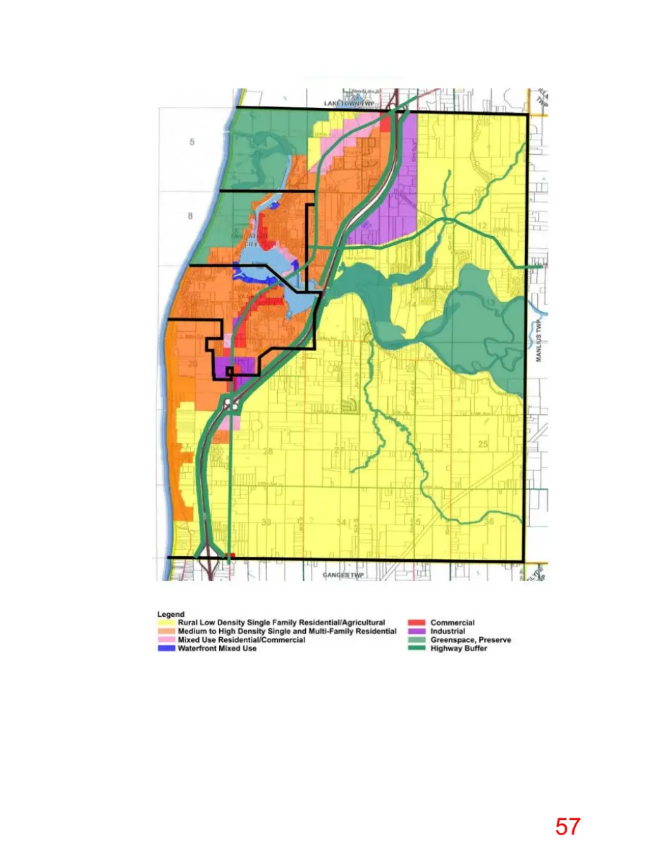
66. The 2005 Master Plan states: “The northwest corner of the Township, along with [ ] most of the land in Saugatuck west of the Kalamazoo lake should be preserved for public open space and the portion that remains in private ownership should be maintained for low intensity uses (like the art colony and church camp).” 49 67. The 2005 Master Plan and the 2016 master plan state: “Although waterfront lands have a high revenue generating potential, a major attraction of both the Lake Michigan and Kalamazoo River waterfronts is their scenic, natural shorelines composed of forested sand dunes and large wetland areas. Should these natural areas be greatly damaged or destroyed through inappropriate development, then the ‘goose that laid the golden egg’ will be dead. It is essential that the natural beauty of the waterfront be maintained along the Lake Michigan shoreline, the Kalamazoo River from the channel to Saugatuck, and from the Blue Star Highway Bridge inland.” 50 68. The 300-acre Patty Birkholz Natural Area is immediately adjacent to the proposed boat launch. It is one of only 20 legally designated natural areas in the State of Michigan, and the City finds its preservation as one of the preeminent natural areas in the State of great importance to the local community and City. 69. The Master Plan for Saugatuck Dunes State Park and Patty Birkholz Natural Area calls for a low-impact nature area. 70. The parking lot for these nature areas was situated to be as far from the natural area as possible to ensure no noise, vibrations, glare, or fumes would be introduced into this sanctuary. The proposed boat launch itself would be contrary to those extra efforts to maintain the natural area in pristine environmental condition and quality. 71. The City finds that the proposed boat launch is contrary to the well-established “public and private uses to which the area is suited.” 72. For reference, the City acknowledges that the following is the future land use map proposed by the 2016 Master Plan.
City of Saugatuck, et al., Tri-Community Master Plan 10-7 (2005). Id. at 8-1 through 8-2; City of Saugatuck, et al., Tri-Community Master Plan 8-1 through 8-2 (2016). 50
Page 57
This page is a scanned image with no text layer. The PDF of these pages has it at full resolution.
Page 58
Text of page 58
CONCLUSION 73. The City, as a “local agency having . . . . interest over the particular activity,” finds that the proposed boat launch is “contrary to the public interest.” 74. The City finds that the cumulative, permanent detrimental impacts of the construction of the proposed boat launch on property held by the City, adjacent natural areas, and on the Tri-Community tourist-based economy far outweigh any benefits from the construction of the boat launch. The City therefore finds that the boat launch is not necessary for development of the property at issue. 75. The City finds that the Tri-Community tourist-based economy relies on the preservation of the historical, ecological, and cultural values in the river mouth area. 76. The City finds that the proposed boat launch is contrary to the well-established “public and private uses to which the area is suited.” 77. The City finds that the proposed boat launch will create a significant increase in marine traffic at a vulnerable section of the Kalamazoo River Mouth and will create an unacceptable risk to public safety. 78. Based on the findings in this Resolution, the City of Saugatuck asks the United States Army Corps of Engineers to make an independent review of the need for the project from the prospective of the overall public interest. 79. Based on the findings in this Resolution, the City of Saugatuck asks the United States Army Corps of Engineers to strongly consider the public interest factors. YEAS: Council Members: NAYS: Council Members: ABSTAIN: Council Members: ABSENT: Council Members: RESOLUTION DECLARED ADOPTED. Dated:
Holly Anderson, Mayor
Page 59
Text of page 59
CERTIFICATION I, Jamie Wolters, the City Clerk of the City of Saugatuck, do hereby certify the foregoing is a true and complete copy of a resolution adopted by the Saugatuck City Council at a regular meeting held on ________________, in compliance with the Open Meetings Act, Act No. 267 of the Public Acts of Michigan, 1976, as amended, for which the minutes of the meeting were kept and will be or have been made available as required by said Act. Attest:
Jamie Wolters, City Clerk